(Children's Game)Biblio.com
62 résultats
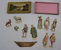
182518320French: n.p. 1825. Very good. 11 engraved cut-out figures or objects including ferryman three couples wolf goat cabbage and boat to be slotted into boat original box with engraved pictorial label colored by hand A rare children's game possibly printed by the Parisian publisher Nepveau. Contained in the box measuring 14cm x 7cm x 1cm is a complete set of figures for the two river crossing puzzles known as the 'Jealous Husbands Problem' and 'Goat Wolf and Cabbage'. The earliest account of these puzzles is in the 9th century manuscript "Propositionnes ad Acuendos Juvenes" Problems to Sharpen the Young attributed to Alcuin. In both puzzles there are only two places in the boat. In the Jealous Husbands Problem no woman can be with another man unless also accompanied by her husband. In Goat Wolf and Cabbage the wolf will eat the goat and the goat will eat the cabbage unless they are guarded by the boatman. <br /> Originally accompanied by counters and an instruction sheet now lost. The box is lightly worn else in very good condition; the figures are in fine condition except the boat which has been repaired and the cabbage which lacks the lower part of its insertion tab and one female figure lacks a hand. Rare. n.p. unknown
189578554August 1895 - 1978. original padded leather. The album's spine is perished with light wear at edges; contents sound and fine. 8vo. Illustrated throughout. The first page is an amusing original hand-colored cartoon of a Victorian couple cowering in front of a pig initialled "A.T." Following are 175 pig drawings all signed and most dated and many with a location. Dozens are neatly filled in in black and one is flesh-colored. 117 drawings were made between 1895-1900; 26 from 1900-1910 . hardcover
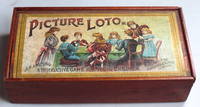
188040199London: J. Jaques & Son c.1880. Twelve cards showing 18 pictures each - a total of 216 pictures plus 207 tiles with the names of the pictures in both English and French - so lacking 9 and with some handwritten replacements included. Original wooden box with a pictorial sliding lid not fitting well but otherwise sound. Scarce. The price includes VAT in the UK. Please contact us if you are elsewhere. London: J. Jaques & Son unknown
1874246686London: Chapman and Hall 1874. First edition secondary binding. vi 337. 1 vols. 8vo. Green cloth spine titled in gilt. Very good minor rubbing. First edition secondary binding. vi 337. 1 vols. 8vo. Tiger hunting in Central India with notes on leopard. The author "also relates numerous stories from other sportsmen focusing on hunting bear rogue elephant and the like" Czech. Czech Asia p. 2 Chapman and Hall unknown
189941810Wynkoop Hallenback Crawford Co. State Printers 1899. First edition. Cloth with gilt titles stamped in blind string tied. Maps very good with small splits at corner folds colors bright in very good portfolio with small soiled spot on front and some sunning to spine. 1 colored map on 2 joined sheets 102 x 121 cm. Each map is 32 3/4 x 25 1/2 inches. Issued in portfolio 9 1/4 x 5 3/4 inches with cover title: Map of the Catskill Preserve. Engraved by J.Y. McClintock and W.L. Lawton. Over four feet if joined scale is 1 inch to 2 miles. Shows patents lots names of landowners and town boundaries subdivided into tracts. Shows street names and railroads. Compiled from "Official Maps and Field Notes on file in the State Departments at Albany N.Y. by Authority of the Fisheries Game and Forest Commission." The first meeting of the Forest Preserve Commission was held on September 23 1885 and a tabulation of the state ownership did not exist yet; in 1892 the State provided $250 the Forest Commission "for completing the public path leading to the summit of Slide mountain Ulster County included within the preserve." and in a 1893 budget bill Chapter 726 the State provided $1000 "For the expenses of examination of title and survey of lands owned by the state on Slide Mountain in Ulster County and other parts of the Catskills." which lead to the creation of this first map of the Catskill Forest Preserve. Quite detailed and in remarkably good condition. Wynkoop Hallenback Crawford Co. State Printers hardcover
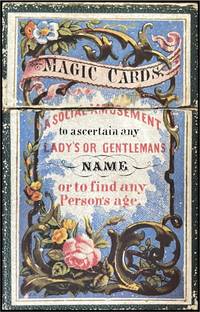
185019999England 1850. 18 cards 89 x 54 mm 9 printed on pink cardstock and 9 on yellow. Housed in original slipcover made of pebbled green paper over boards with chromolithographed label affixed to the front open at top and bottom. Light wear to edges of slipcover otherwise in excellent condition. A charming and unusual magic card game based on mathematical principles that purports to reveal anyone’s name and age. Using the pink cards for women and yellow for men the questioner holds onto the instruction and key cards and gives the player the rest of them which have lists of names and numbers and the letters A E I O U W and Y at the top. The player tells the questioner the letters corresponding to which cards have their name on them and using the key the questioner adds their corresponding numbers to get the player’s name provided it is one of the 127 names listed. The game is played the same way to determine players’ ages. The game actually works! unknown
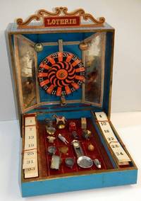
19002210013<p><i>Wooden box 32 x 26 x 8 cm with light blue patterned paper covering; the lid with a label lettered 'Loterie' and a hinged pierced wooden sign with the words 'Loterie' lettered in gilt paper on red; the lined paper interior with a central mounted wheel between mirrored sides and two hanging silk balls; the fall front where the prizes are held with two spaces left and right containing six lottery cards one from another set together with 16 toy prizes as listed below.</i></p><p>Lottery or carnival wheels games became popular at the end of the nineteenth century. Their construction was more complicated than heretofore with the addition of a rotating wheel with pins with a 'clack' mechanism sounding as the wheel is spun. The numbers on the wheel are randomly arranged from 0 through to 25 in white on alternating in black and red ground - clearly based on the 'single zero' form of roulette wheel that became the norm in Europe from the middle of the nineteenth century. The design has a second purpose as the box is hinged so that open it is given the form of a fairground entertainment with an assortment of prizes laid out in a display on squares below the wheel that each have a number too. </p><p>The idea of the game is twofold firstly as the wheel is spun and numbers called out the player who first completes a card of numbers is the winner. In the second game when the numbers 1 to 16 are called out and a player has the number on one of the cards they can then claim one of the small toy prizes. The sixteen twenty assorted of toy prizes include: a handcart wall clock bracelet scales pram wooden top bracelet fairground horse two rabbits a chicken a dish a parcel a metal top metal puzzle pair antimony jardinieres and a heart broach.</p><p>There is no makers name and the design although of a solid construction is nevertheless probably a bespoke production possibly made in order to be sold through fairgrounds and market stalls rather than the more salubrious emporia for children. The interior is lined in turquoise paper with bevelled mirrored silvered card sides and although simple the idea was glittery enough to catch any passing child's attention.</p>
1891335233eme. Ed. revue et corrigée.- Paris: Octave Doin Ed. 1891.- XXXII-398 p. en numeración continua: Ilustraciones; 8º 189 x 125 cm.; Texto en francés; Fina encuadernación a la alemana en Tela Nueva tejuelo. La portadilla con una falta de papel pequeña en su base. El papel algo grisáceo. Por lo demás en buen estado. ESOTERIA TEOSOFÃA PARAPSICOLOGÃA ALQUIMIA CARTOMANCIA SECTAS Y CIENCIAS OCULTAS EN GENERAL Livre en français Octave Doin hardcover
189146035Paris: Octave Doin 1891. Fine. Octave Doin Paris 1891 11.50 x 18.50 cm broché Third edition with some parts in first edition as revised and corrected. Work illustrated with figures in the text. Light tear with minimal lack at head of first board two slight marginal lacks on second board some foxing. Rare. Octave Doin unknown
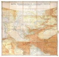
1881149774St Petersburg: Cartographic Institute of the Military-Topographic Department of the General Staff 1881. The cartographic climax of the "great game" Second edition significantly improved from the first edition 1877 to incorporate the latest military intelligence from field surveys. This magisterial work of "great game" cartography was presented at Russia's Tashkent military headquarters to the daring French explorer Stanislas Benoist-Méchin during his epic 1881-3 overland journey from Beijing to Europe. We have traced no other copies. A presentation inscription on the verso of the map reads in French "To Mr Baron Benoist-Méchin from Generals Kouropatkine and Levaschew October 1882 Tashkent." Benoist-Méchin 1854-1923 began travelling the world as a young man and then served as the French cultural attaché in Tokyo 1880-1. In 1881 he decided to return to Europe via the daring route through Central Asia. Leaving Beijing on 15 September with his regular travelling companion Comte Humbert Adrien de Mailly-Chalon 1853-1921 he journeyed through Manchuria and across Russian Siberia. In 1882 having reached Kashgar they received permission to cross Russian Turkestan spending six weeks in Tashkent as the honoured guests of General Mikhail Tchernayev the architect of Russian's expansion across Central Asia General Aleksey Nikolayevich Kuropatkin 1848-1925 and the aforementioned General Levaschov likely the artillery officer Vladimir Levaschov 1834-1898. After reaching Samarkand they travelled in extreme cold through Bukhara and via Khiva to Tehran reaching Moscow in October 1883 where they were accorded a hero's welcome. Their descriptions of this feat of exploration were published in 1885 in the Bulletin de la Société de géographie. This map was made for the use of the Russian military high command in St Petersburg and in the Turkestan Military District which had been established in the 1860s amid the occupation of Tashkent and Bokhara and dates from a period following the Second Anglo-Afghan War and the Battle of Geok Tepe when tensions were at their height. It encompasses almost the entire playing surface of the "great game" extending east-west from Xinjiang and Tibet to the Caspian Sea and Afghanistan and north-south from Siberia to northern India. Unparalleled in terms of accuracy and detail it names every city town and village and the legend has entries for such features as fortifications railways mail and caravan roads and mines. Spot heights are given in feet and deserts are marked with a light red pattern. It is much improved on the first edition which had only 48 panels and did not extend as far south. Chromolithograph map 195 x 200 cm dissected onto 64 sections and mounted on linen as issued laid-down printed slip stating "corrected up to 1881" small folding tab at right edge. Folding away to 28.5 x 28 cm. Housed in green quarter morocco solander box with chemise by the Chelsea Bindery. Map surface generally clean and brighta few stains toning and soiling at edges small repair at top-left edge verso foxed and with couple of areas of linen reinforcement: very good. unknown
190025498Madrid: La Caza Ilustrada 1900.- Año IV: desde el nº 76 10 de enero de 1900 hasta el nº 110 20 de diciembre de 1900; 4º mayor 27 cm.- En total son 30 fascículos que abarcan el año completo a falta de 5. Se venden todos como colección conjunta al precio indicado. Como se indica faltan 5 números para completar el año. Su estado de conservación es muy bueno sobre todo dado el tiempo transcurrido y que los fascículos se hallan sueltos. CAZA Y PESCA Libro en español La Caza Ilustrada paperback
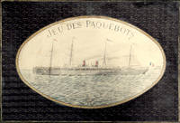
18972210164<p><i>Comprising two coloured map board 66 x 99 cm folding down to 32.5 x 49.5 cm one cloth hinge broken; 14 route cards; a barometer dial 19 x 19 cm with gilt metal spinning arrow some abrading from use; eight painted white metal playing pieces in the form of ships contained in the original small box one piece not original; 16pp booklet of instructions bound in original light green printed wrappers; all contained in the original box 35 x 52 x 5 cm; the hinged lid with a large coloured lithograph title label showing the 'Normandie' leaving port at full steam some minor abrasions but overall in good condition.</i><br /></p><p><i>Jue des Paquebots</i> was something new to games when it was published in 1897 as each player moves their boats on large maps exactly replicating the routes taken by two major French shipping lines. </p><p>The game includes two large folding boards designated 'Carte A' which illustrates the Atlantic shipping lines the other 'Carte B' with the shipping lines leaving Marseilles in the direction of the Black Sea the Indian Ocean and the Pacific. Rather pointedly the instructions state that the two maps include only the French shipping lines of the Messageries Maritimes and the Cie Générale Transatlantique the United Kingdom then the leading maritime nation is neither shown on the maps nor mentioned. </p><p>The players first decide which map they are going use and then select or bid one of the Itinerary cards 8 for map A and 6 for map B. The aim of each player is to complete the journey indicated by their itinerary and then make the return voyage; the first player to complete this double crossing wins. However the number of stopovers is not equal for each different itinerary in play. In order to equalise the chances of winning the players with the fewer ports of call have to repeat their journey a second or even a third time if necessary until the number of ports visited or passed by them in these different routes equates to the number of ports of the busiest route.</p><p>The routes all follow those which the two major French shipping companies plied. These include final destinations at Yokohama Australia New Zealand Zanzibar Odessa Buenos Ayres New York and the Antilles. </p><p>Each player places a ship playing piece at port at the beginning of their route. The first player now spins the Barometer Dial which has outer and inner instructions that allows them to advance out of port when their turn come around again the arrow is again spun and the player can read the inner line of instructions and so advance 1 2 or 3 ports along their route. However there are also stops on the Barometer Dial that include Damage - where you go back to the previous port and pay a token to the bank; Heavy Fog - where you are left stranded until the next round; Collision - this allows another turn of the dial but it the result is 50/50 chance of being sunk and thrown out of the game - you can pay for another ships so all is not lost; Call for Distress - also misses a turn; Shipwreck - something like collision although you can start out again with a new ship and no fine; Rescue - also causes the player to miss a turn; lastly and somewhat topical there is Quarantine - here the player misses a turn and also has a second spin of the arrow to determine if you can go into port or not.</p><p>The lid of the box illustrates the Cie Général Transatlantique liner La Normandie that plied the North Atlantic to New York in the summer and the south Atlantic in the winter - the ship sports a US flag on the foremast and the makers initials on the aft mast. Built in 1886 it was the largest and fastest liner of the company and was originally named 'Ville de New York.' It was also lit by electricity and could carry 1000 passengers and became the model for several sister ships built to the same plan.</p><p>The maker Charles Watilliaux succeeded the games manufacturer Coqueret in 1874 and for the next 35 years became a major publisher and manufacturer of board games and toys until their acquisition by Revenaz & Tabernat. His registered initials were 'W.X.' which is slightly modified for the flag on the box lid as C.W.X.</p> Watilliaux, éditeur.
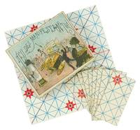
18951270431895. Paris: n.d. ca 1895. <br /> <br /> Original box 85 x 73 x 20 mm covered in gilt-patterned paper with mounted color illustrated title on outside lid and printed instructions slip on inside lid. With 8 printed rectangular card game pieces plus the rare color printed solution sheet 120 x 120 mm folded twice. Minor split to one edge of the lid a few small tears to the sheet otherwise a very good and complete example of this rare and fragile game.<br /> <br /> § A very early apparently the first issue of this French "game of protesters" in which the player takes on the part of a police officer attempting to prevent people from assembling at a demonstration. <br /> <br /> Not located in OCLC although other searches reveal copies in the Indiana Lilly Library in the Jerry Slocum Mechanical Puzzle Collection one within a "coffret de jeu" a boxed group of puzzles and games at the Musée du Jouet de Poissy and another a variant in which the game pieces are triangular at the Marseille Musée des Civilisations de l'Europe et de la Méditerranée MUCEM. Later issues with varying artwork can also sometimes appear.<br /> <br /> The Marseille museum's copy featured in a forum held on February 5 2024: "Faut-il parler des violences policières" "Should we talk about police brutality". The curator Mireille Jacotin explained: "Jeu des manifestants is a game in which you are the hero that is to say the police officer and as the accompanying instructions explicitly state you are firmly positioned on the side of the public authority responsible for maintaining order. In reality the game consists of arranging a set of cardboard pieces-printed on a right-angled triangle-shaped board-in such a way as to ensure that no two red dots end up on the same line. The underlying concept is to simplify the police's task by ensuring that they do not face a mere undifferentiated crowd-and certainly not any organized lines requiring a tactical breach such as a battlefront during wartime. The game board features no specific characters; instead it presents a simple grid-comprising lines and sectors-that serves as a framework for devising and visualizing a strategic plan atop a generic cartographic representation of public space. The red dots in this scenario represent the demonstrators. On the lid of the box however is an urban scene: an overturned double-decker bus a urinal figures stirring in the distance and a policeman in the foreground." For the original French see https://www.davduf.net/le-jeu-des-manifestants-1895. <br /> <br /> It seems likely this game was inspired by the many protests that took place in Paris throughout the 1890s including the birth of the international May Day demonstrations. unknown
187027855France 1870. Board game. Fine. A French childrens' board game complete with the folding board 10 number disks 6 wooden pieces the instruction sheet and box. The box is papered in apricot & gold spotted paper with an image on the cover of clowns ascending a pyramide and one tumbling down. The box measures 11 x 8". All in very good condition. unknown
187537921Paris: M.J. & Cie 1875. 10 1/4 x 10 1/4 x 5 inches. Some minor wear. 10 1/4 x 10 1/4 x 5 inches. M.J. & Cie unknown
18997146State of New York. Good. 1899. Hardcover. Light green stamped on dark green and black. Library marks on spine front rear endpapers and title page; library numbers we think at top corner of Mallard Duck male plate. First 14 pages including 3 plates almost completely pulled away from binding. 17 color plates present. Some listings mention a color fold-out map; I do not see one in illustrations list and there is no map with this copy. . State of New York hardcover
18979211Albany New York U.S.A.: Wynkoop Hallenbeck Crawford Co 1897. First edition. Hardcover. Good/No Dust Jacket. Various. The blue blind stamped boards have an illustration trees shore lake and mountains on front board done in black . The spine and one-quarter of the front board are sun faded. The top of spine has a 1 cm tear as does the lower corner of the front board. The front hinge shows three short tears to 1 cm with the cloth backing still intact. The title page has two creases on it from top to bottom. The front free page has been signed 'Compliments of Edward Thompson' who was one of the commissioners and authors. The previous owner has sign the front free page as well. Pages 521.Printer Wynkoop Hallenbeck Crawford Co. <br/><br/> Wynkoop Hallenbeck Crawford Co hardcover
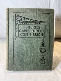
18989212Albany New York U.S.A.: Wynkoop Hallenbeck Crawford Co 1898. First edition. Hardcover. Very Good Minus/No Dust Jacket. Various. The green blind stamped boards have an illustration of a wrought iron work displaying a sign 'Fisheries Game & Forest Commission' with a fish deer antlers and three axes. They are illustrated in black. The previous owner has signed the front free page and there is a signature stamp from the State Superintendent of Public Instruction - 'Charles R. Skinner'. There is one tipped in illustration missing on page 318 entitled 'Wake Robin' Sugar Bush. The book contains a fold out map on page 372. The book is in very good condition other than the missing illustration. The book contains 455 pages.Printer Wynkoop Hallenbeck Crawford Co. <br/><br/> Wynkoop Hallenbeck Crawford Co hardcover