CORONELLI Vincenzo (Venezia 1650 - 1718)MareMagnum

187 résultats
Affascinante incisione che mostra strumenti cartografici e simboli allegorici, con un Globo Terrestre orientato verso il Polo al centro. Esemplare tratto dall’ Atlante Veneto, Nel quale si contiene la Descrittione Geografica, Storica, Sacra, Profana e Politica degli Imperi, Regni, Provincie, e Santi dell’Universo […] In Venetia MDCXC. Coronelli visse un periodo di straordinaria fecondità editoriale a partire dal 1689, quando ebbe la cattedra di geografia presso l'Università alle Procuratie, con la pubblicazione, nel 1690, del primo volume dell'Atlante Veneto. In effetti sotto il nome di Atlante Veneto va tutta la raccolta di tredici opere composte nell'arco del decennio successivo, dall'Isolario allo Specchio del mare. L'opera era intesa come un'estensione dell'Atlas Maior di Blaeu. Non è una semplice raccolta di mappe, ma piuttosto "un compendio di informazioni geografiche, cosmografiche e scientifiche... sulla scienza e la geografia italiana contemporanea" (Scammell). Oltre alle mappe, il primo volume include molte delle celebri tavole navali di Coronelli, molte con i bordi "farnesiani" stampati separatamente e commissionati appositamente dal patrono di Coronelli, Ranuccio II Farnese, duca di Parma. Incisione in rame, magnifica prova con pieni margini, in perfetto stato di conservazione. Bibliografia Ermanno Armao, Vincenzo Coronelli (Firenze, 1944), nn.59-60, p.237. Fascinating engraving showing cartographic instruments and allegorical symbols, with a globe oriented toward the Pole at the center. Example taken form Corenelli’s Atlante Veneto, Nel quale si contiene la Descrittione Geografica, Storica, Sacra, Profana e Politica degli Imperi, Regni, Provincie, e Santi dell’Universo […] In Venetia MDCXC. Coronelli lived a period of extraordinary editorial fecundity starting from 1689, when he had the chair of geography at the University at the Procuratie, with the publication, in 1690, of the first volume of the Atlante Veneto. Under the name of Atlante Veneto goes the entire collection of thirteen works composed over the next decade, from the Isolario to the Specchio del mare. The work was intended as an extension of Blaeu’s Atlas Maior. It is no mere collection of maps, but rather “a compendium of geographical, cosmographical, and scientific information... on contemporary Italian science and geography” (Scammell). As well as maps, the first volume includes several of Coronelli’s celebrated naval plates, many with the separately-printed “Farnese” borders especially commissioned by Coronelli’s patron, Ranuccio II Farnese, Duke of Parma. Copperplate, with full margins, very good condition. Very rare. Literature Ermanno Armao, Vincenzo Coronelli (Florence, 1944), no.59, no.60 and p.237.
Ritratto, in ovale, del celebre cartografo Gerard Mercator (1512-1594).Probabilmente è una copia di un'incisione attribuita a Hendrik Goltzius o a Frans Hogenberg. Il ritratto è uno dei numerosi realizzati per i due volumi di Isaac Bullerts "Académie des Sciences et Arts contenant les vies et éloges his. des hommes illustres qui ony excellé en ces professions depuis environ quatre siècles", editi a Brussles nel 1682 da François Foppens.Molti dei ritratti furono incisi da Nicolas de Larmessin I (1638-1694) e/o II (ca. 1645 - 1725).Alcune lastre furono anche utilizzate per stampe separate dal volume, che si distinguono per il verso bianco, come nel caso del presente esemplare.Bulino, rifilato alla linea marginale, in ottimo stato di conservazione. Portrait engraving of the cartographer Gerard Mercator (1512-1594), bust directed to left, wearing a flat cap and buttoned jacket; in an oval;Gerard Mercator.Probably copied after the engraving attributed to Hendrik Goltzius or Hogenberg.This print is one of the portraits engraved for the two volumes of Isaac Bullerts's "Académie des Sciences et Arts contenant les vies et éloges his. des hommes illustres qui ony excellé en ces professions depuis environ quatre siècles" (François Foppens: Brussels, 1682). Most of the engraved portraits are by Nicolas de Larmessin I and II.Some of the portraits were also printed seperatly, and have a blanc verso, as the present example.Engraving, blanc verso, trimmed to the platemark, in very good condition New Hollstein (Dutch & Flemish) 36 (Frans Hogenberg; copy undescribed); New Hollstein (Dutch & Flemish) D8 (Hendrick Goltzius; doubtful attributions; copy undescribed)
2390ou la France telle qu’elle fut, telle qu’elle est et à peu-près telle qu’elle pourra être, Ouvrage traduit du Celte & suivi d’un commentairein 8 plein cuir fauve raciné à nerfs pièce de titre chagrin rouge,fers dorés.frontispice gravé (L. DESRAIS)XXVII, 26 pages,tranches rouges,à Londres,Paris Valleyre l’ainé Lacombe 1775.édition originale.Coiffes restaurées ; " Allégorie politique à travers laquelle l’auteur exprime ses critiques sociales et politiques présentée comme le récit prophétique d’une druidesse gauloise.Proche des philosophes des Lumières,franc-maçon c’est lui qui fit l’éloge funèbre de Voltaire lors de l’hommage rendu par sa loge (Loge des Neuf Sœurs)." Très rare
Litografia, inciso mm. 522 x 730 su foglio di mm. 660 x 870 ca.. Bella litografia con allegoria della morte di Giuseppe Garibaldi contornata da episodi della vita militare dell'Eroe dei due mondi. Lievi arrossature ma ottimo esemplare. Rara.
- EDIZIONE ORIGINALE, COLORITURA COEVA -Frontespizio del terzo volume del "Nuovo Atlante Geografico Universale delineato sulle ultime osservazioni", edito a Roma dal 1792 fino al 1801, opera che la Calcografia Camerale commissionò al Cassini al fine di sostituire l’ormai obsoleto "Mercurio Geografico".Giovanni Maria Cassini, Chierico Regolare Somasco fu geografo e cartografo, ma anche intagliatore di architetture e prospettive - uno dei migliori discepoli di Giovanni Battista Piranesi - Cassini fu uno degli ultimi sferografi italiani del Settecento ed i suoi globi ebbero una notevole diffusione, come pure questo "Nuovo Atlante Geografico".Incisione in rame, coloritura coeva dei contorni, leggere bruniture, per il resto in ottimo stato di conservazione. L'Atlante del Cassini fu ristampato dalla Calcografia Camerale nel primo quarto del XIX secolo, prima del 1839. Solo gli esemplari di prima edizione come questo sono stampati su carta vergata coeva e sono colorati a mano in epoca. Le tirature del XIX secolo sono già su carta meccanica, priva di vergelle, e generalmente in bianco e nero. - FIRST EDITION, CONTEMPORARY OUTLINE COLOUR -Title page of the third book of Nuovo atlante geografico universale delineato sulle ultime osservazioni. Roma, Calcografia camerale, 1792-1801.Cassini was geographer and cartographer but he was also good at engraving architectural items and perspectives – he was one of the best disciples Giovanni Battista Piranesi had. Moreover, Cassini was one of the last artists to engrave spheres in the XVIII century and his globes were quite famous and widespread, and realized the most important Italian Atlas of the XVIII century; his maps always bear a cartouche, extremely rich in colours and details. Copperplate with fine original hand colour, some foxing, otherwise in very good condition.The Cassini's Atlas was reprinted by the Calcografia Camerale in the first quarter of XIXth century (before 1839). Only the first edition of the atlas is printed on contemporary laid paper, while the late issue are on XIXth century paper and often without colour.
- EDIZIONE ORIGINALE, COLORITURA COEVA -Frontespizio del secondo volume del "Nuovo Atlante Geografico Universale delineato sulle ultime osservazioni", edito a Roma dal 1792 fino al 1801, opera che la Calcografia Camerale commissionò al Cassini al fine di sostituire l’ormai obsoleto "Mercurio Geografico".Giovanni Maria Cassini, Chierico Regolare Somasco fu geografo e cartografo, ma anche intagliatore di architetture e prospettive - uno dei migliori discepoli di Giovanni Battista Piranesi - Cassini fu uno degli ultimi sferografi italiani del Settecento ed i suoi globi ebbero una notevole diffusione, come pure questo "Nuovo Atlante Geografico".Incisione in rame, coloritura coeva dei contorni, leggere bruniture, per il resto in ottimo stato di conservazione. L'Atlante del Cassini fu ristampato dalla Calcografia Camerale nel primo quarto del XIX secolo, prima del 1839. Solo gli esemplari di prima edizione come questo sono stampati su carta vergata coeva e sono colorati a mano in epoca. Le tirature del XIX secolo sono già su carta meccanica, priva di vergelle, e generalmente in bianco e nero. - FIRST EDITION, CONTEMPORARY OUTLINE COLOUR -Title page of the second book of Nuovo atlante geografico universale delineato sulle ultime osservazioni. Roma, Calcografia camerale, 1792-1801.Cassini was geographer and cartographer but he was also good at engraving architectural items and perspectives – he was one of the best disciples Giovanni Battista Piranesi had. Moreover, Cassini was one of the last artists to engrave spheres in the XVIII century and his globes were quite famous and widespread, and realized the most important Italian Atlas of the XVIII century; his maps always bear a cartouche, extremely rich in colours and details. Copperplate with fine original hand colour, some foxing, otherwise in very good condition.The Cassini's Atlas was reprinted by the Calcografia Camerale in the first quarter of XIXth century (before 1839). Only the first edition of the atlas is printed on contemporary laid paper, while the late issue are on XIXth century paper and often without colour.
- EDIZIONE ORIGINALE, COLORITURA COEVA -Frontespizio del primo volume del "Nuovo Atlante Geografico Universale delineato sulle ultime osservazioni", edito a Roma dal 1792 fino al 1801, opera che la Calcografia Camerale commissionò al Cassini al fine di sostituire l’ormai obsoleto "Mercurio Geografico".Giovanni Maria Cassini, Chierico Regolare Somasco fu geografo e cartografo, ma anche intagliatore di architetture e prospettive - uno dei migliori discepoli di Giovanni Battista Piranesi - Cassini fu uno degli ultimi sferografi italiani del Settecento ed i suoi globi ebbero una notevole diffusione, come pure questo "Nuovo Atlante Geografico".Incisione in rame, coloritura coeva dei contorni, leggere bruniture, per il resto in ottimo stato di conservazione. L'Atlante del Cassini fu ristampato dalla Calcografia Camerale nel primo quarto del XIX secolo, prima del 1839. Solo gli esemplari di prima edizione come questo sono stampati su carta vergata coeva e sono colorati a mano in epoca. Le tirature del XIX secolo sono già su carta meccanica, priva di vergelle, e generalmente in bianco e nero. - FIRST EDITION, CONTEMPORARY OUTLINE COLOUR -Title page of the first book of Nuovo atlante geografico universale delineato sulle ultime osservazioni. Roma, Calcografia camerale, 1792-1801.Cassini was geographer and cartographer but he was also good at engraving architectural items and perspectives – he was one of the best disciples Giovanni Battista Piranesi had. Moreover, Cassini was one of the last artists to engrave spheres in the XVIII century and his globes were quite famous and widespread, and realized the most important Italian Atlas of the XVIII century; his maps always bear a cartouche, extremely rich in colours and details. Copperplate with fine original hand colour, some foxing, otherwise in very good condition.The Cassini's Atlas was reprinted by the Calcografia Camerale in the first quarter of XIXth century (before 1839). Only the first edition of the atlas is printed on contemporary laid paper, while the late issue are on XIXth century paper and often without colour.
Frontespizio di Heroico Splendore delle Città del Mondo, rarissima pubblicazione stampata per la prima volta a Roma nel 1639, e successivamente, ampliata con l’aggiunta di dieci nuove opere, nel 1642. Giacomo Lauro, fu incisore, stampatore e conoscitore di antichità attivo prevalentemente in ambito romano tra il 1583 e il 1645. Non si conosce la data e il luogo di nascita, ma il fatto che egli firmasse le sue opere come "Jacobus Laurus Romanus" lascia presumere che fosse originario di Roma. Nulla si conosce della sua formazione. La prima testimonianza documentaria che attesta la sua presenza a Roma, in cui è definito "intagliatore di rame romano", risale al 1583; mentre la sua prima stampa conosciuta è un Tiberio con la daga (o Il gladiatore), pubblicata da Claudio Duchetti nel 1585. Nonostante abbia affrontato tematiche storiche, mitologiche, devozionali, il Lauro è noto soprattutto per la produzione di piante e vedute di città, a cominciare dalla veduta a volo d'uccello di Rocca Contrada (Arcevia), realizzata nel 1594 per Angelo Rocca su disegno di Ercole Ramazzani. Negli anni 1630-45, Lauro si dedicò alla pubblicazione di una serie di piante e descrizioni di città italiane e straniere in forma di piccoli opuscoli, alcuni dei quali furono raccolti nel 1639 sotto il titolo di Heroico splendore delle città del mondo. Le piante di Lauro, dunque, furono il frutto di un lungo lavoro di ricerca, basato su fonti primarie, e pubblicato per la prima volta in libri o opuscoli con testo relativo alla storia della città. Scrive Thomas Ashby: “Negli anni 1630-1645 il Lauro pubblicò un numero rilevante di descrizioni di città in tanti opuscoli col testo, tutti in folio piccolo oblungo. Le piante non sono tutte originali […] Molte volte sono state adoperate come fonti, s’intende, le belle tavole dell’atlante del Lafrèry. Ma anche altre piante sono state messe sotto contributo - molto è stato preso o dall’opera di Braun e Hogenberg, Civitales Orbis Terrarum, oppure anche in questo caso da fonti comuni. Non mancano i contatti con Matteo Florimi di Siena, il quale in nessun caso compì di opera propria, ma copiò sempre i lavori degli altri. La pianta di Viterbo, finalmente, è derivata dalla pianta di Tarquinio Ligustri di Viterbo, fatta nel 1596 e dedicata al Cardinale Odoardo Farnese, Alcune di queste piante furono raccolte sotto il titolo seguente, inciso nel 1639; HEROICO SPLENDORE DELLE CITTA DEL MONDO LIBRO PRIMO DI IACOMO LAURO ROMANO Dove si uedono le piante di molte Citta Ill.ri e di molte non più state alla stampa con le loro origini et atti segnalati, et quanto si estende il dominio di esse sino alli presenti tempi in Roma l’Anno di nostra salute 1639” (cfr. Thomas Ashby, L'Heroico splendore delle città del mondo, in “La Bibliofilia”, XXXI (1929), pp. 105-122). L’opera venne ristampata nel 1642 con imprint in Roma l’Anno di nostra salute 1642 /Con priuilegio del somo Pontefice, et d'altri Potent.ti Con licenza de Superiori. Sebbene nel frontespizio si parli di “Libro primo” un secondo volume della raccolta non venne mia pubblicato. Incisione in rame, stampata su carta vergata coeva, con margini, leggerissime ossidazioni, per il resto in ottimo stato di conservazione. Rarissima. Bibliografia Thomas Ashby, Un incisore antiquario del Seicento, I, Note intorno alla vita ed opere di Giacomo Lauro, in “La Bibliofilia”, XXVIII (1926-27), pp. 361-373; II, L'opera "Antiquae Urbis splendor", ibid., pp. 453-460; III, ibid., XXIX (1927), pp. 356-369; IV, L'Heroico splendore delle città del mondo, ibid., XXXI (1929), pp. 105-122. Title page of Heroico Splendore delle Città del Mondo, a very rare publication printed for the first time in Rome in 1639, and later, expanded with the addition of ten new works, in 1642. Giacomo Lauro, was an engraver, printer and connoisseur of antiquities active mainly in Rome between 1583 and 1645. We do not know the date and place of birth, but the fact that he signed his works as "Jacobus Laurus Romanus" suggests that he was a native of Rome. Nothing is known about his education. The first documentary evidence of his presence in Rome, in which he is defined as a "Roman copper engraver", dates back to 1583; while his first known print is a Tiberius with a dagger (or The Gladiator), published by Claudio Duchetti in 1585. Although he dealt with historical, mythological, devotional themes, Lauro is mainly known for the production of plans and views of cities, starting with the bird's eye view of Rocca Contrada (Arcevia), made in 1594 for Angelo Rocca on a drawing by Ercole Ramazzani. In the years 1630-45, Lauro dedicated himself to the publication of a series of maps and descriptions of Italian and foreign cities in the form of small pamphlets, some of which were collected in 1639 under the title of Heroico Splendore delle Città del Mondo. Lauro's plans, therefore, were the result of a long research work, based on primary sources, and published for the first time in books or pamphlets with text related to the history of the city. Thomas Ashby writes: "In the years 1630-1645 the Lauro published a considerable number of descriptions of cities in many pamphlets with text, all in small oblong folio. The plants are not all original [...] Many times have been used as sources, of course, the beautiful plates of the Atlas of Lafrèry. But other maps were also contributed - much was taken either from the work of Braun and Hogenberg, Civitales Orbis Terrarum, or even in this case from common sources. There is no lack of contact with Matteo Florimi of Siena, who in no case did his own work, but always copied the work of others. Some of these maps were collected under the following title, engraved in 1639; HEROICO SPLENDORE DELLE CITTA DEL MONDO LIBRO PRIMO DI IACOMO LAURO ROMANO Dove si uedono le piante di molte Citta Ill.ri e di molte non più state alla stampa con le loro origini et atti segnalati, et quanto si estende il dominio di esse sino alli presenti tempi in Roma l’Anno di nostra salute 1639” (see Thomas Ashby, L'Heroico splendore delle città del mondo, in "La Bibliofilia", XXXI (1929), pp. 105-122). The work was reprinted in 1642 with imprint in Roma l’Anno di nostra salute 1642 /Con priuilegio del somo Pontefice, et d'altri Potent.ti Con licenza de Superiori. Although the title page speaks of "Book one" a second volume of the collection was not published. Copper engraving, printed on contemporary laid paper, with margins, very light oxidation, otherwise in excellent condition. Very rare. Bibliografia Thomas Ashby, Un incisore antiquario del Seicento, I, Note intorno alla vita ed opere di Giacomo Lauro, in “La Bibliofilia”, XXVIII (1926-27), pp. 361-373; II, L'opera "Antiquae Urbis splendor", ibid., pp. 453-460; III, ibid., XXIX (1927), pp. 356-369; IV, L'Heroico splendore delle città del mondo, ibid., XXXI (1929), pp. 105-122.
Acquaforte e bulino, 1729, firmata e datata in lastra in basso a sinistra.Magnifica prova, ricca di toni, impressa su carta vergata coeva, con margini, in ottimo stato di conservazione.Minerva e le scienze mettono un busto di Luigi XIV in una stanza decorata con busti scolpiti di altri uomini illustri; a destra, due personificazioni delle scienze fanno ghirlande di alloro; sopra di loro la Fama, che suona la sua tromba; tavola tratta da "Eloges des académiciens de l'Académie royale des Sciences", in "Oeuvres diverses" di Fontenelle. Etching and engraving, 1729.Lettered with production detail: 'B. Picart del. et sculp. 1729', title: 'Eloges des académiciens de l'Académie royale des Sciences', three lines of inscriptions in French, and explanatory key.Minerva and the Sciences setting a bust of Louis XIV in a room decorated with sculpted busts of other illustrious men; on the right, two personifications of Sciences are making laurel wreaths; above them flies Fame, who blows her trumpet; illustration to 'Eloges des académiciens de l'Académie royale des Sciences', in Fontenelle's 'Oeuvres diverses' (La Haye: Gosse & Neaulme, 1728-1729).A fine impression, very good condition. Dimier, Louis, Les peintres français du XVIIIe siècle, histoire des vies et catalogue des oeuvres, 1928, nn. 1500-1570.
17792200231779. In der Platte bezeichnet: "Vangelisti Inv. et Sculp. 1780". Druck auf festem Bütten. Darstellung: 21,2 x 27,2 cm. Blatt:29,4 x 30,8 cm.
162580715Frankfurt a. M. [ca. 1625]. Darstellung 10,0 x 14,5 cm. Unter starkem Schrägschnitt-Passepartout mit vergoldeten Schnittkanten im Rahmen aus vergoldeter Profilleiste (diese etwas bestoßen).
Acquaforte, 1765 circa, firmata in lastra in basso a sinistra con il nome dell'inventore Marillier.Bellissima prova, impressa su carta veragata coeva, con margini, in ottimo stato di conservazione.Tavola della serie "Nouveaux trophées ou cartouches représentant les arts et les sçiences composés avec les atributs qui les caractérisent inventés et dédiés a Mr Morlot peintre par son elève et son ami Marillier" stampata a Parigi "Chez Mondhare rue St Jacques a l'hôtel Saumur". Etching, 1765 circa, signed on plate at lower left by the drawer Marillier.A fine impression, printed on contemporary laid paper, with margins, very good conditions.Plate from the "Nouveaux trophées ou cartouches représentant les arts et les sçiences composés avec les atributs qui les caractérisent inventés et dédiés a Mr Morlot peintre par son elève et son ami Marillier" printed in Paris "Chez Mondhare rue St Jacques a l'hôtel Saumur".
186652348London: Longmans Green Reader and Dyer Paternoster Row 1866. Thick 4to. xii 2 239 1 pp. Woodcut-engraved & illustrated title in red & black illust. half-title in red & black red & black frontisp. many leaves printed in blue red yellow or green woodcut-engraved plates historiated initials head- and tail-pieces woodcut borders. Contemporary full red morocco with gilt ornamented designs on front & back cover gilt decorated spine raised bands marbled endpapers t.e.g. very minor rubbing at hinges minor rubbing to corners very slight tidemark to fore-edge of first couple leaves still a NF copy bound by Riviere w/ their stamp on lower fore-edge of inner ruled dentelle on front pastedown. First edition of this lavish Victorian work celebrating the life span of man in the 12 months of a calendar year beginning with the infant in January the schoolboy in February the apprentice in March as well as the soldier in June the philosopher and statesmen in September and more. Pigot has drawn upon the verse of Bacon Cicero Carlyle Caxton Chaucer Dickens Dryden Emerson Goethe Martial Shakespeare Sallust and Virgil. Longmans, Green, Reader, and Dyer, Paternoster Row, hardcover
Frontespizio dell'edizione francese dell'Atlas Novus di Blaeu. Willem Janszoon Blaeu, avviò nel 1599 la sua attività di costruttore di globi e strumenti astronomici ad Amsterdam. Nel 1630, dopo aver comprato alcune lastre dell’atlante del Mercator da Jodocus Hondius II, fu in grado di pubblicare un volume di 60 mappe con il titolo di Atlantis Appendix. Cinque anni dopo, pubblicò i primi due volumi del suo atlante Atlas Novus o Theatrum Orbis Terrarum, in sei libri. Dopo la sua morte, Joan (Johannes) continuò l’opera paterna, completando l’intera serie di sei volume dell’Atlas Novus intorno al 1655. Fu inoltre autore di un Atlas Maior sive Cosmographia Blaviana, in 12 volumi pubblicati nel 1662 -72. Incisione in rame, bella coloritura coeva, in ottimo stato di conservazione. Title page of the French edition of Blaeu's Atlas Novus. Willem Janszoon Blaeu, started in 1599 his business as a builder of globes and astronomical instruments in Amsterdam. In 1630, after buying some plates of the Mercator atlas from Jodocus Hondius II, he was able to publish a volume of 60 maps under the title Atlantis Appendix. Five years later, he published the first two volumes of his atlas Atlas Novus or Theatrum Orbis Terrarum, in six books. After his death, Joan (Johannes) continued his father's work, completing the entire six-volume Atlas Novus series around 1655. He was also the author of an Atlas Maior sive Cosmographia Blaviana, in 12 volumes published in 1662 -72. Copperplate with fine original hand colour, very good condition.
Frontespizio del secondo volume dell'edizione francese del "Civitates Orbis Terrarum", il primo atlante devoto esclusivamente alle piante e vedute delle principali città del mondo. Stampato in sei volumi tra il 1572 ed il 1617 ebbe grande fortuna e diffusione, tanto che ne furono stampate diverse edizioni tradotte in latino, tedesco e francese. Il primo volume delle Civitates Orbis Terrarum fu pubblicato a Colonia nel 1572. Il sesto e ultimo volume apparve nel 1617. Questo grande atlante di città – cartografia urbana - curato da Georg Braun e inciso in gran parte da Franz Hogenberg, conteneva 546 prospettive, vedute a volo d'uccello e vedute cartografiche di città di tutto il mondo. Franz Hogenberg realizzò le tavole dei primi quattro volumi e Simon van den Neuwel (Novellanus, attivo dal 1580) quelle dei volumi V e VI. Georg Braun (1541-1622), un ecclesiastico di Colonia, fu il principale redattore dell'opera e fu molto aiutato nel suo progetto dalla vicinanza e dal continuo interesse di Abraham Ortelius, il cui Theatrum Orbis Terrarum del 1570 fu, come raccolta sistematica e completa di mappe di stile uniforme, il primo vero atlante. Le Civitates, in effetti, erano destinate ad accompagnare il Theatrum, come indicato dalla somiglianza dei titoli e dai riferimenti contemporanei sulla natura complementare delle due opere. Tuttavia, le Civitates erano progettate per avere un approccio più popolare, senza dubbio perché la novità di una raccolta di piante e vedute di città rappresentava un'impresa commerciale più rischiosa di un atlante mondiale, per il quale c'erano stati diversi precedenti di successo. Franz Hogenberg (1535-1590) era figlio di un incisore di Monaco che si era stabilito a Malines. Incise la maggior parte delle tavole del Theatrum di Ortelius e la maggior parte di quelle delle Civitates, e potrebbe essere anche indicato come il responsabile dell'origine del progetto. Oltre un centinaio di artisti e cartografi diversi, il più importante dei quali fu l'artista di Anversa Georg Hoefnagel (1542-1600), fornirono i disegni per le tavole delle Civitates. Hoefnagel non solo contribuì alla maggior parte del materiale originale per le città spagnole e italiane, ma rielaborò e modificò anche quello di altri collaboratori. Dopo la morte di Hoefnagel, il figlio Jakob continuò il lavoro per le Civitates. Gli autori della raccolta si proponevano di raffigurare "non icones et typi urbium", cioè non immagini generiche e tipizzate, "sed urbes ipsae admirabili caelaturae artificio, spectantium oculis subiectae appareant": non intendeva alludere o idealizzare, ma rappresentare fedelmente sulla carta, riprodurre esattamente, e in tempo reale, ciò che l'occhio vede, come annunciato nella prefazione al primo volume delle Civitates Orbis Terrarum. Incisione in rame, magnifica coloritura a mano, in ottimo stato di conservazione. Title page of the second volume of the French edition of Civitates Orbis Terrarum, the first atlas devoted exclusively to plans and views of the world's major cities. Printed in six volumes between 1572 and 1617 it was so successful and widespread that several editions translated into Latin, German and French were printed. The first volume of the Civitates Orbis Terrarum was published in Cologne in 1572. The sixth and the final volume appeared in 1617. This great city atlas, edited by Georg Braun and largely engraved by Franz Hogenberg, eventually contained 546 prospects, bird-eye views and map views of cities from all over the world. Fransz Hogenberg produced the plates for the first four books, and Simon van den Neuwel (Novellanus, active since 1580) those for volumes V and VI. Georg Braun (1541-1622), a cleric of Cologne, was the principal editor of the work, and was greatly assisted in his project by the close, and continued interest of Abraham Ortelius, whose Theatrum Orbis Terrarum of 1570 was, as a systematic and comprehensive collection of maps of uniform style, the first true atlas. The Civitates, indeed, was intended as a companion for the Theatrum, as indicated by the similarity in the titles and by contemporary references regarding the complementary nature of two works. Nevertheless, the Civitates was designs to be more popular in approach, no doubt because the novelty of a collection of city plans and views represented a more hazardous commercial undertaking than a world atlas, for which there had been a number of successful precedents. Franz Hogenberg (1535-1590) was the son of a Munich engraves who settled in Malines. He engraved most of the plates for Ortelius's Theatrum and the majority of those in the Civitates, and may have been responsible for originating the project. Over a hundred of different artists and cartographers, the most significant of whom was Antwerp artist Georg Hoefnagel (1542-1600), engraved the cooper-plates of the Civitates from drawings. He not only contributed most of the original material for the Spanish and Italian towns but also reworked and modified those of other contributors. After Hoefnagel's death his son Jakob continued the work for the Civitates. The author set out to depict "non icones et typi urbium," that is, not generic and typified images, "sed urbes ipsae admirabili caelaturae artificio, spectantium oculis subiectae appareant": not intended to allude or idealize but to represent faithfully on paper, to reproduce exactly, and in real time, what the eye sees, as announced in the preface to the first volume of Civitates Orbis Terrarum. Copperplate with fine clouring, very good conditions.
Frontespizio del "Atlas Novus" di Janssonius. Joannes Janssonius, figlio dell'editore di Arnhem Jan Janssen, sposò Elisabeth Hondius, figlia di Jodocus Hondius, ad Amsterdam nel 1612. Dopo il suo matrimonio, si stabilì in questa città come libraio ed editore di materiale cartografico. Nel 1618 si stabilì ad Amsterdam accanto alla libreria di Willem Jansz. Blaeu, entrando in una seria competizione. Le sue attività non riguardavano solo la pubblicazione di atlanti e libri, ma anche di mappe singole e un vasto commercio di libri con filiali a Francoforte, Danzica, Stoccolma, Copenaghen, Berlino, Koningsbergen, Ginevra e Lione. Nel 1631 iniziò a pubblicare atlanti insieme a Henricus Hondius. Nei primi anni 1640 Henricus Hondius lasciò l'attività di pubblicazione di atlanti completamente a Janssonius. La concorrenza con Joan Blaeu, figlio e successore di Willem, nella produzione di atlanti spinse Janssonius ad ampliare il suo Atlas Novus finalmente in un'opera di sei volumi, in cui furono inseriti un atlante marino e un atlante del Vecchio Mondo. Dopo la morte di Joannes Janssonius, il negozio e la casa editrice furono continuati dagli eredi sotto la direzione di Johannes van Waesbergen (c. 1616-1681), genero di Joannes Janssonius. Le matrici degli atlanti di Janssonius furono in seguito vendute a Schenk e Valck. Incisione in rame, coloritura coeva, in buono stato di conservazione. Title page of Janssonius' "Atlas Novus". Joannes Janssonius (Arnhem, 1588-1664), son of the Arnhem publisher Jan Janssen, married Elisabeth Hondius, daughter of Jodocus Hondius, in Amsterdam in 1612. After his marriage, he settled down in this town as a bookseller and publisher of cartographic material. In 1618 he established himself in Amsterdam next door to Blaeu’s book shop. He entered into serious competition with Willem Jansz. Blaeu.. His activities not only concerned the publication of atlases and books, but also of single maps and an extensive book trade with branches in Frankfurt, Danzig, Stockholm, Copenhagen, Berlin, Koningsbergen, Geneva, and Lyon. In 1631 he began publishing atlases together with Henricus Hondius. In the early 1640s Henricus Hondius left the atlas publishing business completely to Janssonius. Competition with Joan Blaeu, Willem’s son and successor, in atlas production prompted Janssonius to enlarge his Atlas Novus finally into a work of six volumes, into which a sea atlas and an atlas of the Old World were inserted. After the death of Joannes Janssonius, the shop and publishing firm were continued by the heirs under the direction of Johannes van Waesbergen (c. 1616-1681), son-in-law of Joannes Janssonius. The copperplates from Janssonius’s atlases were afterwards sold to Schenk and Valck. Copperplate with fine original colouring, very good condition.
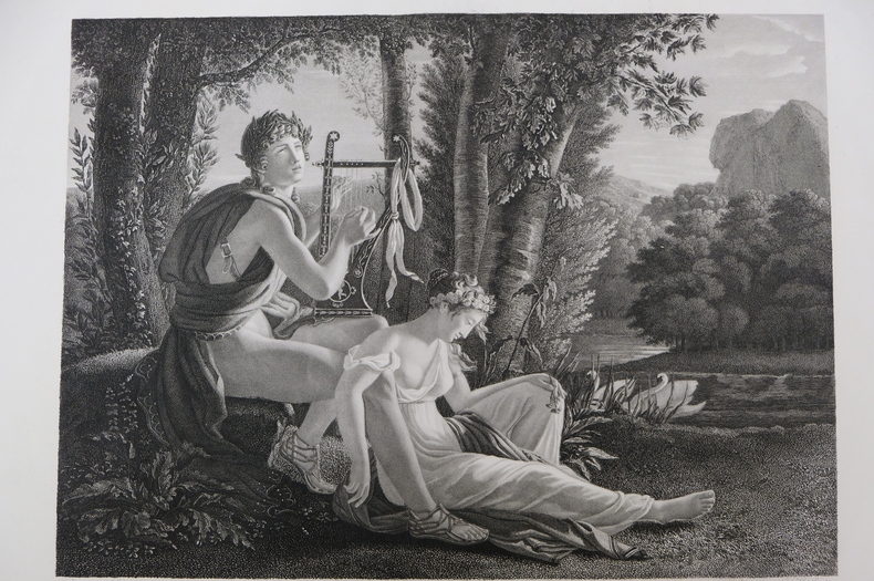
est164t3Dimension extérieur 44,5 x 55,5 cm, cuvette 43 x 53,5 cm. Très belle gravure, d'après Jean-Louis Ducis (1775-1847) et gravée par Jean Marie Gudin (1782-18..), représentant Orphée et Eurydice. En excellent état, épreuve réalisée peu de temps après le tableau de Ducis (1826).
est165t3Dimension extérieur 44,5 x 55 cm, cuvette 42,5 x 53 cm. Très belle gravure, d'après Jean-Louis Ducis (1775-1847) et gravée par Jean Marie Gudin, représentant le mythe de Boutadès, raconté par Pline qui dit que Callirrhoé avait imaginé de tracer l'ombre de son amant au charbon sur une pierre. En excellent état, épreuve réalisée peu de temps après le tableau de Ducis (1826).
Frontespizio allegorico del L’Italia a cura di Fabio Magini, edito a Bologna nel 1620, tre anni dopo la prematura morte del padre. Inciso da Oliviero Gatti. Composto da un breve testo descrittivo di sole 24 carte, l’opera è corredata di 61 carte geografiche della penisola, e costituisce il primo esempio di atlante italiano. L’opera è per intero di mano del Magini, che iniziò la realizzazione delle carte nel 1594 circa, dando alla luce per prima nel 1595 la carta del territorio di Bologna. Tutte le carte vennero alle stampe quindi prima del 1620, nelle loro stesure provvisorie, successivamente corrette ed aggiornate per l’edizione definitiva. Per la realizzazione delle lastre il Magini si servì di due dei più famosi intagliatori dell’epoca: il belga Arnoldo Arnoldi e l’inglese Benjamin Wright. Decorative titlepage of L'Italia edited by Fabio Magini, published in Bologna in 1620, three years after the untimely death of his father. Composed of a short descriptive text of only 24 pages, the work is accompanied by 61 maps of the peninsula, and is the first example of an Italian atlas. The work is entirely by the hand of Giovanni Antonio Magini, who began the realization of the maps in 1594 or so; the first dated map (1595) the map of the territory of Bologna. All the maps were printed before 1620, in their provisional drafts, later corrected and updated for the final edition. For the realization of the plates Magini used two of the most famous engravers of the time: the Belgian Arnoldo Arnoldi and the English Benjamin Wright. Copperplate, in good condition.
Frontespizio decorativo con titolo e dedica da L’Italia a cura di Fabio Magini, edito a Bologna nel 1620, tre anni dopo la prematura morte del padre. Composto da un breve testo descrittivo di sole 24 carte, l’opera è corredata di 61 carte geografiche della penisola, e costituisce il primo esempio di atlante italiano. L’opera è per intero di mano del Magini, che iniziò la realizzazione delle carte nel 1594 circa, dando alla luce per prima nel 1595 la carta del territorio di Bologna. Tutte le carte vennero alle stampe quindi prima del 1620, nelle loro stesure provvisorie, successivamente corrette ed aggiornate per l’edizione definitiva. Per la realizzazione delle lastre il Magini si servì di due dei più famosi intagliatori dell’epoca: il belga Arnoldo Arnoldi e l’inglese Benjamin Wright. Incisione in rame, bella coloritura coeva, in ottimo stato di conservazione. Decorative allegoric titlepage of from L'Italia edited by Fabio Magini, published in Bologna in 1620, three years after the untimely death of his father. Composed of a short descriptive text of only 24 pages, the work is accompanied by 61 maps of the peninsula, and is the first example of an Italian atlas. The work is entirely by the hand of Giovanni Antonio Magini, who began the realization of the maps in 1594 or so; the first dated map (1595) the map of the territory of Bologna. All the maps were printed before 1620, in their provisional drafts, later corrected and updated for the final edition. For the realization of the plates Magini used two of the most famous engravers of the time: the Belgian Arnoldo Arnoldi and the English Benjamin Wright. Copperplate with fine original hand colour, very good condition.
Ritratto di Giovanni Antonio Magini.La didascalia in basso recita: All'Ill.mo Sig.re Padrone mio Collendiss.mo il Signor Ferdinando Riario Senatore di Bologna, Nobile Venetiano, Marchese di Castiglione di Valle d'Orcia, e Cameriero della Chiave d'Oro della Maestà Cesarea Ferdinando Secondo Imperatore. Giovanni Antonio Magini's portrait.In the caption on the bottom: All'Ill.mo Sig.re Padrone mio Collendiss.mo il Signor Ferdinando Riario Senatore di Bologna, Nobile Venetiano, Marchese di Castiglione di Valle d'Orcia, e Cameriero della Chiave d'Oro della Maestà Cesarea Ferdinando Secondo Imperatore.
180519625Leipzig, Leo, (1805). 232 (recte 132) SS., 33 Kupfertafeln von P. J. Laminit, T. J. Richter und Schnorr-Gründer. Kl.-8°, zeitgen. rote Pappe, etw. Rückenvergoldung, doppelte Deckelfilten, Goldschnitt, grüne Vorsätze, im grünen Pappschuber, dieser stärker berieben und bestoßen. Der Einband an den Ecken und Kapitalen berieben.
Frontespizio inserito nel famoso itinerario del Lonschoten, edizione del 1638 curata da Evert Cloppenburgh. Incisione in rame, rifilata al margin destro, per il resto ottime condizioni. Title page of the famous Itinerario, voyage ofte schipvaert van J.H. van Linschoten naar Oost ofte Portugaels Indien. This plate appeared in Linschoten's book in 1596, once he came back from the Indies. The engraver for this map was Baptista van Doetechum. Published by Cloppenburgh in 1638. Trimmed al the right edge, otherwise good conditions. Schilder, Gunter, Monumenta Cartographica Neerlandica, vol VII.
17292158Regensburg, Lang, 1729. Siehe Lentner 10020; Pfister 572. - Das Blatt bildet das doppelblattgroße schöne allegorische Frontispiz, mit barockem Dekor, im Hintergrund die Ansicht von Regensburg.
Frontespizio del Theatrvm statvvm regiæ celsitvdinis Sabavdiæ dvcis, Pedemontii principis, Cypri regis pubblicato per la prima volta ad Amsterdam Amstelodami, apud. hæredes Ioannis Blaev, 1682. L’opera venne successivamente ristampata da Pierre Mortier. Acquaforte, in ottimo stato di conservazione. Title page of Theatrvm statvvm regiæ celsitvdinis Sabavdiæ dvcis, Pedemontii principis, Cypri regis first published in Amstelodami, apud. hæredes Ioannis Blaev, 1682. The work was later reprinted by Pierre Mortier. Etching, in excellent condition.