335 résultats
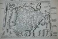
159616119Venice:: Giovanni Magini 1596-1598. Map 5 x 6.75 inches on 11.5 x 8 inch leaf. Single leaf from Giovanni Maginis Geographicae Ptolemaei 1597-1598. Revised edition of Ptolemys Geography. Copperplate engraved map of Asia. Latin text to map. Italian text to recto and verso of leaf. Large initial L below map. Engraved by Girolamo Porro. A fine impression. Scarce. Most suitable for framing. Map is 5 x 6.75 inches on leaf at 11.5 x 8 inches. Giovanni Antonio Magini 1555-1617 Italian astronomer astrologer cartographer and mathematician. Girolamo Porro 1520-1604 famous Italian engraver on wood and on copper. Maginis Geographia was first published in 1596 Latin and in 1597 & 1598 in Italian. The maps detailed and extremely attractive were engraved by the famous Porro. Authorities generally believe that they are the finest of the small size Ptolemies following those by Gastaldi done earlier. [Giovanni Magini,] unknown
1956DL1160Louvain:: Bibliotheque de l'Universite Bureaux de Recueil 1956. 1956. Series: Universite de Louvain Recueil de Travaux d'Histoire et de Philologie 4th ser. fasc. 8. First edition. 8vo. 131 358 pp. 100 figs. Original printed wrappers. Ownership ink signature of David C. Lindberg. Very good. Bibliotheque de l'Universite Bureaux de Recueil, 1956. unknown
34705Leipzig B. G. Teubner 1963. Volume I: xxxi 461pp. ; Volume II: vi 446pp. Original cloth in dustwrapper worn on both volumes although the wrapper of volume I is significantly more worn than volume II. Numerous in-text diagrams and charts. The reverse endpaper of Volume I contains a loose constallations chart. A very good copy. German language text Leipzig, B. G. Teubner, 1963 hardcover
167514546Paris, Guillaume Desprez, 1675 ; in-16 ; plein veau havane granité, dos à nerfs décoré et doré, titre doré, roulette sur les coupes (reliure de l'époque) ; (36) (titre, Epistre, Préface et Table), 457 pp., (1) p. de Privilège, 59 figures et schémas dont 13 hors-texte.
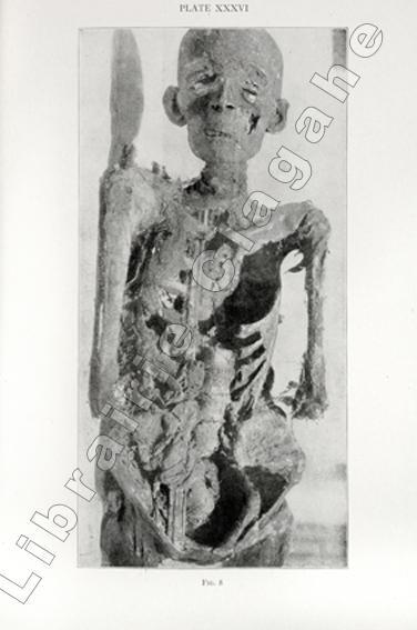
18329Edited by Roy L. Moodie. Chicago, Illinois, University of Chicago Press, 1921 ; in-8, cartonnage d’éditeur de percaline vert foncé, titre doré au dos, XX, 372 pp., photographie assis en frontispice et 71 planches hors-texte dont 8 en couleurs.
151354087Strasbourg. 1513. Originalt tresnitt. Arkets størrelse : 60 cm X 425 cm. Norsk. <br/><br/><em>“Martin Waldseemüller a highly accomplished scholar of geography merged the science of mapmaking and the art of printing in his 1513 atlas one of the most groundbraking documents in the history of cartography. He intended this atlas as a new edition of Ptolemy’s Geographia but included the addition of 20 modern maps which were not based upon the tradition of Ptolemy. Waldseemüller’s use of a quadratic plane projection was also a noteworthy advance.â€Martin Waldseemüller 1470-1520.Liten rift ved nedre marg. Et lite ormehull i venstre marg. Et par slitasjer i øvre marg. </em> unknown
152556635Strasbourg. 1525. Originalt tresnitt. Arkets størrelse : 535 cm X 395 cm. Latin. <br/><br/><em>Latinsk tekst. Bretten noe gulnet et par brunpletter.Med Kypros.Map of Palestine Mesopotamia and Babylonia in present day Middle East.Relief shown pictorially.Includes names of places and natural features.Descriptive text within ornamental borders on verso.Appears in the author's Geographia translated by Willibald Pirckheimer with annotations by Joannes Regiomontanus. Argentoragi i.e. Strasbourg : Iohannes Grieningerus communibus Iohannis Koberger impensis excudebat anno a Christi Natiuitate 1525 tertio Kalendas Apriles. Boston Public Library. </em> unknown
105903Lutetiæ Apud Gulielmum Cauellat 1556. 8 76 leaves. Illustrated with geometrical figures in the text. Contemporary vellum. Rebacked. Name erased from title-page. Occasional light foxing. . hardcover
157418848Venetia (Venice), Giordano Ziletti, 1574-(73). 4to. Hcalf from ab 1820. Gilt back. Slight rubbing to spine. (78),350 pp. and 65 double-page engraved maps with text on verso of plates (130) pp,56,65 pp. 6 textlvs. at end with brownspots in right margin, sometimes a little browning to pages, few brownspots and a few textlvs. with minor wormtracts. Complete with all 65 maps called for, each measuring ab. 19 x 26 cm. A great part of the maps have some background shadowing from the printers ink, mainly due to the fact, that this is the third Ruscelli-edition, where the plates have been used before. 3 printer's wood-cut devices and 20 smaller and larger woodcuts in the text. 2 woodcuts with Ptolemy shown observing.
50 p. Petite déchirure à la couverture, coins de la couverture pliés. Inv. 25385