Antiquariat.de

610 résultats
1914A111-101Wien, Kaiserlich-K?nigliches Milit?r-Geographisches Institut, 1914. 3. Ausgabe, Hochformat, ca. 42 x 55 cm, Ausgabe: mehrf?rbig; Zustand: gut +
1915A111-113Wien, Kaiserlich-K?nigliches Milit?r-Geographisches Institut, 1915. 2. Ausgabe, Hochformat, ca. 42 x 55 cm, Ausgabe: mehrf?rbig; Zustand: gut +
Cover portrait of King Alexander, Constantine's Second Son and Successro. Abundantly illustrated with black and white photos. Contents: effect of the 'Battle of Athens", December 1916; Exposure of Constantine's hostility to the entente; The history of modern Greece; entente doubts and difficulties; position of Italy; Exchange of Notes; Effect of Russian Revolution and American Intervention; The Thessalian Crops; Entente Discussions; M. Jonnart appointed High Commissioner; Adbication of King Constantine; The New King, Alexander; Constantine's departure from Greece; M. Venizelos becomes Prime Minister; Persecution and massacres of Greeks in Turkey and Macedonia. Contents also discuss 'Care of Disabled British Soldiers'. Topics include: Pioneer work in France; Science of orthopaedics; Sir Robert Jones's work at Liverpool; Restoration of Function; Nerve Sutures; Muscles, Tendons and Bones; Sliding Splints; Shepherd's Bush; Curative Workshops; Training for Trades and Professions; Limbless Soldiers; Roehampton; Erskine House, Glasgow; Surgery and Disfigurements; The Blind; St. Dunstan's; Nervous Disease; The Star and Garter, Richmond; A Catechism for the Disabled. Average wear. Unmarked. Sound copy. It is suggested that this issue be read in conjunction with the following issues: Part 21 - The 1st Austrian Invasion of Serbia; Part 28 - The Intervention of Turkey; Part 36 - The 2nd and 3rd Austrian Invasions of Serbia; Part 88 - The Tragedy of Serbia; Part 144 - The Salonika Expedition, Oct. 1915-Nov. 1916; Part 165 - Greece and the War, 1914-1916. Magazine
2011ART7405MSomogy, Louvre éditions, 2011. Fort In-4, relié, 727 pp. Nombreuses illustrations.
Very Good Turkish, Ottoman (1500-1928) Original color map on cloth. A little foxing on cloth. Very good. Folded. Oblong atlas folio. (66 x 72 cm). In Ottoman script. Scale: 1/210.000. Ottoman sanjaks in Albania, Macedonia and Greece. A rare Ottoman map of Balkans with Turkish place names for the period of pre-Balkan Wars, (1912-1913). Very important for onomastics and historical geography.
Very Good Turkish, Ottoman (1500-1928) Original color map on cloth. A little foxing on cloth. Very good. Folded. Oblong atlas folio. (66 x 72 cm). In Ottoman script. Scale: 1/210.000. Ottoman sanjaks in Balkans, Bulgaria. A very detailed map of Old Zagora. A rare Ottoman map of Balkans with Turkish place names for the period of pre-Balkan Wars, (1912-1913). Very important for onomastics and historical geography. Extremely rare.
Very Good Turkish, Ottoman (1500-1928) Original color map on cloth. A little foxing on cloth. Very good. Folded. Oblong atlas folio. (66 x 72 cm). In Ottoman script. Scale: 1/210.000. Ottoman sanjaks in Balkans, Bulgaria. A very detailed map of Plovdiv and Haskovo. A rare Ottoman map of Balkans with Turkish place names for the period of pre-Balkan Wars, (1912-1913). Very important for onomastics and historical geography. Extremely rare.
Very Good Turkish, Ottoman (1500-1928) Original color map on cloth. A little foxing on cloth. Very good. Folded. Oblong atlas folio. (66 x 72 cm). In Ottoman script. Scale: 1/210.000. Ottoman sanjaks in Balkans, Bulgaria. A very detailed map of Plovdiv. A rare Ottoman map of Balkans with Turkish place names for the period of pre-Balkan Wars, (1912-1913). Very important for onomastics and historical geography. Extremely rare.
Very Good Turkish, Ottoman (1500-1928) Original color map on cloth. A little foxing on cloth. Very good. Folded. Oblong atlas folio. (66 x 72 cm). In Ottoman script. Scale: 1/210.000. Ottoman sanjaks in Balkans, Macedonia. A very detailed map of Old Zagora. A rare Ottoman map of Balkans with Turkish place names for the period of pre-Balkan Wars, (1912-1913). Very important for onomastics and historical geography. Extremely rare.
Very Good French Original b/w map. Oblong: 57x66 cm. In French. Folded. It includes for pieces: Title, structure physique de la region, Thessalie and main part which shows the area from Ohrida Lake on the west to Golf of Thessaloniki on the east. [MAP] Mission antipaludique de l'Armee d'Orient: Carte des indices endemiques Macedoine, Thessalie, Serbie meridionale, confins albanais 1917 et 1918.
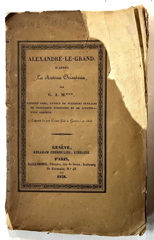
1828136738Genève, Paris, Abraham Cherbuliez, Ballimore 1828 In-8 22 x 14 cm. Broché, couverture marron, titre en noir sur le dos et le premier plat de couverture, VIII-138 pp. Manque angulaire en couverture.
Very Good Turkish, Ottoman (1500-1928) Original color map on cloth. Oblong atlas folio. (49 x 60 cm). Toponyms in Turkish with Arabic letters. In Ottoman script. Scale: 1/25.000. [MAP of ISTANBUL / CONSTANTINOPLE] Küçükköy, Petnahor, Makriköy, Kagidhane [Kagithane]. A rare Istanbul map including some old Byzantine toponyms.
Minor edgewear/rubbing to boards. Light shelfwear. Corners a bit rounded. Spine slightly sunned with light spotting. ; Looks at the military and political career of Aratos of Sicyon. ; Thiriwall Prize Essay 1933; 222 pages
Very Good German Original color map on cloth. Chipped on folded places. Otherwise a clean copy. Oblong atlas folio. (46 x 52 cm). Scale: 1/300.000. Toponyms in German. Shows Gallipoli [and the Hellespont, Edremid Gulf, Imbros, Tenedos, Lesbos (Midilli), Aivali (Ayvalik) and North Aegean shores of Anatolia]. A sheet of the collection of 'The general map of Central Europe'. appeared in the years between 1873-1876 with the work of Joseph Ritter von Scheda, (1815-1888) who was a general, geographer and cartographer.
Carta geografica della Macedonia, in bella coloritura coeva. Inserita in "Mercurio geografico overo Guida Geografica in tutte le parti del Mondo conforme le Tavole Geografiche del Sansone Baudran de Cantelli Data in luce con direttione, e cura di Gio. Giacomo de Rossi nella sua stamperia in Roma alla Pace all'insegna di Parigi con Priu: del S. Pont" edita a Roma alla fine del '600. La carta presenta un restauro conservativo nel Golfo di Salonicco e due arrossature agli angoli in basso
Ex-library copy with usual stamps, call numbers and pocket. Minor shelfwear. ; Deals with the development of the Macedonian State and the struggle for survival as well as the Reign of Philip the Second. Includes 10 maps, 3 plates. ; Volume 2 Only; 780 pages
Very Good Latin Original map. Oblong 4to. (25 x 34,5 cm). In Latin. From 'Mercator Atlas'. A very good copy. A detailed and decorative engraved map. B/w. Including Europae Pars (Thrace) and Black Sea, Aegean and Mediterranean, and with all ancient toponyms and names of regions including Cyprus and Syriae (Syria). Could not be find map-maker and being from which book. An early and decorative map of Asia Minor.
BN264757Made in Italy <br/><br/>Made in Italy Manuela Macedonia unknown
Very Good Turkish Original manuscript map of Alexandria Port and its immediate hinterland. Folio. (33 x 41 cm). In Turkish (Modern). Folded. No scale. The manuscript shows Alexandria Port and the Palace of the King Farouk of Egypt, customs shores, ports and harbors, locations of the British ships, radio station, location of SS Ramlah, strait, Great Pass (?), waterfront for the lumber ships, sea current zones and probably entrance and exit routes etc. A very detailed map, decorated with ships. Some repairs with tape, tears, foxing and stains. Overall a good copy.
Very Good Turkish, Ottoman (1500-1928) Original color map on cloth. Oblong atlas folio. (44 x 58 cm). Scale: 1/200.000. Toponyms in Ottoman script /Turkish with Arabic letters). Shows southwest of the Gallipoli Peninsula [and the Hellespont], Edremid Gulf, Tenedos, and North Aegean shores of Anatolia]. Folded. This is one of the series of the Bonn projection maps which are the first map series in modern techniques in Turkey and the Ottoman Empire. In order to produce these maps covering Turkish territory, Reconnaissance Branch was incorporated into The Mapping Commission. The maps were produced in the datum based on the latitude and longitude of the Ayasofya Mosque in equal area Bonn Projection. The field works for the 123 sheets covering the country were conducted by 76 staff. The production was completed in 18 years starting from east-west. Fieldworks continued without stopping except in the years 1914 and 1920. This map series called also reconnaissance maps contributed a lot to producing 1:25.000 scale maps. Hegira: 1336 = Gregorian: 1920. Not description on map-maker. Extremely rare.
Very Good Turkish, Ottoman (1500-1928) Original chromolithograph folded map. Oblong atlas folio. (49 x 65 cm). In Ottoman script. Repaired with a band in the contemporary period from its backside. Set including 4 sheets. Other sheets are Basrah, Bagdad, and Qut al-Amare. This is the first sheet including 'Samawah'. Rare. Scale is 1/500.000. Samawah city was settled by the Arab tribe of Banu Quda'a around the 3rd century AD. It is built on both sides of the Euphrates river; there are four bridges in the center of town for crossing between the two sides. The west bank of the city contains the commercial heart of the city and includes the old town and the Jewish quarter, Agd al Yahood. The west bank is the site of the covered market Suq Al Masgoof, which dates to the Ottoman period. The area surrounding the market is the old city with its Byzantine maze of crowded markets and streets. The eastern side of the city including 'Qushla' has a more modern feel and contains a number of estates of apartment blocks built during the 1970s and 1980s, As Samawah Stadium, which is home to the local Muthanna football team Samawa FC, as well as technical colleges and the polytechnic. There too is Al Qushla, the historic "Ottoman Barracks". The most famous attraction of Samawah in the ruins of the ancient Sumerian city of Uruk which dates to 4000 BC. This was the largest city in Sumer, extending over 2 km2. Uruk was not only the largest conurbation of the first urban civilization on earth, but it is also the place where the first written script was discovered, the oldest dating back to 3300 BC. The palm groves of Samawah: Samawah is built on both sides of the Euphrates and is surrounded by hundreds of palm groves that give it a tropical feel, especially in the southern and northern suburbs. These groves provide cool respite from the scorching heat of Mesopotamia and were the inspiration for the famous Iraqi folk song "The Palm of Samawah".
Very Good Turkish, Ottoman (1500-1928) Original map of Kars Fortress. Oblong: 45x57 cm. In Ottoman script. Scale: 1/21000. [PLAN OF KARS FORTRESS] Kars Kal'asi plâni (Based on 1898 discoveries and 1908 practice). A very detailed plan in Ottoman script of Kars Fortress and is environment. Some red markings. Extremely rare.
Very Good English Original b/w portolan chart. Folded. A little foxing and some pencil markings and notes in Ottoman script in its period. Oblong double elephant folio. (70 x 102 cm). In English. Bosphorus to Kerempeh from the Russian survey of 1834 with additions and corrections by Commander W. J. L. Wharton., R. N. 1872-80. It's written 'London published according to Act of Parliament at the Hydrographic Office of the Admiralty Jare. 16th 1854. Also shows Killa Bay (Shile Bay) from a survey by Lieut. Comm. W. R. Pristen and the midshipmen of H. M. S. Royal Sovereign, 1920. Topography partly from a Turkish map. Up side of map, engraved a view from sea of entrance of the Bosphorus, Rumili (sic. Rumeli) Lighthouse and environment with several hills. And also shows Amastra (Ancient Amastris) from Russian surveys, 1834-41; Kosku Bay from a surbey by Capt. Spratt R. N. 1854; and Sungul Bay (Zonguldak) from the Heraclee Companys plans to 1915. A rare navigation chart.
Large format beautifully illustrated book about the treasures of the Archaeological Museum of Thessaloniki. 378p. This extremely large [14x11x4 inches - 35x28x4cm] and heavy volume weighs. 3.5 kg.- almost 8 lbs [7 Copies found WorldCat] Book
1708GRA241Paris 1708. Carte gravee sur cuivre, contours colories, 47 x 66 la plaque, avec marges. La partie nord de la Grece avec une partie des Balkans.