CHATELAIN, Henri AbrahamBiblio.com

399 résultats
1710536431710. A beautiful map of the northern part of European Russia from 58 degrees Saint Petersburg northwards to the arctic coast. The map shows the different provinces rivers forests and towns. Copper engraving. Good margins closed tear at right margin expertly repaired. Very good condition. Later colour. Size: 45 x 35 cm. 17½ x 14 inches unknown
172053003c.1720. Interesting plate with two maps side by side - 1. Scotland 2. England and Wales with a list of the principal battles in England two coats of arms of England and Scotland. The chart is the left half of a larger chart but with the maps of England and Scotland at the centre makes an attractive chart by itself. Copper engraving. Very good condition. Waterstain on lower and left hand edge not affectingand well clear of the map Later colouring. Size: 44 x 37.5 cm. 17½ x 15 inches. unknown
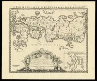
171915847Amsterdam: François L'Honoré & Compagnie Libraries 1719. 440 by 520mm. 17.25 by 20.5 inches. Engraved map. Henri Chatelain's edition of Adrien Reland's important map of Japan 1715 including the place-names in phonetic Dutch. Reland's map of Japan represents a radical departure from prior European maps of Japan and is the first map printed in Japan to use Sino-Japanese characters. Instead of using the existing European geographical sources of Japan Reland utilized Japanese maps most notably a map from the library of Benjamin Dutry 1668-1751 a former director of the Dutch VOC. This was a tremendous leap forward in the geographical depiction of Japan such as in the treatment of Kyushu Island and in naming the 66 provinces. Large inset of the area around Nagasaki and an ornate dedication cartouche with about twenty coats of arms. Published in the fifth volume of the Châtelain family's 'Atlas historique ou Nouvelle introduction à l'Histoire à la Chronologie & à la Géographie Ancienne et Moderne ' 1719 when eventually extended to 7 volumes. With an inset 'Vue de la Ville de Nangasacki & de l'ile'. Zacharie Châtelain d. 1723 was the father of Henri Abraham 1684-1743 and Zacharie Junior 1690-1754. They worked as a partnership publishing the 'Atlas ' under several different Châtelain imprints depending on the Châtelain family partnerships at the time of publication. The atlas was published in seven volumes between 1705 and 1720 with a second edition appearing in 1732. The maps were accompanied by information pertaining to cosmography geography history chronology genealogy topography heraldry and costume of the world. The maps in the "Atlas Historique" were mainly based on those of the French cartographer Guillaume De L'Isle but were presented by the Châtelains in an encyclopaedia form. The accompanying text is in French and often is printed in two columns on the page with maps and other illustrations interspersed. Each map and table is numbered consecutively within its volume and all maps bear the privileges of the States of Holland and West-Friesland. Hubbard 73. François L'Honoré & Compagnie Libraries, unknown
1730320794Amsterdam: Henri Abraham Chatelain 1730. unbound. View. Uncolored engraving. Image measures 12" x 21.5". Handsome antique brown frame 18 3/4 x 21" not examined out of frame.<br/> <br/> This striking view by Henri Abraham Chatelain depicts the interior of the temple of Mecca. Features the interior prayer scene of the temple with a key below the map noting the locations mapped on the map. Issued in the 1730 edition of Chatelain's "Atlas Historique" one of the most widely distributed and lavishly illustrated work of its kind in the 18th century. Henri Abraham Chatelain 1684 - 1743 was a Dutch cartographer pastor best known for his seminal seven volume "Atlas Historique". This is a beautiful example of his work.<br/> <br/> Henri Abraham Chatelain unknown
170516453Amsterdam 1705. Unusual double-hemisphere map of the world illustrating the success of the Dutch East and West India Companies throughout the world. With text above and below sailing ships lions and the figure of Europa seated inside a native fort. Showing California as an island incomplete Australia and New Zealand and the west coast of America extending toward Asia. From Chatelain's 'Atlas Historique'. Uncolored . Image size: 18 x 13". References: MCC 2 Tooley - Antarctica #54. Very good. unknown
171025803Amsterdam 1710. Copper-engraved map period hand-colouring in outline. Tables upper left and along the right side. Attractive map of North America based upon De L'Isle's highly influential map of North America published in 1700.<br/> <br/> By combining a wealth of information and geographical observation with delicate engraving and an uncomplicated composition this elegant map is a superb example from the golden age of French mapmaking and was published in Chatelain's Atlas Historique an important encyclopaedic historical atlas. California is shown as a peninsula with a number of villages and mountains; the Mississippi River extends far north of its true source. The table along the right side details the various native tribes from each region with lettered references for locating on the map.<br/> <br/> Lowery 263; Phillips 579. unknown
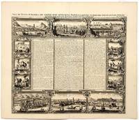
172053014Amsterdam. c.1720. This fascinating engraving has three views of St. Kitt's above texts in French about St Kitts and the province of Bemarin at centre and below there are three prints of fishes birds and insects of the island. Title on top edge. Chatelain's Atlas Historique in seven volumes half atlas and half encyclopaedia was a massive and important work of its time. From the Atlas Historique. Copper engraving. Fine condition Uncoloured. Size: 48 x 37 cm. unknown
17209662Amsterdam 1720. Copper engraving 34 x 44 cm black and white trivial toning at centrefold blank verso. This early modern conception of ancient Rome published in Chatelains encyclopedic Atlas Historique and derived from Ambrogio Brambillas map of 1582 includes imaginative reconstructions of 152 principal monuments and public buildings numbered and identified in the legend with no attempt to sketch or suggest the intervening private buildings. Map unknown
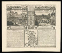
171915864Amsterdam: François L'Honoré & Compagnie Libraries 1719. 441 by 515mm. 17.25 by 20.25 inches. Engraved spread with family tree two scenes text and inset map. With an inset of Japan 'Carte du Japon'. Published in the fifth volume of the Chatelain family's 'Atlas historique ou Nouvelle introduction à l'Histoire à la Chronologie & à la Géographie Ancienne et Moderne ' 1719 when eventually extended to 7 volumes. The vignette map is a more traditional representation of Japan than the other that appears in the 'Atlas'. It was probably borrowed from Pieter van der Aa who in turn drew on Sanson's model of 1652. It appears between two large text panels one concerning the death of the Emperor of Japan the other with the Dutch 'Embassy' there in 1644. Zacharie Chatelain d. 1723 was the father of Henri Abraham 1684-1743 and Zacharie Junior 1690-1754. They worked as a partnership publishing the 'Atlas ' under several different Chatelain imprints depending on the Chatelain family partnerships at the time of publication. The atlas was published in seven volumes between 1705 and 1720 with a second edition appearing in 1732. The maps were accompanied by information pertaining to cosmography geography history chronology genealogy topography heraldry and costume of the world. The maps in the "Atlas Historique" were mainly based on those of the French cartographer Guillaume De L'Isle but were presented by the Chatelains in an encyclopaedia form. The accompanying text is in French and often is printed in two columns on the page with maps and other illustrations interspersed. Each map and table is numbered consecutively within its volume and all maps bear the privileges of the States of Holland and West-Friesland. Hubbard 74. François L'Honoré & Compagnie Libraries, unknown
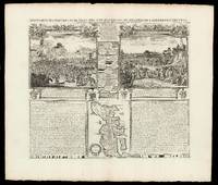
171915804Amsterdam: François L'Honoré & Compagnie Libraries 1719. 483 by 565mm. 19 by 22.25 inches. Double-page engraved map. With an inset of Japan 'Carte du Japon'. Published in the fifth volume of the Chatelain family's 'Atlas historique ou Nouvelle introduction à l'Histoire à la Chronologie & à la Géographie Ancienne et Moderne ' 1719 when eventually extended to 7 volumes. The vignette map is a more traditional representation of Japan than the other that appears in the 'Atlas'. It was probably borrowed from Pieter van der Aa who in turn drew on Sanson's model of 1652. It appears between two large text panels one concerning the death of the Emperor of Japan the other with the Dutch 'Embassy' there in 1644. Zacharie Chatelain d. 1723 was the father of Henri Abraham 1684-1743 and Zacharie Junior 1690-1754. They worked as a partnership publishing the 'Atlas ' under several different Chatelain imprints depending on the Chatelain family partnerships at the time of publication. The atlas was published in seven volumes between 1705 and 1720 with a second edition appearing in 1732. The maps were accompanied by information pertaining to cosmography geography history chronology genealogy topography heraldry and costume of the world. The maps in the "Atlas Historique" were mainly based on those of the French cartographer Guillaume De L'Isle but were presented by the Chatelains in an encyclopaedia form. The accompanying text is in French and often is printed in two columns on the page with maps and other illustrations interspersed. Each map and table is numbered consecutively within its volume and all maps bear the privileges of the States of Holland and West-Friesland. Hubbard 74. François L'Honoré & Compagnie Libraries, unknown
17055584Amsterdam c. 1705. Copper engraved title-page 40 x 24.5 cms black and white as issued blank verso. Engraved for the first volume of Chatelains historical atlas. The classical muses represent Chronology History Navigation and Geography. Atlas braces himself against a crumbling pyramid supporting the heavens while the title of the atlas is suspended on a banner borne by the winged angel of fame. Shirley Courtiers & Cannibals 75. Map unknown
17231687Paris: Châtelain 1723. Copperplate engraving on cream laid paper 15 x 17 1/4 inches 381 x 440 mm; sheet 17 1/4 x 20 1/4 inches 438 x 551 mm full margins. In good condition consistent with age and with a reinforced central crease as issued. An image from volume VI of Châtelain's monumental Atlas Historique with text by the prolific author Nicolas Gueudeville. Châtelain unknown
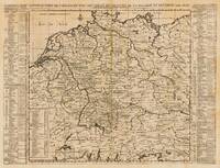
170928176Nürnberg: Henry Chatelein 1709. Other. Im unteren Mittelfalz kleiner hinterlegter Einriss ansonsten in sehr gutem Erhaltungszustand. Verso Spuren früherer Faltung vom Atlas. . 465 by 475mm 18 by 18 inches. Hand-Colored Original Copperplate Engraving by Henry Abraham Chatelein depicting Deutschland. Published Nürnberg Henry Chatelein 1709. Sheet: 465 by 475mm 18 by 18 inches. A fine and original hand-colored example of Chatelein's celebrated cartographic work documenting this region of Germany with the precision and decorative artistry characteristic of the 17000s. Henry Abraham Chatelein was a cartographer active in the 1700s working in the tradition of European copper-engraved cartography. Their maps are valued by collectors for their historical accuracy and decorative quality.This original copperplate engraving with original hand coloring depicts the region of Deutschland published in Nürnberg Henry Chatelein 1709. The map records the political and geographic boundaries of the region as understood in 1709 offering a fascinating window into the history of German territorial organization. Sheet measures 465 by 475mm 18 by 18 inches. In good condition overall with minor signs of age appropriate for a 18th-century engraving. Ready to frame. Henry Chatelein unknown
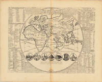
171335976Nürnberg: H. Chatelein 1713. In excellent condition. 33.5 x 445 cm 13.25 x 175 inches. Original antique copper engraving uncolored as published. Geographical map contained in Volume I "Atlas Historique ou nouvelle Introduction a l'Histoire à la Chronologie & à la Geographie Ancienne & Moderne" published in Amsterdam in 1713. Atlas which with its publication includes geographic maps with engravings and information of a geographic heraldic ethnographic and historical nature making the work in seven volumes very innovative. Engraved map of the Eastern Hemisphere with an inset of the Western Hemisphere in the center showing California as an island. Contains tables notes and 7 cartoons illustrating the 7 wonders of the world Henri Abraham Chatelain 1684 - 1743 a Huguenot pastor originally from Paris lived alternately in Paris London The Hague and Amsterdam. Known as a Dutch cartographer for his monumental seven-volume cartographic work Atlas Historique published with his brothers in Amsterdam. H. Chatelein unknown
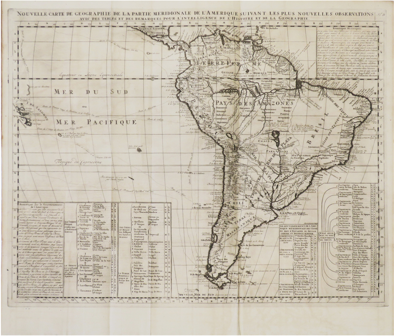
1720LBW-6083[Amsterdam, circa 1720]. 402 x 515 mm.
1720LBW-8789[Amsterdam, circa 1720]. 469 x 593 mm.
179955365Providence: printed by Brother Bennett Wheeler 1799. First edition 8vo pp. 15 1; 20th-century brown cloth-backed marbled boards gilt-lettered direct on spine; title page guarded small stain in the top gutter margin throughout; all else very good. On the verso of the last leaf: "Benjamin J. Sheffield his book bought December 23 AD 1799 price P. 4½." This discourse by a clergyman indicates the comfort of the clergy with Masonry at the turn of the century. Alden 1614; Bartlett p. 77-8; Evans 35310. <br/><br/> printed by Brother Bennett Wheeler hardcover books
1800007304Providence: John Carter Printer 1800. First Edition. Pamphlet. Good. Pamphlet lacking any wraps that may have been issued. Disbound from a larger work. First edition. 26 pp. A speech reflecting on the life and legacy of George Washington containing several lengthy quotes from Washington regarding his role as general of the American Army as well as president. With several passages of historical detail on the American Revolution including brief mention of Yorktown and Valley Forge. A footnote also contains a short genealogy of the Washington family. This speech was given to the freemason members of the Mount-Vernon Lodge as well as to St. John's Church in Providence Rhode Island on February 22nd 1800 5800. GOOD condition. Mostly minor scattered foxing minor staining and soiling. Remains of leather along the spine. Minor wrinkling. Light browning and some ghosting to the text. Evans 37189. John Carter, Printer unknown
177339528Pennsylvania: Hall and Sellers 1773. 1st printing. Buff printed paper. Expected wear to paper age-toned and faint horizontal crease. Some black ink worn to red three owner's signatures to front side. Very Good. Single sheet of paper printed both sides. Engravings to both sides of the note. 3-5/8" x 2-7/8" <br/><br/> Hall and Sellers unknown books
177928874London Printed for J. Dodsley 1779
1720910201CGAugsburg:, Jeremias Wolff, 1720. Kupferstich Blattgröße 48 x 40 cm.
170837855London: Jacob Tonson 1708. In all 36 fine engraved plates. 3 vols. 8vo. Beautifully bound in full nineteenth-century crimson crushed morocco gilt spines green leather labels marbled endpapers a.e.g. BY RIVIERE. BEAUTIFUL SET with the engraved bookplate of "John Sheepshanks 1852" in each volume. In all 36 fine engraved plates. 3 vols. 8vo. Jacob Tonson unknown books
1772007772London: Printed by W. Bowyer and J. Nichols : For T. Cadell in the Strand 1772. Two volumes Very Good Plus in contemporary full calf back with gilt devices and rules leather label with gilt lettering covers with gilt rule later end papers which are stamped S & S light toning light rubbing to edges of covers overall a quite pleasing set. With preface and notes by the editor Bishop Hurd and a life of the author by T. Sprat. . Second Edition. Full Calf. Very Good Plus/No Jacket As Issued. 12mo - over 6¾" - 7¾" tall. Printed by W. Bowyer and J. Nichols : For T. Cadell, in the Strand Hardcover books
1723AR20GLTBLK10London: Printed By A. Moore 1723. Hardback recent quarter leather marbled paper covered boards. New end-papers. 30cm x 18.5cm. Bound with a Portion of Abraham Cowley's Miscellanies - but lacking the title page for it. Pp. iv 30 17 41. Decorative initials and headpieces. 2nd edition 1723. A couple of small marks to final page 41. Scarce. ar20. 2nd Edition. Hard Cover. Very Good. Printed By A. Moore Hardcover