Ortelius, AbrahamBiblio.com
23 962 résultats
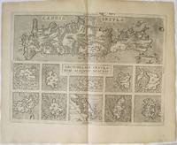
2520Greece: Antverpiæ"/Antwerp. "ex Officiana Plantiana" . Plantijn Christoffel. 1592-95. Copper engraved map of Crete and Islands of the Archipelago from Ortelius' "Theatrum Orbis Terrarum" 1595 edition; black & white. Latin text to verso. In the upper half of the map is Crete with the small islands of" Falconera "& "Plana"added in the top border ; below 10 small maps of : Mytilene Kythera Karpathos Naxos Santorini Milos Limnos Euboea Rhodos & Chios. Zacharakis states the the map is a variant second state between 1592 & 1595 not only the the islands in the border but also newly added are the islands of "Dionysiades Cazucaci Amarti & Caxio" and various names in the centre of the island: Messarea Cadra Carum Belveder and Casali. Good dark impression; clean and bright tiny pin prick wormhole by "Falconera". Abraham Ortelius 1527-1598 Flemish Cartographer . produced the first modern Atlas "Theatrum Orbis Terrarum" in 1570. printed by Aegidus Coppen Diest. There were numerous editions thereafter with texts in various languages; the printing of such was taken over by Chrstoffel Plantijn in 1579 . Ortelius himself drew all the maps in manuscript before passing them to the printers. there is conjecture that he may have engraved some of the plates as well The 1595 Latin text edition is the most complete produced during his lifetime containing all the maps of the 1593 edition plus those of the the"Additamentum" and the"Pareragon" or Ancient geography. The " Additamenta" were supplements to the original Atlas; at the same time Ortelius replaced some maps with new ones showing the same place; some plates were also reworked . Ortelius was Geographer Royal To Phillip II of Spain from 1575. He also worked closely with Braun & Hogenburg on the "Civitas Orbis Terarum". After his death the plates were purchased by Jan Baptiste Vrients in 1601 who published further editions until 1612. Van de Krogt :3; .Koeman: Ort29 8998 Zacherakis: 2497; van den Broecke:147a. Greece Crete Candia Archipelago Mytilene Kythera Karpathos Naxos Santorini Milos Limnos Euboea Rhodos Chios Antverpiæ"/Antwerp.. "ex Officiana Plantiana" . Plantijn Christoffel.. 1592-95 unknown
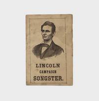
1864377694Philadelphia: Published by Mason & Co 1864. 16pp. 16mo. Publisher's wrappers with a portrait of Lincoln on the front and advertisements for political emblems badges pins etc. on the verso. Minor staining. Housed in a morocco backed slipcase. 16pp. 16mo. A pocket songster printed to support Lincoln's reelection campaign in 1864 featuring a rather youthful portrait of the president on the front wrapper and twelve spirited pro-Union songs. The titles largely military in theme include such works as "Give us Noble Leaders" "The Veteran Volunteer" "Cast Your Votes for Abraham" "For Lincoln or McClellan you'll be called on to decide/ The one to save the union the other to divide" and "We are Coming Father Abraham 600000 More." <br /> <br /> The advertisements on the rear wrapper encourage readers to purchase a wide variety of Lincoln campaign badges emblems pins and photographs from the publishers. Despite Lincoln's overwhelming electoral victory in 1864 the race was rather close in Pennsylvania where this was printed - Lincoln took Philadelphia County by a scant few percent and actually failed to secure a majority in neighboring Montgomery and Bucks counties. Monaghan 323; Abraham Lincoln: His Life in Print p. 199 Published by Mason & Co unknown
1864101729Np New York: For sale by all News Agents. Price $1 per 100. 1864. 4to. Broadside text in two columns; creased from prior folding and split at creases some toning and paper clip rust staining. Republic campaign broadside reprinting an interview with Lincoln by former Wisconsin State Assemblyman Joseph T. Mills and former state Governor Alexander Williams Randall. Lincoln vigorously defends the use of Black soldiers in the Union Army against Democratic candidate McClellan's strategy of leniency towards Southern States rejoining the Union: "The slightest knowledge of Arithmetic will prove to any man that the rebel armies cannot be destroyed with Democratic strategy. It would sacrifice all the white men of the North to do it. There are now in the service of the United States near 200000 able-bodied colored men most of them under arms defending and acquiring Union territory. The Democratic strategy demands that these forces be disbanded and that the masters be conciliated by restoring them to slavery. Will you give our enemies such military advantages. to get them back into the Union Abandon all the posts now garrisoned by black men take 200000 men from our side and put them in the battle-field or corn-field against us and we would be compelled to abandon the war in three weeks. . There have been men base enough to propose to me to return to slavery the black warriors of Port Hudson and Olustee and thus win the respect of the masters they fought. Should I do so I should deserve to be damned in time and eternity. My enemies pretend I am now carrying on this war for the sole purpose of abolition. So long as I am president it shall be carried on for the sole purpose of restoring the Union. But no human power can subdue this Rebellion without the use of the emancipation policy and every other policy calculated to weaken the moral and physical forces of the Rebellion." This is the first separate printing of the interview which was first published as "The Loyal Road to Peace and the Disloyal Road to Ruin President Lincoln on Democratic Strategy" in the Wisconsin Grant County Herald August 1864. The broadside also prints Grant's letter to E.B. Washbourne "The Rebels have now in their ranks their last man. The little boys and old men are guarding prisoners guarding railroad bridges and forming a good part of their garrisons for entrenched positions " and a poem by Bayard Taylor on the Democrats' presidential nominating convention. REFERENCE: Sabin 41157; Weinstein Against the Tide 141 For sale by all News Agents. Price, $1 per 100. unknown
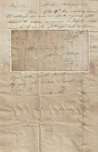
1819010456St. Louis Missouri 1819. Envelope or Cover. Very good. This stampless folded letter measures 7.5†x 12â€. It is datelined “St. Louis 14 August 1819†and was sent to Moses Taylor at Mount Vernon Ohio in care of the towns postmaster Henry B. Curtis by Aaron T. Crane and Abraham Beck early St. Louis land agents whose business the Western Land Agency was located in the rear of the Bank of St. Louis at 58 South Main Street where Crane also served as the St. Louis Postmaster only the third since the position was established in 1808. The letter’s two-line typeset postmark was the earliest used in St. Louis and the Spink Shreve Auction #121 reports that only four examples are known to have survived. </p> <br /> <br /> <p>Taylor or Curtis for him apparently had asked Crane and Beck if they knew the whereabouts of a relative probably a son. It reads in part:</p> <br /> <br /> <p style="margin-left:5%; margin-right:10%;">“Yours . . . was duly received and we made immediate enquiries . . . to return an answer as soon aspossible still owing to the number of strangers who daily arrive & pass through this place we were unable to discover Mr. Taylor matching the name you provided. However a person answering your description by the name Moses Taylor a carpenter by trade is in this place. He is doing well & has been making some money & has good employment. We said nothing to Mr. Taylor yet. Yours Respectfully / Crane & A. Beckâ€</p> . No online information is available about the Ohio Turners and little is known about Crane and Beck other than that Beck was the son of a New York physician and Crane had served as an army or militia captain during the War of 1812.</p> <br /> <br /> <p>For more information see Billon’s Annals of St. Louis in its Territorial Days Heritage Auctions Sale #3547 of 1 November 2017 and Horstman’s “William T. O’Hara Missouri Territorial Banker†in the “Missouri Paper Money Clip File†at Washington University Volume 1 of the American Stampless Cover Catalog and on-line genealogical records for Crane Beck and Curtis.</p> <br /> <br /> <p>An exceptionally scarce and important letter regarding life in early American St. Louis as the city was growing rapidly. The physical records for the Western Land Agency which have been microfilmed and digitized are held by the Library of Congress. At the time of listing only one other letter from Beck held by the St. Louis Mercantile Library at the University of Missouri in St. Louis and one document signed by Crane a 6-cent Post Office scrip note are known to have survived. </p> . unknown
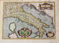
1620M10729Antwerp c.1620. Very Good. Notes: Map of Italy by Abraham Ortelius based on Gastaldi. Size : 345x480 mm 13.58x18.90 Inches Coloring: Hand Colored Reference: Van den Broecke 205 Category: Maps Europe Italy; Maps Mediterranean Islands; unknown
199347088Norwalk CT: Easton Press 1993. Ten volumes. 8vo. Approx. 4500 pp. Titles in red & black. Frontispices to each vol. numerous plates. Uniformly bound in full brown morocco elaborately gilt decorated covers spines red & gilt morocco spine labels a.e.g. silk moire endpapers Fine set. First Easton Press edition of this invaluable reference to one of our most important Presidents. The Easton includes the two supplements combined into one volume. Easton Press, unknown
15801396356c1580. Condition of map is Good with moderate age toning creasing and a small brown stain along right edge. Matted in metal frame measuring 24.25 in. x 19.75 in. . CW Consignment. Shelved at Rockville PS 1101 #25. Believed to be from Abraham Ortelius's "Theatrum Orbis Terrarum - Parergon - Nomenclator Ptolemaicus" published in Antwerp by Christoph Plantin Press 1579 1584. 1396356. Special Collections - Upstairs. unknown
1999julzSadanlaur Pubns 1999. Book. Fine. Hardcover. 1st Edition. Sadanlaur Pubns Hardcover
ANAIS-1568980493Princeton Architectural Press. paperback. Good. 1x1x1. Buy with confidence. Excellent Customer Service & Return policy. Princeton Architectural Press paperback
17452302240034Paris: Quay des Augustins chez Charles-Antoine Jombert libraire de l'Artillerie & du Genie au coin de la rue Gille-Coeur a l'Image Notre-Dame 1745. Nouvelle edition. Hardcover. Very Good. An early book on Engraving and Printing Bound in contemporary polished calf. Gilt spine compartments. Good binding and cover. All edges red. Marbled end sheets. 8vo. xxxii 186 6 pp. engraved frontispiece 19 engraved folding plates. Bookplates of noted Lebanese collector Camille Aboussouan. Enlarged updated edition first published in 1645. Cohen-de Ricci p. 177. Quay des Augustins, chez Charles-Antoine Jombert, libraire de l'Artillerie & du Genie, au coin de la rue Gille-Coeur, a hardcover
19155423Martinus Nijhoff Haag 1915; First Edition; octavo; red cloth gilt titles and decorations; illustrated. Seven matched volumes I thru VII each with index at the front and containing throughout the set 38 full-page b&w illustration plates and over 300 reproductions of the artists’ signatures. Lacks volume VIII the overall indexing register. Foremost reference source on 16th-18th century Dutch and Flemish artists painstakingly compiled and published sequentially between the years 1915-1922 by prodigy Abraham Bredius 1855-1946 director of the Mauritshuis Royal Art Gallery at the Hague from 1889-1909 and world-renowned authority on 17th century Dutch/ Flemish art. Bound in the original publisher’s red cloth boards with gilt titles and seal on the front. All volumes in Very Good Plus condition clean crisp bright bindings tight sound and square corners sharp. A legendary reference in exceptional condition. See Mary W. Chamberlin’s "Guide To Art Reference Books" and Arntzen & Rainwater’s "Guide To The Literature Of Art History" for more on this work. Ships to U.S. only. Martinus Nijhoff hardcover
043393Harrogate Tennessee: Lincoln Memorial University. Twelve clean tight blue cloth hardcovers in very good condition; lightly bumped corners and light shelf wear. No DJs as issued. NOTE: twelve volumes; no priority or overseas Amazon orders. . Very Good. Hardcover. Lincoln Memorial University hardcover
1592273298Antwerp: Abraham Ortelius 1592. unbound. Map. Uncolored engraving. Sheet measures 16" x 21".<br/> <br/> This beautiful 1588 map by Abraham Ortelius depicts Holland or the Netherlands in exceptional detail. The map covers the regions near the Wadden Sea roughly covering modern day provinces of North Holland South Holland and Utrecht. The map centered on Amsterdam is oriented with north to the left. Topographical and geographical features such as mountains and cities are beautifully rendered in profile.<br> <br> The waters surrounding the region are shown with waves and include several illustrations of ships throughout. This is the first state of the map with later states showing a stippled sea rather than waves. Includes a large strapwork title cartouche scale of miles with a divider in the lower left. The Royal coat of arms is presented in the top left. The map also includes a 16-point compass rose.<br> <br> Ortelius based this map on the work of Jacob van Daventer. Published in the 1588 edition of Ortelius' famous "Theatrum Orbis Terrarum" which is historically considered the first modern atlas. Based on the text on verso only 300 copies of this particular edition were ever printed van der Broecke 79.<br> <br> The map is in good condition with minor wear along the original centerfold. Minor foxing at places. Original plate mark is visible. Latin text on verso.<br> <br> Abraham Ortelius 1527--1598 a Flemish cartographer and geographer is widely regarded as one of the important and influential cartographers in history. He is known for his "Theatrum Orbis Terrarum" which was the first modern atlas. Hard to find in black and white.<br/> <br/> Abraham Ortelius unknown
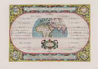
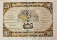
1590200018AG1590. Antwerp Ortelius 1590. Original hand-coloured engraving. Plate Size: 44 cm x 31 cm. Sheet Size: 53.7 cm x 38.5 cm. Original map. Very good actually stunning condition. Really clean and crisp. Generous margins. Reverse recto carries Latin text. Shirley 176; Broecke 186.1; Koeman III 0800H:31. Beautifully unusual and richly decorated map of the Ancient World based upon the work of Claudius Ptolemy from Ortelius' Parergon 'Supplement'. The depicted land masses of Europe Africa and western Asia are largely in their modern configurations although the place names on the map are based upon Ptolemy. The southern portion of Africa is missing and China is not included on the map. A small number of cities including Hispalis Seville Lutetia Paris Rome Byzantium Istanbul Hierusalem Jerusalem Alexandria and Memphis are identified. Relief shown pictorially. The mythical Luna Montes Mountains of the Moon - the fabled source of the Nile - can be seen in the southern half of Africa. Madagascar is also included. The climate zones are shown as 'Zona frigida et inhabitablis' 'Zona temperata et habitabilis' and 'Zona torrida et ob Solis nimium fervorem a veteribus inhabitabilis credita.' The tropics and Arctic and Antarctic circles are also shown. The 'Zona frigida' lying above the Arctic Circle and the region lying at the Equator are described as being inhospitable. The border of the globe carries longitudinal and latitudinal information. The outer areas of the map are decoratively patterned and there is one inset roundel map in each corner showing the different continents depicting in clockwise order Europe Asia Africa and the Americas. Ortelius' characteristic strapwork design ornaments the title cartouche above the globe as it does the cartouche seen beneath it. It bears the inscription: "En Spectator Pilae Totius Terrae Ichnographiam at Veteribus Usque ad Annum Salutis Nonagesimum Secundum Supra Milles Quadrigent. Cognitae Tantum Geographiam." Immediately underneath the illustrated landmass is a further cartouche similarly ornamented decorated with two lion heads and bearing an oval inset statement of responsibility in Latin script. The Parergon was conceived initially as a supplement to Ortelius' Theatrum Orbis Terrarum Theatre of the World. The work a vast and finely researched index of the Classical world was accompanied by a number of ancient world maps. Unlike the maps of the Theatrum the majority of which were reductions of earlier maps the maps of the Parergon were researched and drawn by Ortelius himself. The work was a great commercial success and the maps themselves set the standard for ancient world maps for the duration of the 17th Century. Abraham Ortelius was a Flemish cartographer and geographer conventionally recognized as the creator of the first modern atlas the Theatrum Orbis Terrarum Theatre of the World. He was one of the most notable figures of the Dutch school of cartography during its golden age approximately 1570s-1670s. unknown
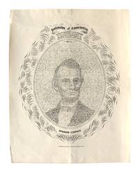
190027986Denver CO: Issued by Halsey M. Rhoads 1900. Very Good. Denver CO: Issued by Halsey M. Rhoads ca. 1900. Later printing. Broadside with calligraphic portrait of Abraham Lincoln in which the script of the Emancipation Proclamation forms the image within a decorative frame surrounded by the names of the members of Congress who voted for the amendment of the U.S. Constitution. 48 x 37 3/4 cm. A few tears to edges with tape mend to verso top edge; folds; minor edge wear; paper residue to verso from previous mount; overall Very Good. <br /> <br /> The original design was by W.H. Pratt in 1865 with just portrait and border and the names to the outside added to later printings. Halsey Rhoads was publisher of the Rocky Mountain Herald and a well known and prominent Denver citizen--even his bout with appendicitis in 1901 treated with leeches and ice garnered several writeups in contemporary newspaper accounts. <br /> This broadside scarce in any printing. <br /> <br /> See Eberstadt 42. Issued by Halsey M. Rhoads unknown
186139392Springfield: Charles H. Lanphier 1861. 4 pp. Folio. 16-1/4" x 23-1/2.". Lightly chipped blank inner edge. Each page printed in six columns each separated by a rule. Very Good.<br /> <br /> The Register no friend of Abraham Lincoln was a Democratic Paper supporting the Crittenden Compromise. Reporting on State and National issues the Register notes "The Crittenden Resolutions have strong friends but the ultra republicans will not take them." Lincoln had insisted that his allies hold firm against Crittenden's Compromise. The Register rebukes Lincoln for his famous declaration that "the Union could not endure permanently part slave and part free." Developments in the fracturing Union are reported. <br /> Lincoln had been elected President nearly three months before the appearance of this issue. His inauguration would occur five weeks later. Paid advertisers include John McClernand and John Stuart who advertise their legal services in the first column of page 1. The large number and variety of advertisements for an array of medical complaints about four columns are surprising- - and a little disturbing. <br /> This issue also reports an incident involving the John Brownites at Boston who were snubbed by British Lord Brougham after inviting him to attend a convention discussing the abolition of slavery. Charles H. Lanphier unknown
1862100336Newspaper folio unbound 8pp. Dampstained browned at edges with some foxing early owner's ink stamp on top margin some small tears and chips along edges and a little creasing. Still in decent shape overall. This is one of the earliest printings of the Emancipation Proclamation which was issued on September 22 1862. The Emancipation Proclamation declared freedom for all slaves in any Confederate state that didn't return to the Union by January 1 1863. Although this executive order did not actually free a large number of slaves it set the stage for the freedom of all slaves. Coverage of the Emancipation in this newspaper begins in the middle of the first page. This newspaper article represents important coverage of a very significant event in American History. archives government exhibits emancipation website
003113Providence: Printed by Brother Bennett Wheeler n.d. 1799. . Hardcover. Very Good. Octavo. 15 ipp. A small piece of the lower margin of pp. 5-6 torn off nowhere near the text. Quarter blue cloth over marbled boards. New endpapers. Original blue-grey wrappers repaired and present. Fred G. Ketcheson bookplate by James Jervis Blomfield a Canadian artist and designer best known for his design of the Vancouver coat-of-arms. A previous owner's name Amos T. Jenckes of Rhode Island on title-page in pencil. ESTC W22111; Evans 35310; Alden J.E. Rhode Island 1614. <br/> <br/> Providence: Printed by Brother Bennett Wheeler, n.d. [1799]. hardcover
16897711<p><b>1689 FOLIO 1ed Abraham Cowley Six Books of Plants Herbs Coca Flowers English </b></p><p><i>"What shall I do to be for ever known</i></p><p><i>And make the Age to come own"</i></p><p><i>I shall like beasts or common people die </i></p><p><i> Unless you write my elegy."</i></p><p>– Abraham Cowley <i>The Motto</i></p><p><i>Abraham Cowley was one of the leading English poets during the 17th-century. This 1689 first edition of the third part of Cowley's works features his famous 'Six Books of Plants'. This set of poems is famous for having the earliest reference to coca in the English language in the poem 'A Legend of Coca'.</i></p><p>Item number: #7711</p><p>Price: $950</p><p>COWLEY Abraham</p><p><b><i>The third part of the works of Mr Abraham Cowley: being his six books of plants never before printed in English viz the first and second of herbs the third and fourth of flowers the fifth and sixth of trees: now made English.</i></b></p><p>London: Printed for Charles Harper at the Flower-de-luce over against S. Dunstan's church in Fleet-street 1689. First edition.</p><p><u>Details</u>: </p><p>· Collation: Complete with all pages</p><p>o 20 166 2</p><p>· References: Lowndes II:539; Perkin B 7; Wing C 6665</p><p>o <b>Perkin notes that Cowley's "fame as a poet exceeded even that of Milton".</b></p><p>· Language: English</p><p>· Binding: Leather; tight & secure</p><p>· Size: ~11.5in X 7.75in 29.5cm x 19.5cm</p><p>Our Guarantee:</p><p>Very Fast. Very Safe. Free Shipping Worldwide.</p><p>Customer satisfaction is our priority! Notify us with 7 days of receiving and we will offer a full refund without reservation!</p><p>7711</p><p>Photos available upon request.</p> For Charles Harper, at the Flower-de-luce over against S. Dunstan's church in Fleet-street hardcover
1701046917Jena: Birchner 1701. Early Edition. Hardcover Vellum. Good Condition. Contemporary vellum soiled frontis and title page stained and detached with some chipping and old tape marks wear to first few pages a few old marks and notes but very good otherwise. Three works bound in one the first two by Hoping typically found together the last with added engraved title published in 1692 in Frankfurt Illustrated throughout endpapers with notes and a few hand sketches. The Ingeber work is a first edition. 155 7; 183 61; 180 4pp<br/><br/>Three early chiromancy volumes bound up together Size: Octavo 8vo. Quantity Available: 1. Shipped Weight: Under 1 kilo. Category: Science & Technology; Magic Paranormal & Occult. Inventory No: 046917. Birchner hardcover
1590M8858Antwerp 1590. Very Good margins are extended. Notes: A fine world map by Abraham Ortelius based on Ptolemy surrounded by the maps of the four continents Americas Europe Asia and Africa. Map is superbly decorated within ornamental 16th century design. Latin text on verso. Size : 310x439 mm 12.20x17.28 Inches Coloring: Original Hand Coloring Reference: Shirley World 176: Van den Broecke 186. Category: Maps World; unknown
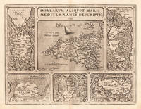
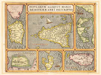
157324542Antwerp: Platin 1573. Other. A very good example printed on excellent German paper. In excellent condition. 365 by 478mm 14 by 18 inches. Original antique copper engraving from the 'Theatrum Orbis Terrarum' by Abraham Ortelius the world's first modern atlas published in Antwerp 1573. Depicting Mediterranean Islands this map is a fine example of 1570s European cartography. Image: 365 by 478mm 14 by 18 inches. An attractive and historically significant 16th-century map for the discerning collector. Abraham Ortelius 15271598 was a Flemish cartographer and geographer born in Antwerp. He is widely regarded as the creator of the first modern atlas the 'Theatrum Orbis Terrarum' Theatre of the World first published in 1570 by Gilles Coppens de Diest in Antwerp. Considered the world's first true atlas it established the modern format of uniform standardized maps bound together in a single volume. Appointed Geographer to King Philip II of Spain in 1575 Ortelius was one of the most influential figures in the history of cartography. His maps are held in the collections of the British Library the Library of Congress and major European institutions. The 'Theatrum' went through more than 30 editions and was translated into multiple languages making Ortelius's maps among the most sought-after in the world of antique cartography.Decorative double page map showing six islands in the Mediterranean Islands Sicily Sardinia Corfu Malta Djerba Elba. Sicily is prominently displayed in the center of the map above the title cartouche.A fine example from Theatrum Orbis Terrarum Antwerp sought after by collectors of antique maps of Italy antique maps of Mediterranean Islands and antique copper engravings for sale. In good condition consistent with age. Light age-toning to the sheet as expected for a 16th-century engraving. Centerfold as published. Broe. 141 Platin unknown
160316331Antwerp 1603. Other. A very good example in vivid handcolor. Minor lightstaining outside the image. 365 by 478mm 14 by 18 inches. Original antique copper engraving from the 'Theatrum Orbis Terrarum' by Abraham Ortelius the world's first modern atlas published in Antwerp 1603. Depicting Mediterranean Islands this map is a fine example of 1600s European cartography. Image: 365 by 478mm 14 by 18 inches. An attractive and historically significant 17th-century map for the discerning collector. Abraham Ortelius 15271598 was a Flemish cartographer and geographer born in Antwerp. He is widely regarded as the creator of the first modern atlas the 'Theatrum Orbis Terrarum' Theatre of the World first published in 1570 by Gilles Coppens de Diest in Antwerp. Considered the world's first true atlas it established the modern format of uniform standardized maps bound together in a single volume. Appointed Geographer to King Philip II of Spain in 1575 Ortelius was one of the most influential figures in the history of cartography. His maps are held in the collections of the British Library the Library of Congress and major European institutions. The 'Theatrum' went through more than 30 editions and was translated into multiple languages making Ortelius's maps among the most sought-after in the world of antique cartography.Decorative doublepage map showing six islands in the Mediterranean Islands Sicily Sardinia Corfu Malta Djerba Elba. Sicily is prominently displayed in the center of the map above the title cartrouche.A fine example from Theatrum Orbis Terrarum Antwerp sought after by collectors of antique maps of Italy antique maps of Mediterranean Islands and antique copper engravings for sale. In excellent condition. Broe. 141 unknown
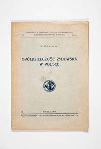
193349709Warsaw: Instytut Badań Spraw Narodowościowych 1933. First edition. Softcover. vg- to vg. Quarto. 45pp. 1. Grey printed wrappers with black lettering on the front cover. Publisher's device on the title page and front wrapper. Published by the Polish National Affairs Research Institute this study is a comprehensive and detailed survey of the state of Jewish economic cooperatives in Poland from the late 19th centuries until the early 1930s. It was part of a larger effort to study Polish-Jewish socio-economics during the period and includes extensive numerical data tables throughout. The work was issued as the first of two in a series of publicartions on behalf of the Committee for the Examination of the Economic Needs of the Jewish Population in Poland Komitet dla Zbadania Potrzeb Gospodarczych Ludnośći Żydowskiej w Polsce. The preface was written by the committees's chair the Polish economist merchant and financier Adolf Peretz 1855-1933. The final section contains annexes appendices and includes an errata sheet tipped in on the final page. Publisher's advertisements printed on the back cover.<br /> <br /> Text throughout in Polish.<br /> <br /> Wrappers light sunned along the edges with minor rubbing and/or creasing to extremities. Light smudge to the front cover. Small closed tear on the title page. Pages throughout sunned with occasional minor creasing to the edges. Wrappers in very good- interior in very good condition overall. Wrappers protected in modern mylar. Instytut Badań Spraw Narodowościowych unknown
171037844Frankfurt a. M. 1710. First edition. Hardcover. fair to g. Folio. 1 leaf 4 leaves 99 leaves 114 leaves 9 leaves 13 leaves 1 leaf. Contemporary brown leather with blind tooling along the border and spine as well as raised bands. Blue edges. Illustrated title page with image of a swan. Head and tail pieces. Commentary on the Talmud that elucidates contradictions within the text. Author makes use of gematriot based on his name. Text printed in double columns with talmudic text in regular script and author's comments in Rashi script. Source notes on side margins. Text in Hebrew. Significant peeling and scratching to leather boards. Bottom edge torn. Tail of spine mostly missing. Some misnumbering to leaves. Leaf 5 was bound after the fact. Name of previous owner on front endpaper. Heavy foxing to leaves. Overall in fair to good condition. hardcover