30 547 résultats
192057336ABHamburg, Fuchs, 1920. Quer-Folio. 30 montierte Farbtafeln, die Trägerkartons jeweils mit gedruckter Legende. Lose in genarbter Orig.-Kartonmappe mit geprägtem Deckeltitel und montierter Farbtafel.
Stato di conservazione: MOLTO BUONO, fioriture ai tagli, qualche fioritura all'interno, alone di umidità al margine inferiore delle pagine, legatura solida e compatta, nessun segno o scritta all'interno. La cronaca del viaggio compiuto dall'esploratore e geografo Luigi Robecchi Bricchetti (1855-1926) in Egitto, attraverso il deserto libico, fino a raggiungere l'oasi di Siwa. Bel volume d'epoca con 164 splendide incisioni nel testo e a tutta pagina, una carta geografica. INDICE I - La partenza II - Lungo la costa III - Dalla valle dell'Elkesir all'altipiano del Maddar IV - La tribù dei Senagrah V - La Libia VI - L'oasi di Gharah VII - L'oasi di Siuwah VIII - Il tempio di Giove Ammone IX - L'idioma di Siuwah X - La gran festa di Siuwah XI - Coltura dell'oasi XII - Il mondo mussulmano XIII - Il ritorno Note Vocabolario dell'idioma parlato nell'Oasi di Siuwah
190910580Leipzig, Brockhaus, 1909. XII, 471 S. Gr.-8°. Farbig illustr. Original Leinwand (Rücken etwas fleckig).
Interessante e decorativa carta geografica del continente africano. La costa del continente è rappresentata in maniera abbastanza esatta, mentre l'interno è quasi interamente inventato. Il Nilo, secondo le conoscenze dell'epoca, si origina dai due laghi Zambre e Zaflan, posti a meridione. Il lago Zambre, inoltre, genera anche i fiumi Congo e Zaire. I mari abbondano di una grande varietà di mostri marini, uno dei quali mostra un volto umano. Pubblicata nell'opera di Heinrich Scherer Atlas Novus exhibens orbem terraguem per naturae opera, historiae navae acveterus monumenta, artistique geographicae leges et praecepta edita in 8 parti, stampate tra il 1702 e il 1710 a Monaco di Baviera. Heinrich Scherer, professore di matematica a Monaco di Baviera, era un gesuita devoto la cui opera sottolineava la gerarchia cattolica e la diffusione delle missioni gesuite in tutto il mondo. Il suo Atlas Novus contiene mappe di tutte le altre parti che mostravano la diffusione del cattolicesimo e delle missioni gesuite. Incisione su rame, in ottimo stato di conservazione. Interesting map of Africa; the continent is presented with a fairly accurate coastline, but most of the interior is entirely fictional. The Nile is shown in the traditional manner with its source in the large southern lakes of Zaflan and Zembre. The Zembre, also labeled Lac Zaire spawns the Congo and Zaire Rivers as well. The seas abound with a variety of fascinating sea monsters, one of which has a human face, and wild animals roam the interior. The title cartouche is surrounded by detailed engravings of the indigenous animals of Africa. Dated 1700, but published in 1710. Decorative map by Heinrich Scherer for his Atlas Novus exhibens orbem terraguem per naturae opera, historiae navae acveterus monumenta, artistique geographicae leges et praecepta...published in eight volumes from 1702-1710 in Munich. Scherer, a devout Jesuit, produced this geographical compendium to depict the Catholic hierarchy and the spread of Jesuit missions throughout the world. Copper engraving, in very good condition. Norwich #62.
1929630733Stuttgart, Strecker u Schröder, 1929-30. M. 2 Portr., 7 Ktn.-Skizzen u. 26 Taf. Unterschiedl. Lwd.-Bde. Bd. 2: St. a. Tit.
185353589ABGotha, Justus Perthes, 1853. Ca. 35 x 24,5 cm. 18 colorierte Karten. 12 Seiten Text. Halblederband der Zeit. [5 Warenabbildungen] Aus der Reihe: Spruner's historisch-geographischer Hand-Atlas, 3. Abtheilung.
Mappa del Marocco, che mostra le grandi città fortificate di Marrakesh, Taroudant e Fez, città, montagne, fiumi, laghi, ecc. Anche Tanger, Cueta e Rio Rabata appaiono.Sono presenti un grande cartiglio decorativo con il titolo e dei velieri. Ortelius è accreditato nel titolo come fonte della mappa.Carta geografica tratta dal “Atlantis sylloge compendiosa or Nova totius Geographia” edito ad Amsterdam all’inizio del XVIII secolo (circa 1705). La lastra utilizzata per questa incisione, come la maggior parte di quelle usate nella produzione di questi due editori, è quella di J. Janssonius, debitamente modificata e ritoccata. Incisione in rame, coloritura coeva, in ottimo stato di conservazione. A striking map of Morocco, showing large fortified towns of Marrakesh, Taroudant and Fez, towns, mountains, rivers, lakes, etc. Tanger, Cueta and Rio Rabata also appear.Large decorative cartouche and sailing ships. Ortelius is credited in the title as the map source.Map taken from "Atlantis sylloge compendious or Nova totius Geographia" published in Amsterdam in the early eighteenth century (around 1705). The plate used for this recording, like most of those used in the production of these two editors, is that of J. Janssonius duly changed and enhanced. Copper engraving, coloring coeval, in excellent condition.
38931Paris Editions Revue Noire 1995 in 8 (19x14) 1 volume broché, couverture illustrée, 416 pages, avec de nombreuses photographies de Pierre Fatumbi Verger. Très bel exemplaire ( Photographies sur demande / We can send pictures of this book on simple request )
188089352Paris: Hetzel 1880. Gebunden. Hetzel unknown
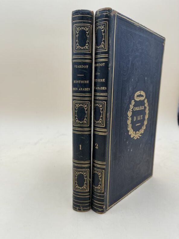
183399916007Paulin éditeur Paris, Paulin éditeur, 1833. 2 volumes In-8 reliés demi-chagrin noir, dos lisses très ornés, plats très décorés estampés à froid, fer doré à couronne de lauriers du Collège d'Aix aux deux premiers plats. 311 + 251 pages. Contient en appendice la liste chronologique des souverains musulmans (Califes d'Orient, Emyrs d' Orient, Califes de Cordoue, Emyrs de Séville, Emyrs d'Afrique (Almorravides, Almohades), Rois de Grenade) et la liste chronologique des souverains chrétiens (Rois des Asturies et de Léon, Rois de Léon et de Castille, Rois de Navarre, Rois d'Aragon, Rois de Portugal, Comtes Souverains de Barcelone). Des rousseurs néanmoins bon exemplaire pour cet ouvrage peu courant.
Paris, Paulin éditeur, 1833. 2 volumes In-8 reliés demi-chagrin noir, dos lisses très ornés, plats très décorés estampés à froid, fer doré à couronne de lauriers du Collège d'Aix aux deux premiers plats. 311 + 251 pages. Contient en appendice la liste chronologique des souverains musulmans (Califes d'Orient, Emyrs d' Orient, Califes de Cordoue, Emyrs de Séville, Emyrs d'Afrique (Almorravides, Almohades), Rois de Grenade) et la liste chronologique des souverains chrétiens (Rois des Asturies et de Léon, Rois de Léon et de Castille, Rois de Navarre, Rois d'Aragon, Rois de Portugal, Comtes Souverains de Barcelone). Des rousseurs néanmoins bon exemplaire pour cet ouvrage peu courant.
189615067Alfred Mame Tours 1896 1 vol. In-folio de 4 ff.n.ch. 288 pp., cartonnage éditeur de l'époque, dos lisse orné, plats à décors, tête dorée.
1805197546Weimar, Landes Industrie-Comptoir, 1805. M. 1 gef. gest. Kte. 2 Bl., XXVIII, 420 S. Hldr. d. Zt. Einbd. beschabt. Beide Deckel beschäd. m. Fehlst. im Bezug u. stark fleckig (Wasserschaden). Kanten bestoßen. Durchg. stark gebräunt, teils stock- bzw. wasserfl. (Bibl. der neuesten Reisbeschreibungen 23).
XIMENES E. Sul campo di Adua. Marzo - giugno 1896. Milano, Treves 1897, In 8°, cart., pp. 316 con molte belle illustrazioni Buono (Good) . <br> <br> <br>
Barcelona, Espasa y Cía., sin fecha (hacia 1896), 32 x 23 cm., encuadernación editorial en holandesa piel, título en lomo y plano superior, retratos del autor y del Rey Leopoldo II de Bélgica + 2 hojas + XXIV + 887 págs. con numerosos grabados intercalados + 7 mapas, 4 de ellos a dos tintas, uno plegado + 4 cromolitografías en colores + 17 láminas y retratos.
Wear to extremities with corners slightly bumped. Top & bottom of spine worn. Previous owner's writing on title-page. Internally VG+ (including maps and illustrations) with binding tight; Sky-blue boards with clay-brown endpapers. Frontispiece and 27 illustrations. 2 maps. ; 8vo; 510 pages
8vo [23 x 16 cm]; 2 volumes, xx, 563, 30 [ads]; x, 682 pp, 2 frontis's including engraved portrait, complete with 13 maps including one with inset, 9 in color 5 of which are folding (2 in pockets), 54 plates, 75 other illus, from drwgs, index. original red pictorial cloth with gilt spine title lettering, partly faded, edge rubbed, corner wear, some minor foxing on few leaves else a clean very good sound set. A picture of this book is available upon request by email. Work 113. A very well-illustrated description and history of east Africa including chapters on slavery, life in the jungle, commercial possibilities, transport, labor, good sections on wildlife, animals, geography, and the peoples in the area, based on the author's extensive travels and expeditions.
folio [40 x 31 cm]; x, 236 pp, 13 fine etched plates including frontis, other plates from drwgs, numerous other illus, the half-title page is present, title page vignette. original half brown leather, gilt title lettering on front cover and spine, gilt spine decoration, lower 2 inches of spine damaged and worn, effecting the inside lower corners of pages, moderate foxing on plates, else clean. A picture of this book is avai The signature of R. T. Coryndon on the front endpaper. Sir Robert Thorne Coryndon was Governor of Uganda and subsequently of Kenya. There was a later edition in 1899. Mendelssohn II, 13: 'The first edition was published in 1895 and soon became very rare. . .Never before or elsewhere, have the winged and furred creatures of the wild lived in their lithe beauty and fantastic grace as in these delicate drawings. . . . the frontispiece, contributed by Sir J. E. Millais, the Last Trek, is perhaps the most beautiful illustration connected with South Africa art.'
8vo [21.5 x 14 cm]; viii, 335 pp, frontis map, folding map, folding tinted plate, other plates and illus, 13 pages of musical notation, songs with separate decorated title page, tables. contemporary red half morocco, gilt spine title lettering, marbled boards, front joint cracking but firm, very slightly foxed on few outer edges but interior clean and fine in very good cover. A picture of this book is available upon request by email. A detailed description of these islands including early voyages to them, Atlantis, The Formigas, The Dollabarets, light-houses, San Miguel, earthquakes, volcanoes, Ponta Delgada, agriculture, climate, emigration, commerce, fish, flora, gardens, people, religion, topography, villages, mineral waters, goats, the baths, ancient pottery, prisons, activities, etc. Royal Geographical Society Catalogue p. 494. No copies were traced at auction in the last 25 years.
1976100179Gantner Verlag, Vaduz 1976. 1029 Seiten - 460 Seiten - 869 S. - 878 Seiten mit zahlreichen Abbildungen, Textfiguren und Karten, Groß 8°, privates Halbleinen mit Rückentitel, Schnitt teils minimal stockfleckig, SS. 617 bis 640 aus Band III/2 fehlen, ansonsten aber gute und innen saubere Exemplare,
- Aden s.d. (ca 1880), Photographie : 24,6x21,4cm / Carton : 29,4x24cm, une photographie encollée sur carton. - Photographie originale en tirage albuminé d'époque encollée sur un carton représentant l'Hôtel de l'Europe et le Grand Hôtel de l'Univers à Aden (Yemen), légende dans la photographie en marge basse. Quelques petits manques angulaires sans gravité. Belle photographie d'Aden telle que Rimbaud la connut. [ENGLISH DESCRIPTION ON DEMAND]
- Imprimerie Impériale, Paris 1809-1829, 71x54cm, une feuille. - Original, unshaved, full-page etching from the "Imperial edition" of the Description de l'Égypte, or 'Recueil des observations et recherches faites en Égypte pendant l'expédition française, publié par les ordres de Sa Majesté l'Empereur Napoléon le Grand [A Collection of the observations and research carried out in Egypt during the French expedition, published on the orders of his Majesty the Emperor Napoleon the Great]'. Produced between February 1802 and 1830 on the orders of Naopleon Bonaparte and published between 1809 and 1828, 1,000 copies were printed and distributed to institutions, on vergé paper with an 'Égypte ancienne et moderne' watermark, visible when held up to the light. Light marginal spotting not touching image, otherwise in very fresh, fine condition. An engraving from the Description de l'Egypte, one of the masterpieces of French printing and the birth of a new field: Egyptology. A gigantic survey of Egypt at the time of Bonaparte's conquests in 1798 and 1799, the work is divided into 13 volumes of engravings making up 892 plates, of which 72 colored, as well as presenting the splendors of the Egypt of the Pharaohs in 9 volumes. The other volumes discuss natural history and present a fascinating portrait of Coptic and Islamic Egypt as it was seen by Bonaparte's Eastern Armies. The 'Egyptian campaign', militarily a disaster, demonstrates, through the engravings of the Description d'Egypte, the scientific success it nonetheless became thanks to the 167 expert members of the Commission of the Sciences and Arts of the Institut d'Egypte [Egyptian Institute] who followed Napoleon's army. The Institut gathered together in Egypt the mathematician Monge, the chemist Berthollet, the naturalist Geoffroy Saint-Hilaire as well as numerous artists, engineers, architects and doctors. They were tasked with re-discovering modern and ancient Egypt and displaying its natural treasures as well as the know-how of its inhabitants. This edition, the so-called "Imperial" edition of the plates for the Description de l'Egypte was printed in four large formats, two of which were specially created for it and christened "Moyen-Egypte" and "Grand-Egypte". A special press was built to print it, the process extending over 20 years, from 1809 to 1829. The "Imperial" edition proved so popular that a second edition, this time in black and white and without the "Egypte ancienne et moderne" watermark - known as the "Royal Edition" - was published during the Restoration by the printing house of C.-L.-F. Panckoucke (Paris). The engravings of the Description d'Egypte owe a great deal to Baron Dominique-Vivant Denon, illustrator, diplomat, collector and later Director of the Musée Napoléon (the Louvre). His exploration of the South of Egypt gave Bonaparte the idea of sending the experts of the Institut there, thus creating a faithful and complete portrait of the area. This was the research gathered together from 1802 in the mammoth Description de L'Egypte. Denon embarked on this story of archeological exploration at the age of 51, reaching first Alexandria and then Cairo before exploring Upper Egypt. Along with the members of the Institut d'Egypte, the Natural History Museum's painter H.J. Redouté (brother of Pierre-Joseph Redouté, author of Roses), the mineralogist Dolomiue, and the draughtsman Joly, Denon then explored the Nile Delta and Lower Egypt. When, however, he joined the 21st Light Infantry Regiment as it marched across Upper Egypt in pursuit of the retreating Mameluks in November 1798, he found himself the only civilian. In the very midst of the battle itself, he reeled off sketches of the works of art that peppered his path right up to the threshold of the Sudan. He said that he had crossed "a country that is, apart from its name, entirely unknown to Europeans, and therefore everything was worth describing" (Voyages dans la Basse et la Haute Egypte pendant le