1 366 résultats
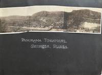
192558598Tchiatouri Georgia & Wallace ID: Georgian Manganese Mining Co. Day Mining Co. ca. 1925-1929. Thick oblong 4to. 11.75 x 8.25 x 2.25 in. 168 pp unpaginated. on thick black paper stock. With 635 silver gelatin photographs sized from 2 x 3 in. up to 8 x 10 in. with the majority sized 3.25 x 5.25 in. nearly all annotated below in neat white ink lettering some w/ annotations somew/in negative indicating negative number those partially lifed from black paper have ink & pencil annotations on versos matching the white ink captions some are RPPC’s w/ captions w/in the negatives at lower fore-edges of image and also present is an 8 page folded manuscript inventory documenting about 400 of the photos closely matching most of the captions. Contemporary flexible black calf Badger post-binder black enamel coated screw-posts a few leaves loose others proud some photos overlapping occasional closed tears a few inner joints neatly repaired at gutter still an outstanding exemplar. This exceptional album provides an essential documentary record of the Soviet era Caucasus of Georgia Azerbaijan Armenia and Abkhazia just a few years after the 11th Red Army invaded Georgia and after a one-week offensive Georgian Bolsheviks took over the country. The album opens with a composite panoramic photo of Tchiatouri notably without the rusting overhead tramways installed by Stalin during the 1950’s. Following the formation of Georgia SSR Tchiatouri and the surrounding regions held some of the largest metallurgical grade manganese in the World and in the 1920’s the Georgian Manganese Company. The subsequent photos depict several of the homes occupied by mine personnel the surrounding region and the main company offices. Many of the photos focus on the local peasants bazaars markets Georgian families fruit markets animal markets and more. Additional photos depict the foreign ex-patriot life in Batum Batumi Adjara with birds-eye views of the city Orthodox churches converted at the time to a Men’s Club as well as tea and banana plantations. Still more photos show Armenian refugees Jewish cigarette boys wine merchants carrying wine in pig skins ox carts horse-drawn street cars village blacksmiths gypsy fortune tellers trained bears and even the local kerosene vendor wagon. Mining operations in Seminoff and Karuto are shown with ore being hauled by ox cart loaded onto rail cars ore crushing mill as well as views of Perevisi Chokruti Shukrut and other ore bearing plateaus their Karuto house. Of additional interest are the photos of the Tchiatouri Monastery a cliffside still functioning convent known as the Mgviemevi Convent featuring a 13th-Century two-nave basilica native village and connecting ore tramways. A series of photos is also devoted to the old Sachakari Modinakhe Castle ruins both inside and out fortifications and local cave dwellings all much more severely damaged decades later in the 1991 earthquake. The compiler has also included photos of the market homes and street scenes in Tiflis as well as the old Roman Walls the local prison Kurdish homes and camel herds along the railway to Moscow scenes along the railroad line between Tiflis & Baku and the Caspian sea port of Russian caviar at Petrovsk. The Harriman Georgian Manganese Co. maintained offices in Moscow and in fact W. Averell Harriman 1891-1986 himself negotiated with Leon Trotsky prior to Lenin’s death and the rise of Stalin forcing him into exile in 1929 for the Manganese mining rights. Many of the photos reveal an extended winter trip through Moscow with a visit to the Kremlin the newly built Lenin’s tomb Red Square the Bolshoi Grand Theater and even a visit to the Polish & Russian Border. After a short trip through France in the midst of rebuilding and Great Britain the couple voyage to Greece Turkey and Palestine. Photos depict Turkish sailboats mosques and street views in Samsun Turkey Constantinople from the Bosphorus the Galata Bridge the Sultan’s palace and Seraglio the Hagia Sophia as well as the old walls. While traveling by rail through Syria and Palestine a series of photos is captioned that the railroad was “made famous by Lawrence in the Revolt of the Desert these pictures taken between Damascus and Tiberius.†The visit through Palestine shows farms Jerusalem the Dome of the Rock Wailing Wall street scenes and the Church of the Nativity. This is followed by tour down the Nile visits to the Pyramids as well as later stops in Somalia Sri Lanka Singapore Saigon Indo-China Hong Kong and Japan. The album is unsigned without ownership markings and has been attributed to Jack Powers and his wife Ruth Fitzgerald Powers 1895-1967 by an unrelated family who held the album. In addition at the rear of the album there are numerous photos of the Day-Hale Co. hunting trips on the Locksaw River in Idaho which included Henry Day Jack Powers E.L. Hale and Dr. Max Smith with Powers clearly identified and closely matching several of the photos depicted in the other parts of the album. Powers began working as a machinist and mechanic with an auto dealership before World War I but by the early 1920’s was actively working as machinery trouble-shooter for Tamarack Custer Mining Co. ad Day Mining Co. subsidiary and also worked as a specialist on compressors. Harriman and his younger brother Roland owned mining operations in Soviet Georgia copper mines in Silesia oil fields in Iran and even a power plant in Poland but after the stock market crash in 1929 they merged with their biggest competitor to become Brown Brothers Harriman & Co. He is perhaps best remembered for development of the Sun Valley Lodge and ski resort in Ketchum Idaho. See: Strishkov & Levine The Manganese Industry of the U.S.S.R. 1986 pp. 7-10; Day Mines Inc. Manuscript Group 306 Records 1921-1985 Univ. of Idaho Special Collections & Archives; Rudy Abramson Spanning the Century: The life of W. Averell Harriman 1891-1986 1992. Georgian Manganese Mining Co., Day Mining Co., unknown
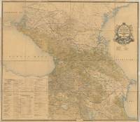
65574Tbilisi: Compiled and Lithographed at the Military Topographical Department of the Caucasus Military District 1870 with corrections to August 1896. Original large-format colour-lithographed map of the Caucasus 132 x 151 cm dissected into 24 panels and backed onto linen text in Cyrillic script folding down to 33.5 x 27 cm. With an extensive key decorative title cartouche and table showing the divisions of the Caucasus. The linen backing is in places dust-soiled and stained some tiny holes in the edges from former wall mounting that have been repaired somewhat browned overall and with a few minor brown spots a few small marginal tears not affecting map repaired with contemporary strips of paper linen edges are slightly frayed in places withal a very good example of this scarce and impressive map. A rare and large-format wall map of the Caucasus region in Russian. The map covers the modern territories of Armenia Georgia Azerbaijan Dagestan Chechnya Kalmykia etc. The map extends south to Tehran and north to Astrakhan. The eastern Black Sea is on the left and the western Caspian Sea is on the right. Beneath the title is a depiction of a railway winding through the mountains and opposite it a galloping horse with a cart crossing the mountains. Later editions were published at least until 1883 and 1903. The later edition is mentioned in 20th-century works dealing with international border disputes in the Caucasus. At the time of its creation it was almost certainly the finest map of the Caucasus produced in the Russian Empire. Tbilisi: Compiled and Lithographed at the Military Topographical Department of the Caucasus Military District, 1870 (with correc unknown
103088Paris Chamerot 1884. . First edition; folio 38.5 x 16 cm; 111p. 55 partly coloured lithographed plates some double page large geological coloured map; contemporary quarter red morocco over marbled boards label and gilt tooling to spine a fine copy. <br /> A rare and interesting work on the spa towns of the Caucasus. The plates show plans for fountains bathing houses and pumping stations of in Piatigorsk Zheleznovodsk Yessentuki and Kislovodsk all of which were popular destinations for 19th century Russians to visit. Aristocracy musicians and artists were drawn to these four towns due to the famous healing powers of the mineral waters.<br /> Paris, Chamerot, 1884. hardcover
Very Good Turkish, Ottoman (1500-1928) Original quarter black leather. Ottoman title-lettered gilt on the spine with decorative elements in compartments. Demy 8vo. (22 x 14 cm). In Ottoman script (Old Turkish with Arabic letters). 459 p., 32 woodcut plates with tissue papers and a folding color map of Khiva calligraphed by Mehmed Vasfi. AH 1292 = Gregorian: 1875. Extremely rare first Turkish edition of this richly illustrated eye-witness travel account of the 1873 Russo-Khivan war and the fall of the Khivan Khanate, by the American war correspondent MacGahan (1844-1878), which was first published in New York in 1874 as "Campaigning on the Oxus and the fall of Khiva", translated by Ahmed Sükrü (?-1876-77) who was the first Postmaster General. After a daring journey through the Kyzil Kum desert, McGahan joined von Kaufmann's army on the banks of the Amu-Darya, shortly before the fall of Khiva. Interesting and lively report with a description of Kazakh- (systematically called "Kirghiz", following the confusing habit of Russian historians) and Yomud Turkmen nomads, as well as of the settled Uzbek, Sart - and enslaved Persians of the Khanate. Probably one of the most complete and objective descriptions of the fall of the Khivan Khanate to three Russian columns which reach it from North and from East, after difficulties due to the climate and the huge distances. The young American makes many friends with Russian officers and gets a lot of information directly from the horse's mouth. There is also a well-documented report about previous Russian attempts to conquer Khiva, which all turned into disasters. The rather civilized behavior of the Russian army with the vanquished Khivans contrasts very much with their cruel and unfair treatment of the brave Yomud nomads, who offer only serious military opposition despite their heavy losses. The Khivan oasis is described as being very fertile and outstandingly well-cultivated. While Mac Gahan is impressed by the beautiful gardens and orchards of the Khanate, he is disappointed by the city of Khiva, the capital, the main residence of its ruler, and the second largest city of the Khanate. Even the Khan's palace (in which he is allowed to spend a few days by the Russian authorities) is disappointing. He visits the treasury room of the palace, in which the fleeing Khan left most of his possessions. He also left his whole harem behind, in his precipitous escape. The text is illustrated with numerous engravings from original designs and paintings by artists (and Russian officers), like Vereschagin and Feodoroff, and enriched with a great number of anecdotes. MacGahan was an American journalist and war correspondent working for the New York Herald and the London Daily News. His articles describing the massacre of Bulgarian civilians by Turkish soldiers and irregular volunteers in 1876 created public outrage in Europe and were a major factor in preventing Britain from supporting Turkey in the Russo-Turkish War of 1877-78, which led to Bulgaria gaining independence from the Ottoman Empire. He learned in 1873 that Russia was planning to invade the khanate of Khiva, in Central Asia. Defying a Russian ban on foreign correspondents, he crossed the Kyzyl-Kum desert on horseback and witnessed the surrender of the city of Khiva to the Russian Army. There he met a Russian Lieutenant Colonel, Mikhail Skobelev, who later became famous as a Russian commander during the Russian-Turkish War of 1877-78. In 1874 he spent ten months in Spain, covering the Third Carlist War. In 1875, he voyaged with British explorer Sir Allan William Young on his steam yacht HMS Pandora on an expedition to try to find the Northwest Passage from the Atlantic to the Pacific. The expedition got as far as Peel Sound in the Canadian Arctic before it met pack ice and was forced to return. OCLC 1014870496.; Özege 7682.; Atabey 744 (Ed. in English).
78911Tbilisi Ekspeditsii turisticheskogo otdela geogr. obshschestva SSR Gruzii 1928. . Landscape 8vo 17 x 24.5 cm 56 pp. illustrated with 25 plates text in Georgian with French and Russian epitome; original printed wrappers small tear to lower cover minor rubbing to edges.<br /> Fine example of the first-hand account of the expedition to the peak of the mount Kazbek undertaken in November 1927 by a group of eleven mountaineers headed by Simon Dzhaparidze 1897-1929. The group started the ascending at the Gergeti glacier bypassed the cone of the peak from the west and reaching its saddle climbed to the top. Subsequently this path was named after Japaridze.<br /><br />Aslanishvili 1891-1957 the author of the account and a participant of the ascending was the Honoured Physician of the Georgian Republic a scientist and mountaineer. <br />The main text is in Georgian accompanied by a summary in Russian and French.<br /> Tbilisi, Ekspeditsii turisticheskogo otdela geogr. obshschestva SSR Gruzii, 1928. unknown
As New English The Turks. [6 volumes set]., publishing consultant: Prof. Dr. Halil Inalcik; editorial board: Prof. Dr.Yusuf Halaçoglu, Prof. Dr. Sükrü Haluk Akalin, Prof. Dr. Süleyman Aliyarli, Prof. Dr. Muhammed Aydogduyev, Prof. Dr. Tuncer Baykara, Prof. Dr. Ali Birinci, Prof. Dr. Tinçtikbek Çorotegin, Prof. Dr. Géza Dávid, Prof. Dr. Feridun Emecen, Prof. Dr. Peter B. Golden, Prof. Dr. Mustafa Isen, Prof. Dr. Norman Itzkowitz, Prof. Dr. Ekmeleddin Ihsanoglu, Prof. Dr. Mustafa Kafali, Prof. Dr. Kemal Karpat, Prof. Dr. Ercüment Kuran, Prof. Dr. Serif Mardin, Prof. Dr. Erdogan Merçil, Prof. Dr. Rhoads Murphey, Prof. Dr. Yuzo Nagata, Prof. Dr. Ahmet Yasar Ocak, Prof. Dr. Ilber Ortayli, Prof. Dr. Victor Ostapchuk, Prof. Dr. Sema Barutçu Özönder, Prof. Dr. Denis Sinor, Prof. Dr. Ahmet Tabakoglu, Prof. Dr. Dmitri Vasiliev, Prof. Dr. Bahaeddin Yediyildiz; Yeni Türkiye yayinlari, Ank., 2002. Original bdg. Hardcover. Color and b/w ills. Mint state. 6000 p. 4to. (28 x 21 cm).
3 voll. in 8, pp. VI + 351 + (1) con 1 tav f.t. rip. inc. all'acq. raff. monete, 1 tav. inc. all'acquatinta raff. due cosacchi a cavallo, 1 cartina f.t piu' volte rip. della Russia; 383 con 1 tav. f.t. all'acquatinta raff. una veduta del Caucaso, 1 cartina f.t. piu' volte rip. della Crimea; 347 + (1b) con 1 tav. f.t. raff. la piana di Odessa, 1 tav. f.t. piu' volte rip. raff. la piantina di Odessa, 1 tav. f.t. all'acquatinta raff. una veduta di Odessa, 1 tav. all'acquatinta raff. la piana del Tagangrog, 1 tav. all'acquatinta f.t. raff. una veduta dei laghi salati, 1 tav. all'acquatinta raff. una veduta di Kekeneis, 1 tav. all'acquatinta raff. una veduta d'Yourzouf. Usuali fioriture alle cc. Legatura in p. p. coeva di colore blu, tasselli ai dd. Edizione originale di questa importante opera del marchese di Castelnau che descrive Russia, Caucaso, Crimea e Odessa. Molte nozioni di carattere geografico-storico-politico arricchite da bell'apparato iconografico.
Good Turkish, Ottoman (1500-1928) Contemporary burgundy cloth bdg. Marginal stains on the front board, foxing on pages, period repairs on some papers' margins. Otherwise a good copy. Stamp of "P. I. Kaia Bibliothek" on title page. With an exceptional provenance, from the collection of "S. Kiiliççioglu", who was a collector of books in Ottoman Turkish related to Asia and China. Roy. 8vo. (24 x 17 cm). In Ottoman script (Old Turkish with Arabic letters). 192 p. The very rare first Turkish edition of the narrative of a Hungarian-Jewish polyglot orientalist and traveler's first-hand account as a spy in the British service in disguise through Central Asia. This work was translated by Abdülhalim (1794-1882) who was the father of the famous Turkish writer Samipasazâde Sezai, fifteen years later he met Vambery first in the Rifat Pasha's Konak [ie. Mansion], while Vambery was teaching linguistics. With his journey paid for by Baron József Eötvös, in 1857 he set off for Istanbul, where there was a network of (quarrelsome) Hungarian émigrés. He survived, first, as a cook's lodger in Pera, then in a cold, damp cellar of the Hungarian Association. To make ends meet he sang Ottoman ballads in the meyhanes, wearing Turkish costumes and calling himself, eventually, Reshid Efendi. Then he climbed, went over to Stamboul, the old city, and was taken up by the Rifat Pasha family, to teach the sons (Raif Bey and his elder brother) Western ways. The journey lasted six months and was very dangerous. There were deserts to cross, with bandits, extreme thirst, and sandstorms. Vámbéry and his companions were holy beggars, dependent on charity for survival, but rumours went about that "hadjis" returning from Mecca had concealed treasure, and it was difficult to find boatmen who would take them across the Caspian without being well paid. All the while Vámbéry kept up his alias as a Turkish dervish, past Russians already suspicious of interlopers; and at the end of the road were emirs, in Bokhara, Samarkand, and Khiva, who put foreigners to death or threw them into a snake pit. However, Vámbéry had the presence of mind and the panache for which Budapest Jews are famous and passed himself off. He encountered the Emir of Khiva, who took an interest in him, and they discussed the possible links between the languages. Sorrowfully they concluded that there was nothing much in it - the music perhaps? The emir produced a court orchestra that made native noises. Vámbéry was asked to sing some of his own native music and produced excerpts from Don Giovanni. He went back via Samarkand and the tomb of Tamerlane to Iran, returned to Budapest, and then got himself to England. British representatives in Tehran had become very interested in his activities. Russian railway-building had gone ahead, and within a few years, the Russians had taken over Central Asia - Samarkand in 1868, and Khiva in 1873. The British were alarmed... (Cornucopia). Vámbéry met Dickens (they regularly lunched at the Athenaeum) and he seems to have inspired Matthew Arnold's most famous poem, Sohrab and Rustum. When he wrote his Travels in Central Asia, the publishers were Byron's and Scott's John Murray, the firm to be published by, though they drove a hard bargain. The Travels sold 24,000 copies. "Vámbéry became an instant celebrity in London and the public's fascination with his adventures and linguistic prowess created a huge demand for his original work upon publication in 1864." "I have divided the book into two parts; the first containing the description of my journey from Teheran to Samarcand and back, the second devoted to notices concerning the geography, statistics, politics, and social relations of Central Asia." (From the preface of Vambery for the original edition). Özege 2391.
Very Good Turkish, Ottoman (1500-1928) Original grey cloth bindings. Occasionally fading on the spines. Overall a very good set. Demy 8vo. (20 x 14 cm). In Ottoman script (Old Turkish with Arabic letters). 8 volumes set: (487, [2] p.; 512 p.; 446, [2] p.; 512 p.; 418, [2] p.; 500 p.; 531, [1] p., 377 p.). Scarce first Turkish edition of this complete set of "Histoire generale des Huns, des Turcs, des Mongols, et des autres Tartaraes occidentaux" (1756-58) by De Guignes who was one of the most prominent orientalists of the 18th century. His most famous and influential work is one on the Turkic peoples of Central Asia, Turkestan, and China. It was translated by Hüseyin Cahit Yalçin (1874-1957), who was a prominent Turkish theorist and his works and translations defending the idea of a homogenous nation became popular within Ittihat ve Terakki [i.e. the Party of Union and Progress]. It was published with the encouragement of Ziya Gökalp (1876-1924), one of the leading theorists of the subject, and edited by Mükrimin Halil Yinanç (1898-1961). Later, it was one of the occidental works which helped form the intellectual foundations of rising modern Turkish nationalism. De Guignes is one of the first orientalists to discuss the etymological and historical geographies of nations such as Tatars, Mongols, and Huns in this work. He originated the proposition that the Huns who attacked the Roman Empire were the same people as the Xiongnu mentioned in Chinese records. This view was popularised by his contemporary Edward Gibbon in the Decline and Fall of the Roman Empire. The idea has been strenuously debated by central Asianists, including Maenchen-Helfen, Henning, Bailey, and Vaissière. Guignes maintained that the Chinese nation had originated in Egyptian colonization, an opinion to which, in spite of every refutation, he obstinately clung. He published a number of articles arguing that Egyptian hieroglyphs and Chinese characters were related, one deriving from the other. Although he was mistaken in that, he is recognized for proving that cartouche rings in Egyptian texts contained royal names, a thesis he developed from a hint previously made by J. J. Barthélemy. Contents: Great Tatarstan, Huns.; Genghis and the Mongols, the Mongol-China emperors, Khalka the Mongols.; China.; Huns and Western Turks.; Iran (Persia).; Konia, Aleppo, Damascus Seljuks, Syrian Atabegs, Kharezm Seljuks.; Tamerlane, The Mamluks of Egypt.; Turks, Iranian Seljuks. Özege 8002.; TBTK 11730.; OCLC 12841603.
Very Good Tatar Original wrappers. Demy 8vo. (21 x 14,5 cm). In Crimean Tatar in Arabic script. 25 p. Chipped on extremities, wear on spine, slightly stained and dusty covers. Overall a good copy. First and only edition of this first regulations consisting of 87 articles under 11 main headings, of the parliamentary (qurultai) of the Crimean People's Republic, which was the first Turkic and Muslim democratic republic in the world, existed from December 1917 to January 1918 in the Crimean Peninsula, a modern day Ukrainian territory currently occupied by the Russian Federation. The Crimean People's Republic was declared by the initiative of the Qurultai of Crimean Tatars, which stipulated the equality of all ethnicities within the peninsula. Noman Çelebicihan (1885-1918) was chosen as the first President of the nascent Republic. The Qurultai, in opposition to the Bolsheviks, published a "Crimean Tatar Basic Law", which convened an All-Crimean Constitutional Assembly, established a Board of Directors as a provisional government, and erected a Council of National Representatives as a provisional parliament. The Board of Directors and the Central Council of Ukraine both mutually recognized each other. This attempt to build a new nation was quickly defeated by the Bolshevik- and anarchist-dominated Black Sea Fleet. Already on 16 December 1917, the Bolsheviks captured Sevastopol where the headquarters of the Black Sea Fleet was located and dissolved the local council of deputies. The power in the city was transferred to the local revkom. The Bolsheviks were supported by some ships of the Black Sea Fleet. To defend itself, the Crimean government created a United Crimean Headquarters on 19 December 1917, that had at its disposal two cavalry and one infantry regiment of Crimean Tatars as well as some Ukrainian and Russian formations that amounted to some thousand people. Several armed incidents took place during January 1918. On 14 January 1918, the Bolsheviks captured Simferopol where they managed to arrest former President of Crimea (Head of Directorate) Noman Çelebicihan who had just resigned on 4 January 1918. He was transferred back to Sevastopol and interned until 23 February 1918, when he was executed without trial. The body of Çelebicihan was thrown into the sea. On the initiative of Çelebicihan on 10 January 1918, the Qurultai created a special commission that conducted talks with the Bolsheviks to stop the armed conflict in Crimea. On the initiative of Çelebicihan on 10 January 1918, the Qurultai created a special commission that conducted talks with the Bolsheviks to stop the armed conflict in Crimea. By the end of January 1918, the Bolsheviks had captured the whole of Crimea and dissolved both the Kurultai as well as the Council of National Representatives. The Red Terror engulfed the peninsula. With Çelebicihan in the Reds' custody, another leader of the Crimean Tatars, Cafer Seydamet Qirimer, managed to escape to the Caucasus across continental Ukraine. Many Crimean military formations retreated to the mountains. The government of Ukraine blockaded Crimea while trying to re-establish control over the Black Sea Fleet and the city of Sevastopol. Any Muslim supporting military formations on the way to Crimea was stopped. That, in turn, triggered a protest from the All-Russian Muslim military council. By the end of January 1918, the Ukrainian government itself was forced to declare war on the Russian SFSR due to the advancement of the Red Guard forces of Moscow and Petrograd into Ukraine without explicit notification. The Bolsheviks briefly established the Taurida Soviet Socialist Republic on Crimean territory in early 1918 before the area was overrun by forces of the Ukrainian People's Republic and the German Empire. Some officials of the national government, such as Seydamet Qirimer who managed to escape the Bolsheviks' terror sought political asylum in Kyiv and petitioned for military help from the advancing Ukrainian Army as w
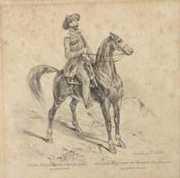
89624Mailand Milan am 8. Juli 1852. . Pencil drawing captioned in Russian and French below 15.5 x 16 cm. 6 1/8 x 6 1/4 in some spotting in contemporary mount.<br /> Fine detailed pencil drawing of a mounted officer from the Caucasus Line Cossack Host. Apparently drawn in Milan it is strongly reminiscent of the military plates published in Vienna by Matthäus Trentsenskiy or the costume drawings of François Hippolyte Lalaisse. The Caucasus Linear Cossack Army was established in 1832 in the Northern Caucasus. Along with the Black Sea Cossack army it defended the Caucasus fortified line from the mouth of the Terek River to the mouth of the Kuban. y 1860 following the end of the Caucasus War it had divided into the Kuban and Terek troops.<br /> Mailand [Milan], am 8. Juli 1852. unknown
xv, [1], 293 pages. Index. Bibliography and Abbreviations. "The first comprehensive history of the Khazars in any Western language... Traces their beginnings, their possible relations with the Persians before Islam, their contacts with the Greeks and wars with the Arabs, their conversion to Judaism, the alleged correspondence with Spain, the relation with the Russions, and, finally, the collapse and disappearance of the Khazar state." - from dust jacket (not included). "Dunlop [1909-1987] taught history at Columbia University in the 1950s and '60s and was a highly-regarded scholar of the Khazars as he had command of the many languages required to study them". - Wikipedia. Usual library markings. Moderate wear. Slight bow to front board. Binding intact. Includes replica dust jacket preserved in archival-grade Brodart. A sound copy of this excellent reference. Book
Very Good Turkish, Ottoman (1500-1928) ÖNT14 In aesthetic modern dark black cloth bdg. with Ottoman lettered gilt and embossing. Roy. 8vo. (24 x 17 cm). In Ottoman script. [4], 138 p., 1 folding huge map. Hegira: 1341 = Gregorian: 1925. First and Only Edition. A rare travel book printed in the Ottoman Empire. Antoine Poidebard, (1878-1955) was a French archaeologist and Jesuit missionary. He pioneered aerial archaeology in the Middle East. In 1925, during his flights in the Syrian desert, Poidebard discovered tiny reliefs thanks to the shadows brought to the ground by the evening shining light, which revealed geometric structures. It was on this basis that he became the first known airborne prospector, as he was able to map all the layout of the Roman limes using the technical means of the air force. Aerial archeology was born. The air explorer Raymond Chevallier identifies two periods of study in the works of Antoine Poidebard: A first, from 1925 to 1932, during which the researches of Antoine Poidebard fixed the course of the Imperial Limes of Basrah at Palmyra and the Tigris; A second, from 1932 to 1942, which made it possible to specify the Roman organization of the rear of the Euphrates and the Orontes. The result of his work is 550 hours of flight divided into 250 missions during which were taken thousands of photographs on a zone of 1,000 kilometers over 300 kilometers. Only one copy in OCLC: 949521769; Koray 1779.; Özege: 9312.
Very Good French Original huge map on cloth. Double elephant folio. (122 x 110 cm). Descriptive texts and titles in French and German. Age toning and slightly foxing. Torn on margins. Repaired. Otherwise a good copy. Borders showed in color. Franz Fried was an Austrian cartographer who lived in Austria and mapped mostly Central and Eastern Europe, and Balkan Peninsula.
iv + 550 + [1] pp. illustré de 30 vignettes dessinées d'après nature (dont 16 planches hors-texte) et d'une carte dépliante dressée au dépot topographique de la guerre à saint Petersbourg, avec dédicace autographe par l'auteur à m.le baron P. Desmaisons, 27cm., reliure cart. (plats marbrés, dos en cuir avec titre doré, usage aucx coins), tranches et feuilles de garde marbrées, bon état, rare
1859X86633Paris, Gide 1859 iv + 550 + [1] pp. illustré de 30 vignettes dessinées d'après nature (dont 16 planches hors-texte) et d'une carte dépliante dressée au dépot topographique de la guerre à saint Petersbourg, avec dédicace autographe par l'auteur à m.le baron P. Desmaisons, 27cm., reliure cart. (plats marbrés, dos en cuir avec titre doré, usage aucx coins), tranches et feuilles de garde marbrées, bon état, rare,
Very Good Turkish, Ottoman (1500-1928) Modern black cloth, Arabic lettered gilt on spine. Roy. 8vo. (23 x 16 cm). In Ottoman script (Old Turkish with Arabic letters). 207 p. First edition of this extremely rare Turkish book, including Qirimi's first-hand account of the Prut War and Treaty (1711) and the defense of the city he participated in during the Russian invasion of Crimea (1735-36). The book was translated into Ottoman Turkish and edited by Turkish turcologist and soldier Necib Asim Yaziksiz, (1861-1935), with annotations, from the original work titled "Umdet al-Akhbar" [i.e. The principle of the news]. Abdulgaffar Qirimi was a Crimean scholar who lived in the Crimean Khanate in the first half of the 18th century and served in various government positions. Qirimi dedicated his work to Genghis Khan, the Golden Horde, and the Crimean Khanate. He reported many original details and, especially for the 18th century, his information is authentic and based on personal descriptions. The main part of the work is devoted to the Golden Horde (starting from Genghis Khan and his descendants), Crimean Khanate, Gerayids, and murzas. When Abdulgaffar Qirimi wrote a history of the descendants of Jochi Khan, he used in his book more than 20 historical works as sources. He stated the names of these works and indicated where he got this or that information. At the same time, he had access to the archives of the Crimean Khanate and used his family legends as well as popular traditions. Plenty of space in his work occupies his own observations as a participant in military campaigns and court life. His work concerning khans Berke, Tokhta, Uzbek, Tokhtamish, and Ulugh Muhammad reflects the popular version and is based on the oral historiography of the Tatars. The Russo-Ottoman War of 1710-1711, also known as the Prut River Campaign, was a brief military conflict between the Tsardom of Russia and the Ottoman Empire. The main battle took place during 18-22 July 1711 in the basin of the Pruth river near Stanile?ti (Stanilesti) after Tsar Peter I invaded Ottoman Moldavia, following the Ottoman Empire's declaration of war on Russia. The ill-prepared 38,000 Russians with 5,000 Moldavians, found themselves surrounded by 200,000 Turks under Grand Vizier Baltaci Mehmet Pasha. After three days of fighting and heavy casualties, the Tsar and his armies were allowed to withdraw after agreeing to abandon the fortress of Azov and its surrounding territory. The Ottoman victory led to the Treaty of the Prut which was confirmed by the Treaty of Adrianople. Özege 21999.; TBTK 479.; OCLC 281773486.
Very Good Turkish, Ottoman (1500-1928) Contemporary cloth bdg. with red boards. Cr. 8vo. (20 x 14 cm). In Ottoman script (Old Turkish with Arabic letters). 35 p. Rare early edition of this first work on the Old Turkic Script (Orkhon-Yenisey runic script) introducing the alphabet to the Turkish and Islamic world written by the founder of the Turkology Institute in Darülfünûn [i.e. Istanbul University], two years after the article, in which the inscriptions were deciphered by the Danish linguist Vilhelm Thomsen (1842-1927) with the contributions of the Russian Turkologist Vasili Radloff (1837-1918), was announced to the scientific world at the Royal Danish Academy of Sciences on December 15, 1893. The book starts with brief information about the first discovery of the inscriptions, their deciphering, the history of the Göktürks who first used the script, the relations of the Göktürks in Central Asia with the Uighurs and the Chinese Empire. The next chapters include a detailed description of the alphabet with its runic characters. Thanks to his contributions to the Turkish language, Necib Asim was awarded a medal and a diploma at the Chicago Exhibition in 1892 and was elected a member of the Société Asiatique in Paris in 1895. The Old Turkic script (also known as variously Göktürk script, Orkhon script, Orkhon-Yenisey script, and Turkic runes) was the alphabet used by the Göktürks and other early Turkic khanates from the 8th to 10th centuries to record the Old Turkic language. The script is named after the Orkhon Valley in Mongolia where early 8th-century inscriptions were discovered in an 1889 expedition by Nikolai Yadrintsev. These Orkhon inscriptions were published by Vasily Radlov and deciphered by the Danish philologist Vilhelm Thomsen in 1893. This writing system was later used within the Uyghur Khaganate. Additionally, a Yenisei variant is known from 9th-century Yenisei Kirghiz inscriptions, and it has likely cousins in the Talas Valley of Turkestan and the Old Hungarian alphabet of the 10th century. Words were usually written from right to left. Contemporary Chinese sources conflict as to whether the Turks had a written language by the 6th century. The Book of Zhou, dating to the 7th century, mentions that the Turks had a written language similar to that of the Sogdians. Two other sources, the Book of Sui and the History of the Northern Dynasties claim that the Turks did not have a written language. According to István Vásáry, Old Turkic script was invented under the rule of the first khagans and was modeled after the Sogdian fashion. Several variants of the script came into being as early as the first half of the 6th century. (Sources: Osmanlica yazilmis ilk Göktürkçe incelemesi: En eski Türk yazisi. Inceleme - çevriyazi by Burcu Uluç, Wikipedia). Özege 4938.; Thirteen libraries have a copy according to the OCLC: 644318223, 1145174424.
014334Editions de l'Art décoratif 0 In-4 Demi-reliure à coins
Generously illustrated with black and white photos and illustrations. Features: Bill Carlisle, Train Robber - An account of the amazing exploits of a man described as "the last of the train-robbers", who would notify officials when he was about to rob a train!; In Quest of the Dragon Lizards - Part I - A thrilling account of adventures on a remote Dutch East Indies island in pursuit of prehistoric flesh-eating lizards (the Komodo dragon) - with photos; The City of Golden Geese - A lively photo-illustrated account of the foie gras industry in the old city of Strasburg in Alsace; Mungoro Meets His Match - A Rhodesian tale; The End of the Chase - A hunt for a monstrous elephant near Lake Nyasa; Photo of a Kentish stilt-walker in field of hops; The Man in No. 35 - How a British officer discovered, in a Russian prison, Julius Weinberg, a Jewish banker who had actually handed Lenin and his accomplices ten million marks from the German Government in order to finance the Bolshevik revolution that destroyed Russia as a fighting force - the little man knew too much, and paid with his life for his refusal to surrender the incriminating receipts; Cycling Round the World - Part II - Kai Thorenfeldt spent over two years riding over 20,00 miles! - with photos; The bachelor Homesteaders of British Columbia - A breezy photo-illustrated account of the adventures and hardships of this cheery, happy-go-lucky class of men; The Girl Stowaway of the Cecilie - Part II - Jeanne Day snuck aboard the Herzogin Cecilie before it departed Australia for Falmouth - with photos; A Ride in the Night - An officer of the King's African Rifles falls ill on the Abyssinian frontier of Kenya Colony; The Chief's Gift - A tale from a New Zealand sheep farmer; Teddy Murphy's Close Call - A child disappears into a well in Moose Jaw, Saskatchewan. 84 pages plus 12 pages of nice vintage ads. Unmarked with average wear. A sound copy of this nice vintage issue. Book
1860X119853Moskva [Moscow], I Tparani Lazarean chemarni arewelean lezuats 1860 286pp., 24cm., text in Classical Armenian, bound in a solid modern hardcover in black cloth, original frontcover preserved, [Movses Dasxuranc'i is a 10th century historian concerned with the Aluank. This is the first publication (Editio princeps) of his "History of the Caucasioan Albanians" published by Emin in Moscow (1860)], cfr. OCLC 807841820, X119853
185954671P., Gide 1859 In-4 18,5 x 27 cm. Reliure demi-toile moderne, IV + 550 pp., 16 planches hors texte, 30 vignettes dans le texte 1 carte dépliante in fine.
1879247Paris, Gauthier-Villars, 1879 ; in-8 de [7] ff., 284 pp., [1] f., reliure de l'époque chagrin aubergine, quatre filets dorés en encadrement sur les plats, dos à nerfs orné, tranches dorées, roulette intérieure.
185515126Paris, Garnier-Frères, 1855 ; grand in-8 ; demi-veau glacé rouge sang, dos à faux-nerfs plats noirs à froid, caissons décorés et dorés aux petits fers dans un encadrement de filet doré, titre doré, plats de papier gauffré rouge (reliure de l'époque) ; VII, 528 pp., 18 planches hors-texte finement gravées sur acier d'après Allom, Beutley, Salmon et Leitch, très grande carte dépliante par L. Berthe, lithographiée et coloriée à la main.
New English Genel Türk tarihi. 10 volumes set., edit by: Ali Birinci, Hasan Celal Güzel, Yeni Türkiye yayinlari, Ank., 2002. Original bdg. Hardcover. New. 10 volumes set. 4to. (26 x 16 x 50 cm). 209 articles in total 8000 p. Color ills. =[General Turkish history].