BRITISH TRAVEL and HOLIDAYS ASSOCIATION.Livre Rare Book
34 279 résultats
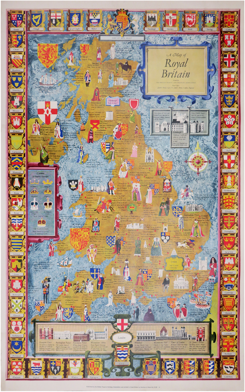
1960LBW-8445Londres, British Travel and Holidays Association, [circa 1960]. 983 x 608 mm.
Grande ed interessante carta del Mediterraneo pubblicata da William Faden nel "General Atlas".Si tratta di un insieme di due mappe: il foglio occidentale comprende il territorio del Portogallo, della Spagna, Italia, Maghreb e parti della Francia e dei Balcani; sono incluse le isole spagnole di Minorca, Maiorca e Ibiza insieme a Corsica, Sardegna Malta e Sicilia. Il foglio orientale comprende la parte orientale che si estende dalla Croazia ad est fino all’Iran e dalla Crimea a sud fino al delta del Nilo in Egitto; sono comprese le isole di Creta, Cipro e il Mar Nero. La Grecia e la Turchia moderne compaiono nella loro interezza (compresa l’area precedentemente nota come Kurdistan), nonché Georgia, Armenia, Giordania, Israele, Palestina, Iran, Iraq, Siria, Ucraina e Balcani. Codificata per colore in base al territorio politico, l’opera raffigurata la penisola italiana divisa in vari stati e ducati.Acquaforte, su carta vergata coeva, finemente colorata a mano in epoca, in perfetto stato di conservazione. A large map of the Mediterranean Sea by Faden's General Atlas.This is an appealing 1785 map of the Mediterranean region issued by William Faden. A set of two maps, the western sheet covers from Portugal, Spain, Italy, the Maghreb or the Barbary Coast of Africa and includes parts of France and the Balkans. The Spanish Islands of Minorca, Majorca and Ibiza are included, along with Corsica, Sardinia, Malta and Sicily. The eastern sheet extends from Croatia east as far as Iran and from Crimea south to Egypt’s Nile Delta, including the islands of Crete or Candia and Cyprus and the Black Sea. Covers the modern day Greece and Turkey in their entirety (including the area formerly known as Kurdistan), as well as Georgia, Armenia, Jordan, Israel, Palestine, Iran, Iraq, Syria, Ukraine and the Balkan nations. Color coded according to political territory, the map notes several important towns, rivers, cities, lakes, islands and mountains along with other topographic features. Depicts the Italian peninsula divided up in to various states and duchies. Jerusalem, Baghdad (Bagdad), Constantinople (the capital of the Roman Empire) and other important cities.When this map was drawn this region was dominated by the waning Ottoman hegemony. The Ottomans would nevertheless continue to exert a powerful influence on this region until the early 19th century. The Barbary Coast was a hotbed of piracy – much like the Somali Coast today. The Barbary Pirates would attack trading ships passing through narrow Gibraltar straits and western Mediterranean. Ships would be destroyed or appropriated, cargo seized and the crew and passengers enslaved. By the early 19th century, piracy in this region had become so intense that the United States launched its first major naval offensive against Tripoli. The resultant 1805 Battle of Derne later inspired a portion of the lyrics of the Mariners’ Hymn ‘To the shored of Tripoli’.This map was printed and issued by William Faden in his 1811 edition of the General Atlas. Phillips (atlases) 6010, 6013, 6047.
Carta geografica del Mediterraneo con due cartigli contenenti la carta dell'Italia e della Grecia. Incisione in rame, coloritura coeva dei contorni, in ottimo stato di conservazione. Rarissima. Chart of the mediterranean sea with two carouches containing Italy and Greece. Copperplate, contemporary outline colour, in excellent condition. Very rare. Zacharakis C. G. "A Catalogue of Printed Maps of Greece 1477 - 1800" (2009), n. 738
Hardcover with unclipped dust jacket. Minor edgewear to jacket, including taped repair to front cover at upper hinge and light foxing to jacket inside. Slight bump to rear board lower corner. No other faults, clean throughout. AD Used
"Printed on paper chosen to look and feel like medieval vellum, this selection of medieval texts and images taken from books of hours, poems, chronicles, wills, sagas, letters and many other sources to create a gloriously illuminated mosaic of life in the Middle Ages." Introducton by Emmanuel Le Roy Ladurie. Typeset in Poliphilus and Giovanni Book fonts, printed in5 colours on Gardapat 130gsm, and printed in Italy by Grafiche Milani. 208p, list of text sources and an index of manuscripts. A very handsome gift volume Book
201028578Toronto: Self Published 2010 Book. Fine. Soft cover. Signed by Authors. First Thus. Personal biography of a young girl from Zuzemberk in Slovenia whose family left because of the disruptions in Yugoslavia after World War II. Descriptions of places and people and travels her marriages to Franc Petric and Ivan Ancimer her children and grandchildren. Illustrated not just with family photographs but also with copies of the various documents issued at that time to displaced persons and refugees on their way to temporary camps and then on to Canada. 87p illus Signed on title page. NO copies found in WorldCat or National Library of Canada. Self Published paperback
158118[Paris], Imprimerie de Madame veuve Porthmann, s.d. (1821) in-4, 16 pp., dérelié.
124344Kossuth Könyvkiadó Livre en français, hongrois, anglais, allemand. In-4 relié 27 cm sur 31. 158 pages. Nombreuses photographies en noir et blanc. Bon état d’occasion.
1929002150London: George Allen & Unwin 1929. Very Good -. Lucas Samuel. First published in The History of Hitchin vol. 2 1929; this separate edition published later the same year. 150 2 p.: 9 in-text drawings 13 leaves of illustrations many by Samuel Lucas; 25 cm. Green cloth with gilt-stamped spine title and decoration; gilt-stamped center medallion on both boards. Title page in red and black with decorative border. Publisher's device on page following index. Top page edges gilt. Includes bibliography and index. Faint white library call numbers on spine. Front fixed endpaper bears inscription: Friends House Preparative Meeting Library. The same with Friends House Euston Road London stamped on the front free endpaper. Former owner's inscription on front free endpaper: "Helen F. Carpenter Withleigh West Heath Rd Hampstead London NW3." A history of the Society of Friends in Hitchen Herfordshire England. In Very Good- Condition: spine is sunned slightly faded; ends of spine and corners rubbed with fraying at head of spine; remains of white call numbers on spine; cover slightly soiled; foxing primarily on first few leaves including title page; otherwise clean and tight. George Allen & Unwin unknown
18493628Philadelphia: Thomas Cowperthwait & Co 1849. First edition. Hardcover. Fair. xv 544 pgs. 5 x 8 in. Quarter brown calf with brown cloth boards. Condition of the book is FAIR; spine missing. Corners bumped and worn. Cover and text have water stains front pastedown and ffep darkened by water damage text moderately foxed throughout. Cover scuffed. Binding is sound. Upper edge of text block darkened all foxed. Thomas, Cowperthwait & Co hardcover
1832204819London: Harvey and Darton 1832. "And now some of our readers may be aware that one day in London to those who visit it for the first time presents more novelties and objects of interest than could possibly be described in a little book like the present." 1832 fictionalised guidebook "attending . chiefly to things which form the features of new London": viz.: the Thames Tunnel 19th-century exhibitits at the British Museum gas-lights. Green leather boards with red leather on spine; showing light wear bumped at corners small chip at top edge of spine. Endpapers a little foxed; ink stamp on BEP. Illustrated title page frontispiece and four plates also a little foxed; contents otherwise clean and sound. First Edition. Hardcover. Good/No Dust Jacket. Used. Harvey and Darton Hardcover
Hardcover with jacket in very good condition. Jacket is lightly worn, sunned and creased on edges. Minor marks on front board and page block. Hardcover front upper leading corner and spine ends are bumped. Pages are clean and text is clear throughout. HCW Used
1908060725New York: Charles Scribner's Sons 1908. Book. Very Good. Hardcover. 1st Edition. 8vo - over 7¾" - 9¾" tall. Green cloth lettered/decorated in gilt bordered in blind deckled text block edges with top edge in gilt. Cloth is modestly flecked on portions of both covers with slightly rubbed extremities. Firm binding clean interior beyond a few slight spots of foxing and Christmas 1908 gift inscription inked on upper front flyleaf. ix201 pp. illus. w/ sepia plates. 1st ptg.: Oct. 1908. Charles Scribner's Sons Hardcover
190919271New York: Charles Scribner's Sons. 1909. Hardcover. Near Fine. An unusually handsome copy - the best we have seen so far. Nice gift inscription with ink on first blank page ; Green decorative boards with gilt lettering. "The motor-car has restored the romance of travel " writes Wharton who in this lesser known book tools around in Gaelic history from Rouen to Nimes to Soissons. Apparent 2nd Edition with publishing year 1909 on title page - unlike the first edition the top edge is not gilt ; B&W Photographs; 8vo 8" - 9" tall; 201 pages . Charles Scribner's Sons hardcover
DEMO016748INew York: Scribners 1964. First edition. Hardcover. Very Good /very good. Photogravures. 8vo 211 pages brown clothbacked boards; edgeworn dj. <br/><br/>'If you are lucky enough to have lived in Paris as a young man .it stays with you for Paris is a moveable feast.' Hanneman A31a. Sketches of the author's life in Paris in the Twenties. "All things truly wicked start from an innocence. . There is never any ending to Paris and the memory of each person who has lived in it differs from that of any other - p.210-11." Plates. Scribners hardcover
1955SB14766London: Novello and Company Ltd. 1955. Endpaper maps; Textblock is clean and tight; Lightly character-soiled top edge; Boards are slightly bent; Blue cloth divet along top edge. Sunned and bumped head and foot of spine; Lightly character-soiled binding; Unclipped but very edge-worn dust jacket chipped at corners and spine tips; Moisture soiled top edge chipped worn and torn edges. 362p. including index. First Edition. Cloth. Very Good/Good in mylar. Illus. by Plates/Mapped End Papers. 8vo - over 7¾" - 9¾" tall. Hardcover. Novello and Company Ltd. Hardcover
192850324101050Richard Jackson Limitted Leeds 1928. First Edition. Hardcover. Very Good Condition/No Dust Jacket. This Edition is Limited to 500 Copies Each Numbered. The Number of This Copy is 65. Limited Edition. Contains black and white frontis full page illustration facing title-page and black and white plates full page illustrations. No dust-jacket. Undated by publisher. Dated by reference to British Library catalogue. Quantity Available: 1. Shipped Weight: 1-2kg. Pictures of this item not already displayed here available upon request. Inventory No: 50324101050. All our books music and maps are sent by a tracked mail service. This book is heavier than 1kg and may incur additional delivery charges on some delivery services to some locations. Richard Jackson Limitted hardcover
197515189Europa könyvkiado 1975 315 pages IN4. 1975. Reliure Editeur avec jaquette. 2 volume(s). 315 pages. A könyv a második világháború képes történetét mutatja be fotómonográfia sorozat részeként az Európa Könyvkiadó gondozásában. A tartalom alapján a kötet a háború eseményeit vizuális dokumentumokkal illusztrálja
235008London, Johnson, 1809 in-4, XII-324 pp., portr., 1 gde carte dépl., 1 litho. h. t. et 1 plan dépl., demi-basane fauve à coins, dos lisse, filets dorés (reliure de l'époque). Manque aux coiffes, début de fente aux mors, coins usés.
12mo [17 x 11 cm]; iv, 132, [viii, ads] pp, lithographed frontis of owl swooping over her nest by J. Wolf, tissue guard, engraved title page vignette. original green pictorial cloth with gilt picture of bird on cover, gilt spine title lettering in decorative border, rear cover slightly rubbed, near fine clean copy, gilt bright. A picture of this book is available upon request by email. Ripley 69. Wood 305 described as wanting. A narrative of the author's travels in the Orkney Islands north of Scotland in the summer of 1860, with much on nature, bird life, people he met, topography.
589p. , illus. Hardcover good conditon in full calf spine worn & chipped
Carta geografica nautica dell'Oceano Atlantico. Incisione inserita nell'opera "A New, Royal, Authentic and Complete System of Universal Geography, Ancient and Modern: Including All the Late Important Discoveries Made by the English, and Other Celebrated Navigators .. History and Description of the Whole World... Likewise the Essence of the Voyages of the Most Enterprising Navigators..." edita a Londra da J. Cooke nel gennaio del 1787
Carta geografica dell'Europa, inserita nell'opera "A New, Royal, Authentic and Complete System of Universal Geography, Ancient and Modern: Including All the Late Important Discoveries Made by the English, and Other Celebrated Navigators .. History and Description of the Whole World... Likewise the Essence of the Voyages of the Most Enterprising Navigators..." edita a Londra da J. Cooke nel gennaio del 1787. Pieghe editoriali
A New Chart of the Mediterranean Sea Composed from the Draughts of the Pilots of Marseilles Corrected by Astronomical Observations: By Order M. GR Le Comte de Maurepas. To which are annexed by the Editor A Draught of the Streight Mouth including the Bays of Cadism Gibraltar and Malaga: also Ports of Leghorne, Naples, Mahon, Smyrna, Salonichi, Scandaroon and Alexandria: with the Course of the Nile from the last place to Cairo.Acquaforte, stampata su tre fogli di carta vergata e applicate su un supporto di carta blu, dimensioni totali 580x1280 mm. Firmata con imprint editoriale in alto a sinistra, sotto al titolo: Sold by William Mount & Tho.s Page Tower Hill. London.Grande carta del Mediterraneo - su tre fogli - basata sulla carta del Dépôt des cartes et plans de la Marine, stampata a Parigi nel 1737 ed incisa da Guillaume Dheulland, o, più probabilmente, sulla replica inglese pubblicata da John Senex nel 1738. Se l’originale francese, infatti, è la fonte delle informazioni nautiche, la versione di Senex è il modello per i piani nautici dei diversi porti del Mediterraneo, perfettamente replicati in questa tavola. La carta è firmata da William Mount e Thomas II Page, rispettivamente figlio di Richard e Thomas I, primi esponenti della tipografia che stampò il The English Pilot fino all’inizio del XIX secolo.La carta appartiene alle cosiddette “blueback charts” che iniziarono ad apparire a Londra nella seconda metà del XVIII secolo; erano carte nautiche di grande o grandissimo formato, così denominate per il loro particolare supporto in carta blu. Il supporto - un foglio blu comunemente disponibile e usato tradizionalmente dagli editori per contenere opuscoli a stampa non rilegati - fu adottato come un modo pratico per rafforzare la carta di bassa qualità utilizzata dagli editori di carte nautiche nel tentativo di ridurre i costi. Le prime carte blueback conosciute sono quella pubblicate dalla tipografia Mount & Page intorno al 1750 e successivamente da Robert Sayer (1787). La tradizione decollò all’inizio del XIX secolo, quando gli editori britannici come John Hamilton Moore, Robert Blachford, James Imray, William Heather, John William Norie, Charles Wilson, David Steel, RH Laurie e John Hobbs iniziarono a dominare il commercio della cartografia nautica. Le bluebacks diventarono così popolari da essere adottate dagli americani Edmund March Blunt e George Eldridge, così come da cartografi scandinavi, francesi, tedeschi, russi e spagnoli. Le carte blueback rimasero popolari fino alla fine dell’800, quando organizzazioni sovvenzionate dal governo, come la British Admiralty Hydrographic Office e la United States Coast Survey, iniziarono a pubblicare le proprie tavole nautiche su carta di alta qualità che non richiedeva rinforzi.Bibliografia: cfr. S. Fisher, The Blueback Charts, in “The Map Collector” n. 31, Londra 1985, pp. 18-23; S. Fisher, The Makers of the Blueback Charts, History of Imray Laurie Norie & Wilson Ltd, Londra 2001; cfr. National Maritime Museum, Catalogue of the Library - Vol. Three, Atlas & Cartography, Londra, 1971, pp. 460-462; cfr. R. Shirley, Maps in the Atlases of the British Library, Londra, 2004, pp. 1236-1266; cfr. The Compleat Plattmaker: essays on Chart, Map and Globe Making in England in the Seventeenth and Eighteenth Centuries, Berkeley, 1978. A New Chart of the Mediterranean Sea Composed from the Draughts of the Pilots of Marseilles Corrected by Astronomical Observations: By Order M. GR Le Comte de Maurepas. To which are annexed by the Editor A Draught of the Streight Mouth including the Bays of Cadism Gibraltar and Malaga: also Ports of Leghorne, Naples, Mahon, Smyrna, Salonichi, Scandaroon and Alexandria: with the Course of the Nile from the last place to Cairo.Etching, printed on three sheets of laid paper and applied on a blue paper support, total dimensions 580x1280 mm. Signed with editorial imprint at the top left, under the title: Sold by William Mount & Tho.s Page Tower Hill. London.Large map of the Mediterranean - on three sheets - based on the work of the Dépôt des cartes et plans de la Marine, printed in Paris in 1737 and engraved by Guillaume Dheulland, or, more probably, on the English copy published by John Senex in 1738. If l the French original, in fact, is the source of the nautical information, the version of Senex is the model for the nautical plans of the different harbours of the Mediterranean, perfectly replicated in this work.The map is signed by William Mount and Thomas II Page, respectively son of Richard and Thomas I, first exponents of the typography who printed "The English Pilot" until the beginning of the nineteenth century.The map belongs to the so-called "blueback charts" which began to appear in London in the second half of the 18th century; they were nautical charts of great or very large format, so named for their particular blue paper support. The media - a blue sheet commonly available and traditionally used by publishers to contain unblocked printed pamphlets - was adopted as a practical way to reinforce the low quality paper used by nautical charts publishers in an effort to reduce costs. The first known blueback cards are the ones published by Mount & Page typography around 1750 and later by Robert Sayer (1787).Tradition took off in the early 19th century, when British publishers such as John Hamilton Moore, Robert Blachford, James Imray, William Heather, John William Norie, Charles Wilson, David Steel, RH Laurie and John Hobbs began to dominate the cartography trade boating. The bluebacks became so popular as to be adopted by the Americans Edmund March Blunt and George Eldridge, as well as by Scandinavian, French, German, Russian and Spanish cartographers. The blueback cards remained popular until the end of the 1800s, when government-subsidized organizations, such as the British Admiralty Hydrographic Office and the United States Coast Survey, began to publish their own nautical tables on high-quality paper that did not require reinforcements.Bibliografia: cfr. S. Fisher, The Blueback Charts, in “The Map Collector” n. 31, Londra 1985, pp. 18-23; S. Fisher, The Makers of the Blueback Charts, History of Imray Laurie Norie & Wilson Ltd, Londra 2001; cfr. National Maritime Museum, Catalogue of the Library - Vol. Three, Atlas & Cartography, Londra, 1971, pp. 460-462; cfr. R. Shirley, Maps in the Atlases of the British Library, Londra, 2004, pp. 1236-1266; cfr. The Compleat Plattmaker: essays on Chart, Map and Globe Making in England in the Seventeenth and Eighteenth Centuries, Berkeley, 1978. S. Bifolco, "Mare Nostrum, Cartografia nautica a stampa del Mar Mediterraneo" (2020), pp. 226-227, tav. 105.
0282069089.Gpaperback. Good. Access codes and supplements are not guaranteed with used items. May be an ex-library book. paperback