CHASTELLUX (François-Jean, Marquis de)Livre Rare Book

28 513 résultats
226050A Paris, chez Prault, imprimeur du Roi, 1786 2 vol. in-8, 390 pp. et 362 pp., (1) p. d'errata, 2 cartes et 3 planches repliées, veau blond, dos lisse, filets dorés, filet à froid en encadrement sur les plats, tranches citron (rel. de l'époque).
179517633Paris, Maradan an-IIIe - 1795 ; in-8, broché ; (4), 292 pp. , carte dépliante «Des Etats mitoyens de l'Amérique unie dressée d'après les Autorités les plus nouvelles et les mieux choisies par Thomas Cooper (gravé par P.F. Tardieu)».
192247Hambourg, Pierre-François Fauche, 1795 in-8, XX-218-74 pp., avec un frontispice gravé par Landy et une carte dépliante, demi-basane blonde à coins, dos lisse orné de filets dorés, pièce de titre cerise (reliure de l'époque). Coins un peu abîmés, mais bon exemplaire.
158947Paris, Imprimerie Nationale, 1885-1892 5 forts vol. in-4, [4]-X-707, [4]-86, [4]-X-868, [4]-XII-721 et [4]-VI-721 pp., avec 12 planches, dont 5 frontispices et une carte dépliante du théâtre des opérations, index, broché. Dos abîmé avec premier plat de couv. détaché aux tomes 4 et 5.
1979af82Larry B. Wright Sélection Abraxas-libris Sérigraphie 1979 Magnifique sérigraphie imprimée par les ateliers pour le compte de Darryl Hughto 30 x 30 pouces (inches), (76.2 x 76.2 cm). Tirage, signé et numéroté au crayon de bois à 160 exemplaire, ici le numéro 9. Tampon sec à étoile de l'éditeur Larry B. Wright à New-York, on trouve dans le même coin le tampon sec avec la date 1979 et le nom : Norman Orleans (probablement l'imprimeur). Daryk Leo Hughto est né en 1943, il expose pour la première fois à la Tibor deNagy Gallery en 1971, puis au musée Gugenheim en 1977. Et ensuite dans différents musée : Centre Georges Pompidou, Metropolitan Museum of Art, New York, NY, Corcoran Museum of Art, Washington, DC, MFA Boston, MA, Comino Foundation, Valduz, Lichtenstein, MFA Houston,TX, Edmonton Art Gallery, Alberta, Portland Museum of Art, Oregon, and dans d'autres nombreux musée en Amérique du Nord et en Europe. ; quelques petites marques, sur les marges, bon état. Livraison a domicile (La Poste) ou en Mondial Relay sur simple demande.
190886S.l., 1792-1821 11 vol. in-8, basane porphyre dos lisse orné, roulette dorée en encadrement sur les plats, tranches mouchetées (reliure vers 1820). Petites usures au dos, qqs épid. sur les plats, qs mouillures sans gravité. Bon ensemble.
1846005928New York: Paine & Burgess 1846. Two Volumes bound in One viii 340 pages and vi 136 pages respectively First Edition distinguished by the collation of Volume I original blind-stamped cloth with decorative gilt titling to spine all edges gilt wear and exposure to spine head and tail tips lightly bumped and exposed Has a total of 15 plates which includes a frontispiece portrait of the author in Volume 1 and one colored frontispiece portrait of Pocahontas in Volume 2 a facsimile of a letter from Dolley Madison to the author and 12 engraved illustrations by F.O.C. Darley occasional scattered foxing. Spine loose. Inscribed by the Author. Cloth. Very Good/No Jacket Issued. 4to - over 9¾" - 12" tall. Paine & Burgess hardcover
1940007791New York: Charles Scribner's Sons 1940. 471pp. First edition later printing. Hemingway's great novel of the Spanish Civil War focuses on a small band of brave Spanish women and men risking their lives to carry out the explosion of a bridge. American Robert Jordan is there to join their dangerous mission and in doing so falls in love with a beautiful Spanish girl Maria. DJ chipped. Text clean. . First Edition. Cloth. Near Fine/Very Good. 8vo - over 7¾" - 9¾" tall. Charles Scribner's Sons Hardcover
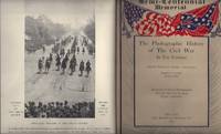
1911biblio135<p><strong>New York: Review of Review Corp. Very Good. 1911. First Edition. Hardcover. </strong>All 10 volumes of the Semi-Centennial Memorial Photographic History of the Civil War. Published in 1911 on the 50th anniversary of the beginning of the war. Condition of each volume is Fine. Covers have slight wear very light rubbing and some spotting. Top page edges on all 10 volumes gilt which is in very nice shape. Gilt lettering and decorations on all 10 spines also bright and intact. Inside pages including hundreds of photographs are clean and bright with no spotting or foxing. All 10 volumes bound in blue boards no DJ. Each volume is slightly oversize and contains about 300 pages of photographs and text for a total of about 3000 pages of photographs and explanatory text for the set. A heavy set that will require extra postage. Please contact us for postage prices. ; 8vo 8" - 9" tall . endpapers are blue with gold top edges. This is the first edition of this epic work and has thousands of scenes photographed from 1861-1865. It has has special text from about 39 knowledgeable people Pres. Wm. Taft and officers of both the Confederate and Union Armies. Some of the photos were previously unpublished were from private individuals. The last volume number ten has the "2-Ed" in the bottom margin of page 323 which makes this volume ten a first edition but second issue of volume ten. A very fine set. Call us for shipping quote as each book weighs 4 pounds.</p> The Review of Reviews hardcover
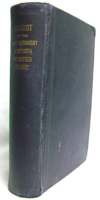
1916IB249Stillwater MN: Easton & Masterman 1916. Gilt titling to spine. Previous owner's penciled gift inscription on ffep a few words underlined in ink on p.441. lightly creased corners of front free end papers through p.5 and p. 395-418 large chip on upper corner of p.7/8 p.7-10 loose at hinge yet still attached. Very light age staining to endpapers. Otherwise textblock very clean and tight. Light character soiling to front cover of binding bumped corners light fraying to corners edges and spine. Front and rear hinge appear to have been reattached and repaired. Binding is tight. 508pp. including Appendices and Index. First Edition. Blue Cloth. Very Good. Illus. by Plates/Maps/Illustrations. 8vo - Over 7 3/4" -9 3/4 " Tall. Hardcover. Easton & Masterman Hardcover
1870biblio1230<p>This is a good complete copy of the proceedings of the NC State House Of Representatives of the 1869-70 General Assembly. A very interesting record of legislation in the early Reconstruction Period this is an original copy of the record containing all of the legislation officially enacted or not enacted. A North Carolina historian's delight this book was obtained many years ago through the Stevens Book Co. of Raleigh. An extreme rarity on the public market.</p><p>Photos on request.</p> W.A. Smith & Company Printers hardcover
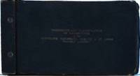
1929010615Cleveland Cincinnati Chicago & St. Louis Railway Big Four 1929. Book. Very Good. Limp Cloth. Oblong 8vo. "Book No. 82" at title page. A book clearly used by a railroad office. Oblong black cloth printed in gilt 4 3/4" h x 9" w. Approx. 144 pp. in blueprint cyanotype printed rectos only. Bound with two metal screws with label for Buchan Patent Lock Washers inside of rear cover. Very Good lacking a 2" patch of cloth rear cover at spine edge wear and light soiling. Published 1929 Mar. 1 "This book correct to date as shown below" with additional dates in ink of 1930 Apr. 1 and 1930 July 1. Several pages with ink corrections deletions and additions. Manuscript in pencil verso of initial page. Two names in manuscript ink L.E. Bower 1/4/40 and C. A. Pennington 8/24. These books were a central reference for operational planning maintenance and engineering. The detailed information helped management ensure efficiency safety and standardization across their fleet. The C.C.C. & St. Louis Railway commonly known as the "Big Four Railroad" was formed on June 30 1889 through the merger of several smaller lines. It operated in affiliation with the New York Central Railroad system which fully leased it by 1930 making this one of the last fully Big Four publications. RARE not found at OCLC. . Cleveland, Cincinnati, Chicago & St. Louis Railway (Big Four) Paperback
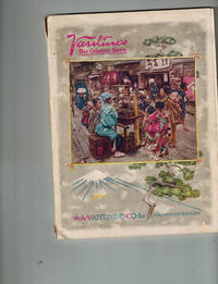
1916007165New York: A.A. Vantine & Co. Inc. 1916. A RARE catalogue and in lovely condition of the major importer of Oriental goods into America from 1866 to 1921. Very Good Plus in original full color pictorial wrappers 120 pp. plus 2 order pages at rear pre-addressed envelope tipped at page 106. numerous black and white and color photographs throughout small tears at spine ends small spot rear wrapper else Near Fine. In 1916 Vantine's was located at Fifth Avenue and 39th Street. Clothing furniture housewares fabric toys and other merchandise imported from China and Japan are described in the catalogue and merchandise from Vantine's has been avidly collected over the years. Worldcat locates no copies of the 1916 edition. . First Edition. Pictorial Printed Wrappers. Very Good Plus/No Jacket As Issued. 8vo - over 7¾" - 9¾" tall. A.A. Vantine & Co., Inc. Paperback books
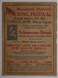
1918009861San Francisco: Walter N. Brunt Press 1918. Book. Very Good. Newsprint. First Printing. 14" x 10 1/2". 14" h x 10 1/2" w World War One broadside printed on newsprint by Walter N. Brunt Press 880 Mission St. S.F. No year given but 1918. Very Good small edge tears and chips light creasing. Billed as the "Greatest Open Air Concert Ever Held in America" with "17000 Good Seats". Presented "under the auspices of War Camp Community Service Commission and Leland Stanford University" The "Proceeds to be devoted to the development of the recreational facilities of the men at Camp Fremont and to sending the fifteen women graduates of Stanford University to France for War Service". RARE. OCLC locates no copies although Stanford University Library holds the program and song sheet for this event. Walter N. Brunt Press unknown
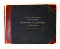
190121432Nueva York: Polhemus y Compania 1901. First Edition. Hardcover. Good. Title continues: Tomadas por parte de México Bajo la Dirección del Ingeniero Jacobo Blanco Jefe de la Sección Mexicana de la Comisión Internacional de Limites que Restablecio los Monumentos en Anos de 1892 a 1895. 11 x 14 inches oblong in original black cloth with red leather spine and corners marbled edges and endpapers. Title stamped in gilt on upper board and spine. Also designated "Vol. III" on spine. Front board and first few leaves detached but present rear hinge cracked. Text block otherwise sound and quite clean. Title page and one-page introduction by Blanco are followed by 258 b/w half-tone plates showing all of the monuments along the U.S./Mexico border from El Paso to the Pacific. Many of the images include the surveyors and their equipment. "In the 1870s and 1880s land ownership and border disputes broke out when valuable natural resources were discovered near the United States-Mexican border. The International Boundary Commission which set out in 1891 consisted of two main parties one from the U.S. and one from Mexico. John Whitney Barlow and Jacobo Blanco respectively U.S. and Mexican commissioners met at El Paso in February 1892 to begin the work. Their instructions were to resurvey the border line locate and rebuild the old monuments and install additional markers as necessary" Smithsonian. This album is the Spanish-language equivalent with the same plates of "Report of the Boundary Commission Upon the Survey and Re-Marking of the Boundary Between the United States and Mexico West of the Rio Grande 1891-1896: Album" published by the U.S. Government Printing Office in 1899. Polhemus y Compania hardcover
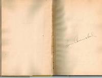
1946005337New York: Rinehart & Co. 1946. SIGNED BY AUTHOR and Bloomington Indiana's legendary composer and actor Hoagy Carmichael on front end page. Very Good slight spine lean boards a bit soiled in a Very Good priced dust wrapper rear panel soiled and minor edge wear. An uncommon SIGNED BY AUTHOR copy !. SIGNED BY AUTHOR. First Edition. Cloth. Very Good/Very Good. 8vo - over 7¾" - 9¾" tall. Rinehart & Co. Hardcover books
1875013880Philadelphia: J. B. Lippincott 1875 Philadelphia: Lippincott 1875. First Edition second printing. 8vo. 3 volumes Decorative cloth gilt titles 579 547 542 pp. This is the first time Franklin's autobiography with the addition of relevant correspondence collected by Bigelow was printed from the actual holograph ms. Frontispiece portrait of Franklin protective tissue in Volume I. Third volume has previous owner bookplate and signature on second free front endpaper. Shallow chipping top of spine. Volume III has minor wrinkle to cloth chip to rear free endpaper. Very good. J. B. Lippincott hardcover
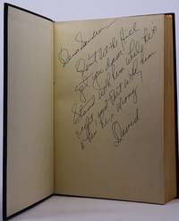
1972010115New York: Random House 1972. Book. Very Good. Cloth. SIGNED AND INSCRIBED BY AUTHOR. First Edition. 8vo - over 7¾" - 9¾" tall. Presentation Copy SIGNED AND INSCRIBED BY AUTHOR at front end page -"Dear Sandra Don't let the Hill get you down. Stand with him while he's right and part with him when he's wrong. David". A great political Association Copy Sandra obviously being a Congressional staffer known to the author given his use of first names only. The Pulitzer Prize-winning journalist best known work his chronicle of what went wrong in Vietnam Very Good boards ligtly soiled in a Very Good dust jacket light war at edges front flap vertical creases. Random House Hardcover
180622543Philadelphia: B. Graves 1806. First Edition. Hardcover. Very good. 8vo pp v 1648 index with one folding table in original full calf with red spine label. Leather scuffed corner torn from table with small loss of text otherwise sound and clean. Bookplate of Benjamin Lincoln Lear 1792-1832 attorney and godson of George Washington on front pastedown three manuscript notes in Lear's hand and several newspaper clippings laid in -- all relating to gardening. "M’Mahon came from Ireland in 1796 and began to collect and export seeds of native American plants in 1800. His catalog of 1804 listed seeds of about 1000 species. In 1806 he published his book The American Gardener’s Calendar that was for 50 years the standard gardening authority in America. There were eleven editions of his book by the last edition published in 1857. A general catalog of garden plants was published at the end of the book. He knew Jefferson and his store became the meeting place of botanists and horticulturists. M’Mahon helped to distribute the seeds collected by the Lewis and Clark Expedition" Smithsonian. The book's lengthy subtitle offers a good explanation of its content: "Containing a complete account of all the work necessary to be done in the kitchen-garden fruit-garden orchard vineyard nursery pleasure-ground flower-garden green-house hot-house and forcing frames for every month of the year; with ample practical directions for performing the same. Also general as well as minute instructions for laying out or erecting each and every of the above departments according to modern taste and the most approved plans; the Ornamental Planting of Pleasure Grounds in the ancient and modern style; the cultivation of Thorn Quicks and other<br /> plants suitable for Live Hedges with the best methods of making them &c. To which are annexed catalogues of Kitchen Garden Plants and Herbs; Aromatic Pot and Sweet Herbs; Medicinal Plants and the most important Grapes &c. used in rural economy; with the soil best adapted to their cultivation." Benjamin Lincoln Lear was the only son of President George Washington's secretary Tobias Lear and was born in Washington's house in Philadelphia. He became a prominent attorney in the District of Columbia. The three manuscript notes laid into this book pertain to gowing asparagus and to gardening tasks for the end of the growing season. B. Graves hardcover
187936096Washington D.C.: General Land Office printed in New York by Julius Bien lithographer 1879. Color-lithographed map. A very detailed colour-coded map of Illinois showing towns rivers roads railroads among other landmarks.<br/> <br/> The General Land Office was founded in 1812 as an independent government agency responsible for the surveying and disposition of land in the public domain. Prior to the Civil War much of the attention of the GLO was fixed on the settlement of such land east of the Mississippi which had resulted from military bounties and cessations by the original thirteen states. The end of the Civil War the Homestead Act the completion of the Trans-Continental Railroad and the military campaigns against Native Americans in the West with resulting treaties that "transferred" land ownership to the United States together engendered an incredible increase in westward settlement and expansion. Newly-admitted states and newly-created territories west of the Mississippi were primed for settlement. Between 1866 and 1876 the GLO surveyed over 200000000 acres of land in the public domain for settlement in New Mexico Idaho Dakota Nebraska Montana Colorado Wyoming and elsewhere. As the official surveyors of these remote areas and with access to military information the maps of the General Land Office were far and away the most accurate and detailed of the western states and territories published to that time. Indeed these large-scale official maps became the basis for future maps of those regions by commercial cartographers. In 1876 the GLO headed by S.S. Burdett published an atlas containing 18 maps on 19 sheets California being on two sheets showing the regions of the United States with newly surveyed and plotted public lands. Although the GLO had issued individual maps of the United States to accompany their annual report in 1866 and 1868 the 1876 Geographical and Political Atlas of the States and Territories sometimes referred to as The Centennial Atlas was the first atlas to be published by the department. The incredible growth of settlement in the west coupled with new exploration and surveying in the short time following the 1876 atlas engendered a second atlas to be published by the General Land Office between 1878 and 1879 i.e. where the present example is from. Like the Centennial Atlas the maps were composed by the chief draughtsman in the GLO Charles Roeser Jr. The maps were done on a large scale and are consequently very detailed. Chromolithographed by Julius Bien each map is colour coded to clearly depict land plotted for settlement the locations of the general land offices Indian territories county divisions towns rivers roads railroads etc. Furthermore like The Centennial Atlas the Atlas of the States and Territories over which Land Surveys have been Extended was produced for official purposes and distributed to members of Congress government agencies each land office the post office the railroads and other large entities and was not available for public distribution. The limited distribution of this atlas coupled with its large size accounts for its great rarity today; very few copies are known to be in private hands and no copies were in the famed collections of Rumsey Streeter or Graff.<br/> <br/> Phillips Atlases 1405. General Land Office [printed in New York by Julius Bien, lithographer] unknown
187936099Washington D.C.: General Land Office printed in New York by Julius Bien lithographer 1879. Color-lithographed map. A very detailed colour-coded map of Ohio showing towns rivers roads railroads among other landmarks.<br/> <br/> The General Land Office was founded in 1812 as an independent government agency responsible for the surveying and disposition of land in the public domain. Prior to the Civil War much of the attention of the GLO was fixed on the settlement of such land east of the Mississippi which had resulted from military bounties and cessations by the original thirteen states. The end of the Civil War the Homestead Act the completion of the Trans-Continental Railroad and the military campaigns against Native Americans in the West with resulting treaties that "transferred" land ownership to the United States together engendered an incredible increase in westward settlement and expansion. Newly-admitted states and newly-created territories west of the Mississippi were primed for settlement. Between 1866 and 1876 the GLO surveyed over 200000000 acres of land in the public domain for settlement in New Mexico Idaho Dakota Nebraska Montana Colorado Wyoming and elsewhere. As the official surveyors of these remote areas and with access to military information the maps of the General Land Office were far and away the most accurate and detailed of the western states and territories published to that time. Indeed these large-scale official maps became the basis for future maps of those regions by commercial cartographers. In 1876 the GLO headed by S.S. Burdett published an atlas containing 18 maps on 19 sheets California being on two sheets showing the regions of the United States with newly surveyed and plotted public lands. Although the GLO had issued individual maps of the United States to accompany their annual report in 1866 and 1868 the 1876 Geographical and Political Atlas of the States and Territories sometimes referred to as The Centennial Atlas was the first atlas to be published by the department. The incredible growth of settlement in the west coupled with new exploration and surveying in the short time following the 1876 atlas engendered a second atlas to be published by the General Land Office between 1878 and 1879 i.e. where the present example is from. Like the Centennial Atlas the maps were composed by the chief draughtsman in the GLO Charles Roeser Jr. The maps were done on a large scale and are consequently very detailed. Chromolithographed by Julius Bien each map is colour coded to clearly depict land plotted for settlement the locations of the general land offices Indian territories county divisions towns rivers roads railroads etc. Furthermore like The Centennial Atlas the Atlas of the States and Territories over which Land Surveys have been Extended was produced for official purposes and distributed to members of Congress government agencies each land office the post office the railroads and other large entities and was not available for public distribution. The limited distribution of this atlas coupled with its large size accounts for its great rarity today; very few copies are known to be in private hands and no copies were in the famed collections of Rumsey Streeter or Graff.<br/> <br/> Phillips Atlases 1405. General Land Office [printed in New York by Julius Bien, lithographer] unknown
187936095Washington D.C.: General Land Office printed in New York by Julius Bien lithographer 1879. Color-lithographed map. A very detailed colour-coded map of Wisconsin showing towns rivers roads railroads among other landmarks.<br/> <br/> The General Land Office was founded in 1812 as an independent government agency responsible for the surveying and disposition of land in the public domain. Prior to the Civil War much of the attention of the GLO was fixed on the settlement of such land east of the Mississippi which had resulted from military bounties and cessations by the original thirteen states. The end of the Civil War the Homestead Act the completion of the Trans-Continental Railroad and the military campaigns against Native Americans in the West with resulting treaties that "transferred" land ownership to the United States together engendered an incredible increase in westward settlement and expansion. Newly-admitted states and newly-created territories west of the Mississippi were primed for settlement. Between 1866 and 1876 the GLO surveyed over 200000000 acres of land in the public domain for settlement in New Mexico Idaho Dakota Nebraska Montana Colorado Wyoming and elsewhere. As the official surveyors of these remote areas and with access to military information the maps of the General Land Office were far and away the most accurate and detailed of the western states and territories published to that time. Indeed these large-scale official maps became the basis for future maps of those regions by commercial cartographers. In 1876 the GLO headed by S.S. Burdett published an atlas containing 18 maps on 19 sheets California being on two sheets showing the regions of the United States with newly surveyed and plotted public lands. Although the GLO had issued individual maps of the United States to accompany their annual report in 1866 and 1868 the 1876 Geographical and Political Atlas of the States and Territories sometimes referred to as The Centennial Atlas was the first atlas to be published by the department. The incredible growth of settlement in the west coupled with new exploration and surveying in the short time following the 1876 atlas engendered a second atlas to be published by the General Land Office between 1878 and 1879 i.e. where the present example is from. Like the Centennial Atlas the maps were composed by the chief draughtsman in the GLO Charles Roeser Jr. The maps were done on a large scale and are consequently very detailed. Chromolithographed by Julius Bien each map is colour coded to clearly depict land plotted for settlement the locations of the general land offices Indian territories county divisions towns rivers roads railroads etc. Furthermore like The Centennial Atlas the Atlas of the States and Territories over which Land Surveys have been Extended was produced for official purposes and distributed to members of Congress government agencies each land office the post office the railroads and other large entities and was not available for public distribution. The limited distribution of this atlas coupled with its large size accounts for its great rarity today; very few copies are known to be in private hands and no copies were in the famed collections of Rumsey Streeter or Graff.<br/> <br/> Phillips Atlases 1405. General Land Office [printed in New York by Julius Bien, lithographer] unknown
1809013879New York: G. Bunce for Evert Duyckinck 1809 First edition. 18mo. 144 pp. Sabin 101734 which notes that some copies had frontispiece portraits and some did not. This does not. Exceptionally charming hand-painted Pennsylvania Dutch design to boards Hand-printed "Nancy Ackley Her Book" on free front endpaper. Collection of documents written by Washington. Rubbing to boards light edgewear bumped corners. Near fine. G. Bunce for Evert Duyckinck hardcover
19266525Washington DC: Association for the Study of Negro Life and History 1926 . First edition. Hardcover. Very Good. Tall 8vo; xxxii 672 pages dark green cloth. Surprisingly scarce. <br/><br/> Blockson Collection 9703. Woodson has been called "the Father of Black History". This same year 1926 he initiated "Negro History Week". "The mind of a people the development of a public mind has become a new factor in historical interpretation. This factor is now being considered not only as important as the social political and economic but also as productive of these forces - Introduction." "These letters were reproduced just as they were found in the sources - Foreword." Association for the Study of Negro Life and History hardcover
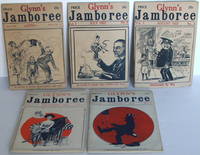
1922008900Yonkers NY: Harry A. Glynn. 5 original issues including the first three that were published. April July August December 1922 Vol. 1 Nos. 1236; January 1923; Vol. II No. 7. Published Yonkers NY: Harry A. Glynn 1922-1923. 12mo. stapled wrappers 5 1/4" x 7 3/4" each 32-34pp. plus 4pp. printed stiff covers illustrated. The first issue April 1922 was published as a quarterly with the July issue beginning the run as a monthly. The first two issues bear the cover subheading "In Favor of Booze Wild Women and Jazz" which was changed to "Intoxicated By Wit" with the August issue. With the January 1923 issue it changed again to "A Magazine That's Intoxicated By Wit". Sections include Eve And Her Sex; Some Redhead Pickings; Information Worthwhile; Private Questions; Verse Or Worse. The second issue began carrying small display ads for risqué photos on the last page. "Eat drink raise hell and be merry and tomorrow you can tell it to the Judge." A quirky publication. All very good to near fine. Rare. Only two issues in World Cat. . Very Good. Soft cover. 1st. 1922. Harry A. Glynn paperback