West FloridaABAA
2 245 résultats
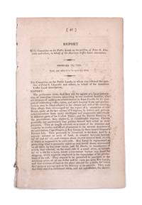
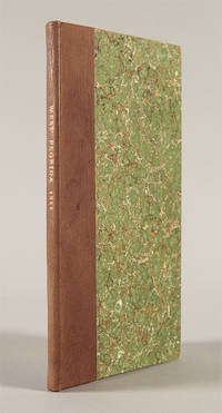
1811WRCAM41305Washington City: A. & G. Way 1811. 11pp. Modern half calf and marbled boards. Lightly foxed. Very good. The report of the congressional committee appointed to evaluate the government of Mississippi Territory and the petition of the residents of West Florida what is now the southernmost portions Mississippi and Alabama to be annexed to that territory. The United States had supported the bloodless coup of Americans resident in what was then Spanish territory and annexed the land over Spain's bitter protests. Given the commercial stranglehold New Orleans and Louisiana would have on the region if West Florida were annexed to it thus giving Louisiana almost exclusive access to the Gulf the committee relying heavily on recent census data recommends that Mississippi be admitted to the Union and that West Florida as defined in the 1763 Treaty of Paris be annexed to it. The argument concludes: "The formation of new states on the southern extremity of the United States ought not to be delayed." An important step forward in the development of the Deep South. Scarce. SHAW & SHOEMAKER 24296. A. & G. Way hardcover books
Raffigurazione geografica del territorio nord americano in particolare di Canada o Nouvelle France ed una parte degli Stati Uniti (Florida, Carolaina, Luisiana, Virginia...). Interessante evidenziare come l'estensione del Canada venga aumentata, verso sud, a discapito dei territori delle colonie inglesi.
In-4°, due volumi, (5), CCXLII, 413, due carte pieghevoli (La Florida en el ano 1591, La Florida en el ano 1765), tavole; pp 801 Rilegatura in mezza pergamena con tasselli al dorso. Pedro Menendez de Aviles fu il primo governatore spagnolo della Florida, capo generale dell’Armada contro l’Inghilterra In-4°, two volumes, (5), CCXLII, 413, two folded maps (La Florida en el ano 1591, La Florida en el ano 1765), plates, pp 801. Half parchemine binding. Pedro Menendez de Aviles was the first Spanish governor of Florida, Chief General of the Armada against England
1465258868-11-18Kendall Hunt. 2nd. Very Good. It's a well-cared-for item that has seen limited use. The item may show minor signs of wear. All the text is legible with all pages included. It may have slight markings and/or highlighting. Kendall Hunt unknown
192140736Washington D.C.: Published by the United States Coast and Geodetic Survey 1921. Large folding nautical chart printed on heavy paper stock. Colored. A rare original coastal survey of Florida and Alabama from Pensacola Bay showing Perdido Bay including Pensacola Perdido Key and Orange Beach.<br/> <br/> Established by President Thomas Jefferson in 1807 as the Survey of the Coast the U.S. Coast and Geodetic Survey was the United States' first civilian scientific agency. This agency has followed its mission to survey the U.S. coastline create nautical charts of the coast and help increase maritime safety since its founding and has often played fascinating roles in significant chapters of U.S. history. It served in all theaters of the Civil War in the service of the Union Army and Navy pioneered acoustic exploration in the wake of the sinking of the Titanic and during WWI it worked to detect enemy submarines. In addition this agency worked to survey and produce detailed maps and renderings of the U.S. coast. These nautical survey maps commonly referred to as "T-sheets" provide fascinating insights into the history of the United States coastline which has and will continue to shift. These maps are the most important data source for understanding the physical and ecological characteristics of the U.S. shoreline. The present map is a highly detailed and accurate sea chart of the coastal border between Florida and Alabama and an important historical view of the developing states. Published by the United States Coast and Geodetic Survey unknown
191740710Washington D.C.: Published by the United States Coast and Geodetic Survey 1917. Folding nautical chart printed on heavy paper stock. Uncolored. A rare original coastal survey of Florida's Cedar Keys area.<br/> <br/> Established by President Thomas Jefferson in 1807 as the Survey of the Coast the U.S. Coast and Geodetic Survey was the United States' first civilian scientific agency. This agency has followed its mission to survey the U.S. coastline create nautical charts of the coast and help increase maritime safety since its founding and has often played fascinating roles in significant chapters of U.S. history. It served in all theaters of the Civil War in the service of the Union Army and Navy pioneered acoustic exploration in the wake of the sinking of the Titanic and during WWI it worked to detect enemy submarines. In addition this agency worked to survey and produce detailed maps and renderings of the U.S. coast. These nautical survey maps commonly referred to as "T-sheets" provide fascinating insights into the history of the United States coastline which has and will continue to shift. These maps are the most important data source for understanding the physical and ecological characteristics of the U.S. shoreline. The present map is a highly detailed and accurate sea chart of Florida's Cedar Keys and an important historical view of a developing Florida. Published by the United States Coast and Geodetic Survey unknown
191740726Washington D.C.: Published by the United States Coast and Geodetic Survey 1917. Nautical chart printed on heavy paper stock. Uncolored with minor wear. A rare original coastal survey of the Legare Anchorage in Florida's Biscayne Bay with Elliot Key and Sands Key.<br/> <br/> Established by President Thomas Jefferson in 1807 as the Survey of the Coast the U.S. Coast and Geodetic Survey was the United States' first civilian scientific agency. This agency has followed its mission to survey the U.S. coastline create nautical charts of the coast and help increase maritime safety since its founding and has often played fascinating roles in significant chapters of U.S. history. It served in all theaters of the Civil War in the service of the Union Army and Navy pioneered acoustic exploration in the wake of the sinking of the Titanic and during WWI it worked to detect enemy submarines. In addition this agency worked to survey and produce detailed maps and renderings of the U.S. coast. These nautical survey maps commonly referred to as "T-sheets" provide fascinating insights into the history of the United States coastline which has and will continue to shift. These maps are the most important data source for understanding the physical and ecological characteristics of the U.S. shoreline. The present map is a highly detailed and accurate sea chart of the Biscayne Bay region and an important historical view of a developing Florida. Published by the United States Coast and Geodetic Survey unknown
191740713Washington D.C.: Published by the United States Coast and Geodetic Survey 1917. Large folding nautical chart printed on heavy paper stock. Uncolored. Coastal survey map of Tortugas Harbor and approaches with an inset map in the upper left corner of Fort Jefferson.<br/> <br/> Established by President Thomas Jefferson in 1807 as the Survey of the Coast the U.S. Coast and Geodetic Survey was the United States' first civilian scientific agency. This agency has followed its mission to survey the U.S. coastline create nautical charts of the coast and help increase maritime safety since its founding and has often played fascinating roles in significant chapters of U.S. history. It served in all theaters of the Civil War in the service of the Union Army and Navy pioneered acoustic exploration in the wake of the sinking of the Titanic and during WWI it worked to detect enemy submarines. In addition this agency worked to survey and produce detailed maps and renderings of the U.S. coast. These nautical survey maps commonly referred to as "T-sheets" provide fascinating insights into the history of the United States coastline which has and will continue to shift. These maps are the most important data source for understanding the physical and ecological characteristics of the U.S. shoreline. The present map is inset with a detailed view of Fort Jefferson on Garden Key. Fort Jefferson was an ambitious civil war era coastal defence site which became the largest brick structure in the US. This map is a highly detailed and accurate sea chart of Tortugas Harbor and an important historical view of a developing Florida. Published by the United States Coast and Geodetic Survey unknown
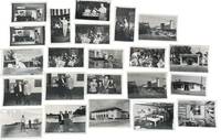
1950233201950. Clearwater Florida photo archive by George Fulmer documenting a Gulf Coast city in the early postwar Sunbelt boom: downtown storefronts automobile traffic tourism businesses beauty shops laundromats pharmacies loan offices civic buildings youth music programs local entertainments and everyday commercial life. George Fulmer identified here through the studio sleeves and the Clearwater job file context worked as a commercial and civic photographer in a period when Pinellas County grew quickly with new residents new retail construction and an increasingly car centered downtown. <br /> <br /> Photo archive of 70 items including 34 silver gelatin photographs with 36 corresponding and unique large format negatives contained in 15 studio sleeves with some annotations ranging from 3" x 5" to 4" x 5" Clearwater Florida circa early 1950s. Storefronts and signs identify Billie Moran Hair Stylist Spotlite Cleaners Launderette Family Loan Co. Loans Lane's Pharmacy Harris Drive In Pharmacy and a downtown block with the Capitol Theatre marquee and McCrory's along a traffic-filled street. Other scenes include audio equipment demonstrations musicians performing before seated audiences children handling rabbits a youth band rehearsal commercial laundry workers golfers near a clubhouse and staged presentation or prize events. Original sleeves strengthen the local identification with handwritten client names addresses dates and job numbers including "Portal Office U.S. Post Office" "P.G.A. Clinic" "Family Loan Office" "Lane Pharm" "Harris Pharmacy" and "Helpy Selfy Laundry." More scenes place people inside the social and commercial interiors of the city: a woman stands beside a microphone while another plays piano; accordion players and guitarists perform before a seated audience in a hall draped with streamers; children and an adult handle rabbits in what appears to be a club or youth program setting; a school band director leans into a room packed with young musicians and music stands; workers stand at wash stations in a commercial laundry; golfers pose and shake hands near a clubhouse; a woman and man stand on a small platform before a seated crowd during what appears to be a staged presentation or prize event.<br /> <br /> These scenes belong to the years when Florida's west coast cities were advertising modern storefronts widening their commercial appeal and absorbing the population growth that followed World War II air conditioning road building and the state's aggressive promotion of itself as a place to live shop vacation and retire. For institutional collections the group supplies named evidence of how a single city looked and conducted business during the first great Sunbelt surge: not only landmark buildings and downtown traffic but service counters display windows local entertainment children's programs and the ordinary businesses that usually vanish first from the record. Light wear minor surface handling and expected age toning to prints and negatives with some sleeves worn from studio use; overall in very good condition. A strong regional archive of Clearwater's commercial and civic life still anchored to the working paperwork that identifies who hired Fulmer and what parts of the city he was asked to record. unknown
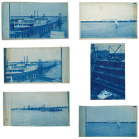
18953633601895. Five views of Lake Worth Beach and Palm Beach in 1895.<br /> <br /> The images are:<br /> <br /> 1 Ferry at Lake Worth with the Royal Poinciana Hotel in the distance. Captioned in the negative "L.W.B. 9.14.95";<br /> 2 Lake Worth with the Royal Poinciana Hotel in the distance. Captioned in the negative "L.W.B. 9.24.95";<br /> 3 View of Lake Worth with a pier in the foreground possibly taken from a boat. Captioned in the negative "L.W.B. 10.9.95";<br /> 4 Sail boat in front of the Royal Poinciana captioned in the negative "Lake Worth" two versions with different exposure times<br /> 5 View of the Palm Beach Inn later renamed The Breakers under construction with the Royal Poinciana in the background not dated but the hotel opened in December 1895.<br /> <br /> The negatives these views were printed from are of somewhat unusual size measuring roughly 4-3/4 by 7-3/4 inches. All but one view have a horizontal orientation. Given that this size does not seem to conform to the standard halfplate negative usually 5-1/2 to 6-1/2 inches in the long direction one might speculate that the photographer made their own camera. The photographs are handcut with somewhat uneven edges and of varying finished sizes all roughly 5 by 8 inches. They are generally very good or better with some toning and spotting. Uncommon subject matter. unknown
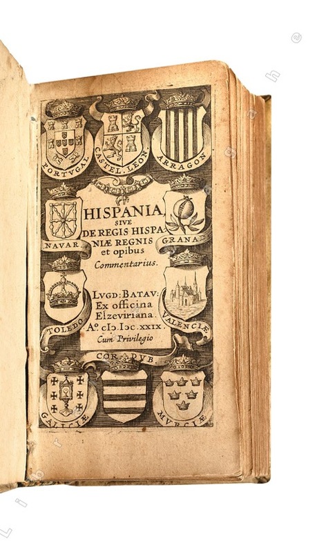
162921438Lugd. Batav. (Leyde), ex officina Elzeviriana, 1629 ; in-24 (108 mm), vélin rigide de l’époque, titre manuscrit au dos ; [16], 498 pp., [1] f. de Privilège, titre gravé illustré de blasons.
1959ZB705266Florida Association of Architects / Roger W. Sherman 1959. Volumes 9 through 26 1959-1976 lacking volume 11#11; 12#12; Bound in buckram with original covers included except for the issues for volume 11 & 12 which are unbound in original wrappers. Ex library text clean & bindings tight. - If you are reading this this item is actually physically in our stock and ready for shipment once ordered. We are not bookjackers. Buyer is responsible for any additional duties taxes or fees required by recipient's country. Photos available upon request. Florida Association of Architects / Roger W. Sherman hardcover
Mm 220x320 Cinque volumi rilegati in mezza pelle, titolo e fregi in oro al dorso, piatti con carta marmorizzata con piccole abrasioni alla base. Legature tutte ben salde. Vol. I°, ( 2 Luglio - 24 dicembre 1968 ) di 414 pp. Vol. II°, ( 1° gennaio - 24 giugno 1969 ) di 414 pp. Vol. III°, ( 1° luglio - 30 dicembre 1869 ) di 430 pp. Vol. IV°, ( 6 gennaio - 30 giugno 1870 ) di 414 pp. Vol. V°, ( 7 luglio - 29 dicembre 1870 ). Tutti i volumi sono illustrati da xilografie con immagini anche a piena pagina. Alcune fioriture e bruniture in alcune pagine del testo, peraltro lo stato d'insieme di questo importante settimanale, di forte caratterizzazione eurocentrica, è ottimo. Raccolta di tutto il pubblicato della nota rivista a carattere geografico che seguì la edizione di lusso orientata ad un pubblico più facoltoso e che venne poi continuata e surrogata col nuovo anno dal " Giornale popolare di Viaggi". Spedizione in 24 ore dalla conferma dell'ordine.
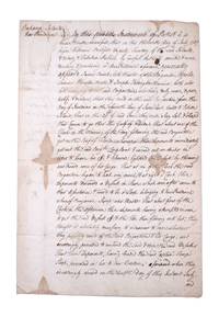
1767351783New Providence Bahamas 1767. 2pp folded folio sheet with integral blank. Old folds minor staining. 2pp folded folio sheet with integral blank. The Brigatine Apollo left the bay of Honduras on 11 June 1767 bound for Rhode Island on a course through the Gulf of Florida. "That about one of the clock in the morning of the day following the said Brigantine got on the reef of Florida whereupon the deponents immediately got out the said Brig.t's long boat and carried out an anchor in order to heave her off & likewise lightened the vessell by throwing over board some of her cargo: That at six of the clock the said brigatine began to leak very much & at eight o'clock these deponents discovered a vessell in shore which soon after came to their assistance & prov'd to be a sloop belonging to New Providence . having attempted in vain to get the said vessell off & the tide then flowing into her they thought it absolutely necessary to endeavor to save whatever they possibly could of the said Brigatine & her cargo and accordingly proceeded to unbend the sails & strip the said vessell . and do hereby solemnly protest aginst the said reef of Florida for all losses damages & expences hitherto sustained thereby ." <br /> <br /> The document does not specify the nature of the cargo going from British Honduras to Rhode Island but was perhaps mahogany or other timber used in colonial New England for cabinet making. unknown
1822339148Washington D.C.: Gales & Seaton 1822. 17th Congress 1st Session House Report No. 47. 35 1 blankpp. 8vo. Disbound. 17th Congress 1st Session House Report No. 47. 35 1 blankpp. 8vo. A request that the association formed by Chazotte be allowed to purchase land in the Key Largo area for the purpose of cultivating coffee cocoa and tropical fruits. Pages 13 through 30 comprise a separate section with its own caption title: Facts and Observations on the Culture of Vines Olives Capers Almonds &c. in the Southern States and of Coffee Cocoa and Cochineal in East Florida. This section first published separately in Philadelphia in 1821. Shoemaker 11210 [Gales & Seaton] unknown
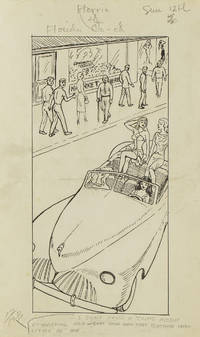
1949313357Gainesville Fla 1949. Aprox 77 pen and ink drawings with the newspaper cliping done generally for Wednesdays and Sundays. 8vo & 4to. In spiral rink notebook. Aprox 77 pen and ink drawings with the newspaper cliping done generally for Wednesdays and Sundays. 8vo & 4to. unknown
192264060Tallahassee FL & Buffalo & New York NY: Department of Agriculture Florida The Matthews-Northrup Works 1922. One large oblong double-atlas folio colour lithograph map sized 50 x 44 in. county lines and railroad lines demarcated in colours fold creases as issued minor dustsoiling edgewear to verso some very slight weakening to a couple fold creases otherwise a VG bright copy. First edition thus of this uncommon and updated sectional map of Florida incorporating the 1920 census numbers as well as updating the agricultural statistics farm properties and average acreage values at the outset of the Roaring 20’s. Also delineated are the railroads reaching into Florida including the Atlantic Coast Line Florida East Coast RR Seaboard Air Lines Georgia Southern & FLorida RR Louisville 7 Nashville RR and others. McRae 1870-1943 headed the Florida Department of Agriculture from 1912-1923. Worldcat locates 2 physical copies U of FL WI Hist. Soc. Department of Agriculture, Florida, The Matthews-Northrup Works, unknown
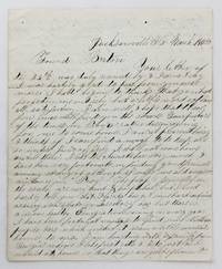
18584106Jacksonville Fl: March 15 1858. Very good plus. 4pp. on a single folded sheet. Old mailing folds. An informative dispatch from antebellum Florida from A.C Scranton to "Friend Barton" in 1858. In his letter Scranton reports that despite some problems he is enjoying southern people and general life in Florida: "The people generally in the south are very kind & hospitibal but I need hardly to tell you that Florida has got some hard times as every new state or Territory has but thare is a more healthy Emigration coming in every year I have been fortunate anough to find some Northern people here which makes it seam a little more like home to me. I am boarding with a family from Georgia whome I like first rate & I do just as I would at home so that things are quite pleasant here considering I am amongst strangers."<br /> <br /> He then provides information on Jacksonville and then two disasters that hit his adopted hometown: "Jacksonville is the largest place in Florida & had at one time about 3000 inhabitants it is not as large as it was once some three years ago it was visited by a very destructive fire & burned nearly half of the town. Last summer there was some kind of Fever here that almost prostrated the place some called it the Yellow Fever & some the African but none could tell for certin.about a hundred & fifteen or twenty that died here in 3 months & a grate many left the town nearly all the stors wer closed not a sound of a hammer was to be heard. When cold weather came it stoped the sickness and it seams quite lively now. It has been for many years a grate resort in the winter season for invaleds but on account of the sickness last summer thare are but few this winter if it continus healthy this summer the place will revive but if not it will kill it entirely."<br /> <br /> Scranton also discusses the transportation system that served Jacksonville and the recent winding down of the Seminole Wars: "It is situated on the Johns River about 23 miles from the mouth and is connected with Charleston & Savana by a regular line of steamers that runs up the river a hundred miles to a place called Platka whare Emigrants land & then travel by land to the interior to settle the country thare is a railroad building from this place to Tallahasse the capital of the state a distance of a hundred & eighty miles which wen completed will be a little help to this place. There is also another in progress from Fernandina a new town that lays in the North East corner of the state to a place called cedar keys on the gulf side whare they intend to carry the US mail direct from New Orleans to New York insted of going round by Key west & will shorten the time considerable. Florida has cost Uncle Sam a large some of money.the government.will make a treaty with them & send them into the Indian Territory & then close the Indian war in Florida." Almost all of the Seminoles remaining in Florida relocated to Indian Territory in the year this letter was written.<br /> <br /> A wonderfully-detailed firsthand account of Jacksonville and its development and challenges during the late 1850s. A printed transcription accompanies the letter. March 15 unknown
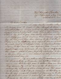
184635409Pensacola 1846. Letter. Very good. Letter. 4 pages. Lined paper folded. 4 pages of content. Postal mark and address written center of the 4th page. Two small wax seals on the edges of page 4. <br /> <br /> Letter is addressed to William Roney Jr. Corner of Third & Branch Sts Philadelphia Pa. Letter written aboard the U.S. Frigate "Raritan" off Pensacola Navy Yard April 3rd 1846 and has a Pensacola post mark and date of April 6 . Written on the eve of the Mexican War April 24 1846 to February 2 1848. Content summarized:<br /> <br /> Thomas Roney Midshipman writes a lengthy letter to his brother about his situation in Pensacola and requests his brother's help with family debts. He writes:“There is very little news from Mexico the latest is that Mr. Slidell has been informed that the government could not receive a Minister from the United States but that there were ready to receive a Commissioner for the settlement of the Texas question. We had consequently demanded his passports and is expected here very shortly in the Ship Manzo. The Mexicans have been making every preparation for a war…were preparing to place Santa Anna at the head of the government again….†Roney had been transferred from the U.S. Brig Bainbridge back to the Raritan. He was relieved as “master†and appointed "midshipman". Roney has no problem with this because the Raritan is more comfortable. Roney recently returned from Rio de Janerio and had to take large advance to pay off debts. The only regret of his demotion to midshipman is that he can’t send money home to Mother any more hopes brothers can make it up. He complains of the cost of his “mess bill†and outfitting upon leaving the coast of Brazil. He writes "Any place is better than the coast of Brazil unknown
1949313357Gainesville Fla 1949. Aprox 77 pen and ink drawings with the newspaper cliping done generally for Wednesdays and Sundays. 8vo & 4to. In spiral rink notebook. Aprox 77 pen and ink drawings with the newspaper cliping done generally for Wednesdays and Sundays. 8vo & 4to. unknown books
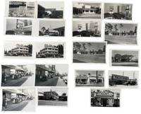
1950233171950. American postwar economic growth and tourism throughout Clearwater Florida photographed by local photographer George Fulmer showing how the Sunbelt expansion operated through roadside motels downtown retail waterfront leisure automobile traffic and service businesses during the rapid growth of the 1950s. The photographs center on the commercial circulation that made Clearwater function as a visitor city spanning rate signage pitched to seasonal travelers motel courts arranged for car access beach parking filled with mid-century automobiles storefront streets where shoppers and pedestrians occupy the sidewalk and crowded dock scenes tied to marine recreation. Clearwater had developed as a resort community by the 1890s and local historical sources note that by 1957 it was known as the fastest growing city in America making this group a concentrated record of the urban and commercial expansion that turned Pinellas County's Gulf Coast into a major tourism economy. <br /> <br /> Photo archive of 72 items including 38 silver gelatin photographs and 34 negatives ranging from 3" x 4" to 4" x 5" contained in 10 photo studio envelopes. Most negatives are duplicates of the print photographs while some are unique images. Clearwater Florida c. 1950s. Repeated and variant views show commercial properties and tourist infrastructure from multiple angles including motels with bold seasonal signage reading "SUMMER RATES $5.00 PER COUPLE FROM APRIL 15 TO NOV. 15" "20 ROOMS $4.00 DOUBLE Apr. 1st-Dec. 1" and "REASONABLE RATES 4 UNITS $5.00 DOUBLE APRIS-JUN." Several prints and negatives picture motel exteriors room interiors with twin beds and lamps a modernist multi-story lodging property with projecting sign and glass-fronted office and a low roadside restaurant or motel building beneath a large fish sign. Other images move into the wider tourist economy: downtown street scenes with McCrory's and Maas Brothers Television signage a storefront reading "Clearwater's American Casuals" a Parsons Paint Co. facade a Brookside Service Travel Gas station advertising regular gasoline at 26 cents and waterfront scenes with rows of parked cars palm-lined drives crowded piers and a dock packed with men women and children waiting or disembarking. The negatives preserve the same emphasis on repeated commercial views indicating studio production for advertising promotional or business use; the group also retains photo studio envelopes inscribed by George Fulmer.<br /> <br /> These photographs place Clearwater within the broader postwar reordering of Florida's Gulf Coast where automobile ownership road travel beach recreation and commercial real estate development produced the built environment commonly identified with Sunbelt growth. Fulmer's images are strongest where they show the interdependence of businesses rather than isolated structures: lodging needed seasonal pricing and motor access downtown retail depended on pedestrian density and curbside traffic waterfront tourism required parking and dock circulation and roadside services converted through-travel into local spending. Visible edge wear light curling and routine handling marks to some prints and negatives; studio envelopes present. Overall good condition. A substantial visual record of how Clearwater's postwar visitor economy operated on the ground with concrete evidence of the businesses prices streets interiors and waterfront traffic that made tourism an urban system rather than a backdrop. unknown
3242Scarce. Black paper wraps. Photograph and title printed in silver to front cover. Front fly made of silver paper. Organized by architect featuring photographs renderings and floorplans of commercial and residential projects located in South Florida including Miami Miami Beach Coral Gables Ft. Lauderdale and Palm Beach; Hobe Sound and Winter Park circa mid/late 30's. Last third of book consists of advertisements for architects contractors designers landscapers and building materials and manufacturers. A nice clean crisp copy without previous owners' names or other markings. ; 4to 11" - 13" tall; 106 54 pages; All shipments through USPS insured Priority Mail. The Miami Visitor Publishing Co., Inc. paperback
1986x-0471826456Wiley-Interscience 1986. Hardcover. New. 1st edition. 594 pages. 10.00x7.00x1.50 inches. Wiley-Interscience hardcover
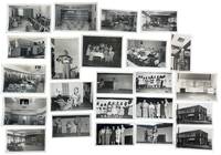
1951233191951. George Fulmer photographs of Clearwater residents businesses club spaces and service interiors recording how the residential economy of postwar Clearwater Florida functioned during early Sunbelt expansion in the 1950s. Fulmer a WWII U.S. Navy enlisted photographer and Clearwater city photographer for more than six decades worked from a studio beside the courthouse and produced a continuous visual record of the city's built environment commercial life and civic spaces; this group preserves that local documentary practice in a concentrated run of early postwar assignments tied to dining rooms lounges staged programs domestic instruction storefront promotion and everyday services. The material shows the interlocking spaces that supported residential growth in Pinellas County: hospitality rooms utility demonstrations cleaners and tailoring shops club events leisure scenes and communal interiors built for a city expanding through retirement migration consumer services and year-round settlement.<br /> <br /> Photo archive of 75 items including 36 silver gelatin photographs and 39 large format duplicate and original negatives ranging from 3 x 4 inches to 5 x 4 inches all contained in 12 original studio envelopes with some annotations by George Fulmer. Clearwater Florida and nearby Pinellas County circa 1951-1953. The most vivid images center on stage performance and organized social programming: women posed onstage around a table with boxed goods and a large lamp presenting household furnishings in a display that links entertainment to domestic consumption; girls lined across a stage in dresses for a group performance; a young female solo performer standing at microphone or center stage; a mixed adult group assembled under stage lighting in what appears to be a presentation or awards moment; and a trio of female performers in matching dance poses. These theatrical scenes are matched by audience and setting views that show older men dining together in booths and at tables large lounge interiors arranged for conversation and gathering office and reception spaces a broad institutional kitchen a man on a ladder opening a ceiling hatch in a decorated hall a child holding a large fish outdoors and exterior views of a corner cleaners and tailoring shop with painted signage reading "EST. 1909 CLEANERS" and "TAILORING." Original studio envelopes retain Fulmer job numbers dates and handwritten identifications including "Hart Cleaners" "BPW Club" "Weekend in Clearwater" "Court Crest Room" "Bank Central Pinellas Largo" and "Pinellas Utility Co. Cooking School" placing the images within the working files of a commercial city photographer covering Clearwater's residential service and promotional life.<br /> <br /> In the years after World War II Florida's Gulf Coast cities grew through in-migration small-business development utility expansion hospitality design and new forms of residential settlement aimed at permanent and seasonal residents alike. Fulmer's photographs place Clearwater within that broader transformation at street level through the rooms services labor and public-facing businesses that made postwar residential growth workable as daily life rather than as abstract development. Some negatives with light damage; photographs very good negatives largely good overall. A coherent single-photographer group of original studio material from George Fulmer's Clearwater practice with negatives prints and job-envelope evidence intact. unknown
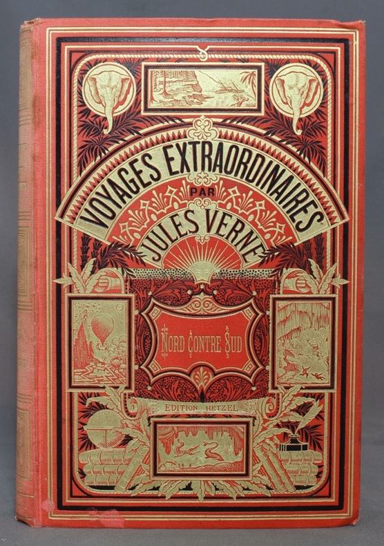
188710954Paris, Bibliothèque d'éducation et de récréation - Les Voyages extraordinaires, J. Hetzel et Cie, [1887]. Grand in-8 de [4]-416-7 (catalogue DS) pages, cartonnage rouge d'éditeur "aux deux éléphants" (type 3), second plat de type Lenègre "e" avec macaron central à fond noir. Dos passé, un coin légèrement tapé, 2 petites taches au bord inférieur du premier plat, pâles rousseurs, tampon de possesseur sur garde, faux-titre et page 1.