CAMUS (Armand-Gaston).Livre Rare Book
2 245 résultats
18020041271802 Paris, Baudouin, 1802. In-quarto (208 X 261) demi-veau fauve, dos lisse, frise et deux filets dorés en place des nerfs, pièce de titre maroquin rouge, tranches jaspées (reliure de l'époque); (2) ff. blancs, (2) ff. de faux-titre et titre, III pages de table, 401 pages, (2) pages d'errata, (3) ff. blancs.
191940735Washington D.C.: Published by the United States Coast and Geodetic Survey 1919. Large folding nautical chart printed on heavy paper stock. Colored. A rare original coastal survey of Florida and Georgia from Sapelo Island to Amelia Island including St. Simons Island Sea Island Brunswick Jekyll Island Cumberland Island and Fernandina Beach.<br/> <br/> Established by President Thomas Jefferson in 1807 as the Survey of the Coast the U.S. Coast and Geodetic Survey was the United States' first civilian scientific agency. This agency has followed its mission to survey the U.S. coastline create nautical charts of the coast and help increase maritime safety since its founding and has often played fascinating roles in significant chapters of U.S. history. It served in all theaters of the Civil War in the service of the Union Army and Navy pioneered acoustic exploration in the wake of the sinking of the Titanic and during WWI it worked to detect enemy submarines. In addition this agency worked to survey and produce detailed maps and renderings of the U.S. coast. These nautical survey maps commonly referred to as "T-sheets" provide fascinating insights into the history of the United States coastline which has and will continue to shift. These maps are the most important data source for understanding the physical and ecological characteristics of the U.S. shoreline. The present map is a highly detailed and accurate sea chart of the coastal border between Georgia and Florida and an important historical view of the developing states. Published by the United States Coast and Geodetic Survey unknown
191940687Washington D.C.: Published by the United States Coast and Geodetic Survey 1919. Nautical chart printed on heavy paper stock. Colored. A rare coastal survey of the Florida Georgia and South Carolina including Daytona Palm Coast St. Augustine Ponte Vedra Amelia Island Jacksonville Fernandina Jekyll Island St. Simons Sea Island Tybee Savannah Hilton Head Kiawah and Folly Beach.<br/> <br/> Established by President Thomas Jefferson in 1807 as the Survey of the Coast the U.S. Coast and Geodetic Survey was the United States' first civilian scientific agency. This agency has followed its mission to survey the U.S. coastline create nautical charts of the coast and help increase maritime safety since its founding and has often played fascinating roles in significant chapters of U.S. history. It served in all theaters of the Civil War in the service of the Union Army and Navy pioneered acoustic exploration in the wake of the sinking of the Titanic and during WWI it worked to detect enemy submarines. In addition this agency worked to survey and produce detailed maps and renderings of the U.S. coast. These nautical survey maps commonly referred to as "T-sheets" provide fascinating insights into the history of the United States coastline which has and will continue to shift. These maps are the most important data source for understanding the physical and ecological characteristics of the U.S. shoreline. The present map is a highly detailed and accurate sea chart of the coasts of Florida Georgia and Alabama and an important historical view of the developing states. Published by the United States Coast and Geodetic Survey unknown
192140692Washington D.C.: Published by the United States Coast and Geodetic Survey 1921. Nautical chart printed on heavy paper stock. Colored. A rare coastal survey of the Florida Keys including Key Largo Islamorada Long Key Marathon Key and Everglades National Park.<br/> <br/> Established by President Thomas Jefferson in 1807 as the Survey of the Coast the U.S. Coast and Geodetic Survey was the United States' first civilian scientific agency. This agency has followed its mission to survey the U.S. coastline create nautical charts of the coast and help increase maritime safety since its founding and has often played fascinating roles in significant chapters of U.S. history. It served in all theaters of the Civil War in the service of the Union Army and Navy pioneered acoustic exploration in the wake of the sinking of the Titanic and during WWI it worked to detect enemy submarines. In addition this agency worked to survey and produce detailed maps and renderings of the U.S. coast. These nautical survey maps commonly referred to as "T-sheets" provide fascinating insights into the history of the United States coastline which has and will continue to shift. These maps are the most important data source for understanding the physical and ecological characteristics of the U.S. shoreline. The present map is a highly detailed and accurate sea chart of BLANK and an important historical view of a developing Florida. Published by the United States Coast and Geodetic Survey unknown
191740708Washington D.C.: Published by the United States Coast and Geodetic Survey 1917. Large folding nautical chart printed on heavy paper stock. Colored with minor wear. A rare coastal survey of Florida from Port Canaveral to Vero Beach including Satellite Beach Melbourne and Palm Bay.<br/> <br/> Established by President Thomas Jefferson in 1807 as the Survey of the Coast the U.S. Coast and Geodetic Survey was the United States' first civilian scientific agency. This agency has followed its mission to survey the U.S. coastline create nautical charts of the coast and help increase maritime safety since its founding and has often played fascinating roles in significant chapters of U.S. history. It served in all theaters of the Civil War in the service of the Union Army and Navy pioneered acoustic exploration in the wake of the sinking of the Titanic and during WWI it worked to detect enemy submarines. In addition this agency worked to survey and produce detailed maps and renderings of the U.S. coast. These nautical survey maps commonly referred to as "T-sheets" provide fascinating insights into the history of the United States coastline which has and will continue to shift. These maps are the most important data source for understanding the physical and ecological characteristics of the U.S. shoreline. The present map is a highly detailed and accurate sea chart of the Florida coast and an important historical view of the developing state. Published by the United States Coast and Geodetic Survey unknown
191940701Washington D.C.: Published by the United States Coast and Geodetic Survey 1919. Large folding nautical chart printed on heavy paper stock. Colored. A rare coastal survey around Jacksonville including Fernandina Beach Amelia Island Jacksonville Atlantic Beach Neptune Beach Jacksonville Beach Ponte Vedra and Sawgrass.<br/> <br/> Established by President Thomas Jefferson in 1807 as the Survey of the Coast the U.S. Coast and Geodetic Survey was the United States' first civilian scientific agency. This agency has followed its mission to survey the U.S. coastline create nautical charts of the coast and help increase maritime safety since its founding and has often played fascinating roles in significant chapters of U.S. history. It served in all theaters of the Civil War in the service of the Union Army and Navy pioneered acoustic exploration in the wake of the sinking of the Titanic and during WWI it worked to detect enemy submarines. In addition this agency worked to survey and produce detailed maps and renderings of the U.S. coast. These nautical survey maps commonly referred to as "T-sheets" provide fascinating insights into the history of the United States coastline which has and will continue to shift. These maps are the most important data source for understanding the physical and ecological characteristics of the U.S. shoreline. The present map is a highly detailed and accurate sea chart of the coast around Jacksonville and an important historical view of a developing Florida. Published by the United States Coast and Geodetic Survey unknown
191940690Washington D.C.: Published by the United States Coast and Geodetic Survey 1919. Nautical chart printed on heavy paper stock. Colored with minor wear. A rare coastal survey of Fort Lauderdale Hollywood Miami and Key Biscayne.<br/> <br/> Established by President Thomas Jefferson in 1807 as the Survey of the Coast the U.S. Coast and Geodetic Survey was the United States' first civilian scientific agency. This agency has followed its mission to survey the U.S. coastline create nautical charts of the coast and help increase maritime safety since its founding and has often played fascinating roles in significant chapters of U.S. history. It served in all theaters of the Civil War in the service of the Union Army and Navy pioneered acoustic exploration in the wake of the sinking of the Titanic and during WWI it worked to detect enemy submarines. In addition this agency worked to survey and produce detailed maps and renderings of the U.S. coast. These nautical survey maps commonly referred to as "T-sheets" provide fascinating insights into the history of the United States coastline which has and will continue to shift. These maps are the most important data source for understanding the physical and ecological characteristics of the U.S. shoreline. The present map is a highly detailed and accurate sea chart of the Miami area and an important historical view of a developing Florida. Published by the United States Coast and Geodetic Survey unknown
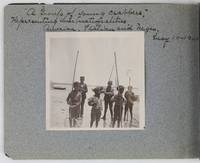
19012885Various locations in Florida 1901. About very good. 16 leaves illustrated with thirty-two original vernacular photographs all 3.5 x 3.5 inches most with manuscript captions in ink above the images. Oblong octavo. Contemporary gray paper wrappers white titles on front cover. Spine mostly split a few shallow chips to edges. Internally clean. A small but important vernacular photograph album containing rare views of the devastation wrought by the Great Fire of 1901 in Jacksonville Florida which took place on May 3 1901. The most destructive event in the history of Jacksonville the Great Fire swept through 146 city blocks destroying over 2000 buildings killing seven people and leaving almost 10000 residents without homes. It is considered the third-largest urban fire in United States history after the Great Chicago Fire and the 1906 San Francisco conflagration.<br /> <br /> The photographs in the present album were taken by an unidentified passenger aboard the Clyde Line steamer Comanche. Eight of the images capture the scene in devastated Jacksonville including a shot of the ruins of the Windsor and St. James hotels shots from atop the "Jacksonville Government Building" a group picture of the city guard "ruins of Jacksonville Court House" "An unknown ruin" a crowded scene at the Jacksonville wharf and a distant shot showing "Ruins of Jacksonville taken from Steamer Comanche May 12." All of the photographs of Jacksonville are dated in manuscript on May 12 1901 nine days after the Great Fire.<br /> <br /> In addition to the Jacksonville pictures other identified locations along the photographer's voyage include the Hillsborough River near Tampa the Tampa Court House scenes around the Tampa Bay Hotel family pictures in Florida the Comanche and its crew Fort Sumter and four views around Charleston. One particularly notable photograph shows six boys standing in shallow water holding fishing nets likely near Tampa. The image is captioned "A group of young crabbers representing three nationalities American Italian and Negro May 10 1901. unknown
191940705Washington D.C.: Published by the United States Coast and Geodetic Survey 1919. Large folding nautical chart printed on heavy paper stock. Colored. A rare coastal survey of the Florida Keys including Newfound Harbor Key Ramrod Key Summerland Key Cudjoe Key Sugarloaf Key Saddlebunch Keys and Big Coppitt Key.<br/> <br/> Established by President Thomas Jefferson in 1807 as the Survey of the Coast the U.S. Coast and Geodetic Survey was the United States' first civilian scientific agency. This agency has followed its mission to survey the U.S. coastline create nautical charts of the coast and help increase maritime safety since its founding and has often played fascinating roles in significant chapters of U.S. history. It served in all theaters of the Civil War in the service of the Union Army and Navy pioneered acoustic exploration in the wake of the sinking of the Titanic and during WWI it worked to detect enemy submarines. In addition this agency worked to survey and produce detailed maps and renderings of the U.S. coast. These nautical survey maps commonly referred to as "T-sheets" provide fascinating insights into the history of the United States coastline which has and will continue to shift. These maps are the most important data source for understanding the physical and ecological characteristics of the U.S. shoreline. The present map is a highly detailed and accurate sea chart of Florida Keys and an important historical view of a developing Florida. Published by the United States Coast and Geodetic Survey unknown
191540709Washington D.C.: Published by the United States Coast and Geodetic Survey 1915. Large folding nautical chart printed on heavy paper stock. Colored. Coastal survey map encompassing Tampa Bay up to Cape San Blas including St. Petersburg Tampa Clearwater St. George Island and Cedar Keys.<br/> <br/> Established by President Thomas Jefferson in 1807 as the Survey of the Coast the U.S. Coast and Geodetic Survey was the United States' first civilian scientific agency. This agency has followed its mission to survey the U.S. coastline create nautical charts of the coast and help increase maritime safety since its founding and has often played fascinating roles in significant chapters of U.S. history. It served in all theaters of the Civil War in the service of the Union Army and Navy pioneered acoustic exploration in the wake of the sinking of the Titanic and during WWI it worked to detect enemy submarines. In addition this agency worked to survey and produce detailed maps and renderings of the U.S. coast. These nautical survey maps commonly referred to as "T-sheets" provide fascinating insights into the history of the United States coastline which has and will continue to shift. These maps are the most important data source for understanding the physical and ecological characteristics of the U.S. shoreline. The present map is a highly detailed and accurate sea chart of the coast of Florida from Tampa Bay to Cape San Blas and is an important historical view of the developing state. Published by the United States Coast and Geodetic Survey unknown
1882345842Braidentown Florida: Published by the author 1882. Second edition. Presentation copy inscribed by the author on the upper part of the front coverr. Frontispiece and illustrations. 83pp. 12mo. Original printed wrappers staining minor wear. Provenance: Thomas W. Streeter booklabel. Second edition. Presentation copy inscribed by the author on the upper part of the front coverr. Frontispiece and illustrations. 83pp. 12mo. "This is an early piece on the beginnings of settlement on the west coast of Florida below Tampa. The tract says that the railroad from Palatka on the St. John's River should be completed "within two years" and that "a narrow-gauge railroad from Tampa to the Manatee and thence to Sarasota Bay will soon follow" Streeter. The portrait is of "Madam Julia Atzeroth The Lady who raised the first coffee grown in the United States." Clark New South I:231; Streeter 1264 this copy Published by the author unknown
191740688Washington D.C.: Published by the United States Coast and Geodetic Survey 1917. Nautical chart printed on heavy paper stock. Colored. A rare coastal survey of the coast from Tampa to Venice including Sarasota Bradenton Longboat Key and Siesta Key.<br/> <br/> Established by President Thomas Jefferson in 1807 as the Survey of the Coast the U.S. Coast and Geodetic Survey was the United States' first civilian scientific agency. This agency has followed its mission to survey the U.S. coastline create nautical charts of the coast and help increase maritime safety since its founding and has often played fascinating roles in significant chapters of U.S. history. It served in all theaters of the Civil War in the service of the Union Army and Navy pioneered acoustic exploration in the wake of the sinking of the Titanic and during WWI it worked to detect enemy submarines. In addition this agency worked to survey and produce detailed maps and renderings of the U.S. coast. These nautical survey maps commonly referred to as "T-sheets" provide fascinating insights into the history of the United States coastline which has and will continue to shift. These maps are the most important data source for understanding the physical and ecological characteristics of the U.S. shoreline. The present map is a highly detailed and accurate sea chart of the coast south of Tampa and an important historical view of a developing Florida. Published by the United States Coast and Geodetic Survey unknown
191640722Washington D.C.: Published by the United States Coast and Geodetic Survey 1916. Large folding nautical chart printed on heavy paper stock. Uncolored. A rare original coastal survey of the central Florida coast around Cedar Keys.<br/> <br/> Established by President Thomas Jefferson in 1807 as the Survey of the Coast the U.S. Coast and Geodetic Survey was the United States' first civilian scientific agency. This agency has followed its mission to survey the U.S. coastline create nautical charts of the coast and help increase maritime safety since its founding and has often played fascinating roles in significant chapters of U.S. history. It served in all theaters of the Civil War in the service of the Union Army and Navy pioneered acoustic exploration in the wake of the sinking of the Titanic and during WWI it worked to detect enemy submarines. In addition this agency worked to survey and produce detailed maps and renderings of the U.S. coast. These nautical survey maps commonly referred to as "T-sheets" provide fascinating insights into the history of the United States coastline which has and will continue to shift. These maps are the most important data source for understanding the physical and ecological characteristics of the U.S. shoreline. The present map of the Florida coastline precedes the inclusion of Yankeetown; chartered in 1923 and the site of one of only two completed sections of the proposed Cross Florida Barge Canal. This map is a highly detailed and accurate sea chart of the central Florida coastal region and an important historical view of a developing Florida. Published by the United States Coast and Geodetic Survey unknown
1960230921960. Cuban Refugees Caravan of Sorrow Miami Herald press photograph archive 1960 to 1966 documents Cuban exile political organizing refugee displacement and United States federal response in South Florida across the critical period between the Cuban Revolution and the Cuban Adjustment Act of 1966. The archive follows a defined sequence of events beginning with the September 1960 Caravan of Sorrow protest a demonstration organized by Cuban exile women traveling from Miami to New York to confront Fidel Castro's appearance at the United Nations and continues through the January 5 1961 closure of the Cuban consulate in Miami following the United States' severance of diplomatic relations on January 3. Subsequent photographs document the Kennedy administration's February 1961 Cuban Refugee Assistance Program centered at Miami's Freedom Tower the March 10-12 1962 Bayfront Park hunger strike in which 152 Cuban exiles demanded arms rather than humanitarian aid the October 1965 Key West arrivals during the Camarioca boatlift initiated on October 10 and the beginning of the federally organized Freedom Flights on December 1 1965. Produced by Miami Herald staff photographers Albert Coya and John Pineda both active documentarians of the Cuban exile community the archive establishes a continuous visual record of exile political life and federal refugee policy during the early Cold War.<br /> <br /> Archive of 12 Large silver gelatin press photographs Miami Herald South Florida 1960 to 1966 Each 10 x 8 inches to 9 x 7 inches with original verso annotations including dates photographer credits editorial markings crop notations and attached newspaper clippings consistent with Miami Herald press photo processing practices. Verso credits identify Albert Coya and John Pineda as staff photographers. Documented subjects include the Caravan of Sorrow bus and assembled Cuban women protesters; the January 5 1961 Cuban consulate closure; refugee intake and processing operations; the Bayfront Park hunger strike accompanied by a clipped headline reading "Exiles Seek Arms Not Aid; 152 Hunger Strikers Freed" dated March 14 1962; police arrests of demonstrators; October 1965 Key West refugee arrivals; and anti-Castro protests. Two photographs dated March 14 1962 document Cuban exiles being forcibly removed by police including one image in which a protester is carried by multiple officers and another showing an individual being thrown into a police van by armed officers providing direct visual evidence of state enforcement against exile demonstrators. One photograph depicts Costa Rican diplomat Gonzalo Facio addressing or attending a Cuban exile rally in April 1964 situating the archive within a broader hemispheric diplomatic context. Additional images show a speaker addressing a large crowd police escorting a detained protester Cuban women aboard a vessel and interior scenes of stacked materials in a processing facility including a sign reading "Se Prohiben Terminantemente." Verso notations such as "Cuban Prisoners Released 1962" "Cuban Refugees" "Anti-Castro Demonstration" and "Cuban Consulate" reflect contemporaneous editorial classification.<br /> <br /> The six-year span of the archive crosses three presidential administrations and documents multiple defining events in Cuban American history through photographs produced on assignment at the moment of occurrence. The Caravan of Sorrow images carry particular research value given later declassification of United States involvement through the Cuban Revolutionary Council placing these photographs among the few contemporaneous visual records outside government archives. The March 1962 Bayfront Park hunger strike occurring after the Bay of Pigs prisoner negotiations and before the Cuban Missile Crisis is documented with attached newspaper evidence confirming both the number of participants and their political demands providing direct insight into divisions within the exile community over United States policy. Light handling wear edge silvering and areas of foxing are present across prints; verso clippings show toning and occasional edge loss consistent with newsroom use. Overall good to very good condition. A cohesive photographer-attributed press archive documenting the development of Cuban exile political identity and United States refugee policy in South Florida during the formative early Cold War period. unknown
1822WRCAM36603Pensacola Fl 1822. 4pp. Folio newspaper. Contemporary annotation above title on p.1 partially trimmed. Split at fold 8-inch tape repair on p.3. A few small holes in text affecting a few letters. A few closed tears in outer margins not affecting text. Age-toned some foxing. A good copy. The thirty-fourth issue of the second newspaper published in Territorial Florida preceded only by the FLORIDA GAZETTE of St. Augustine which began publication in July 1821. Pensacola became a permanent part of the United States under the terms of the Adams-Onìs Treaty of 1819. This issue includes news concerning the United States Congress the Army local shipping pirates and the author of the Waverly novels Walter Scott. There are also advertisements for local businesses professional services including translating and interpreters dry goods furniture and a national lottery. The ad for the Pensacola Book Store includes a list of some seventy titles. A rare early Florida imprint. SERVIES 1076. unknown books
1822WRCAM36604Pensacola Fl 1822. 4pp. Folio newspaper. Contemporary annotation above title on p.1. Split at fold. Lower inner margin pp.3-4 closely trimmed affecting a few letters. A few closed tears in outer margins not affecting text. Age- toned some foxing. A good copy. The thirty-seventh issue of the second newspaper published in Territorial Florida preceded only by the FLORIDA GAZETTE of St. Augustine which began publication in July 1821. Pensacola became a permanent part of the United States under the terms of the Adams-Onìs Treaty of 1819. This issue reports news from the United States Congress including a report from the Secretary of War "devised and pursued for the Civilization of Indian Tribes within the United States." Other articles cover a variety of subjects such as crop rotation the mocking bird and a letter George Washington wrote to the Emperor of Morocco concerning the captivity of mariners. There are also advertisements for local businesses professional services dry goods furniture and a bakery as well as ads for the Pensacola Book Store and the Pensacola Reading Room. A rare early Florida imprint. SERVIES 1076. unknown books
191540691Washington D.C.: Published by the United States Coast and Geodetic Survey 1915. Large folding nautical chat printed on heavy paper stock. Colored. A rare coastal survey of Cape Canaveral including the Kennedy Space Center Cocoa Beach Merritt Island and Satellite Beach.<br/> <br/> Established by President Thomas Jefferson in 1807 as the Survey of the Coast the U.S. Coast and Geodetic Survey was the United States' first civilian scientific agency. This agency has followed its mission to survey the U.S. coastline create nautical charts of the coast and help increase maritime safety since its founding and has often played fascinating roles in significant chapters of U.S. history. It served in all theaters of the Civil War in the service of the Union Army and Navy pioneered acoustic exploration in the wake of the sinking of the Titanic and during WWI it worked to detect enemy submarines. In addition this agency worked to survey and produce detailed maps and renderings of the U.S. coast. These nautical survey maps commonly referred to as "T-sheets" provide fascinating insights into the history of the United States coastline which has and will continue to shift. These maps are the most important data source for understanding the physical and ecological characteristics of the U.S. shoreline. The present map is a highly detailed and accurate sea chart of Cape Canaveral and an important historical view of a developing Florida. Published by the United States Coast and Geodetic Survey unknown
191640723Washington D.C.: Published by the United States Coast and Geodetic Survey 1916. Large folding nautical chart printed on heavy paper stock. Uncolored. A rare original coastal survey of the Cedar Keys and west-central coastline of Florida including Steinhatchee.<br/> <br/> Established by President Thomas Jefferson in 1807 as the Survey of the Coast the U.S. Coast and Geodetic Survey was the United States' first civilian scientific agency. This agency has followed its mission to survey the U.S. coastline create nautical charts of the coast and help increase maritime safety since its founding and has often played fascinating roles in significant chapters of U.S. history. It served in all theaters of the Civil War in the service of the Union Army and Navy pioneered acoustic exploration in the wake of the sinking of the Titanic and during WWI it worked to detect enemy submarines. In addition this agency worked to survey and produce detailed maps and renderings of the U.S. coast. These nautical survey maps commonly referred to as "T-sheets" provide fascinating insights into the history of the United States coastline which has and will continue to shift. These maps are the most important data source for understanding the physical and ecological characteristics of the U.S. shoreline. The present map is a highly detailed and accurate sea chart of the Cedar Keys region and an important historical view of a developing Florida. Published by the United States Coast and Geodetic Survey unknown
191640704Washington D.C.: Published by the United States Coast and Geodetic Survey 1916. Nautical chart printed on heavy paper stock. Colored. A rare coastal survey of the border of Georgia and Florida including Cumberland Island Fernandina and Amelia Island.<br/> <br/> Established by President Thomas Jefferson in 1807 as the Survey of the Coast the U.S. Coast and Geodetic Survey was the United States' first civilian scientific agency. This agency has followed its mission to survey the U.S. coastline create nautical charts of the coast and help increase maritime safety since its founding and has often played fascinating roles in significant chapters of U.S. history. It served in all theaters of the Civil War in the service of the Union Army and Navy pioneered acoustic exploration in the wake of the sinking of the Titanic and during WWI it worked to detect enemy submarines. In addition this agency worked to survey and produce detailed maps and renderings of the U.S. coast. These nautical survey maps commonly referred to as "T-sheets" provide fascinating insights into the history of the United States coastline which has and will continue to shift. These maps are the most important data source for understanding the physical and ecological characteristics of the U.S. shoreline. The present map is a highly detailed and accurate sea chart of the Fernandina area and an important historical view of a developing Florida. Published by the United States Coast and Geodetic Survey unknown
192040683Washington D.C.: Published by the United States Coast and Geodetic Survey 1920. Nautical chart printed on heavy paper stock. Colored. A rare coastal survey of Pensacola Bay including Pensacola and Santa Rosa Island.<br/> <br/> Established by President Thomas Jefferson in 1807 as the Survey of the Coast the U.S. Coast and Geodetic Survey was the United States' first civilian scientific agency. This agency has followed its mission to survey the U.S. coastline create nautical charts of the coast and help increase maritime safety since its founding and has often played fascinating roles in significant chapters of U.S. history. It served in all theaters of the Civil War in the service of the Union Army and Navy pioneered acoustic exploration in the wake of the sinking of the Titanic and during WWI it worked to detect enemy submarines. In addition this agency worked to survey and produce detailed maps and renderings of the U.S. coast. These nautical survey maps commonly referred to as "T-sheets" provide fascinating insights into the history of the United States coastline which has and will continue to shift. These maps are the most important data source for understanding the physical and ecological characteristics of the U.S. shoreline. The present map is a highly detailed and accurate sea chart of the Pensacola Bay and an important historical view of a developing Florida. Published by the United States Coast and Geodetic Survey unknown
191640684Washington D.C.: Published by the United States Coast and Geodetic Survey 1916. Nautical chart printed on heavy paper stock. Colored. A rare coastal survey of Florida from Venice Beach to Fort Myers including Cape Coral Boca Grande and Port Charlotte.<br/> <br/> Established by President Thomas Jefferson in 1807 as the Survey of the Coast the U.S. Coast and Geodetic Survey was the United States' first civilian scientific agency. This agency has followed its mission to survey the U.S. coastline create nautical charts of the coast and help increase maritime safety since its founding and has often played fascinating roles in significant chapters of U.S. history. It served in all theaters of the Civil War in the service of the Union Army and Navy pioneered acoustic exploration in the wake of the sinking of the Titanic and during WWI it worked to detect enemy submarines. In addition this agency worked to survey and produce detailed maps and renderings of the U.S. coast. These nautical survey maps commonly referred to as "T-sheets" provide fascinating insights into the history of the United States coastline which has and will continue to shift. These maps are the most important data source for understanding the physical and ecological characteristics of the U.S. shoreline. The present map is a highly detailed and accurate sea chart of the Fort Myers area and an important historical view of a developing Florida. Published by the United States Coast and Geodetic Survey unknown
191840725Washington D.C.: Published by the United States Coast and Geodetic Survey 1918. Large folding nautical chart printed on heavy paper stock. Colored. A rare original coastal survey of the far Lower Keys region including Marquesas Keys and Boca Grande Key.<br/> <br/> Established by President Thomas Jefferson in 1807 as the Survey of the Coast the U.S. Coast and Geodetic Survey was the United States' first civilian scientific agency. This agency has followed its mission to survey the U.S. coastline create nautical charts of the coast and help increase maritime safety since its founding and has often played fascinating roles in significant chapters of U.S. history. It served in all theaters of the Civil War in the service of the Union Army and Navy pioneered acoustic exploration in the wake of the sinking of the Titanic and during WWI it worked to detect enemy submarines. In addition this agency worked to survey and produce detailed maps and renderings of the U.S. coast. These nautical survey maps commonly referred to as "T-sheets" provide fascinating insights into the history of the United States coastline which has and will continue to shift. These maps are the most important data source for understanding the physical and ecological characteristics of the U.S. shoreline. The present map is a highly detailed and accurate sea chart of the Lower Keys region and an important historical view of a developing Florida. Published by the United States Coast and Geodetic Survey unknown
192040702Washington D.C.: Published by the United States Coast and Geodetic Survey 1920. Large folding nautical chart printed on heavy paper stock. Colored with minor wear. A rare coastal survey of Florida around St. Augustine including Vilano Beach St. Augustine Beach Butler Beach Crescent Beach Palm Coast and Ormond Beach.<br/> <br/> Established by President Thomas Jefferson in 1807 as the Survey of the Coast the U.S. Coast and Geodetic Survey was the United States' first civilian scientific agency. This agency has followed its mission to survey the U.S. coastline create nautical charts of the coast and help increase maritime safety since its founding and has often played fascinating roles in significant chapters of U.S. history. It served in all theaters of the Civil War in the service of the Union Army and Navy pioneered acoustic exploration in the wake of the sinking of the Titanic and during WWI it worked to detect enemy submarines. In addition this agency worked to survey and produce detailed maps and renderings of the U.S. coast. These nautical survey maps commonly referred to as "T-sheets" provide fascinating insights into the history of the United States coastline which has and will continue to shift. These maps are the most important data source for understanding the physical and ecological characteristics of the U.S. shoreline. The present map is a highly detailed and accurate sea chart of St. Augustine area and an important historical view of a developing Florida. Published by the United States Coast and Geodetic Survey unknown
191640716Washington D.C.: Published by the United States Coast and Geodetic Survey 1916. Large folding nautical chart printed on heavy paper stock. Uncolored. A rare original coastal survey of the St. Johns River from Jacksonville to Fleming Island.<br/> <br/> Established by President Thomas Jefferson in 1807 as the Survey of the Coast the U.S. Coast and Geodetic Survey was the United States' first civilian scientific agency. This agency has followed its mission to survey the U.S. coastline create nautical charts of the coast and help increase maritime safety since its founding and has often played fascinating roles in significant chapters of U.S. history. It served in all theaters of the Civil War in the service of the Union Army and Navy pioneered acoustic exploration in the wake of the sinking of the Titanic and during WWI it worked to detect enemy submarines. In addition this agency worked to survey and produce detailed maps and renderings of the U.S. coast. These nautical survey maps commonly referred to as "T-sheets" provide fascinating insights into the history of the United States coastline which has and will continue to shift. These maps are the most important data source for understanding the physical and ecological characteristics of the U.S. shoreline. The present map is a highly detailed and accurate sea chart of St. Johns River around Jacksonville and an important historical view of a developing Florida. Published by the United States Coast and Geodetic Survey unknown
192140694Washington D.C.: Published by the United States Coast and Geodetic Survey 1921. Nautical chart printed on heavy paper stock. Colored. A rare coastal survey of Florida including Laguna beach Panama City Mexico Beach and Cape San Blas.<br/> <br/> Established by President Thomas Jefferson in 1807 as the Survey of the Coast the U.S. Coast and Geodetic Survey was the United States' first civilian scientific agency. This agency has followed its mission to survey the U.S. coastline create nautical charts of the coast and help increase maritime safety since its founding and has often played fascinating roles in significant chapters of U.S. history. It served in all theaters of the Civil War in the service of the Union Army and Navy pioneered acoustic exploration in the wake of the sinking of the Titanic and during WWI it worked to detect enemy submarines. In addition this agency worked to survey and produce detailed maps and renderings of the U.S. coast. These nautical survey maps commonly referred to as "T-sheets" provide fascinating insights into the history of the United States coastline which has and will continue to shift. These maps are the most important data source for understanding the physical and ecological characteristics of the U.S. shoreline. The present map is a highly detailed and accurate sea chart of BLANK and an important historical view of a developing Florida. Published by the United States Coast and Geodetic Survey unknown