[Florida]Biblio.com

364 résultats
191640704Washington D.C.: Published by the United States Coast and Geodetic Survey 1916. Nautical chart printed on heavy paper stock. Colored. A rare coastal survey of the border of Georgia and Florida including Cumberland Island Fernandina and Amelia Island.<br/> <br/> Established by President Thomas Jefferson in 1807 as the Survey of the Coast the U.S. Coast and Geodetic Survey was the United States' first civilian scientific agency. This agency has followed its mission to survey the U.S. coastline create nautical charts of the coast and help increase maritime safety since its founding and has often played fascinating roles in significant chapters of U.S. history. It served in all theaters of the Civil War in the service of the Union Army and Navy pioneered acoustic exploration in the wake of the sinking of the Titanic and during WWI it worked to detect enemy submarines. In addition this agency worked to survey and produce detailed maps and renderings of the U.S. coast. These nautical survey maps commonly referred to as "T-sheets" provide fascinating insights into the history of the United States coastline which has and will continue to shift. These maps are the most important data source for understanding the physical and ecological characteristics of the U.S. shoreline. The present map is a highly detailed and accurate sea chart of the Fernandina area and an important historical view of a developing Florida. Published by the United States Coast and Geodetic Survey unknown
19991320291PN. New. 1999. Soft Cover. Date is original print. This is a reprint edition . PN paperback
1991246788PN. New. 1991. Soft Cover. Date is original print. This is a reprint edition . PN paperback
1938ZB311479Tallahassee: 1938-1944. 7 items bound as 1; sizes vary from small octavo to quarto each 40 to 87 pages and mostly tabular; ex library in one later cloth binding with softcover reatined good. - If you are reading this this item is actually physically in our stock and ready for shipment once ordered. We are not bookjackers. Buyer is responsible for any additional duties taxes or fees required by recipient's country. Photos available upon request. Tallahassee: paperback
1931164984Das Land des Überflusses. Berlin, Oestergaard, 1931. Mit farbigem Titelbild, zahlreichen fotografischen Tafelabbildungen u. Illustrationen von R. H. Francé. 239 S. Or.-Lwd.; Rücken u. Teile der Deckel verblasst. [4 Warenabbildungen]
19853073Minneapolis, Minnesota: Woodbury Press, 1985. o. A. Seiten , 30 cm, Pappeinband mit Schutzumschlag
199142245München, Berlin, Verlag C.J. Bucher GmbH, 1991. 56 Seiten , 30 cm, kartoniert
193120643Berlin-Schöneberg [Innsbrucker Str. 16] : P. J. Oestergaard 1931. 239 S. ; 8°, Schrift: Antiqua gebundene Ausgabe, Halbleder, Einband lichtschattig, sonst Exemplar in gutem Erhaltungszustand
198555389München : Prestel Verlag 1985. 454 S. : 15 farb. Taf., 2 farb. Falttaf., 9 Ktn; 19 cm, mit Schutzumschlag Gewebe, gebundene Ausgabe, Leinen, Exemplar in gutem Erhaltungszustand
194513029scsTallahassee: Florida State Centennial Commission 1945. First Edition. Octavo black cloth hardcover gilt letters and decoration to upper cover fold-out map xi 481 pp. Upper hinge starting; otherwise a Fine copy in a Very Good dust jacket with sunned spine and edgewear that includes light chipping. From Preface: Florida Becomes a State consists of selected documents relating to the admission of Florida to the Union an introduction by Dorothy Dodd Archivist in the Florida State Library and a foreword by W. T. Cash State Librarian discussing social life in Florida bout the time it became a state. The documents consitute a casebook in the formation of a state and are therefore not only useful to those interested in Florida history but to students of the science of government as well. The introduction is a more than skillmul interpretations of the documents; it is a splendid illustration of the gradual progress of Florida in surmounting obstacles on the road to statehood. Florida State Centennial Commission, 1945. First Edition. hardcover
1986Q-0939944448Seaside Pub 1986-01-01. Hardcover. New. In shrink wrap. Looks like an interesting title! Seaside Pub hardcover
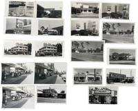
1950233171950. American postwar economic growth and tourism throughout Clearwater Florida photographed by local photographer George Fulmer showing how the Sunbelt expansion operated through roadside motels downtown retail waterfront leisure automobile traffic and service businesses during the rapid growth of the 1950s. The photographs center on the commercial circulation that made Clearwater function as a visitor city spanning rate signage pitched to seasonal travelers motel courts arranged for car access beach parking filled with mid-century automobiles storefront streets where shoppers and pedestrians occupy the sidewalk and crowded dock scenes tied to marine recreation. Clearwater had developed as a resort community by the 1890s and local historical sources note that by 1957 it was known as the fastest growing city in America making this group a concentrated record of the urban and commercial expansion that turned Pinellas County's Gulf Coast into a major tourism economy. <br /> <br /> Photo archive of 72 items including 38 silver gelatin photographs and 34 negatives ranging from 3" x 4" to 4" x 5" contained in 10 photo studio envelopes. Most negatives are duplicates of the print photographs while some are unique images. Clearwater Florida c. 1950s. Repeated and variant views show commercial properties and tourist infrastructure from multiple angles including motels with bold seasonal signage reading "SUMMER RATES $5.00 PER COUPLE FROM APRIL 15 TO NOV. 15" "20 ROOMS $4.00 DOUBLE Apr. 1st-Dec. 1" and "REASONABLE RATES 4 UNITS $5.00 DOUBLE APRIS-JUN." Several prints and negatives picture motel exteriors room interiors with twin beds and lamps a modernist multi-story lodging property with projecting sign and glass-fronted office and a low roadside restaurant or motel building beneath a large fish sign. Other images move into the wider tourist economy: downtown street scenes with McCrory's and Maas Brothers Television signage a storefront reading "Clearwater's American Casuals" a Parsons Paint Co. facade a Brookside Service Travel Gas station advertising regular gasoline at 26 cents and waterfront scenes with rows of parked cars palm-lined drives crowded piers and a dock packed with men women and children waiting or disembarking. The negatives preserve the same emphasis on repeated commercial views indicating studio production for advertising promotional or business use; the group also retains photo studio envelopes inscribed by George Fulmer.<br /> <br /> These photographs place Clearwater within the broader postwar reordering of Florida's Gulf Coast where automobile ownership road travel beach recreation and commercial real estate development produced the built environment commonly identified with Sunbelt growth. Fulmer's images are strongest where they show the interdependence of businesses rather than isolated structures: lodging needed seasonal pricing and motor access downtown retail depended on pedestrian density and curbside traffic waterfront tourism required parking and dock circulation and roadside services converted through-travel into local spending. Visible edge wear light curling and routine handling marks to some prints and negatives; studio envelopes present. Overall good condition. A substantial visual record of how Clearwater's postwar visitor economy operated on the ground with concrete evidence of the businesses prices streets interiors and waterfront traffic that made tourism an urban system rather than a backdrop. unknown
199935464Köln Vista-Point-Verl., 1999. 240 S. 21 cm, Broschiert ,
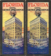
192638235Jacksonville: The Record Company Printers n.d. circa 1926. n.d. circa 1926. 9" x 24" large sheet that folds to twelve 9" x 4" panels including 2 colorful panels. Black and white map entitled: "Hotel George Washington Jacksonville Florida Adams and Julia Streets" shows exactly where the hotel is located. It is the nearest first-class hotel to the Union Terminal the junction of five great railroads. Black and white photographs of the main dining room a typical bedroom the lobby and more. The rates for its 300 bedrooms are: single rooms $3.00 to $5.00 double rooms $5.00 to $8.00. Describes the main hotel office with telephones telegraphs newsstand taxi-cab office et.al.; Barber Shop Book and Gift Shop and a Drug Store. "The Hotel George Washington is the only Hotel in the South with Radio in every room the equipment being equalled only by the largest hotels in the country." Light wear to the extremities and to spine approximate 5" split to one of the folds else a good copy. The Record Company Printers, n.d. (circa 1926). unknown
192140692Washington D.C.: Published by the United States Coast and Geodetic Survey 1921. Nautical chart printed on heavy paper stock. Colored. A rare coastal survey of the Florida Keys including Key Largo Islamorada Long Key Marathon Key and Everglades National Park.<br/> <br/> Established by President Thomas Jefferson in 1807 as the Survey of the Coast the U.S. Coast and Geodetic Survey was the United States' first civilian scientific agency. This agency has followed its mission to survey the U.S. coastline create nautical charts of the coast and help increase maritime safety since its founding and has often played fascinating roles in significant chapters of U.S. history. It served in all theaters of the Civil War in the service of the Union Army and Navy pioneered acoustic exploration in the wake of the sinking of the Titanic and during WWI it worked to detect enemy submarines. In addition this agency worked to survey and produce detailed maps and renderings of the U.S. coast. These nautical survey maps commonly referred to as "T-sheets" provide fascinating insights into the history of the United States coastline which has and will continue to shift. These maps are the most important data source for understanding the physical and ecological characteristics of the U.S. shoreline. The present map is a highly detailed and accurate sea chart of BLANK and an important historical view of a developing Florida. Published by the United States Coast and Geodetic Survey unknown
19610904240097Peninsular Publishing Company 1961-01-01. Paperback. Very Good. Nice looking book has minor edge wear. [Peninsular Publishing Company] paperback
198923986München Polyglott-Verl., 1989. 63 S. 20 cm, Broschiert
19127765Florida Railroad Commission 1912. Hardcover. Good. Burgundy hardcover library binding glit lettering to spine. Light rubbing and shelfwear to covers. Ex-library withdrawn from the Federal Power Commission library with usual stamping etc. Contents clean and tight but page edges tanning with age. Title page has area where sticker was removed. Some light foxing to page edges text block clean. 199 pages index b&w photos. Florida Railroad Commission hardcover
191940705Washington D.C.: Published by the United States Coast and Geodetic Survey 1919. Large folding nautical chart printed on heavy paper stock. Colored. A rare coastal survey of the Florida Keys including Newfound Harbor Key Ramrod Key Summerland Key Cudjoe Key Sugarloaf Key Saddlebunch Keys and Big Coppitt Key.<br/> <br/> Established by President Thomas Jefferson in 1807 as the Survey of the Coast the U.S. Coast and Geodetic Survey was the United States' first civilian scientific agency. This agency has followed its mission to survey the U.S. coastline create nautical charts of the coast and help increase maritime safety since its founding and has often played fascinating roles in significant chapters of U.S. history. It served in all theaters of the Civil War in the service of the Union Army and Navy pioneered acoustic exploration in the wake of the sinking of the Titanic and during WWI it worked to detect enemy submarines. In addition this agency worked to survey and produce detailed maps and renderings of the U.S. coast. These nautical survey maps commonly referred to as "T-sheets" provide fascinating insights into the history of the United States coastline which has and will continue to shift. These maps are the most important data source for understanding the physical and ecological characteristics of the U.S. shoreline. The present map is a highly detailed and accurate sea chart of Florida Keys and an important historical view of a developing Florida. Published by the United States Coast and Geodetic Survey unknown
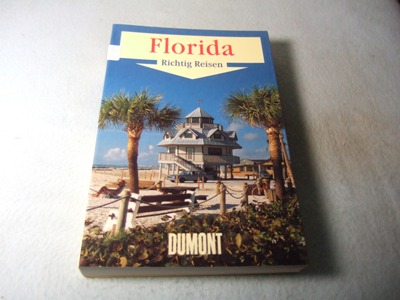
1997200077DuMont, 1997. 320 Seiten mit zahlreichen Farbfotos und Karten Softcover/Paperback
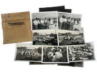
1951229201951. Jim Crow Florida Segregated public facility photograph archive from Clearwater Florida by George Fulmer 1951. Collection consists of 14 photographs including 7 black-and-white photographs and 7 associated film negatives documenting African American children in a newly opened library and schoolyard as well as a segregated swimming-pool planning meeting attended by city officials. Produced by George Fulmer Clearwater's longtime municipal photographer and WWII U.S. Navy enlisted photographer these images survive in their original studio proof envelopes from the George Fulmer Estate recovered after the 2014-2015 demolition of the Fulmer Studio which had stood beside the Clearwater Courthouse for over 65 years. The photographs measure 3.5" x 5" and the negatives are on Kodak safety film measuring 4" x 5" each. <br /> <br /> This archive captures two deeply revealing moments in the segregated civic history of mid-century Florida. The first packet labeled and dated to summer 1951 presents five photographs of Black schoolchildren reading playing circle games outdoors and participating in early library programming clear evidence of segregated educational resources but also of Black childhood joy and community-building within constrained circumstances. A white librarian or teacher is visible at the front of the classroom underscoring the racialized hierarchy embedded in Florida's school system prior to Brown v. Board of Education in 1954. The second packet likely taken only weeks apart based on Fulmer's original numbering system documents a group of white and Black men gathered around architectural plans for a segregated municipal swimming pool. The interracial nature of the planning body illuminates the complex often unequal negotiations around public development in Jim Crow Florida where recreational segregation remained legal until at least 1954-1955. These photographs represent an unusual visual record of the bureaucratic process behind segregated facilities.<br /> <br /> As part of the vast body of more than 100000 photographs preserved from Fulmer's studio much of which was claimed by the local historical society this small group represents a scarce surviving fragment of Clearwater's visual civic record with Fulmer's estate retaining a curated exhibition core and only limited dispersal of individual images. Fulmer documented weddings police activities construction projects civic events and wartime subjects but photographs relating to segregated facilities especially of Black children and community spaces are extremely limited in the archive. These images therefore constitute an important resource for researchers of Jim Crow Florida Black educational history municipal segregation and postwar Southern urban development. Photographs and negatives are crisp and clean only expressing minimal edge wear. Original Fulmer Studio proof envelopes present annotated in pencil with job numbers and subjects. Comes with two certificates of authenticity from the Fulmer estate. Overall very good condition. unknown