[Florida & Georgia]Biblio.com

364 résultats
191940735Washington D.C.: Published by the United States Coast and Geodetic Survey 1919. Large folding nautical chart printed on heavy paper stock. Colored. A rare original coastal survey of Florida and Georgia from Sapelo Island to Amelia Island including St. Simons Island Sea Island Brunswick Jekyll Island Cumberland Island and Fernandina Beach.<br/> <br/> Established by President Thomas Jefferson in 1807 as the Survey of the Coast the U.S. Coast and Geodetic Survey was the United States' first civilian scientific agency. This agency has followed its mission to survey the U.S. coastline create nautical charts of the coast and help increase maritime safety since its founding and has often played fascinating roles in significant chapters of U.S. history. It served in all theaters of the Civil War in the service of the Union Army and Navy pioneered acoustic exploration in the wake of the sinking of the Titanic and during WWI it worked to detect enemy submarines. In addition this agency worked to survey and produce detailed maps and renderings of the U.S. coast. These nautical survey maps commonly referred to as "T-sheets" provide fascinating insights into the history of the United States coastline which has and will continue to shift. These maps are the most important data source for understanding the physical and ecological characteristics of the U.S. shoreline. The present map is a highly detailed and accurate sea chart of the coastal border between Georgia and Florida and an important historical view of the developing states. Published by the United States Coast and Geodetic Survey unknown
191940701Washington D.C.: Published by the United States Coast and Geodetic Survey 1919. Large folding nautical chart printed on heavy paper stock. Colored. A rare coastal survey around Jacksonville including Fernandina Beach Amelia Island Jacksonville Atlantic Beach Neptune Beach Jacksonville Beach Ponte Vedra and Sawgrass.<br/> <br/> Established by President Thomas Jefferson in 1807 as the Survey of the Coast the U.S. Coast and Geodetic Survey was the United States' first civilian scientific agency. This agency has followed its mission to survey the U.S. coastline create nautical charts of the coast and help increase maritime safety since its founding and has often played fascinating roles in significant chapters of U.S. history. It served in all theaters of the Civil War in the service of the Union Army and Navy pioneered acoustic exploration in the wake of the sinking of the Titanic and during WWI it worked to detect enemy submarines. In addition this agency worked to survey and produce detailed maps and renderings of the U.S. coast. These nautical survey maps commonly referred to as "T-sheets" provide fascinating insights into the history of the United States coastline which has and will continue to shift. These maps are the most important data source for understanding the physical and ecological characteristics of the U.S. shoreline. The present map is a highly detailed and accurate sea chart of the coast around Jacksonville and an important historical view of a developing Florida. Published by the United States Coast and Geodetic Survey unknown
1997Q-0965934101Florida Goal-Liners 1997-09-01. Hardcover. New. In shrink wrap. Looks like an interesting title! Florida Goal-Liners hardcover
197831446Walter-Verlag, Olten und Freiburg, 1978. 383 Seiten, 8° , ca. 21 x 13 cm, Leinen mit Schutzumschlag
1997Q-0960661638Favorite Recipes Press FRP 1997. Hardcover. New. In shrink wrap. Looks like an interesting title! Favorite Recipes Press (FRP) hardcover
1963GA001181Ino place: Florida South Chapter AIA. VG/ none. 1963. First edition. Wraps. 64 pages. Cover is loose. . Florida South Chapter AIA paperback
190840737Washington D.C.: Published by the United States Coast and Geodetic Survey 1908. Large folding nautical chart printed on heavy paper stock. Colored. A rare original coastal survey of the Gulf coasts of Florida Alabama Mississippi and Louisiana including the Keys Fort Myers Sarasota Tampa Panama City Destin Pensacola Gulf Shores Mobile Biloxi Gulfport New Orleans and the Mississippi Delta.<br/> <br/> Established by President Thomas Jefferson in 1807 as the Survey of the Coast the U.S. Coast and Geodetic Survey was the United States' first civilian scientific agency. This agency has followed its mission to survey the U.S. coastline create nautical charts of the coast and help increase maritime safety since its founding and has often played fascinating roles in significant chapters of U.S. history. It served in all theaters of the Civil War in the service of the Union Army and Navy pioneered acoustic exploration in the wake of the sinking of the Titanic and during WWI it worked to detect enemy submarines. In addition this agency worked to survey and produce detailed maps and renderings of the U.S. coast. These nautical survey maps commonly referred to as "T-sheets" provide fascinating insights into the history of the United States coastline which has and will continue to shift. These maps are the most important data source for understanding the physical and ecological characteristics of the U.S. shoreline. The present map is a highly detailed and accurate sea chart of the coasts Florida Alabama Mississippi and Louisiana along the Gulf of Mexico and an important historical view of the developing states. Published by the United States Coast and Geodetic Survey unknown
193857192New York: Sheridan House 1938. 8vo. 287 1 pp. Numerous photo plates colour maps on endpapers. Forest-green tweed boards black lettering colour maps on endpapers minor bumping head of spine slight bumping to couple corners w/ d.j. cover art of the Gypsy Waters under sail couple minor closed tears edgewear still VG/VG- copy. First edition of this author’s memoir detailing the rebuilding and outfitting of a Chesapeake Bay Bugeye ketch he renamed Gypsy Waters and the several adventures with his family to the Bahamas the Gulf Islands the Gulf lakes and rivers of Florida and more. Scarce in original dustjacket. Sheridan House, hardcover
191640724Washington D.C.: Published by the United States Coast and Geodetic Survey 1916. Large folding nautical chart printed on heavy paper stock. Colored. A rare original coastal survey of Florida from Tampa Bay to the Keys including Tampa St. Petersburg Sarasota Fort Myers Naples and of Northern Cuba including Havana.<br/> <br/> Established by President Thomas Jefferson in 1807 as the Survey of the Coast the U.S. Coast and Geodetic Survey was the United States' first civilian scientific agency. This agency has followed its mission to survey the U.S. coastline create nautical charts of the coast and help increase maritime safety since its founding and has often played fascinating roles in significant chapters of U.S. history. It served in all theaters of the Civil War in the service of the Union Army and Navy pioneered acoustic exploration in the wake of the sinking of the Titanic and during WWI it worked to detect enemy submarines. In addition this agency worked to survey and produce detailed maps and renderings of the U.S. coast. These nautical survey maps commonly referred to as "T-sheets" provide fascinating insights into the history of the United States coastline which has and will continue to shift. These maps are the most important data source for understanding the physical and ecological characteristics of the U.S. shoreline. The present map is a highly detailed and accurate sea chart of the Greater Florida Gulf region and an important historical view of a developing Florida. Published by the United States Coast and Geodetic Survey unknown
191640703Washington D.C.: Published by the United States Coast and Geodetic Survey 1916. Large folding nautical chart printed on heavy paper stock. Colored with minor wear. A rare coastal survey of Florida around Daytona including Ormond Beach Daytona Beach Port Orange New Smyrna Beach and Edgewater.<br/> <br/> Established by President Thomas Jefferson in 1807 as the Survey of the Coast the U.S. Coast and Geodetic Survey was the United States' first civilian scientific agency. This agency has followed its mission to survey the U.S. coastline create nautical charts of the coast and help increase maritime safety since its founding and has often played fascinating roles in significant chapters of U.S. history. It served in all theaters of the Civil War in the service of the Union Army and Navy pioneered acoustic exploration in the wake of the sinking of the Titanic and during WWI it worked to detect enemy submarines. In addition this agency worked to survey and produce detailed maps and renderings of the U.S. coast. These nautical survey maps commonly referred to as "T-sheets" provide fascinating insights into the history of the United States coastline which has and will continue to shift. These maps are the most important data source for understanding the physical and ecological characteristics of the U.S. shoreline. The present map is a highly detailed and accurate sea chart of the Daytona area and an important historical view of a developing Florida. Published by the United States Coast and Geodetic Survey unknown
2000Q-0742504328AltaMira Press 2000-05-30. Paperback. New. In shrink wrap. Looks like an interesting title! AltaMira Press paperback
1988ZB394189Florida International University. 1988-1994. volumes 1-2; 6. 1988-1994. partly bound library markings textually clean & tight PRICE IS FOR THE LOT. - If you are reading this this item is actually physically in our stock and ready for shipment once ordered. We are not bookjackers. Buyer is responsible for any additional duties taxes or fees required by recipient's country. Photos available upon request. Florida International University. unknown
19934057CBGainesville/Tallahassee/Tampa [u.a.], University Press of Florida (= The Ripley P. Bullen Series; Columbus Quincentenary Series), 1993. 8°, 292 S. mit s/w-Abbildungen und Karten (Text: Englisch), original Leineneinband mit original Schutzumschlag in einem abnehmbaren Folienbezug, Erstausgabe ordnungsgemäß ausgesondertes Bibliotheksexemplar mit den üblichen Kennzeichen (Folienbezug (abnehmbar!), kleinem Aufkleber unten auf Buchrücken, einem kleinen Stempel unten auf der Vorsatzseite, einem Stempel auf Kopfschnitt und kleiner Tasche für den Au
1956acs1209Gulfport Fla.: Boca Ciega High School 1956-1958. 8 issues including: Volume III No. 10 Feb. 28 1956; Vol. III No. 13 April 10 1956; Vol. III No. 14 April 24 1956; Vol. IV No. 12 April 8 1957; Vol. V No. 8 Jan. 22 1958; Vol. V No. 9 Feb. 14 1958; Vol. V No. 13 April 11 1958; and Vol. V No. 15 May16 1948. Together 8 issues. Boca Ciega High opened in the fall of 1953. These are early issues in fact award-winning issues featuring school news and personalities. Very Good. Boca Ciega High School, 1956-1958. unknown
191940690Washington D.C.: Published by the United States Coast and Geodetic Survey 1919. Nautical chart printed on heavy paper stock. Colored with minor wear. A rare coastal survey of Fort Lauderdale Hollywood Miami and Key Biscayne.<br/> <br/> Established by President Thomas Jefferson in 1807 as the Survey of the Coast the U.S. Coast and Geodetic Survey was the United States' first civilian scientific agency. This agency has followed its mission to survey the U.S. coastline create nautical charts of the coast and help increase maritime safety since its founding and has often played fascinating roles in significant chapters of U.S. history. It served in all theaters of the Civil War in the service of the Union Army and Navy pioneered acoustic exploration in the wake of the sinking of the Titanic and during WWI it worked to detect enemy submarines. In addition this agency worked to survey and produce detailed maps and renderings of the U.S. coast. These nautical survey maps commonly referred to as "T-sheets" provide fascinating insights into the history of the United States coastline which has and will continue to shift. These maps are the most important data source for understanding the physical and ecological characteristics of the U.S. shoreline. The present map is a highly detailed and accurate sea chart of the Miami area and an important historical view of a developing Florida. Published by the United States Coast and Geodetic Survey unknown
199840394MilledgevilleGA: Boyd Publishing Company 1998. First Edition. Hardcover. Fine. 759p octavo a fine copy in burgundy cloth highlighted in yellow on numerous pages in the text. <br/><br/> Boyd Publishing Company hardcover
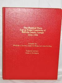
19980022516Milledgeville Ga.: Boyd Publishing Company Inc. 1998. First Edition. . Hardcover. Near Fine/None Issued. NF/0/1st ed. Clean and tight--just the thing if you like to buy your research material by the pound!This hefty volume is in excellent shape; it has some shallow abrasions on the front cover-you have to hold the book up to the light to see them. Gold gilt lettering to front and spine all present. There's a short inscription on the front pastedown"To June and Burl- Merry Christmas '98-- Eugenia and "Sis". Two of the three editors signed the front free endpapers--names only. No writing or marking to this mamoth collection of cemetery records. 759pp. Records broken down into three section according to location in cemetery. Location Maps Cross Reference Listings to Former Lot Owners in the Andrews Directory Index to Military Veterans Revolutiornary to Vietnam Government Official Index Glossary and Abbreviations Index to Every Known Grave. A wonderful example of polished and exact research. I own this book and can have it in the mail tomorrow. <br/> <br/> Boyd Publishing Company, Inc. hardcover
2000mon0000011736Rowman & Littlefield Publishers 10/1/2024 12:00:01 A. hardcover. Very Good. 1.2200 in x 9.3000 in x 6.3300 in. 3rd edition. Hardcover issued without dust-jacket. Clean and solid. Ships from a smoke-free home. Rowman & Littlefield Publishers hardcover
191640718Washington D.C.: Published by the United States Coast and Geodetic Survey 1916. Large folding nautical chart printed on heavy paper stock. Colored. A rare original coastal survey of the coastline north of Tampa including Tarpon Springs Palm Harbor Hudson and Anclote Keys.<br/> <br/> Established by President Thomas Jefferson in 1807 as the Survey of the Coast the U.S. Coast and Geodetic Survey was the United States' first civilian scientific agency. This agency has followed its mission to survey the U.S. coastline create nautical charts of the coast and help increase maritime safety since its founding and has often played fascinating roles in significant chapters of U.S. history. It served in all theaters of the Civil War in the service of the Union Army and Navy pioneered acoustic exploration in the wake of the sinking of the Titanic and during WWI it worked to detect enemy submarines. In addition this agency worked to survey and produce detailed maps and renderings of the U.S. coast. These nautical survey maps commonly referred to as "T-sheets" provide fascinating insights into the history of the United States coastline which has and will continue to shift. These maps are the most important data source for understanding the physical and ecological characteristics of the U.S. shoreline. The present map is a highly detailed and accurate sea chart of the Tampa region and an important historical view of a developing Florida. Published by the United States Coast and Geodetic Survey unknown
196333112Miami Beach 1963. Hotelprospekt im Format 46x30 cm mit mehrfarb. Abb. Lose beiliegend: 4-seit. tariff schedule des Cadillac Hotel Cabana Cub. Faltmaß 23x10 cm.
1986x-0882851136Rutgers Univ Center for Urban 1986. Paperback. New. 9.25x6.25x1.50 inches. Rutgers Univ Center for Urban paperback
1990SONG0880102918Brand: Rudolph Steiner Pr 1990-10-01. paperback. Used: Good. 6.00x0.25x8.75. Buy with confidence. Excellent Customer Service & Return policy. Brand: Rudolph Steiner Pr paperback