Sydney and Louisburg Coal Railway CoBiblio.com
5 209 résultats
033180557X.Ghardcover. Good. Access codes and supplements are not guaranteed with used items. May be an ex-library book. hardcover
1334949026.Gpaperback. Good. Access codes and supplements are not guaranteed with used items. May be an ex-library book. paperback
20152090202120701027Electric Vehicle Research Society Railway Map Publishing Society 2015. Soft Cover. Fine. Number of pages: 455 pages Size: A4 size Electric Vehicle Research Society Railway Map Publishing Society paperback
19972111902160300990local publisher 1997. Soft Cover. Fine. Number of pages: 239 pages Size: A4 size local publisher paperback
19952091502134000273first law 1995. Soft Cover. Fine. Number of books: 1 first law paperback
19492091202133001568Unkyo Publishing Association 1949. Soft Cover. Fine. Number of books: 1 Unkyo Publishing Association paperback
19802090202120809958Rekishi tosho-sha 1980. Soft Cover. Fine. Volume: 1 Rekishi tosho-sha paperback
19522111902153000059Koeisha 1952. Soft Cover. Fine. Size: A5 size Number of books: 1 Koeisha paperback
19782091202133105899Traffic Culture Cooperation Association 1978. Soft Cover. Fine. Volume: 1 Traffic Culture Cooperation Association paperback
0364809760.Ghardcover. Good. Access codes and supplements are not guaranteed with used items. May be an ex-library book. hardcover
20122091502135420912Pukukennori 2012. Soft Cover. Fine. Number of books: 1 Pukukennori paperback
a105543One hardcover tall narrow 4to leather covered record book. 223p. of handwritten entries plus just a few blank pages . Fully ink manuscript easily legible. Itemized list of freights shipped with owner's names and cost of shipping plus receipts for items purchased by the railroad company. Leather cover worn and chipped. Boards cracked at hinges but holding by binding strings. Binding secure. Original leather spine label still present "Ledger" but lightly chipped. Includes several signatures and at least 3 orange tax stamps are tipped in. The Summit Branch RR Company was incorporated in 1851. . hardcover
2111902153102113Nainen Publishing N.A. Soft Cover. Fine. Number of books: 1 Nainen Publishing paperback
0656776811.Ghardcover. Good. Access codes and supplements are not guaranteed with used items. May be an ex-library book. hardcover
0331478579.Ghardcover. Good. Access codes and supplements are not guaranteed with used items. May be an ex-library book. hardcover
0331478552.Gpaperback. Good. Access codes and supplements are not guaranteed with used items. May be an ex-library book. paperback
20181-3337703895hansebooks 2018. Paperback. New. 416 pages. 8.50x5.99x0.94 inches. hansebooks paperback
0267875681.Ghardcover. Good. Access codes and supplements are not guaranteed with used items. May be an ex-library book. hardcover
1333093160.Gpaperback. Good. Access codes and supplements are not guaranteed with used items. May be an ex-library book. paperback
0260041076.Ghardcover. Good. Access codes and supplements are not guaranteed with used items. May be an ex-library book. hardcover
1390945855.Gpaperback. Good. Access codes and supplements are not guaranteed with used items. May be an ex-library book. paperback
1396369392.Ghardcover. Good. Access codes and supplements are not guaranteed with used items. May be an ex-library book. hardcover
1527896447.Gpaperback. Good. Access codes and supplements are not guaranteed with used items. May be an ex-library book. paperback
0484308815.Ghardcover. Good. Access codes and supplements are not guaranteed with used items. May be an ex-library book. hardcover
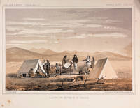
186014426Washington DC: Thomas H. Ford Printer 1860. First Edition. Very Good. 8.25x11in One litho tinted illustrated plate Part I plate XXXII; Some age-toning along edges with several light spots in margin and print. Samuels p.460 Taft p. 1. This plate is from from Volume XII of the quarto edition of twelve volumes were published from 1855 to 1861 as exploration and survey reports became available. These volumes contained not only the survey maps and elevations but a monumental collection of scientific reports on geography geology zoology botany and ethnology of the Native American tribes. The surveys also included 11 artists to record the landscape and indigenous peoples of the west. The twelve volumes were disorganized in publication with no overall all arrangement or indexing. Some of the plates and maps referred to in volumes were published in other volumes various reports were also published out of sequence relating to the four routes. Preliminary reports published were updated in latter volumes. From Wagner-Becker-Camp In 1853 Senator Gwin of California lead the inclusion of Congressional funding for 1853-54 of a series of surveys to determine the best and most economical railroad routes from the Mississippi River to the Pacific coast. The act directed the Secretary of War Jefferson Davis to plan and direct Army topographical engineers to conduct surveys of four routes. The first was between the 47th and 49th parallels generally along the Lewis and Clark route to the Pacific. The Second route between the 37th and 39th parallels was promoted by Senator Thomas Hart Benton of Missouri. The Third route was along the 35th parallel. The Fourth route was promoted by Secretary Davis along the 32nd parallel that followed Emory's 1846-47 reconnaissance.<br /> <br /> The illustration "Awaiting the Return of Mr. Tinkham" was done to support part of the report narrative by Stevens starting on p. 127 of the report. Mr. Tinkham was one of several civilian members of the survey that fanned out along the general route to identify better terrain for a railroad line. They were generally accompanied by Native American guides the knew the terrain. Mr. Tinkham proceed without a guide and became disoriented for a number of days before finding his way back to the camp. <br /> <br /> John Mix Stanley 1814-1872 was an artist-explorer American painter of landscapes and of Native American portraits and tribal life. In 1842 he traveled to the West to paint Native Americans and spend the next ten years painting and exhibiting in eastern cities and the Smithsonian. During the Mexican War in 1846 he was a draftsman for the Corps of Engineers assigned to Colonel Kearney's expedition to California and Oregon Territory. He produced maps and illustrations for the Army. After the war he spent time in Hawaii painting the Royal family native life and landscapes. In 1853 Stanley was appointed the chief artist to Isaac Stevens survey expedition for a Pacific railroad route from St. Paul to Puget Sound the Northern Survey. During the survey he produced the stunning 70 illustrations and fold out panoramas in the Stevens report. When he returned to Washington in 1854 he produced an exhibition of his paintings and large panoramas of western scenes from the Northern survey. from Wiki and Samuels in part. Thomas H. Ford, Printer unknown