Francesco CoreaBiblio.com

2 087 résultats
2017BN833252017. 2017. Softcover. Artificial Intelligence and Exponential Technologies: Business Models Evolution and New Investment Opportunities <br/><br/> paperback
19292091502133904137Not Available 1929. Soft Cover. Fine. Volume: 1 Not Available paperback
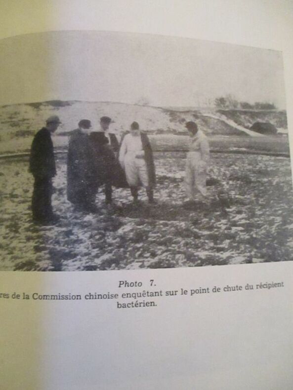
195265131952 Pekin 1952 fort volume In8 659 pages très grandes planches dépliantes et reproductions photographiques dans le texte
2007studyfloraAcademy Publishing Co. 2007 Academy Publishing Co. 2007 large heavy hardback red titles to light green cloth in clear protective jacket XIV 1482 pages text in English. A BRAND NEW BOOK UNUSED. Full refund if not satisfied. 24 hour dispatch via Insured Signed for. If not pictured in this listing a scan of the actual book is available on request. Hardcover. New. Academy Publishing Co. hardcover
19252091502133904181Not Available 1925. Soft Cover. Fine. Volume: 1 Not Available paperback
19922080302106805442Not Available 1992. Soft Cover. Fine. The book is in fine condition. Not Available paperback
97002aaf(Paris, Didot), vers 1748, 29 x 33 cm (32 x 35.5 cm, le papier).
19822091502135413878Research Institute of Ethnic Culture Korea University Publishing Department 1982. Soft Cover. Fine. Number of books: 2 Research Institute of Ethnic Culture, Korea University Publishing Department paperback
19372091502135416819Not Available 1937. Soft Cover. Fine. Number of books: 1 Not Available paperback
19842092902141900101Minzoku en 1984. Soft Cover. Fine. Size: 23cm Number of books: 3 in total Minzoku en paperback
19372083002117300251Korea Gyeongseong Imperial Local Administration Society Korea Headquarters 1937. Soft Cover. Fine. The book is in fine condition. Korea Gyeongseong Imperial Local Administration Society Korea Headquarters paperback
19912091502135420474Korea Institute of Spiritual Culture 1991. Soft Cover. Fine. Number of books: 7 Korea Institute of Spiritual Culture paperback
19392080202103701573Railway Bureau of the Government General of Korea 1939. Soft Cover. Fine. Size: 20cm B6 Railway Bureau of the Government General of Korea paperback
8vo., First Edition, with portrait frontispiece and endpaper maps, some mild offsetting from fold-ins to free endpapers; navy cloth, gilt back, a very good, bright, clean copy in unclipped dustwrapper, the latter chipped at head and tail of backstrip. A PRESENTATION COPY FROM THE AUTHOR WITH HIS SIGNED HOLOGRAPH INSCRIPTION ON TITLE. The epic stand of 1 Glosters on Hill 235 at the eastern crossing of the Imjin River. SIGNED COPIES ARE EXTREMELY SCARCE.
17701606Augsburg, Lotter, 1770. Ritter, Lotter S. 126. - Mit figürlicher Kartusche, Schriftkasten und "Annotatio". - Die dekorative Karte umfasst ganz Asien, einschließlich Ostindien. Japan ist mit dem Festland durch ein Land verbunden, das als Terra Yeco bezeichnet wird (ungefähr die Lage des heutigen Hokkaido). Weiter im Nordwesten befindet sich die fiktive "Terra de la Compagnie", während Korea als Halbinsel dargestellt wird. Ostsibirien, noch unerforscht, fehlt völlig. In der Darstellung Südostasiens nehmen Indochina, Indonesien und die Philippinen allmählich ihre wahren Umrisse an. - Insgesamt wohlerhaltenes Exemplar.
193874971N.p.: South Manchuria Railroad. ca. 1938. This map has no date that we can see but history would likely place it at the end of the 30s. It is a full color and artistic panorama measuring 40 1/2 x 8 inches. The color map is on the recto and the verso is filled with text and illustrations of all the desirable and holy sites that the train's path goes through. The eight panels show the area of Kongosan or the Diamond Mountains. Some soiling to front panel and a recurring 1 inch tear to top border of each panel. Very bright and attractive.In 1910 Japan formally annexed Korea as a colony although in actuality Japan had been ruling Korea in some manner since 1876. The Japanese felt that their growing empire needed a buffer zone between the other two powers in the regions; China and Russia. Manchuria was also rich agricultural land with vast fields of soy. The laying out of a railway is a godd method of establishing borders so the Japanese were quick to lay down tracks. The Diamond Mountain or the Kumgang Mountains are a mountain/mountain range with a 1638-metre-high 5374 ft Birobong peak in Kangwon-do North Korea. It is about 50 kilometres 31 mi from the South Korean city of Sokcho in Gangwon-do. It is one of the best-known mountains in North Korea. The area often called "12000 Peaks" is one of the most revered sites for natural beauty on the Korean penisula. Koreans have perceived Kumgangsan as their muse since well before the Middle Ages. Practically every poet and artist who lived during the Joseon dynasty 1392-1910 made a pilgrimage to Kumgangsan. Among other well-known works are the Geumgang jeondo and the Pungaknaesan chongramdo painted in the 1740s by Jeong Seon. It was an area of religious interest as well and there were as many as 400 monasteries in the area. South Manchuria Railroad. unknown
1985145179Los Angeles: CBS / Universal City Studios 1985. Draft script for the 1986 pilot episode for the television show "Outlaws." <br/><br/>A sheriff and his deputies are transported from the year 1899 into the future by a lightning storm and they establish a new life as private detectives. <br/><br/>Set in Houston in 1899 and 1999. <br/><br/>Gray titled wrappers. Title page present noted as production No. 86084 dated November 26 1985 with credits for screenwriter/executive producer Nicholas Corea. 123 leaves with last page of text numbered 120. Xerographic duplication rectos only. Pages Fine wrapper Fine bound with three gold brads. CBS / Universal City Studios unknown books
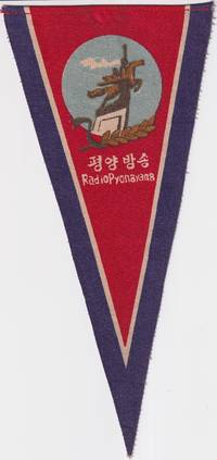
1960219665No publication details. circa1960s –70s based on design and material. Printed fabric pennant promoting Radio Pyongyang North Korea’s official broadcasting service. The image shows a stylised monument of two figures possibly symbolising industry and broadcasting with a laurel motif and radio waves under a red sky. Text in both Korean and English. Radio Pyongyang. “평양 방송” translates directly as Pyongyang Broadcasting. Text in Korean and English. 23.5 height x 11cm at top edge. <br> <br>A scarce example of early North Korean visual propaganda. Radio Pyongyang was founded in October 1945 and inaugurated programming with a live broadcast of Kim Il Sung's victory speech when he returned to Pyongyang at the end of WWII. The image on this pennant features a statue of two figures a worker and a peasant woman carrying a sheaf of rice riding the mythical horse Chollima symbolising speed strength and the spirit of the North Korean people. The Chollima movement which began in 1956 encouraged citizens to achieve extraordinary production and labour targets indicated by the sheaf of wheat symbolic of agricultural abundance. Radio Pyongyang helped to disseminaate the ideals of the Chollima movement and this pennant probably dates from after the Chollima Monument was unveiled in 1961. <br> <br>Provenance: Bought in China by a western collector in the late 20th century. . No publication details. unknown
198237515Seoul: Po Chin Chai 1982. 488 S., 25 Taf. m. z.T. farb. Abb. u. Ill., 82 eingekl. Schriftmuster auf Taf., Lit.verz. 2° HLn.iS. *neuwertig* Widmung des Autors auf Vorsatz eingeklebt*
Carta geografica, antica ed originale, con coloritura coeva ai confini. La mappa edita nella città tedesca di Weimar è stata disegnata nel 1820 e rappresenta il territorio della Cina e della Penisola Coreana. Rara edizione
Ulrico Hoepli, Editore Libraio della Real Casa Milano, 1895. Con 37 silografie nel testo, 2 tavole a colori e la Carta della Corea e del Teatro della Guerra (che non risulta). In 4to piccolo, front. in rosso / nero pp. IX, 278 (con lunga Appendice), leg. orig. in t. percallina azzurra con titoli in bianco. Raro a reperirsi e di grande interesse storico - politico. Legatura con imperfezioni del tempo, interno molto ben conservato. .
22233Charles Delagrave, Paris, 1905
197924493Tokyo, Gakken / Gakushu Kenkyusha, 1978-1979. 3 volumes complete: Vol. 1: Nihon. [Japanese folk arts.]. - Vol. 2: Toyo. [Asian folk arts: mainly from China and Korea.]. - Vol. 3: Obei sonota / O-Bei, sono-ta. [Folk arts of Europe, the Americas and other places.]. - Text in Japanese; captions and essays by Bernard Leach and Hiroshi Mizuo also in English. 230; 228; 229 pages with numerous illustrations (some color). Fol. (38 x 27 cm), Original gray cloth bindings with illustrated original dust jackets in original cloth slipcases with two-tone title lettering in red and silver. [9 Warenabbildungen]
1851200120AG1851. London Edinburgh & Dublin J.& F. Tallis 1851. Original steel engraving / Vintage map. Drawn and engraved by John Rapkin. Partly hand-coloured. Illustrations by H. Warren and Enrgaved by J.H. Kernot. Plate Size: 33 cm x 25.5 cm. Sheet Size: 37.4 cm x 27.3 cm. Vintage 19th century map in very good condition. Published in the Illustrated Atlas And Modern History Of The World Geographical Political Commercial & Statistical Edited By R. Montgomery Martin. Beautifully bordered and fascinating map of Japan and Korea. The names of the major islands of Japan - Kiosiou Sitkokfi Shikoku and Niphon Honshu and the southern tip of 'Matsmai or Yersqi' Hokkaido are included on the map. Below the elbow of Honshu can be seen the tiny island of Fatsisio - the 'place of exile for the Grandees of Japan.' The map's nomenclature is interesting: Tokyo not yet the capital is named as Yedo while the then-capital Kyoto appears as 'Meaco'. Across the Korean Strait modern Seoul appears as 'Han y'. As these maps were being published both of these ancient and distinctive states Korea - the 'Hermit Kingdom' - and Japan - isolated under the centuries' long under the sakoku policy - were having to acclimate to increased Western influence in their region. The 1853-54 U.S. diplomatic and military naval expedition under Commodore Perry would force the establishment of diplomatic relations between Japan and the western "Great Powers" and eventually to the collapse of the ruling Tokugawa shogunate and the Meiji Restoration. Japan would partially embrace the West and western influences and emerge as a burgeoning regional power eventually establishing control over Korea by the early 20th century - at the beginning a calamitous half-century for the region. John Tallis 7 November 1817 3 June 1876 was an English cartographic publisher. His company John Tallis and Company published views maps and atlases in London from roughly 1838 to 1851. Tallis set up as a publisher with Frederick Tallis in Cripplegate in 1842; the business moved to Smithfield in 1846 and was dissolved in 1849. From 1851 to 1854 Tallis operated as John Tallis and Company. He started The illustrated news of the world and national portrait gallery of eminent personages in 1858 selling it for £1370 in 1861; it folded in 1863. Wikipedia The most important project John Tallis undertook was the 'Illustrated Atlas' from 1851. The original map we offer here was part of this exceptional Atlas and all the maps it contained are still today considered as the last reminder of an era of lavish map production. Tallis worked the project together with John Rapkin 1815-1876 and it was Rapkin's style and talent that we have to thank for when we marvel at these maps today. What makes these maps so special is the detail of engraved vignettes that surround the map and often show indigenous scenes people in their environment and even more so historical buildings or historical views of towns and cities architecture and landscape. The project of 'The Illustrated Atlas' was designed to be finished just in time for the anxiously awaited "Great Exhibition of the Works of Industry of All Nations" or The Great Exhibition sometimes referred to as the Crystal Palace Exhibition in reference to the temporary structure in which it was held was an international exhibition that took place in Hyde Park London from 1 May to 11 October 1851. It was the first in a series of World's Fairs exhibitions of culture and industry that became popular in the 19th century and it was a much-anticipated event. The Great Exhibition was organized by Henry Cole and Prince Albert husband of the reigning monarch Queen Victoria. It was attended by numerous notable figures of the time including Charles Darwin Samuel Colt members of the Orléanist Royal Family and the writers Charlotte Brontë Charles Dickens Lewis Carroll George Eliot and Alfred Tennyson. Music for the opening was under the direction of Sir George Thomas Smart and the continuous music from the exhibited organs for the Queen's procession was "under the superintendence of William Sterndale Bennett". Wikipedia unknown
80 pages. Features: Many sensational color ladies' fashion ads; Cover photo of Dwight Eisenhower with Robert A. Taft; Interesting one-page RCA ad featuring the transistor; What Course for the Powerful Mr. Robert A. Taft?; The Iron Barrier - photos from seven frontiers where the Communists face the rest of the world - Korea, Turkey, Austira, Indo-China, Yugoslavia, Germany and Iran; Anatomy of the Russian Communisty Party - from a small band of hunted revolutionaries it has developed into a sanctuary for the privileged; U.S. and U.N. - The Choices Before Us - criticisms from the American public; We can live longer - but for What?; Danger in What We Don't Know - high school seniors show appalling ignorance of the world they live in; Class of '53 - The men leaving college this year are perhaps the most popular in years - with business, industry and the military competing; Bill Mauldin's cartoon art from three wars; Then and Now - Celebrated German Aeronaut Hugo Eckener; One page photo-illustrated ad for State of Israel Bonds entitled "Out of the Desert... A Great Chemical Industry" with photos of the new fertilzier and chemical plant at Haifa; Nice one-page ad for the 1953 Nash Rambler; Fantastic one-page color ad for colorful Crosley plastic (bakelite?) radios; Nice color ad for Cheer laundry detergent; Photos of home interior designed by architect Oskar Stonorov; Samuel Plotkin - New York City's expert on food contamination, detects it largely by tasting; Rare one-page color ad for F.W. Woolworth Co. Easter treats; and more. Above-average external wear. Unmarked. A worthy vintage copy. Book