237 résultats
1878W1292London: C. KEGAN PAUL & CO. 1878. x 237 pages. First printing of Stevenson's first book a description of his experiences traveling in Belgium and France. The edition is reported to have been limited to only 750 copies and few copies in collectible condition come on the market. In an early twentieth century 3/4 blue morocco binding by Riviere & Son; gilt ruled spine with 5 raised bands; gilt spine decoration and lettering; top edge gilt;. The book is clean and tight with very minor rubbing of leather and slight toning of pages. First Edition. Hardcover. Collectible-Fine-/No Dust Jacket as Issued. Illus. by Walter Crane. 12mo - over 6¾" - 7¾" tall. Book. C. KEGAN PAUL & CO. Hardcover
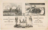
1838WRCAM55549New York: H.R. Robinson 1838. Lithograph 12 1/2 x 20 inches. Light foxing and soiling. Two short closed tears in the right edge and left edge of the sheet. Very good. A very rare print satirizing the recently undertaken United States Exploring Expedition commanded by Charles Wilkes. The Expedition departed in August 1838 and Robinson's eagerness to satirize it and the politicians who supported it is ample evidence that the endeavor was not universally popular. The print is made up of three humorous vignettes. "The upper left is Charles Wilkes in a rowboat with an oarsman and two members of the scientific corps who make observations with a transit or telescope and draw fauna. The upper right image depicts a group of sailors and Charles Wilkes huddled together on the snow surrounded by a ring of polar bears and an upturned rowboat foxes penguins and a campfire. They are flying an inverted U.S. flag to signal distress. At the bottom between the two titles is an inset of the three Navy Commissioners Isaac Chaucey Charles Morris and Alexander S. Wadsworth at sea in a bowl. They are framed by a shield surmounted by a jester and flanked on the left by a man in naval uniform James Kirke Paulding Secretary of the Navy and a sailor with a sad expression on the right" - Harry T. Peters Collection at the Smithsonian Institution online catalogue. The print is "Respectfully inscribed to the Secretaries of the Navy and Army and the Board of Navy Commissioners by their humble servant Robinson Crusoe." <br> <br> Not in Reilly's catalogue of American political prints in the Library of Congress though OCLC does locate a copy at the Library of Congress. That is one of two copies listed on OCLC the other copy is at the American Antiquarian Society. There are also copies in the Peters collection at the Smithsonian and at the Australian National Maritime Museum. OCLC 299947747 752795742. Herman J. Viola ed. MAGNIFICENT VOYAGERS THE U.S. EXPLORING EXPEDITION 1838-1842 Washington 1985 p.13. H.R. Robinson unknown books
182146092(London, W.Bulmer and W. Nicol, 1821). 4to. No wrappers as extracted from ""Philosophical Transactions"" 1821 - Part I. Pp. 164-190 a. 5 folded tables.
182146092London W.Bulmer and W. Nicol 1821. 4to. No wrappers as extracted from "Philosophical Transactions" 1821 - Part I. Pp. 164-190 a. 5 folded tables. <br/><br/><em>First appearance of the paper in which Sabine relates his discoveries with the pendulum on his 2 voyages the first on John Ross' expedition in 1818 - relating observations from Island of Brassa Shetland Hare Island London - and from the second voyage with William Parry on the arctic expedition - relating observations from Melville Island. From these observations he estimated the figure of the earth."An artillery officer Sabine was a graduate of the Royal Military Academy Woolwich. While retaining his commission - Sabine eventually reached the rank of general - the started scientific work at the close of the Napoleonic Wars. On the recommendation of the Royal Society he accompanied John Ross on an expedition to seek the Northwest Passage in 1818 and was with William Edward Parry on his 1819-1820 Arctic expedition. From the latter voyage. he said came the idea of a great ship-borne expedition of “physical discovery†to the southern hemisphere."DSB. </em> unknown
1876100140572Plon et Cie 1876 in4. 1876. Broché.
1873184026Einsiedeln, New York und Cinncinnati, 1873. 423 Seiten. Mit zahlreichen Schwarz-Weiß- Illustrationen. Originalhalbleinen
186914451London & Glascow: William Collins Sons & Company. 1869. Hardcover. With two hundred illustrations after drawings by Gustave Dore Berard Lancelot Jules Noel and other eminent artists and six finely engraved maps full coloured title page reads the same for both volumes. Volume 1 first series - xii 820 pages six finely engraved maps full coloured and four others folding panorama of Jerusalem approx 200 other illustrations some full page Volume 2 second series - xii 810 pages six finely engraved maps full coloured and two others approx 200 other illustrations some full page bound in half leather as a matching 2 Volume set front hinge on Vol. 1 has small split at top new endpapers overall a very good set Heavy books may require extra postage cost. . William Collins, Sons & Company hardcover
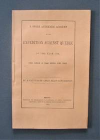
1872R3304Québec: The « Gazette » 1872 "By a volunteer upon that Expedition". Transcribed and edited from the "volunteer's" manuscript notes but never before published. Light foxing on last pages. Soft cover. Fine. The « Gazette » paperback
1828073384London: Longman Rees Orme Brown and Green 1828. "Being Extracts from The Journal of a Detenu Who Continued a Prisoner on Parole in the French Capital From the Year 1803 to 1814. Also Anecdotes of Buonaparte's Journey to Elba." Written by artist Thomas Richard Underwood 1772-1836 and published confidentially at his behest by editor friend John Britton. Full green cloth binding. Title page is loose but present. Patterned endpapers. Small prior bookstore label on front pastedown; prior owner's address stamp on verso of front flyleaf. A small bit of foxing inside some age toning. xix 208pp. plus 4 pages adverts. First Edition. Hardcover. Good/No Dust Jacket. 8vo - 8" - 9" Tall. Longman, Rees, Orme, Brown, and Green Hardcover
180272327London: A. Arrowsmith 1802. A fine and high quality facsimile of this seminal map commissioned in 2001 by renown Lewis & Clark collector Roger Wendlick. Backed on canvas and measuring 150 x 58 inches in color Wendlick commissioned the firm of Ford Graphics of Portland to make this map. Only 21 copies were made and this is the last one with a letter from Wendlick attesting to this fact. Fine. "The 1802 revision of the map of North America on display delineates the complete length of the Missouri River as well as Mackenzie's journey to the Pacific in 1793. The depiction of the Missouri headwaters which Arrowsmith studied from Peter Fidler's drawing of a map by the Blackfoot Indian Ac Ko Mo Ki shows several streams joining into two branches of the Missouri which flow almost due east. The southern branch of the Missouri appears to be the main branch of the river and connects to the Knife River; the northern branch is a good representation of the actual course of the Missouri.Although the revised map still shows a single ridge of mountains in the west a note near the southern sources of the Missouri states: "Hereabout the Mountains divide into several low Ridges." This note which was based on the reports of Fidler Mackenzie and Thompson was more encouraging to Jefferson and Lewis than the note about the Stony Mountains on the 1795 map which unfortunately turned out to be more accurate. Arrowsmith's map situates the Great Lake River on the western slopes of the mountain range and connects this river to the Columbia River with a dotted line. Since another note claims that this river can be descended to the sea in eight days the Arrowsmith map supported the erroneous belief in a convenient route to the Pacific Ocean.Both the 1795 and 1802 versions of Arrowsmith's map served as resources that Nicholas King consulted as he prepared his map for the Lewis and Clark Expedition. Lewis and Clark in fact carried the 1802 Arrowsmith map along on the expedition. Thomas Jefferson owned the 1802 map as well as an 1802 edition of Arrowsmith's map of the United States. Arrowsmith's 1802 map of North America was the most comprehensive map of the West available to Jefferson and Lewis and it was probably the most important map used in the planning of the expedition." University of VirginiaAaron Arrowsmith's 1802 map was the most current and accurate cartographic representation of the American West available to Lewis on the eve of the journey. Lewis studied this edition closely during the summer of 1803 and even carried a copy on the first leg of the expedition. Among Arrowsmith's sources were Indian maps reports and manuscript maps from the British fur trade and British Navy exploration reports and charts of the Pacific Coast. But various elements in the map reinforced Jefferson's misconceptions of western geography among these were depictions of the Rocky Mountains as a single long chain and the headwaters of the upper Missouri River at the eastern edge of the Rockies suggesting those mountains were readily portaged. A. Arrowsmith unknown
18363145New York: Wiley & Long 1836. First Edition . Cloth. Good. 16mo - over 5¾" - 6¾" tall. Green boards. 3vi-xviii268p12 fold out platesillus Some browning on plates. Backstrip needs to be reglued. 3" split on baxkstrip. Early owners name ink on fep 1854. Gilt title on spine From the estate of Levi Lincoln- Lieut George Lincoln MSA Oct 4 1834 <br/> <br/> Wiley & Long hardcover
18911179838Leipzig; F. A. Brockhaus, 1891. XVI; 470 S.; zahlr. Illustr. / Ktn. und X; 518 S.; zahlr. Illustr. / Ktn.; 23,5 cm. 2 fadengeh. Orig.-Pappbände.