DUGUET, Docteur FirminMareMagnum

1 365 résultats
Par le Docteur Duguet, Médecin Général, Inspecteur général du Conseil sanitaire, maritime et quarantenaire d'Egypte, avec une préface de Justin Godart, exemplaire su tirage ordinaire, 1 vol. in-8 br., Les Editions Rieder, 1932, XII-337 pp. avec 8 planches hors texte (16 photos de pèlerins et de Médine, La Mecque, Mina et Arafat) Edition originale, enrichie d'un envoi autographe signée de l'auteur. Cet important ouvrage évoque dans une première partie le pèlerinage au point de vue religieux et social (histoire, obligations religieuses, les caravanes, le chemin de fer du Hedjaz, l'automobile, la voie maritime, les cérémonies religieuses, la visite à Médine, les pèlerinages Chiites) ; dans une second partie, le docteur Duguet évoque le point de vue sanitaire : les pèlerinages d'avant 1866, la grand épidémie de choléra de 1865, les différentes conférences internationales autour du choléra et les diverses épidémies, les pélerinages de 1905 à 1914, puis de 1914 jusqu'à 1924 et la chute du roi Hussein. Enfin, dans une troisième partie, il évoque le Hedjaz moderne (Ibn Séoud et les Wahabites), les pélerinages de 1925 à 1930 et la politique sanitaire nécessaire dans le Hedjaz. Etat très satisfaisant (couv. un peu frottée avec deux taches en dos et second plat, rouss. parfois fortes). Un ouvrage majeur pour l'histoire du pèlerinage à La Mecques mais aussi pour l'histoire des conférences sanitaires internationales, qui se sont dès l'origine fortement intéressé au risque épidémique qui y était lié. First edition, signed by the author. This important work evokes in a first part the pilgrimage from the religious and social point of view (history, religious obligations, the caravans, the Hedjaz railway, the automobile, the seaway, the religious ceremonies, the visit to Medina, Shiite pilgrimages) ; in a second part, doctor Duguet evokes the health point of view : pilgrimages before 1866, the great cholera epidemic of 1865, the various international health conferences and the various epidemics, pilgrimages from 1905 to 1914, then from 1914 until 1924 and the fall of King Hussein. Finally, in a third part, he discusses modern Hedjaz (Ibn Séoud and the Wahabites), pilgrimages from 1925 to 1930 and the necessary health policy in Hedjaz. Fair condition (cover a little rubbed with two spots on the back and second cover, foxing). A major work for the history of the pilgrimage to Mecca but also for the history of international health conferences, which from the outset were very interested in the epidemic risk associated with the hajj. Français
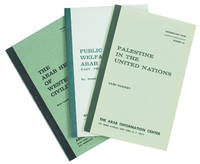
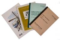
1951ABC_45233New York & London: The Arab Information Center 1951. 2 booklets a magazine and a menu all in original publishers wrappers. 8vo. Comprising:1 EL-KHATIB M. Fatallah foreword. Basic Documents of the Arab Unifications. New York Arab Information Center June 1958.2 OMRAN Abdel-Rahim. Public Health & Welfare in the Arab States: Past Present and Future. New York Arab Information Center November 1959. The booklet opens with a history of the Arab contributions to medicine followed by modern statistics.3 WRIGHT Esmond. The Arab World. Current Affairs no. 125. London Bureau of Current Affairs 3 February 1951.4 MENU. P&O menu. On board the S.S. Arcadia Sunday 25 March 1962. Set of four publications two of which by the Arab Information Center in New York. Together with other Arab information centers in various cities in the Americas Europe and Asia the New York office belonged to the Press and information department of the League of Arab states. As well as the monthly newspaper Arab World the office published numerous research reports on various aspects of the individual member states and the Arab world at large. Ad 1: The most important documents concerning the unification of Arab states. These documents include: the Proclamation of the United Arab Republic the Proclamation of the Arab Union the Provisional Constitution of the United Arab Republic the Charter of the United Arab States and the Constitution of the Arab Union.Ad 2: An overview of both the history of Arab medicine and the current state in 1958 of the demographics and healthcare in various states of the League.Ad 3: A short overview of the Arab world.Ad 4: Menu offered during a cruise in the Gulf on board the S.S. Arcadia.The staples in ad 1 somewhat rusted and ad 2 with an owners stamp. All in very good condition.l MacDonald The league of Arab states pp. 135-138. The Arab Information Center, unknown
1951L95CCFTRZTEWNew York & London 1951. 3 booklets and a menu. 1 EL-KHATIB M. Fatallah foreword. Basic documents of the Arab unifications.New York Arab Information Center June 1958. 8vo. 43 pp. includes: the Proclamation of the United Arab republic the Proclamation of the Arab Union the Provisional constitution of the United Arab republic the Charter of the United Arab States and the Constitution of the Arab Union.2 OMRAN Abdel-Rahim. Public health & welfare in the Arab states past- present and future.New York Arab Information Center November 1959. 8vo. 32 pp. The booklet opens with a history of the Arab contributions to medicine followed by modern statistics.3 WRIGHT Esmond. The Arab World. Current affairs number 125.London Bureau of current affairs 3 February 1951. 8vo. 19 1 pp. Short overview of the Arab World.4 MENU. P&O menu.On board the S.S. Arcadia Sunday 25 March 1962. 8vo. Menu with on front a coloured illustration of a Dhow in the Arabian Sea. Probably offered during a cruise in the Gulf. unknown
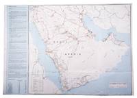
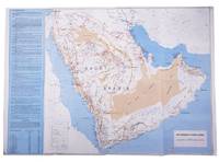
1960L95FL4P9FMHFSaudi Arabia 1960. Colour-printed folding map 48 x 69.5 cm of the Arabian peninsula scale: ca. 1: 5000000 with on the back a city map of Jeddah a plan of the main business quarter of Riyadh a city plan of Dammam a distance table and 8 photographic city views. Folding map of the main roads of Saudi Arabia but depicting the whole Arabian peninsula. On the left of the map text giving information on the climate Riyadh Jeddah Damman Taif the Akrama water dam Alkhobar the telephone system and the exchange rates. The reverse side of the map includes plans of Jeddah Riyadh Dammam and 8 photographic city views. Some minor tears at the folds front partly discoloured and browned but otherwise in good condition. unknown
1588PHO-2120Paris, Hierosme de Marnes & la Veuve Guillaume Cavellat, 1588. Petit in-4 (21,6 × 15,5 cm), [12] ff., 468 pp., [1] f. (achevé d’imprimer, marque de l’imprimeur au verso). Basane fauve mouchetée du XVIIe siècle, dos à cinq nerfs orné, titre doré, tranches mouchetées, reliure un peu usée, frottements et épidermures, petit manque au dos, charnière fendillée, très légères rousseurs, infimes trous de vers marginaux.
1852X114460Göttingen, Dieterichschen Buchhandlung 1852 Complete in 2 parts in one physical volume, [4] + [82] + [106] pp. (containing resp. 24 and 27 genealogical tables), in oblong (23x32cm.), solid modern amateur hardcover (marbled boards, spine in cloth), pages are clean and bright, good condition, [N.B. The "Register" to this work, published in 1853, is not included], weight: 1kg., X114460
L95FAMFT0CG1Karachi Pakistan: printed at Golden block works 1970. Colour-printed folding map 48 x 69.5 cm of the Arabian peninsula scale: ca. 1:5000000 with on the back a city map of Jeddah a plan of the main business quarter of Riyadh a city plan of Dammam a distance table and 8 photographic city views. Folding map of the main roads of Saudi Arabia but depicting the whole Arabian peninsula and including the Sultanate of Oman meaning the present state must have been published in or after 1970. On the left of the map text giving information on the climate Riyadh Jeddah Damman Taif the Akrama water dam Alkhobar the telephone system and the exchange rates. The reverse side of the map includes plans of Jeddah Riyadh Dammam and 8 photographic city views. In very good condition. printed at Golden block works, unknown
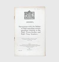
1925163169London: His Majesty's Stationery Office 1925. The confidential nature of Clayton's successive offices necessarily obscured the importance of his achievements First appearance in print first impression of the English text of the Hadda and Bahra Agreements negotiated by Sir Gilbert Clayton and Ibn Saud. The printer's slug records that 1125 copies were printed in January 1926 one month after the agreements were presented to Parliament by Leo Amery the colonial secretary and the future political nemesis of Neville Chamberlain. As Ibn Saud continued to expand his power base in the early and mid-1920s "the turbulent events. precipitated British diplomatic intervention. this led to a series of missions to the Hejaz led by Sir Gilbert Clayton between 1925 and 1928" Leatherdale p. 138. The accords reached in 1925 established a tribunal to rule on frontier disputes and placed limitations on the movements of traditionally peripatetic tribes. On the part of Ibn Saud participation in the agreement was a deliberate diplomatic strategy designed to maintain British neutrality vis-à-vis his broader geopolitical goals. Concerning Clayton M. W. Daly observes that "while colleagues and subordinates such as T. E. Lawrence achieved worldwide fame the confidential nature of Clayton's successive offices necessarily obscured the importance of his achievements" ODNB. Octavo pamphlet pp. 16. Royal coat of arms of the UK on first page. Wire-stitched as issued. Recently pencil ownership signature of one "Mr Simon" on first page. Light toning and creasing rust marks at staples. A near-fine copy of this delicate publication. Clive Leatherdale Britain and Saudi Arabia 1925-1939 1983. hardcover
Beirut, Damascus, Hama, Bhamdoun: 28 February 1900 - June 1901. Lot of 5 manuscript letters written and signed by Harvard anthropologist Henry Minor Huxley, concerning anthropological work performed for the Howard Crosby Butler Archaeological Expedition to the Middle East, as well as a noteworthy archaeological discovery of an ancient and curious stone inscription, its location guarded with secrecy by the few expedition members having this knowledge. 8vo. double-leafs varying in size. 24 pages combined, each letter signed in the original. Two letters are on hotel stationery. Occasional light creasing, otherwise in very good condition, clean and bright, a fascinating and candid primary source account. Writing to a trusted source, his mother, Huxley's reveals the discovery of an ancient inscription carved into an overturned stone, in a language possibly not yet identified, stating that he took the first photograph of it, and that only a select few expedition members are privy to knowing its location. His commentary on experiences with the local civilians and officials are straightforward and occasionally blunt. Henry Minor Huxley, A.M. accepted the offer to join the American Archaeological Expedition led by American archaeologist Howard Crosby Butler. The first part of the archaeological work took place from mid-October to mid-December 1899, and a second trip was made for continued work from March to June, 1900. In the summer of 1900, he was devoted to acquiring a working knowledge of the vernacular Arabic. Huxley's work, however, involved a broader scope. During this second trip, he was also tasked with the study of physical anthropology, as is apparent in the present correspondence. This work proved so valuable that Huxley, owing to the patronage of New York businessman and archeological enthusiast B.T. Babbitt Hyde, remained for another year to further these anthropological observations, independently. What does not appear to be officially documented in publications, but is highly fascinating, is what Huxley writes in his last letter of the present lot. That is, in June 1901, just prior to returning to America, he alone returned to the site of a stone inscription discovered during the earlier part of the expedition (presumably in 1899), to copy it, photograph it, and turn it back face down so that no others would see it. This would increase the likelihood that he and one other would have a better chance of being the first to decipher it.
ORD-14610Nouvelle édition soigneusement corrigée & augmentée de quelques notes. Neuchâtel. Société Typographique. 1772. 1773. 6 volumes in-12 (102 x 168mm) pleine basane racinée, dos à 5 nerfs ornés de caissons, pièces de titre maroquin rouge, de tomaisons maroquin brun, gardes marbrées, tranches rouges, 556, 444, 502, 468, 431 et 448 pages. Etiquette de P. Gauvry libraire à Bordeaux. Coiffes lgt arasées, petits défauts d'usage aux reliures sinon beaux exemplaires. Manque le tome VII comme souvent. Rare.
<span style="font-style: normal;">2 parti in 1 volume in-12° (cm. 16,4), legatura coeva in piena pelle con titolo e fregi in oro al dorso (mancanza della cuffia inferiore); tagli spruzzati; pp. [32] 316 [2] XIV 76 [16] in buono stato con 4 tavole illustrative in rame f.t. di cui una ripiegata (accampamento sul Monte Carmelo davanti alla città di Haifa); sporadiche fioriture. Edizione originale postuma del libro di viaggi compiuti nel 1664 in Medio Oriente dal diplomatico marsigliese, edito da </span>Jean de la Roque. Interessante la<span style="font-style: normal;"> descrizione delle tribù nomadi. «The first part of this work is an account of d'Arvieux's mission to the Arabs of Mt. Carmel in 1664, together with a general discussion of the customs of the nomadic Arabs. The second part, </span><i>Description Générale de l'Arabie</i>, has been translated for the first time into French by the editor La Roque from the Arabic of Ismael Abulfeda» [Blackmer 50]. cfr. Atabey 38. Esemplare molto buono.
In Folio (mm 340x240); 16 carte non num., pagine 1059, (1); frontespizio in rosso e nero; legatura in tutta pelle coeva con dorso a sei nervi, titolo e fregi agli scomparti, titolo su tassello, tagli spruzzati. Buon esemplare con qualche traccia di usura lieve alla legatura, cuffie restaurate. Internamente ottimo esemplare fresco e marginoso, ma occhiello con un restauro, prime carte con piccola mancanza all'angolo inf.<BR>Prima edizione di questa celebre opera fondamentale per la conoscenza del mondo orientale basata sulla immensa bibliografia arabica di Hadji Khalfa (Katip Çelebi), di cui d'Herbelot fece sostanzialmente un ampio compendio aggiungendo però numerose notizie da altre fonti arabe e turche, a stampa e manoscritte. L'opera fu pubblicata postuma, due anni dopo la morte, dall'orientalista Galland. Furono stampate quattro edizioni, l'ultima nel 1781-83.<BR>Atabey, 563: "Herbelot spent the last thirty years of his life working on his Bibliothèque orientale, a landmark in Arabic studies which was unfinished at his death and completed and published two years later by the orientalist Antoine Galland in 1697. He knew a range of languages, including Arabic, Turkish, Persian, Aramaic, Syriac, and Hebrew, and was familiar with their literature and history, of which this work forms an encyclopaedia."<BR>Brunet II, 664; Zischka 15; Graesse II, 376<BR><BR>First edition, folio, pp. [32], 1059, [1]; title page printed in red and black, woodcut ornaments and initials; full contemporary calf, gilt-decorated spine in 6 compartments, red morocco label in 1. Good general condition, edges somewhat worn, some restorations at spine, short-title reinforced and restored, titlepage and next two leaves with minor defects and small lacks at bottom corner. Based on the immense Arabic bibliography (the Kashf al-Zunun) of Hadji Khalfa (Katip Çelebi), of which it is largely an abridged translation, but it also contains the substance of a vast number of other Arabic and Turkish compilations and manuscripts. Four editions of this encyclopedia on the culture and history of the Near East were printed, the last being 1781-83. <BR>Atabey, 563: "Herbelot spent the last thirty years of his life working on his Bibliothèque orientale, a landmark in Arabic studies which was unfinished at his death and completed and published two years later by the orientalist Antoine Galland in 1697. He knew a range of languages, including Arabic, Turkish, Persian, Aramaic, Syriac, and Hebrew, and was familiar with their literature and history, of which this work forms an encyclopaedia." A supplement compiled by Claude de Visdelou was published in 1780. Brunet II, 664; Zischka 15; Graesse II, 376<BR>
in-8 gr., pp. VIII, 196, (4), bella leg. m. pelle coeva con nervi e tit. oro al d. Risguardi in carta color. Testo su due colonne. Macchia di circa 1 cm al margine bianco inf. interno. Belliss. esempl. su carta forte. [208]
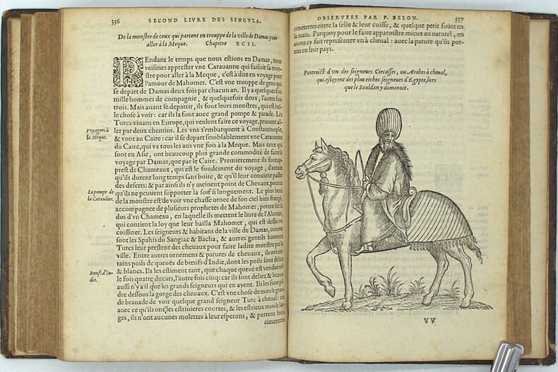
1657PHO-1458A Troyes, par Nicolas Oudot, et se vendent à Paris: Chez François Clousier, 1657. in-4; [6ff. (sur 7: feuillet de dédicace en fac-simile), dont titre, portrait légendé de La Boullaye, préface], 558p., [5ff. Table, fautes, privilège du 12 février 1657]; 33 illustrations sur bois dans le texte dont 16 à pleine page. Reliure d'époque en basane brune, dos à nerfs avec titre , coupes , coiffes et coins usés , frottements. un coin déchiré au titre sans atteinte au texte. Mouillure angulaire au premier portrait P. 73 déchirée avec manque de papier ,sans atteinte au texte. P. 165: manque en coin avec perte de qq mots; PP. 173 et 175: déchirures sans perte de texte; P. 234: manque de papier en pied avec perte de quelques mots; taches d'encre pp. 264 ; pp. 460 à 485: petites galeries de vers marginales en pied. Ex-libris manuscrit Dominium Antonium Biguet. Seconde édition
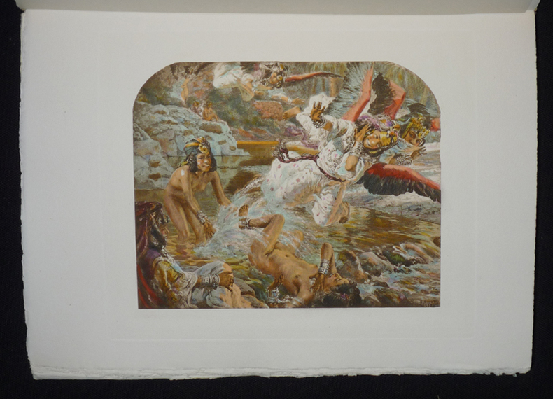
1906ys3303L'Edition d'art H. Piazza Sélection Abraxas-libris Broché sous emboitage 1906 In-8 (17 x 23,4 cm), broché sous emboîtage, couverture rempliée, 222 pages, 1 de 348 exemplaires sur vélin, superbes compositions en couleurs de E. Dinet commentées par Sliman Ben Ibrahim Bamer ; légères pliures au dos, par ailleurs intérieur très frais, bel exemplaire. Livraison a domicile (La Poste) ou en Mondial Relay sur simple demande.
Due volumi (15x23 cm) di LXXXIII-(2)-357 pp; VI-509-(2) pagine. Due grandi carte geografiche ripiegate (56x41 cm) ognuna nella tasca alla fine dei volumi; tre tavole di iscrizioni ripiegate, l' Hassan Ghorab e sua traduzione a p.350 e 351 del vol II, l'Hasan Ghorab nella versione Wellsted a p. 382 del vol II. Una “vignette plate of Nakab el Hajar" all'inizio del Vol II (invece che prima dell'Appendix). Completo quindi delle due grandi carte geografiche dell'Arabia e delle figure indicate nel “directions for the bonder” a fine opera. Legatura editoriale in piena tela con titoli dorati ai dorsi e fregi a secco ai piatti. Ex libris al retro del piatto. Ottime condizioni. Only edition of this detailed study of place names, tribal geneaologies, and pre-Islamic inscriptions. "An attempt at the proof of the descent of the Arabs from Ishmael" (Ghani).
Full Tilte: J.R. Wellsted's Reisen in Arabien. [J.R. Wellsted's Travels in Arabia.] Halle (Saale): Verlag der Buchhandlung des Waisenhauses, 1842. "...Deutsche Bearbeitung herausgegeben mit berichtigenden und erlaeuternden Anmerkungen und einem Excurs über himjaritische Inschriften von E. Rödiger." [German translation edited with corrections and explanatory notes and an excursus on Himyaritic inscriptions by E. Rödiger.] 2 vol. bound together. 8vo. xiv, 312; vi, 412 pages, respectively. First and only German edition. Text is in German. The complete work, with title pages, half-titles, 1 meteorological data chart, and 2 extra-large fold-out maps with multiple insets featuring inscriptions recorded by Wellsted. Brown cloth boards titled in gilt to front and spine, patterned endpapers. Minor age-toning, otherwise in very good condition, exceedingly scarce original maps printed the year of Wellsted's passing. Wellsted conducted the first European exploration of Oman and was the first to penetrate the interior. A successor Samuel Miles who travelled the country forty years later, said that even then, Wellsted's map of Oman was the most trustworthy delineation of the country. Wellsted's exceedingly scarce 1838 map of Oman and his illustrations of Himyaritic Inscriptions found on of the South Coast of Arabia, are here contained in a contemporary and also scarce work. The map of Oman charts Wellsted's route to the interior and along the coast in 1835-36, including dates of arrival and discovery, placing numerous villages Beouin encampments, and springs, also illustrating geographical features encountered by Wellsted and his travel companion Lieutenant Whitelock.
1787585531 vol. in-8 reliure début XIXe demi-basane verte, Chez Volland, Desenne, Paris, 1787, Tome I : 14 pp., 1 f. (errata et avis au relieur), 383 pp. avec 2 cartes dépliantes ; Tome II : 6 pp., 1 f. (errata), 458 pp. et 2 ff. n. ch. (approbation) avec 3 planches hors texte (dont deux dépliantes)
1 vol. in-8 reliure début XIXe demi-basane verte, Chez Volland, Desenne, Paris, 1787, Tome I : 14 pp., 1 f. (errata et avis au relieur), 383 pp. avec 2 cartes dépliantes ; Tome II : 6 pp., 1 f. (errata), 458 pp. et 2 ff. n. ch. (approbation) avec 3 planches hors texte (dont deux dépliantes) Bon exemplaire de l'édition originale, rare, et ici bien complète des 2 cartes dépliantes et des 3 planches hors texte (anciennes étiquettes de cote au dos en queue, cartes interverties, petites piqûres en mors, très bon état par ailleurs). Ouvrage fondamental pour la connaissance de l'orient de la fin du XVIIIe siècle, le "Voyage en Syrie et en Egypte" rencontra un un très grand succès, et joua un grand rôle dans l'idée et la mise en place de l'Expédition d'Egypte menée par Napoléon Bonaparte. Volney's popular and highly-regarded work was the result of three year's travels, a good deal of which time was spent in Cairo. His account has never really been surpassed. Blackmer, 1748 ; Chadenat, 720 ; Gay, 2275 Français
1743PHO-1218La HAYE ,Jean Neaulme, 1743, deux volumes in 4° (260x210mm) reliés plein veau marbré, dos orné à 5 nerfs, pièce de titre, tranches rouges ,(2 plats détachés),coiffes arasées, coins usés, papier bruni ,Épître à Frédéric roi de Prusse imprimé en rouge et noir, XLIV-414pp./IV-192 pp., à la suite extraits de plusieurs auteurs anciens et autres pièces ,178 pp. ,orné de 12 cartes dont 9 dépliantes et 21 planches dont 5 dépliantes, une planche de musique et un fragment de la célèbre carte de Peutinger , ex-libris de Charles Kettaneh Première édition en français,
in-4, pp. (6), 374, bella leg. m. pelle coeva con tass. al d., tagli spruzzati. Front. a due colori. Testo latino e arabo. [136]
2025__3031090470Springer 2025. Hardcover. New. 10.00x7.01 inches. Springer hardcover
The light vessels being the predecessors of the two permanent lighthouses of Ceylon fame, situated some fourteen kilometers apart off the coast of Yala National Park. Two folio documents: April 1869 double leaf true copy of a memorandum on winds and currents at Little Basses; April 1870 single leaf notice to sea captains announcing the temporary lighthouse near the Great Basses, issued by Colonial Secretary Henry Turner Irving (later Governor) and penned in a secretarial hand; both on blindstamped stationery of the United States Commercial Agency of Ceylon measuring approximately 20 x 32 cm. Slight age-toning, otherwise in very good condition, rare documents connected to two offshore lighthouses which are among the most famous in Asia. This fascinating and detailed manuscript lighthouse report, was made prior to the actual lighthouses having been constructed, by a sea captain who lived on the light ship anchored off the Ceylon southern shore for at least seven years, making important observations and providing light for navigators. The first document is an annual report by John Buchanan, master of the light vessel at Little Basses, describing seasonal wind and weather conditions, sea currents, tides, monsoons and storms, over the period of one year. The captain also describes steamships having difficulties making the passage to shore. This document being a true copy of the original made in April 1869 by Thomas Steele, Assistant Government Agent at Hambantota, who took a noteworthy interest in local antiquities and Sinhalese literature. [An admiralty notice based on Buchanan's memorandum, though slightly edited, was published in the London and China Telegraph, Vol. 12, May 16, 1870, and also in The Nautical Magazine and Naval Chronicle for 1870]. Excerpts from Buchanan's lightship memorandum: ".... at Little Basses Rocks, Ceylon, during 13 months as observed from the Light Ship." "January [1869]... It would not be inaccurate to say that a strong current continues throughout January coming from the NNE from the Bay of Bengal setting S.S.W. Sea crossing very rough all the month.... both wind and tide against them...difficult for ships to get to the Northeast. It would be well not to attempt to do so." "February... towards the end of the month the wind becomes much lighter. The northerly current also slacken. Occasionally in the month the Light Vessel swings. In 1868, however, she did not swing until April, while in the current year (1869) she swings in February. During the seven years I have been here, the SW monsoon has not hitherto set in regularly until from the 4th to the 10th of May. This year it has been steady at SW since April 6th. The present year is accordingly an exception to the rule..." "I consider March one of our finest months at the Little Basses... 87º in the shade... Shipmasters going to any part of Burmah need have no cause for hesitation... " "May... the monsoon sets in strong and steady... much rain falls, and thunder and lightning... until about the 20th October..." "June, July, August and September... the S.W. monsoon blows strong and steady... Notwithstanding the extreme difficulty I have been enabled (occasionally at much risk of life and property) to keep up a monthly communication with Pottana Bay [Pothana Bay], and thence by land with Galle." "November... much thunder and lightning... Floating bodies invariably I have observed, set right out to sea, S.S.W. ..." "Summary... There are no regular tides... the N.E. monsoon... during five months without variation. Thus a steamer steering N.N.E., has not only to oppose a three-knot tide opposed to her, but the wind dead against her... some steamers barely make two miles an hour going to the north... When the sun goes to the northward of the Light Ship, there is no more N.E. monsoon... in the event of a vessel making Dondra Head when bound to Galle, which is not uncommon the Master should never attempt to beat to Galle, but recross the line." End Excerpts. "Notice to Mariners, Bay of Bengal. Temporary Lighthouse near the Great Basses" heads the second document, which was issued by Colonial Secretary Henry T. Irving at Colombo in April 1870. Irving became a colonial governor not long after. Here too, prior to construction of a permanent structure, the admiralty anchored a temporary light-vessel upon which was mounted a revolving signal. This announcement came approximately one year before placement of the first stone for the lighthouse, and four years before it would begin operation. Excerpt from Irving's notice to mariners: "... it is hereby notified... that a light-vessel, exhibiting at an elevation of 38 feet above the sea, a red revolving light at intervals of 45 seconds, has been placed... at a distance of 3/4 of a mile from the N.E. rock of the Great Basses Reef... The vessel carries two balls vertical at the Mast Head." End Excerpt. Sir Henry Turner Irving, GCMG (1833-1923) was a British Civil Servant and Colonial Administrator. He first served as acting Governor of British Ceylon. In 1873-1874, he served as Governor of the Leeward Islands. In 1874-1880, he served as Governor of Trinidad and Tobago. In 1882-1887, he served as Governor of British Guiana. He was the first Governor of Trinidad to occupy the Government House, now known as the President's House. Notes on the lighthouses that subsequently replaced the "light-ships" described above: Great Basses Reef Lighthouse is an offshore lighthouse in the south of Sri Lanka. Accessible only by boat, it is located on a reef 13 km off the coast of Yala National Park, near Little Basses Reef Lighthouse. The necessity of a lighthouse at this location was acknowledged in 1856, a design of an iron tower on a granite base was suggested and costs began to be incurred without fruition. A new design by Alexander Gordon and Sir James Nicholas Douglass was approved in 1867. The executive engineer in charge was James' brother William Douglass. Two steam vessels were used, each capable of carrying 120 tonnes of stone, and each equipped with the appropriate lifting gear. Each support block weighed 2 to 3 tons. The first stone was laid in December 1870, the last in late 1872 and the light was lit in March 1873. The cost had been £63,000, of which £40,000 had been expended to no effect before Trinity House and William Douglass were involved. Little Basses Reef Lighthouse is an active offshore lighthouse at the southern end of Sri Lanka. It is located on a reef called Kuda Ravana Kotuwa (Fort of Little Ravana), formerly called Little Basses by the British when they invaded Ceylon. It is fourteen km off the coast of Yala National Park and north east of the Great Basses Reef Lighthouse. It was completed in 1878, built by William Douglass using the same steam ships, crew and workers as the Great Basses Reef Lighthouse. Designed by Sir James Nicholas Douglass, Little Basses lighthouse was one of a limited number of lighthouses that were designed to house the large Hyperradiant Fresnel lenses that became available at the end of the 19th century. Four of these lenses were used in Sri Lankan lights, all made by Chance Brothers in England. The lighthouse is close to Daedalus Rock, site of the sinking of HMS Daedalus (1811). The two Basses lighthouses are among the most famous offshore lighthouses of Asia. Manuscript
Small octavo, original pale green cloth. Very good condition in the rare dustjacket. First and only edition of this scarce guidebook to the Persian Gulf, illustrated with 16 half-tone plates from photographs by the author and three maps. This scarce guidebook was written shortly after the beginning of full-scale oil drilling in the region, and includes chapters on Bahrain, Kuwait, Qatar, the Trucial Coast (modern-day United Arab Emirates), and Muscat Oman, covering local history, society and culture, with a chapter on the pearl industry. Tweedy writes that Doha is "practically untouched by the progressive hands of the West and the camels and donkeys outnumber the motor-cars how long this simplicity will last is hard to say, for the enormous increase in oil revenues must inevitably affect the lives of all" (39-40).
In.-8°; 2 voll. rilegati in piena pelle con tasselli e titolo in oro al dorso, tagli in rosso. 1- pp. (4), xxiv, 464, (2). 2 - pp. (4), 518, (2) con 3 tavole f.t. ripiegate incise su rame, tra cui una che raffigura la pianta della città di Gerusalemme. Nel testo testate e finalini incisi su legno. Brunet 28372