Ocean Studies BoardBiblio.com
1 884 résultats
660554-nnew. unknown
660554like new. unknown
In 8. Dim. 19x12 cm. Pp. 281+(3). Interessante opera di viaggi del 1886 di Albert David che descrive il suo viaggio lungo l'Oceano Pacifico.<BR>All'interno sono presenti dieci incisioni fuori testo che mostrano vedute: Baie Borja, Lima, Indiani peruviani, Tahiti ecc... Tra i luoghi descritti: Distretto di Magellano e Canali laterali della Patagonia, Lima durante vl'occupazione cilena, Valparaiso e i Cileni dopo la Guerra del Pacifico, Peru e Cile, Callao, Pisco, Pisagua, Arica e Tacna, Iquique, Lota, Una necropoli degli Incas, Honolulu, Un mese a Noukahiva, Tahiti ecc...<BR> In buone condizioni e completo Copertina editoriale in buone condizioni generali con lievi usure ai margini e dorso. Legatura in buone condizioni. All'interno le pagine si presentano in buone condizioni con fioriture. Interesting work of travel of 1886 written by Albert David describing his travel in the Pacific Ocean.<BR>Inside there are ten out of text planches showing different views: Baie Borja, Lima, Peruvian Indians, Tahiti ecc... Between the places described: District of Magellano and channels of Patagonia, Lima during Chile occupation, Valparaiso and Cileni after Pacific war, Peru and Cile, Callao, Pisco, Pisagua, Arica e Tacna, Iquique, Lota, a city of Incas, Honolulu, a month in Noukahiva, Tahiti ecc... In good conditions and complete. Editorial cover in good general conditions slightly worn in the edges and spine. Binding in good conditions. Inside pages are in good conditions with foxings.
Hagman, Tore and PhotograIn Pristine Condition. unknown
5336PARIS, Les Éditions de Paris, 1948 - In-8, 20x13,5 - broché - 318 et (2) pages; 1 hors-texte photos N&B HT - carte sur double page.- bon exemplaire
PARIS, Les Éditions de Paris, 1948 - In-8, 20x13,5 - broché - 318 et (2) pages; 1 hors-texte photos N&B HT - carte sur double page.- bon exemplaire
Very Good English, Middle (1100-1500) Original imitation vellum. An OCLC register says "decorated with small shells and seaweed pasted on". Chipped on extremities and spine, slight pouring on paper; several tapes used at the link of the pages to binding. Otherwise a good copy. Small 4to. (27 x 18 cm). In Middle English (15th century). The first leaf attached to front cover. At end, 6 blank leaves. [46] p. with [7] blank pages, many illustrations, 1 letter with its broken seal. Separately, a facsimile of a letter from Isabella (Dona Isabel por Gracia de Dios Reina de Castilla y Leon etc. etc. A Don Cristobal Colon de Genova) to Columbus, dated 'Granada a? trece de Abril de MCCCCXCII,' with a broken seal attached. Script on vellum as well. Two registers in OCLC (1029665801 and 60764823 -This one is New York Edition-). 'Düsseldorf Edition' says "A spurious work purporting to be the logbook of Christopher Columbus, which, according to legend, he threw into the sea during a storm, and which was found on the coast of Pembrokeshire 400 years later. Written in antiquated English, with paper and binding made to imitate in color and appearance a volume damaged by exposure to seawater. "S.A.S.X. MY XPO FERENS" from cover, variously interpreted, eg. Supples servus altissimi Salvatoris Xristi Mariae Josephi Xpoferens. Forgery attributed to Karl Maria Seyppel. Printed by lithographic process on imitation parchment paper. Text and illustrations printed to appear handwritten, with many decorated initials. Accompanied by: reproduction of a letter purported to be by the finder of the logbook dated "September forth 1890"; "Don~a Isabel por gracia de Dios Reina do Castilla y Leon, etc., etc. a? Don Cristo?bal Colon de Ge?nova," supposed letter on imitation parchment, authorizing his voyage, dated "Granada, a? trece de abril de mccccxcij," with an attached seal, laid in.". This is a fine hoax on Colombus' first travel into America. It includes a map containing Cuba, San Salvador, and unknown areas with a hand drawing of Columbus as well as other illustrations and decorative borders, etc. This Edition may be printed in memory of the 400th year of '1492'. "Columbus's log of the first voyage has not survived, although we do have an abstract of it, written in the 1530s by Bartolome de las Casas. However, that actually used the "Barcelona Copy" of Columbus's original log. The chart above shows the sources that exist today in green, and sources that have disappeared in red. The chart also shows where secondary souses got their original information. When he returned to Spain in 1493, Columbus gave his original log to the Sovereigns at the royal court in Barcelona. Queen Isabela ordered the log to be copied, resulting in the so-called Barcelona Copy. The original has not been seen since, however, the Barcelona Copy was returned to Columbus just before his second voyage later that year, and remained in his possession until his death in 1506. It then passed into the hands of son Fernando, who used it when he wrote a biography of Columbus in 1538. The Barcelona Copy too was lost sometime after 1554. Sometime around 1530, the Barcelona Copy was abstracted by Las Casas into the Diario. This abstract as part of his research that led to his massive work, the Historia de las Indias. So The Diario remains our best historical record of the first voyage of Columbus. On the westward passage, Columbus kept two sets of distance figures in the log. According to Las Casas, this was done to allay the fears of the crew that they had sailed too far from Spain. The abstract is mostly written in the third person, but there are a number of large direct quotes from the log written in Columbus's own first-person.". (Source: Christopher-Columbus Europe website).
18762754Paris, Imprimerie Nationale, 1876. In-8 broché de 226 pp., couverture bleue imprimée.
18752755Paris, Imprimerie Nationale, 1875. In-8 broché de 207 pp., couverture bleue imprimée.
18772756Paris, Imprimerie Nationale, 1877. In-8 broché de 268 pp., couverture bleue imprimée.
Very Good Turkish, Ottoman (1500-1928) Full morocco in Ottoman style. Large roy. 8vo. (25 x 18 cm). In Ottoman script (Old Turkish with Arabic letters). 62 p., 18 unnumbered b/w photos, and four b/w maps. Slight foxing on extremities. Otherwise a very good copy. First and only edition of this exceedingly rare first book on Muslims and Islam in the Comoro Islands of Africa, located in the Mozambique Channel to the north-west of Madagascar and facing Mozambique, including Ngazidja (Grande Comore), Ndzuwani (Anjouan), Mwali (Moheli) and Mayotte (Maore) Islands. The book gives detailed information about the races, customs, and traditions of the natives of the archipelago, the introduction of Islam to the islands, and how influential it was on the people as well as on their education, social structure and the population of the archipelago. The work carried out in the context of missionary activities is also discussed in detail, and such information is supported by photographs, statistical tables and chronology of the islands. According to the information given in the work, Muslims first came to Yuhana Island in 750 AD and began to settle on the island. Since 854, there are claims that the Ismailis, a Shiite community, and then the Fatimid prince came to the islands and ruled for a period. Especially Arabs, Iranians, and Indians, who came and settled on the islands mostly for trade or travel, introduced Islam to the islands' natives, strengthened their ties with marriages and thus increased the population and influence on the islands and became instrumental in the establishment of Islam. Okday also describes the process of French exploitation that started when Comoros fell into the hands of the French, each of whom was under the control of the Malagasy despite England and Germany, and got the support of their pirates. This book has rich and attractive photos of natives of the archipelago, and other peoples who lived on the islands like Arabs, traditional homes and streets, Sultan Ahmad of the Comodo, statesmen and clergies, Prince Said Mohammad, women, and a French ship named 'La Bourdonnaise' as well as four maps showing the African continent and each of the islands. Ismail Hakki Tevfik Okday was an Ottoman intellectual and military commander, who participated in the First Balkan War, the Great War, and the Turkish War of Independence. He was born in Athens as the son of Ahmet Tevfik Pasha, who was then the Ottoman Ambassador to Greece, and later became the last Grand Vizier of the Ottoman Empire. Only two printed copies in OCLC: 949523840 (Bogaziçi University and Stanford University Libraries).; Özege 131.
1683LBW-2314[1683]. 142 x 103 mm.
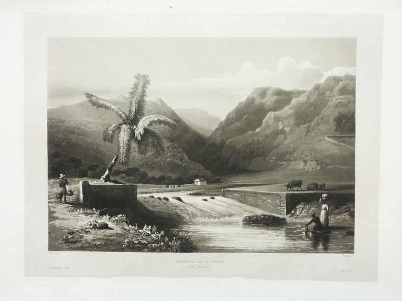
1833LBW-1987Paris, 1833-1839. 272 x 365 mm.
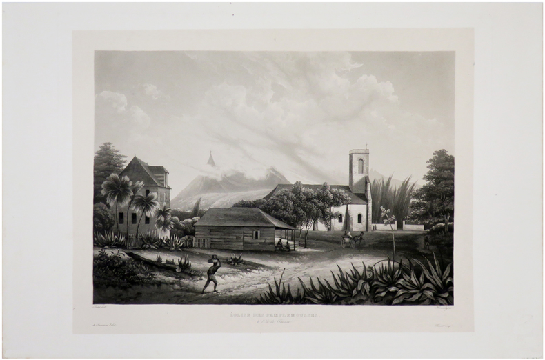
1833LBW-1982Paris, 1833-1839. 267 x 356 mm.
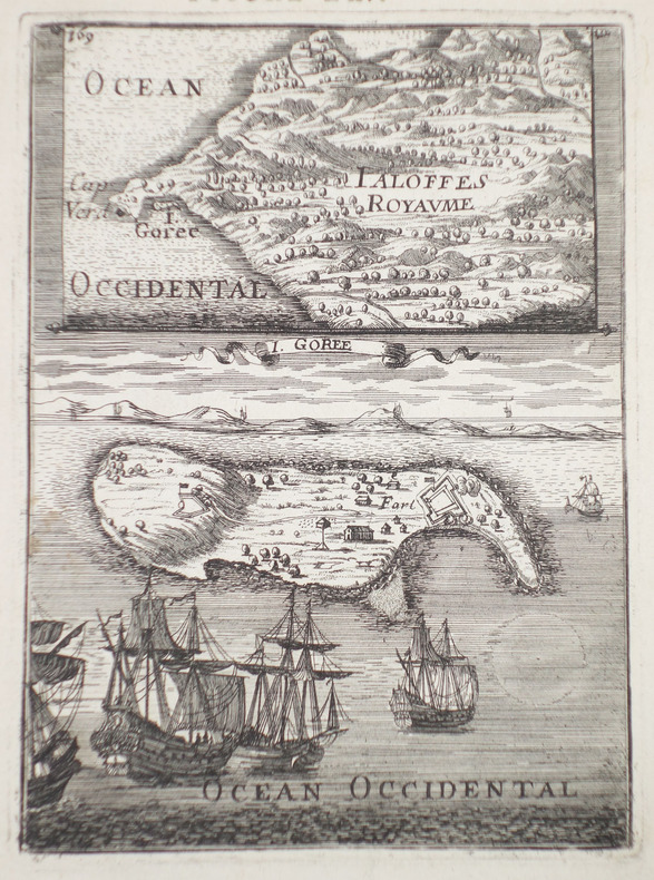
1775LBW-1276[1775-1781]. 331 x 482 mm.
Very Good English Original wrappers. 4to. (29 x 22 cm). In English. 41 p., 31 original gelatin silver photographs in various sizes mounted on pages within the text, many architectural plans of the bridges, with a folded page, and a folded map. The title, author, and contents are on the front cover with a handwritten date "1966". The first two pages are folded inside. Exceedingly modern rare printed material with original gelatin silvers including a detailed historical, scientific, and visual account of the highway bridges in all of Japan, by Dr. Eiichi Murakami, the Director Public Works Research Institute Ministry of Construction of Japan. The book starts with a General title containing two tables: "Present condition of Highway Bridges in Japan 1965", and "Longest Span Bridge by Types in Japan". The second part is the History of Highway Bridges. This part deals with some selected examples from the oldest bridge on record, Ikuinotsu built in 326 AD to present, and this part has three original silver gelatins of Enkyo (Monkey) Bridge, Kintai (Shining Arch) Bridge, and Aimoto Bridge. The third and fourth part is "Specifications" and "Influence of Earthquake upon Bridge Structure" discussing its history from 1921 to the present day and the effects of an earthquake upon a bridge, these parts have one photo mounted on the sixth page as well as two tables. The fifth part is "Steel Bridges" and also is the longest part of the work, with examples from the first metallic bridge in Japan "the Kanenohashi" [i.e. Iron Bridge] constructed in Yokohama in 1869 to the present day, including 18 original silver gelatins of Eitai Bridge, Tied Arch over the Sumida River in Tokyo (its a panoramic view), Sagami Grand Bridge, Nagara Bridge, Azuma Bridge, Jogashima Bridge (this consists of two separate photos), New Tsukuda Bridge, Biwako Grand Bridge, Choshi Grand Bridge, New Mikuni Grand Bridge, Ondo Grand Bridge, Asahi Bridge, Uwagawa Bridge, Takumo Bridge, Saikai Bridge /two different views of this bridge), Konaruto Bridge, Kachidoki Bridge, and the Side-view of Wakato Bridge under construction. The sixth part deals with the subject of Reinforced Concrete Bridges including three gelatin silvers of the Nihon Bridge, Tokachi Grand Bridge, and Sasatsu Bridge. The seventh part is "Prestressed Concrete Bridges". It was in 1952 that prestressed concrete was first industrialized in Japan. This part tells that the studies for industrialization had been made earlier, but implementation had been delayed partly due to World War II and it follows the technique to the present day with five gelatin silvers of Sataunai Bridge, Ranzan Bridge, Komekami Bridge, Koshinoo Bridge, and Nada Bridge, pp. 25-28. The eighth part is "Substructures", including a gelatin silver Steel caisson for the main tower foundation of the Wakato Bridge, towed 20 km across the ocean. The ninth part is "The Amakusa Highway" which is a link between Misumi-cho, Uto-peninsular, and Aizu, Kamishima-Island. This part deals with the project which has a total length of 16,5 km including five bridges on the route made by the Japan Highway, this part has five plans. The last part is "Proposed Highway Bridges across the Bay and the Sea", including 16 plans (one folded). The book has an extra folded large map (58x45,5 cm) in Japanese and a folded page. This item is from the library of Turkish certificated engineer Alkut Aytun (1937-) (dated on the front cover "6/IV/1966"). During the time he worked at the Earthquake Branch of the Ministry of Development and Settlement, he specialized in earthquake engineering as a UNESCO scholar at the International Institute of Seismology and Earthquake Engineering (I.I.S.E.E.), which was established in Tokyo (Japan) with the cooperation of the United Nations and the Japanese Government, between August 1965 and August 1966. This was followed by an extension study at the University of Tokyo under the supervision of Atsushi Hirai with a scholarship from Waseda University unti
1771LBW-8276[Paris, 1771-1786]. 235 x 185 mm.
1849LBW-8266[Paris], Dépôt-Général de la Marine, 1849. 612 x 886 mm.
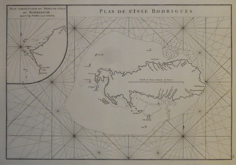
1775LBW-6789Dépôt-Général de la Marine, [1775-1781]. 490 x 331 mm.
1843LBW-8791[Paris], Dépôt-Général de la Marine, 1843. 440 x 576 mm.
1845LBW-6950Paris, [1845]. 303 x 430 mm.
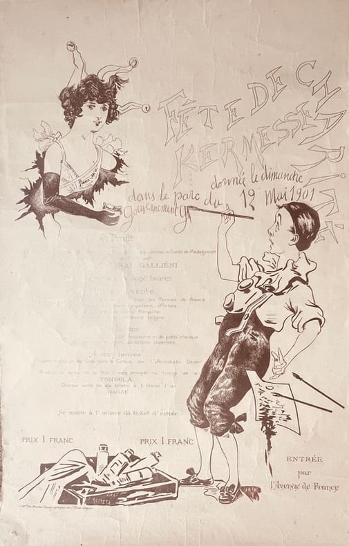
190144540Tananarive, Lithographie du Bureau Topographique (État-Major), 1901. Affiche imprimée (55 x 36 cm).
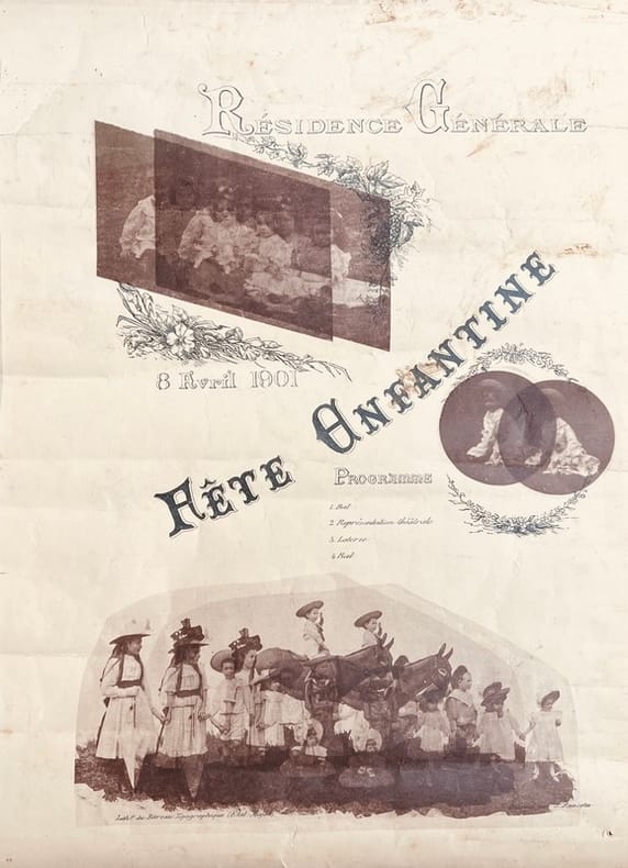
190144538(Tananarive), Lithographie du Bureau Topographique (État-Major), 1901. Affiche imprimée recto verso, illustrée de 3 reproductions photographiques (43 x 31,5 cm).
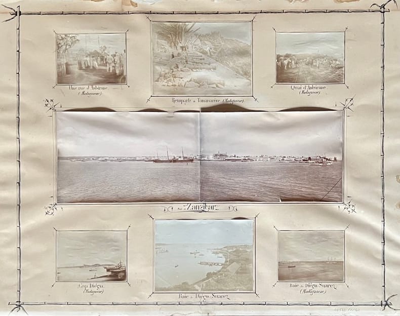
190144542, , 1901. 50 photographies en tirage original d'époque de formats divers (de 6 x 5 à 17 x 11 cm environ), disposées et contrecollées sur 4 planches ornées et légendées à la plume (63,5 x 49,5 cm).
1850LBW-4478Paris, Victor Delarue et Ce, [circa 1850]. 245 x 303 mm.