Biblio.com

2 675 résultats
1969013985Oregon City OR: Clackamas County Historical Society 1969. Softcover. Very Good. Wraps; 380pp; Covers clean & bright text unmarked binding is tight VG condition. Seven consecutive issues of the Clackamas County Historical including 1958/1959; 1960; 1961; 1962/1963; 1964/1965; 1966/1967; 1968/1969. Illustrated with photos. Clackamas County Historical Society paperback
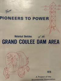
197612436Grand Coulee Dam Bicentennial Association 1976. 1st Edition . Soft cover. Poor. 4to - over 9¾ - 12" tall. Historical Sketches of the Grand Coulee Dam. 467 pages. White paperback. <br/> <br/> paperback
192210415Santa Maria California: Pacific Coast Publishing Co 1922. Second and Revised Edition. Hardcover. Good to Good . 8vo. pp.232 white oil cloth covers table of contents a number of blank pages for hand written recipes throughout the text. -- Spine protected with clear tape. frontispiece of the Presbyterian church; has big chip out top front corner. Inside paste down and blank side of the frontispiece has hand written recipes local advertising interleaved throughout the text. Page 122 has bottom quarter of text obscured with pasted in recipe. Page 123 has pasted in recipe obscuring most of an advertisement. A couple of more pages have hand written recipes obscuring recipes or pasted over a blank page. A few newspaper clipping recipes laid in loose. -- Binding sound. Pacific Coast Publishing Co hardcover
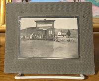
9374Photographer Unknown No Date circa late 19th century. Very good. card mount 7"x9". Actual photograph 5"x7" Photographer Unknown unknown
1914101621914. Very good . 4-1/4"x3" copper chain for hanging. -- Advertising promotional piece with mini calendar attached dated 1914. Photograph is under glass with wooden frame backing.-- Some wear to the calendar. Overall Condition. unknown
1870354322San Francisco: Thomas Houseworth & Co 1870. Single stereocard 3½ x 7 inches. Stereo image mounted onto printed orange cardstock. Slight wear at edges. Very good. Single stereocard 3½ x 7 inches. A very attractive single stereocard image of the Central Pacific Railroad's "Long Ravine Trestle Bridge." The bridge is located in Nevada County California in the Sierra Nevada mountain range just west of the Nevada state line. The image comes from a set sixty-two stereocards created by Thomas Houseworth & Company for the railroad some time after the railroads completion in 1869. According to the website of the Central Pacific Railroad www.cprr.org the Houseworth company produced more than one hundred such stereocards for the railroad including more than a dozen views of the 878-foot long Trestle Bridge. A nice early stereoscopic image of an engineering wonder from an important American railroad. Thomas Houseworth & Co unknown
1870354323New York: E. & H.T. Anthony & Co 1870. Single stereocard 3½ x 7 inches. Stereo image mounted onto printed orange cardstock. Slight wear at edges. Very good. Single stereocard 3½ x 7 inches. An appealing stereocard image showing several long stretches of railroad track heading into the small town of Ogden Utah. It is a view of an important point crossing point in American railroad history as Ogden is the point at which the Union Pacific Railroad ends and the Central Pacific begins. A train can be seen on the tracks in the far distance as well as a few clapboard buildings. The New York photographic firm of E. & H.T. Anthony & Co. produced several stereoscopic views for the Central Pacific Railroad though few are known today. A nice image of an important railroad intersection. E. & H.T. Anthony & Co unknown
1900373823St. Louis 1900. 34 photographs mounted recto and verso on 17 cards with printed album title on each the images captioned in the negative on linen guards. Oblong small folio 10-1/8x12-1/2 inches. Contemporary half calf and cloth covered boards titled in gilt on the upper cover leather perished contents loose. The images generally dark printings in good condition. Provenance: Battery Park Hotel Asheville NC presentation in gilt on the upper cover from H. C. Townsend Gen'l Pass'r and Ticket Agent St. Louis. 34 photographs mounted recto and verso on 17 cards with printed album title on each the images captioned in the negative on linen guards. Oblong small folio 10-1/8x12-1/2 inches. The images by an unindentifed photographer comprise lovely compositions of buildings and scenes along the route in Missouri Kansas Nebraska and Arkansas. OCLC locates only a single example at University of Texas Austin. unknown
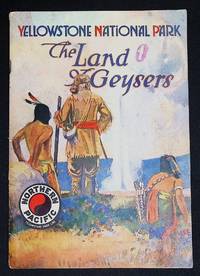
20933Very Good/No Dust Jacket As Issued. Publisher: Northern Pacific Railroad<br /> Date: 1913<br /> Format: Small illustrated booklet promotional/advertising ephemera<br /> Subjects: Yellowstone National Park Geysers Early 20th-century travel Northern Pacific Railroad<br /> Genres: Travel Tourism Ephemera Railroad Advertising<br /> <br /> Stapled color illustrated wraps; 6 by 8.5 inches; 48 pages with b/w photo illustration and map of the area. The bindings are tight and square. Text is clean; light even age-toning. Moderate shelf handling wear. It appears someone added an 'O' in pink to the title. Stapled color illustrated wraps; 6 by 8.5 inches; 48 pages with b/w photo illustration and map of the area. The bindings are tight and square. Text is clean; light even age-toning. Moderate shelf handling wear. It appears someone added an 'O' in pink to the title.<br /> <br /> This 1913 promotional booklet was issued by the Northern Pacific Railroad to entice travelers to visit Yellowstone National Park during the summer season. It highlights the natural wonders of the park-geysers hot springs waterfalls and scenic landscapes-while presenting travel itineraries accommodations and services offered along the Northern Pacific routes.<br /> <br /> Booklets of this type were part of the railroad's early 20th-century marketing strategy designed to encourage tourism to the American West by emphasizing convenience safety and modern travel amenities. <br /> <br /> These advertising booklets serve as both marketing tools and historical documents providing insight into early tourism railroad promotion and perceptions of national parks. Collectors value them for their artistic design period typography and evocative imagery as well as for the information they preserve about travel lodging and leisure in 1913.<br /> <br /> REF: Malone Haines unknown
187072298Philadelphia: Jay Cooke & Co. ca.1870. First edition Octavo. 46 2 ads pp. Cover printed in red and black. Original printed wrappers with a map of the railroad's line on rear small piece excised but not affecting map and an old center crease. Very good.One of the ads is for development in Montana and bears a letter from Governor Potts. Includes - "Puget Sound-Its Harbors. Climate and Resources."Together withSpecial Report of a Reconnoissance of the Route for the Northern Pacific Railroad between Lake Superior and Puget Sound via the Columbia River Made in 1869 by W. Milnor Roberts U.S. Civil Engineer. Philadelphia: Jay Cooke and Co. ca. 1870. First edition. Octavo. 51 1 4 ads pp. Publisher's printed wrappers. Very good. Jay Cooke & Co. unknown
192175088St. Paul: Northern Pacific Railway Company 1921-1930. First edition. Ten consecutive issues. Folio 12 x 9 inches. Variously paginated. Many charts but no illustrations. All but the Twenty-seventh and the Thirty-fourth Reports have large folding maps bound in at rear of report. Original printed wrappers and all bound together in a stabbed-and-sewn black cloth binder. Very good.The Northern Pacific Railway reporting mark NP was a transcontinental railroad that operated across the northern tier of the western United States from Minnesota to the Pacific Northwest. It was approved by Congress in 1864 and given nearly forty million acres 62000 sq mi; 160000 km2 of land grants which it used to raise money in Europe for construction. Construction began in 1870 and the main line opened all the way from the Great Lakes to the Pacific when former President Ulysses S. Grant drove in the final "golden spike" in western Montana on September 8 1883. The railroad had about 6800 miles 10900 km of track and served a large area including extensive trackage in the states of Idaho Minnesota Montana North Dakota Oregon Washington and Wisconsin. In addition the NP had an international branch to Winnipeg Manitoba Canada. The main activities were shipping wheat and other farm products cattle timber and minerals; bringing in consumer goods transporting passengers; and selling land. The Northern Pacific merged with other lines in 1970 to form the Burlington Northern Railroad which in turn merged with the Santa Fe to become the BNSF Railway in 1996. The main interest here is in the very detailed maps. Northern Pacific Railway Company hardcover
161775296San Francisco: Pacific Gas and Electric Company 1916-17. A complete year; May of 1916 to June of 1917 12 issues Octavos. Contiguously numbered from p.1 to p. 466 plus some roman numeral pages in each issue for ads. An abundance of maps charts and photographs illustrations. Grey cloth with gilt spine lettering. All issues with their colorful wrappers bound in. An excellent little gathering.There cab be no progress without electricity so these magazines chart in a very realistic manner the growth of the state of California. The very fist article is a history of the union Iron Works of San Francisco with a full page illustration of the foundry but most of the articles are more area specific. Such articles as - ; Modernizing the San Jose Gas Works; An old-Established California Industry-the Judson Manufacturing Company; The San Francisco Dairy Company; Raising Lake Spaulding Dam; Our Pit River Project; The Rebuilding of he Sonoma County Gas Properties; Pacific Service at the Oakland Kinema Theatrte etc. . Toward the latter issues WWI starts making its appearance in the plea for war bonds. Pacific Gas and Electric Company hardcover
191476234San Francisco: Pacific Gas and Electric Co. 1914. First and only edition. Quarto 9 x 11 1/2 inches. 4 double leaves 12 double leaves of colorized photographic illustrations. Publisher's quarter brown boars over green boards green endpaper to match. Head of spine a but bumped else a bright and fresh copy.The color illustrations are all of P.G. & E works and include; Electra Power House; Cordelia Substation;De-Sabla Power House; Paterson Ranch Pumping Plant; Centerville Power House; Carquinez Straits Crossing; Spillway-Spaulding Damn; Potrero Gas Works; San Rafael Substation; Colgate Power-House; Brown's Valley Ditch; Champion Mine-Nevada County.Ostensibly issued as a keepsake for Christmas of 1914 the real reason was likely to brag about the completion in 1913 of the huge Big Creek plant the gem of the P.G & E system. It is estimated that there were over 100 hydroelectric plants operational in California by 1914. These ranged from small local plants to large-scale projects supplying power to major cities. This was a very deluxe item so it is probable that PGE presented it only major stockholders This is borne out by the fact that OCLC only records 9 copies Printing colorized photographs in books in 1914 was a very complex and costly process. Special paper had to be used thus the french-fold binding here and the technology was still in its nascent form. But the illustrations fairly burst with color. This was at P.G. & E.'s most muscular; in the 21st century the company filed twice for bankruptcy. (Pacific Gas and Electric Co.) hardcover
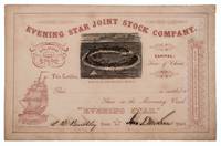
1862332701San Francisco: Towne & Bacon Printers 1862. Unaccomplished stock certificate for shares in a missionary vessel going to the Gilbert Islands Micronesia with a woodcut view of a tropical island printed in black the rest printed in red. Signed by John T. McLean and L. B. Benchley. 5-1/2 x 8-1/2 inches. Fine. Unaccomplished stock certificate for shares in a missionary vessel going to the Gilbert Islands Micronesia with a woodcut view of a tropical island printed in black the rest printed in red. Signed by John T. McLean and L. B. Benchley. 5-1/2 x 8-1/2 inches. The woodcut is signed by Loomis and shows a tropical atoll with palm trees small huts and several sailing vessels. The prospectus for the company survives at the University of Hawaii at Manoa dated 1862 and titled: Proposals for forming a children's Joint Stock Company for the purchase of a missionary vessel for the Gilbert Islands Micronesia. <br/><br/> Towne & Bacon, Printers unknown
185275869Oregon City: Surveyor General's Office 1852. First edition. 15 3/4 x 26 inches. Printed in various shades of green blue red and black. Some light toning long fold-lines else a very good map of a vastly underpopulated Territory.The map above shows the surveyed portion of the Oregon Territory as of October 21 1852. It was prepared by John B. Preston first surveyor general of Oregon."With the establishment of the Oregon Territory on August 14 1848 all grants of claims of land in the territory were nullified. It was not until the passage of the Donation Land Act on September 27 1850 that new provisions were made for acquiring unclaimed land to be based upon government surveys. John B. Preston was appointed first surveyor general of Oregon where he arrived on April 20 1851. On June 7 1851 Preston drove the “starting stake†for the base surveys of the territory at what is today known as the Willamette Stone. The east-west Willamette Base Line and the north-south Willamette Meridian still define surveying and legal land descriptions in Oregon and Washington state.Preston and his crew were able to carry out their surveying and mapping to the extent depicted on this map in just over one year. Each square of the grid termed a section is one mile on each side and includes 640 acres of land—the maximum acreage allowed for a married couple making a claim under the Donation Land Act; a single man could claim up to 320 acres. Thirty-six sections make up a township.The surveyors took careful note of waterways hills prairies and roads. Some recognizable places are already viable communities such as Salem and Lafayette; other communities of the period—Champoeg Fairfield Cincinnati for example—have vanished as meaningful places. All three of those were river landings that were affected by floods channel changes and the eventual disappearance of river transportation. Notably absent from the map is Mission Bottom or Mission Landing the by-then-abandoned site of the Methodist mission of the 1830s and St. Paul on French Prairie. The roads that are mapped include ancient routes such as the California-Oregon Trail which had sections that paralleled both sides of the valley as well as newer roads established in recent years. The roads converging on Salem from the outlying farming districts for instance reflect its recent importance as a mill town powered by the waters of Mill Creek Surveyor General's Office unknown
190574076Portland : Printed by Himes & Pratt for the Grand Centennial Fair 1905. First edition of this map of the Columbia Basin published on the occasion of the Lewis & Clark Centennial. 28 x 21.5 cm colored. The verso contains a bit of boosterism called "Portland's Inner Trade Area" by D. H. Stearns. Two old fold-lines else fine.There is only one copy of this map located by OCLC and it is obviously a facsimile published by the Oregon Historical Society. Their facsimile is quite a bit smaller and the verso bears the letterhead of the Oregon Historical Society. D. H. Stearns was an early immigrant to Oregon. In 1866 after serving in the Civil War he left his wife in Virginia and moved to Portland. There he was involved in many pursuits including being the founder of the very influential Republican newspaper The Portland Bee. His article is a long reassurance to people thinking of coming to Oregon that there is still plenty of government land available in the eastern part of the state. Printed by Himes & Pratt for the Grand Centennial Fair unknown
MA09A-06276A. O. P. Nicholson. Collectible - Acceptable. Washington: A. O. P. Nicholson 1855. Volume 1. 4to. viii134vii651pp. Tables. Fair book. Ex-library. Half leather binding. Spine ends worn spine cover rubbed spine label chipped. Boards rubbed and edgeworn; board covering peeling off on front board at top corner and back board at free edge. Board corners frayed. Library shelfmark on spine tail bookplates library and gifter's on pastedown. Front hinge and endpapers slightly dampstained. Binding cracked at signatures 15a 11f; most severely at 26f 47f and 54f. Pencil notations inside. Inquire if you need further information. A. O. P. Nicholson hardcover
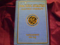
1929217023np.: General Electric. 1929. First edition. . Decorated hard cover. . Fine copy very light soiling to covers. 4to. Illustrated. Important reference work. Very scarce in this condition. General Electric. hardcover
26753Honolulu: Paradise of the Pacific Press 1914. Special Panama-Pacific International Exposition Edition. Pages 64 pp.24mo. Paper bound. Special Panama-Pacific International Exposition Edition. Illustrated throughout w/ black & white photographs & map. Final page contains a nice Mark Twain quote. An extra set of pages 1 through 12 and 53 through 64 are bound in. Else in fine condition. Honolulu: Paradise of the Pacific Press 1914. unknown
190074021Port Townsend WA and others: N.p. ca. 1900. Original quarto album of full morocco measuring 9 1/2 x 6 1/2 inches. There are 24 think leaves mounted on stubs with each leaf bearing four windows for photographs measuring 3 7/8 x 2 7/8 inches. Most of the leaves in the rear bear no photographs but in the front there are 64 inserted silver gelatin photographs. Of these 36 bear images of people places and activities in the Puget Sound/Port Townsend area The remainder are quotidian shots of England. A chief concern in this album is mining and likely they brought in some British miners which would explain the shots of England. No surnames are given so it is all a bit of a mystery but the pictures speak for themselves. Finding a mining album of the Northwest is a rather rare occasion.The photographs of interest are; Log Cabin; Ranch House with two women and an infant in front; the nanny appears to be a Native American; Ore Coming out of a Tunnel; Harry Smith Cabin with two gents relaxing on the front porch; Cook House a mess tent with many miners taking their meal; Bunk homes for the workers; Blacksmith shop and Ore Dump with two men pushing a cart of trailings down the hill; Swamp grass three foot high; Dumping ore from car; Road Gang at Dinner; Railroad Station near mountains; Road Makers to the Mine a posed group shot of 20 men; Sunset near Port Townsend; Mates at the Boiler Makers; A river near our mine faded. The rest are uncaptioned but we can see the same camp and people in the winter snow; 2 shots of a sailing vessel trying to come up the Columbia ; and seven photographs of Native Americans unposed. One of them seems to be wearing a mask or bag over his head. A fascinating album of a rough and tumble time in the Pacific Northwest. N.p. unknown
19422This notable railroad was founded in 1865 by a group of San Francisco businessmen and in recent years merged with Union Pacific. Partly-printed DS 1p 5' X 7 3/4' Office of South Pacific Railroad Company letterhead St. Louis MO 1869 Sept. 27. Addressed to Joseph S. Wilson. Near fine. Invitation to attend opening of a new railroad line running between Little Piney and Lebanon Missouri. Signed by in ink at the close by the South Pacific Railroad Company president FRANCIS B. HAYES 1810-84 and below this by its resident and managing director ANDREW PEIRCE JR. -. Choice and attractive and scarce signed by this railroad's two major figures. This company merged into the Atlantic & Pacific in 1870. unknown
534Southern Pacific Co. & Chamber of Commerce Stockton Cal. 1901. 11� x 9� unfolded. Single sheet of stiff card stock folded in half. 1/2 left blank with ruled lines for addressing as a postcard. Illustrated with black & white photographs. Advertising San Joaquin County Cal. and Stockton. Minor soiling. In very good condition. Southern Pacific Co. & Chamber of Commerce, Stockton, Cal. 1901. unknown
192818880n.p.: Southern Pacific Lines 1928. First edition. Rubbed and retouched area at center of rear board else fine. Original reptile-skin patterned boards oblong quarto 8.75 x 15 inches 20 leaves printed on rectos only. 9 large group photographs several portrait photos of SP executives. Laid in loose are 1 5.5 x 9.5-inch cyanotype photo print of a locomotive works and 1 vintage 6 x 8.5-inch silver print photograph of a coal-fired locomotive and crew. Also laid in is a typed letter dated San Francisco July 3 1929 signed J. N. Clark to Mr. O. B. Schoenky presenting this album. Dated ink stamp recording receipt of Southern Pacific Co. Los Angeles Cal. July 5 1929 at top of sheet. Both sender and recipient are pictured in the management portraits portion of the album. Founded in 1865 1929 was Southern Pacific's heyday with 13848 miles of their own track. A fine piece of railroading history. Southern Pacific Lines hardcover
27225n.p.: Southern Pacific Company Pacific System 1903. Revised edition June 15 1903. Pages 164 pp.16mo. Bound in full brown leather stamped in gilt. All edges stained red. Revised edition June 15 1903. Illustrated. Some soiling throughout. Owner's signatures and scribbling on endpapers and few interior pages. Book is a bit cocked spine starting to split a bottom edge. Scarce. (n.p.): Southern Pacific Company (Pacific System) 1903. hardcover
OCT19.TUCSONDIVISION.10.8Southern Pacific Lines. Hardcover. B004XWPBXC Book is in like new condition. Customer service is our #1 priority. We sell great books at great prices with super fast shipping and free tracking. . Fine. Southern Pacific Lines hardcover