[MAP OF ASIA IN THE PACIFIC WAR].Biblio.com
2 675 résultats
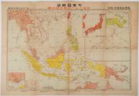
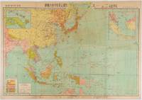
1719176771東京. Tokyo.: 日本放送出版会社. Nihon Hōsō Shuppan Kaisha. Showa 17 1942. Colour folding map scale 1:14500000 55cm x 80cm naval warship photographic illustrations on reverse. The wartime paper is browned and friable but small closed tears along fold lines and edges have been neatly repaired with archival washi on the verso. 79 x 53cm This colour map of Asia and the Pacific was published as a supplement to a magazine Hoso 放送 on January 1942 less than one month after the Pearl Harbor attack by the Japanese Forces. The war had just started but amazingly the map accurately predicted where the fighting would take place throughout the war. An inset map on upper right shows Singapore Borneo Sumatra and Java where battles took place in the area in early 1942. An inset chart on lower left shows various resources and their location including coal tin and iron ore clearly showing that the war was fought over securing resources. On reverse eleven photographic illustrations of war ships from Germany Britain the US and Japan are shown including the Prince of Wales and Enterprise. . 日本放送出版会社. [Nihon Hōsō Shuppan Kaisha]. unknown
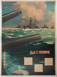
1619176888東京. Tokyo.: 東京日日新聞社. Tōkyō Nichinichi Shinbunsha. Showa 16 1941. Colour poster from a 1941 calendar. 53.5 x 38.5cm small holes at corners central horizontal fold. Some light even browning but overall a striking WWII image from a Japanese calendar. This colour illustrated calendar shows the months of March April and May 1941. The illustration features four Japanese war ships at sea with two naval guns in the foreground. The calendar is titled "Rough Sea on the Pacific Ocean". The implication being military threats are coming from across the Pacific. . 東京日日新聞社. [Tōkyō Nichinichi Shinbunsha]. unknown
1719219230東京. Tokyo.: 日本放送協会. Nihon Hōsō Shuppan Kyōkai. Showa 17 1942. Colour folding map scale 1: 10000000 54.7cm x 79.5cm chronology of building the Greater East Asia Co-Prosperity Sphere on reverse. Some light browning a little darker at folds and reverse washi repairs to folds on reverse. This colour map of Asia and the Pacific published on 30 January 1942—just one month after Japan's attack on Pearl Harbor—offers a striking glimpse into wartime strategy and propaganda. Remarkably despite being produced at the war's outset it accurately anticipated key battlegrounds that would define the conflict. The main map is supplemented by two inset maps: one in the upper right highlighting Japan the Hawaiian Islands and Honolulu and another in the lower left focusing on Singapore with Darwin marked along the lower edge. <br> <br>The reverse side features a revealing chronological chart titled "Building Great East Asia" documenting Japan's military expansion from the 1931 Manchurian Incident through January 1942 as troops advanced across Southeast Asia. Notably two blank rows were intentionally left at the chart's end anticipating future victories to be recorded as the war progressed—a telling detail that underscores the map's dual role as both strategic document and propaganda tool. An interesting map which combines geographical precision with ideological messaging. . 日本放送協会. [Nihon Hōsō Shuppan Kyōkai]. unknown
20192-6139516528Éditions universitaires européennes 2019. Paperback. New. 60 pages. French language. 8.66x5.91x0.14 inches. Éditions universitaires européennes paperback
6138394003.Gpaperback. Good. Access codes and supplements are not guaranteed with used items. May be an ex-library book. paperback
ria9786208561635_inpPaperback. New. New Book; Fast Shipping from UK; Not signed; Not First Edition; N/A paperback
6208561639.Gpaperback. Good. Access codes and supplements are not guaranteed with used items. May be an ex-library book. paperback
4063Omaha Nebraska:: The Railroad. Double-page centerfold color map system map; 48 halftones some tinted; 48 pp. Small folio cherry card stock front embossed with two views and gilt title. Small folio as new with a very narrow band of fading along the bottom edge barely visible. FIRST EDITION. Institutionally fairly common but De Golyer does not appear to have it. [Omaha, Nebraska:: The Railroad,. unknown
192719-12-29-GOOD-52267-JMC. J. Collins General Passenger Agent Union Pacific System 1927-01-01. Paperback. Fair. Small dampstain. Great reading copy. C. J. Collins General Passenger Agent Union Pacific System paperback
1933P2593Used; Very Good. 57-G-29 Union Pacific System 1933 Paperback staple bound. Text is clean and unmarked. Covers have light wear. Book Condition; Very Good . 1933. TRADE PAPERBACK. paperback
192110027Los Angeles: George Starr White 1921. First Edition. Hardcover. Very good. 8vo.283 pp. black cloth over/boards front cover and spine lettered in gilt illustrated with many drawings. Gold lettering on the spine very faded. Faint crease to the approxiametely the first 14 pages. -- Condition. "George Starr White July 13 1866 - November 28 1956 was an American physician chiropractor and inventor of many chromotherapeutic apparatus radionic devices and other types of medical nostrums. By his own accounting White diagnosed nearly a quarter of a million cases and penned over a hundred books. George Starr White hardcover
0266819354.Ghardcover. Good. Access codes and supplements are not guaranteed with used items. May be an ex-library book. hardcover
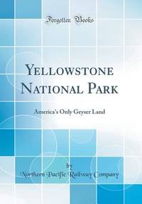
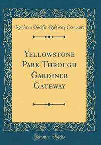
191449010N.P.: Privately printed 1914. 1914. 9" x 8" in color pictorial wrappers folded in half to 60 pp. including cover. Double-column text. Illustrations map itinerary. The purpose of this pamphlet is to provide information about the park for the potential tourist as well as offering the advantages of the Northern Pacific Railways as a means of reaching the park. Offers history of the park and information about it to include its climate when to visit park information park transportation fishing hunting hotels and camps excursions through the park etc. Double-page color map at center entitled "Yellowstone National Park Showing Stage Lines" followed by itineraries pricing and schedules for various park tours. Numerous black and white photographs throughout of various points of interest. Cover page is scraped and rubbed as well as rubbing to spine. Very good. Privately printed, 1914. unknown
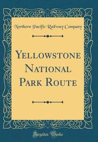
192444000Omaha: The Acorn Press 1924. 1924. 10" x 7" in green pictorial wrappers showing an illustration of a geyser at bottom corner. 40 pp. illustrations maps. General description of Yellowstone Park followed by information on its history the environs of the park its climate the geysers the Great Falls Mt. Washburn the Tower Falls region Mammoth Hot Springs wildlife various forms of transportation to and within the park descriptions of tours within the park as well as pricing etc. Double-page map of Yellowstone Park and area showing routes of park tours in orange trails roads railroads etc. Last page of booklet offers a full-page system map. Black and white photographs throughout to include pictures of scenery wildlife individuals participating in various activities etc. Center two pages disbound pages lightly soiled and with light wear to page edges. Wrappers lightly soiled and with light wear to the extremities. The Acorn Press, 1924. unknown
0265796326.Ghardcover. Good. Access codes and supplements are not guaranteed with used items. May be an ex-library book. hardcover
0265886864.Ghardcover. Good. Access codes and supplements are not guaranteed with used items. May be an ex-library book. hardcover
1396020071.Ghardcover. Good. Access codes and supplements are not guaranteed with used items. May be an ex-library book. hardcover
0266794203.Ghardcover. Good. Access codes and supplements are not guaranteed with used items. May be an ex-library book. hardcover
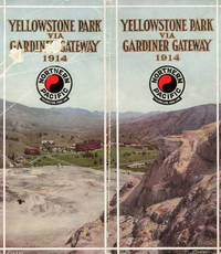
1913019149St. Paul MN: Northern Pacific Railway 1913. Book. Very good- condition. Paperback. First Edition. Oblong octavo 8vo. 40 pages of text. Color paperback binding with quite a bit of soiling and a large crease to the rear wrapper; original string-binding remains intact. Minor water stain visible on top corner. Illustrated with 2 maps. 37 pages contains one or more black-and-white photographs. . Northern Pacific Railway Paperback
0484571257.Ghardcover. Good. Access codes and supplements are not guaranteed with used items. May be an ex-library book. hardcover
133344088X.Gpaperback. Good. Access codes and supplements are not guaranteed with used items. May be an ex-library book. paperback
0265795753.Ghardcover. Good. Access codes and supplements are not guaranteed with used items. May be an ex-library book. hardcover
0265837936.Ghardcover. Good. Access codes and supplements are not guaranteed with used items. May be an ex-library book. hardcover
58-0496San Francisco Calif.: Southern Pacific Company 1918 rev. 1945. Blueline print 24 inches x 47 inches. From Aqua station beyond South San Francisco to 3rd & Townsend Station Visitacion to Daly City. Includes track plans for South San Francisco Visitacion San Francisco Cemetaries. Scale not indicated. San Francisco, Calif.: Southern Pacific Company, 1918, rev. 1945. unknown
56-0433San Francisco Calif.: Southern Pacific Company n.d. Blackline print 15" x 41". Portion of previous map indicating only area of railroad yard. No legend. From Biola Junction and Muscatel to Barton Calwa Tower. Detailed listing of structures and signals inside railroad yard. No scale indicated. San Francisco, Calif.: Southern Pacific Company, [n.d.] unknown