6 260 résultats
22 pages. Plus a full-page sketch map and photographic plates. Original condition with blue wrappers, titles to front, and containing all the ads. This is a complete issue, seldom found in such good and original condition. This is an extensive expedition account of Mr. Terry, an explorer and gold prospector, traveling on a Ford motor car in the little-known portion of Australia, the Northern Territory, from Winston in Western Queensland to Broome on the West Australian coast, containing exceptional details of his adventures. This fascinating account pre-dates the author's book, entitled "Across Unknown Australia," first published in 1926, and is beautifully illustrated with photographs and a sketch route map. Following is Mr. Terry's travel route from Winton to Broom: Winton, Kynuna, McKinlay, Cloncurry, Duchess, Camooweal, Avon Station, Rankin River, Alexandria Station, Alroy Station, Brunette Station, Anthony's Lagoon, Monmoonah Water Hole, Newcastle Waters, Yellow Water Holes, Jump-up, Montijinny Out-station, Pigeon Holes Out-station, Wave Hill Station, Inverway Station, Soakage Creek Station, Flora Valley Station, Hall's Creek, Mulla-Bulla Station, Booty's Selection, Margaret River Station, Cox's Selection, Fitzroy Crossing, Debry, Broome.
6 pages, including 3 sketch maps. Plus a few photographic plates. Original condition with blue wrappers, titles to front, and containing all the ads. Some crease to pages and wrappers, otherwise this is a complete issue, seldom found in such good and original condition. Michael Terry, known as "The Last of the Australian Explorers" was an explorer and gold prospector, and the leader of fourteen inland Australia expeditions between 1923 and 1935, mainly working for Adelaide mining companies seeking minerals. This is a succinct account of his prospecting expedition to the Petermann and Tomkinson Ranges in Central Austraila, in which he traversed approximately 3000 miles in the lands west of the Overland Telegraph Line in search of useful minerals including gold. Terry did not find any significant mineral, but found great quality pastoral land in and adjacent to the Tomkinson, Mann, and western portion of the Musgrave Ranges.
24 pages, including a full-page sketch map. Plus photographic plates. Original condition with blue wrappers, titles to front, and containing all the ads. This is a complete issue, seldom found in such good and original condition. Michael Terry, known as "The Last of the Australian Explorers" was an explorer and gold prospector, and the leader of fourteen inland Australia expeditions between 1923 and 1935, mainly working for Adelaide mining companies seeking minerals. This is his extensive expedition account traversing approximately 2000 miles on caterpillar-track trucks with a team of mineralogists, topographers and botanists, for four months, from Darwin in the Northern Territory to Broome, Western Australia This fascinating account pre-dates the author's book, entitled "Across Unknown Australia," first published in 1926, and is beautifully illustrated with photographs and a full-page sketch route map through North-East Australia.
60409 ½ inches 24 cm. diameter; 21 inches 53 cm. total height. Single pedestal globe with horizon ring armature & meridian all of wood wear and staining on meridian at point where fits into stand some chipping at extremities else fine; globe with vibrant original color and clear sharp patina; some abrasion & losses mostly in lower and upper extremities; overall very good plus condition.<br /><br />An attractive very capably executed table or desk globe in the distinctive style of the Delamarche firm <i>"the most successful French entrepreneurs in maps and globes"</i> Dekker/ van der Krogt. This was an original work by the son Felix who succeeded his father in the management of the firm in 1817. The globe is geographically up-to-date notably in the South Pacific and Alaska with information from then recent Russian voyages such as Krusenstern's. Related to this at the time the globe appeared and reflected on it Europeans were beginning to differentiate between various regions of the Pacific. These were based on a better understanding of cultural and other differences between the peoples of various areas encountered on these recent voyages. For example in 1831 the French explorer Dumont d'Urville proposed the use of the terms "Micronesia" and "Melanesia" for various parts of the Pacific as distinguished from Polynesia. Printed dashed lines on this globe labeled "Division Oceanique" roughly approximate the three eventually accepted divisions of what is referred to as the South Pacific though the regions are not named on the globe. Delamarche also clearly identifies on the globe the more traditional divisions of the Pacific between "Grand Ocean Boreal" "Grand Ocean Equinoxial" and "Grand Ocean Austral."<br /><br />The Delamarche firm was the first to successfully reach a fairly sizable general market of globe buyers. It accomplished this by reducing the cost of constructing globe stands and other parts while maintaining a high level of quality in the maps of their globes which are cleanly and attractively engraved. Traditional brass meridians were replaced by wooden ones and the horizon rings and armatures supporting the rings were greatly simplified and made from either wood or stiff board. Also the firm generally used simpler single-pedestal stands rather than four-legged designs. Yet as this well-preserved example demonstrates Delamarche's design and materials proved to be very durable.<br /><br />Charles-Francois Delamarche 1740-1817 the founder of the family firm was the successor of the great map and globe-making family the Robert De Vaugondys as is cited in the title of this globe. Delamarche in fact seemed to have cornered the globe market in France by also incorporating the stocks of Jean Fortin and Jean Lattre. Delamarche's son Felix took over the firm upon his father's death and managed it until 1848 when Gosselin succeeded him. The firm continued well into the latter 19th century under yet another Delamarche descendent.<br /><br />Dekker/ Van der Krogt <i>Globes from the Western World</i> pp. 63 74; Dekker E. <i>Globes at Greenwich</i> pp. 321-25; Suarez T. <i>Early Mapping of the Pacific</i> p. 25. books
60409 ½ inches 24 cm. diameter; 21 inches 53 cm. total height. Single pedestal globe with horizon ring armature & meridian all of wood wear and staining on meridian at point where fits into stand some chipping at extremities else fine; globe with vibrant original color and clear sharp patina; some abrasion & losses mostly in lower and upper extremities; overall very good plus condition.<br /><br />An attractive very capably executed table or desk globe in the distinctive style of the Delamarche firm <i>"the most successful French entrepreneurs in maps and globes"</i> Dekker/ van der Krogt. This was an original work by the son Felix who succeeded his father in the management of the firm in 1817. The globe is geographically up-to-date notably in the South Pacific and Alaska with information from then recent Russian voyages such as Krusenstern's. Related to this at the time the globe appeared and reflected on it Europeans were beginning to differentiate between various regions of the Pacific. These were based on a better understanding of cultural and other differences between the peoples of various areas encountered on these recent voyages. For example in 1831 the French explorer Dumont d'Urville proposed the use of the terms "Micronesia" and "Melanesia" for various parts of the Pacific as distinguished from Polynesia. Printed dashed lines on this globe labeled "Division Oceanique" roughly approximate the three eventually accepted divisions of what is referred to as the South Pacific though the regions are not named on the globe. Delamarche also clearly identifies on the globe the more traditional divisions of the Pacific between "Grand Ocean Boreal" "Grand Ocean Equinoxial" and "Grand Ocean Austral."<br /><br />The Delamarche firm was the first to successfully reach a fairly sizable general market of globe buyers. It accomplished this by reducing the cost of constructing globe stands and other parts while maintaining a high level of quality in the maps of their globes which are cleanly and attractively engraved. Traditional brass meridians were replaced by wooden ones and the horizon rings and armatures supporting the rings were greatly simplified and made from either wood or stiff board. Also the firm generally used simpler single-pedestal stands rather than four-legged designs. Yet as this well-preserved example demonstrates Delamarche's design and materials proved to be very durable.<br /><br />Charles-Francois Delamarche 1740-1817 the founder of the family firm was the successor of the great map and globe-making family the Robert De Vaugondys as is cited in the title of this globe. Delamarche in fact seemed to have cornered the globe market in France by also incorporating the stocks of Jean Fortin and Jean Lattre. Delamarche's son Felix took over the firm upon his father's death and managed it until 1848 when Gosselin succeeded him. The firm continued well into the latter 19th century under yet another Delamarche descendent.<br /><br />Dekker/ Van der Krogt <i>Globes from the Western World</i> pp. 63 74; Dekker E. <i>Globes at Greenwich</i> pp. 321-25; Suarez T. <i>Early Mapping of the Pacific</i> p. 25.
288 pages. Features: One War to Go - The Coming Fight with Japan; U.S. Meat in This War - how boneless beaf solved the logistics of meat for the first time; Philips of Eindhoven - The big Dutch electrical company, in the U.S. to stay, shows no signs of changing its cartel tactics; The New Transport Planes - Consolidated Vultee's Clipper - the state of the art, how we got here, and what's in the future; The Bogey of Economic Maturity - Washington spenders claim capitallism is moribund; Commander Eugene F. McDonald of Zenith; The Medal - today's heroes are heirs to the great tradition of Pisanello; The Military Police - bully boys in the last war, this time they have won the G.I.'s respect; Battle for the Philippines - the U.S. settled the battle of the Pacific; and more. Many excellent vintage ads in color and black and white, perhaps being the one-page War Loan ad which features photo of Admiral Hirohito on horse, with inset photo of Admiral Halsey who has expressed his desire to ride the Emperor's horse, Shirayuki. Another great color ad by International Harvester shows U.S. troops storming Pacific beach with title "Till The Japs Say Uncle"; Somewhat above-average external wear. Unmarked. Spine lean. A worthy vintage copy of this sensational WWII-era issue. Book
73380Paris, éd., Eugène Figuière, 1932, EDITION ORIGINALE, in-12, br., couv. ill. en rouge avec texte en rouge et noir éd., 192 pp., non coupé, Bon livre sur l'histoire de Tahiti. RARE Très bon état
2003EL305072003 Butterflies, 36, 2003 : In-8 Raisin, Broché. tiré-à-part, pp. 45-49, 10 figures en couleurs et 1 carte in-texte, Très bon état, Couv. fraîche, Dos impeccable, Intérieur frais.
4to [34 x 25 cm]; 256 pp, hundreds of photos. original simulated leather, pictorial gilt kangaroo and gilt lettering on cover, rubbed at spine ends, very good. A picture of this book is available upon request by email. Subtitled, memorabilia for U. S. Forces in Australia, it consists of mainly photos of scenes, people, nature, cities, native peoples and all aspects of the region with brief descriptions.
1877MM456731877 34 p., printed wrappers. Ex libraries Linnean Society NSW and H. Dijkstra (with their stamps).
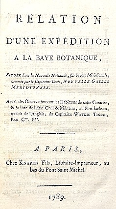
178915722Knapen fils Paris 1789 1 vol. In-8 de 8 ff.n.ch. 136 pp., pleine basane racinée de l'époque, dos lisse orné (frotté), pièce de titre, tranches jaspées (coiffe supérieure arasée, une charnière fragile).
1333821727.Gpaperback. Good. Access codes and supplements are not guaranteed with used items. May be an ex-library book. paperback
1964VF250701964 263 p., 33 figs, num. pls (depicting 68 fishes), 1 map, new green cloth. Library stamps (Zoological Museum Amsterdam). Records of the American-Australian Scientific Expedition to Arnhem Land. Scarce.
132 pages. Short Stories: Compromise Courtship; Doctor's Gamble; Hand-Me-Down Bride; The Meanest Kid in Town. Articles: Our Ordeal over the Pacific - Maj. Samuel W. Tyson nurses a crippled C-97 transport 1000 miles ; Theyd Rather Dance Than Eat - the Roseland at Broadway; The Woes of West Coast Football - the scandal-ridden Pacific Coast Conference; Out of My Past (part 4 of 5) - George Raft; The Negro in the North (part 1 of 2) - predictions of desegregation-related social upheaval; Struggle for Power In Indonesia; We Run a Nursing Home. Serials: Trouble at Midas Creek (part 2 of 7); Violent City (conclusion). Ads: Kelvinator and GE appliances; Chanse & Sanborn coffee; United Aircraft Corporation;Campbell's Soup; Euclid excavating equipment; GE TVs; Arvin transistor radios and radiant heaters; Wheeling Metal Products; Nice 7-Up ad features young drummer; Lucky Strike (back cover). Average wear. Unmarked. A sound vintage copy. Magazine
1985EH408881985 vi, 381 p., 1 map, cloth. Library stamps, else very good copy.
8vo [22 x 14 cm; xxx, [ii], 594 pp, 5 maps (as called for) including folding, glossary of plants and birds, bibliography, index. original cloth, gilt spine title lettering, library withdrawal stamp on title page, but no other library markings, interior clean and unmarked, cover unmarked with minor wear, overall very good, sound copy. A picture of this book is available upon request A detailed and scholarly work covering each explorer/traveller with separate chapters, including Colenso, Selwyn, Charles Abraham, John Johnson, Heaphy, Brunner, Thomson, Percy Smith, A. J. Barrington, Herbert Meade, and others.
64590Coll. "Etonnants Voyageurs", Paris, Seghers, 1983, Première Edition, in-8, br., couv. photo en noir éd., 256 pp., nb. photos en noir, Bibliographie, Table des matières, Les principaux voyages qu'a effectué Victor Segalen : le Pacifique et la Chine. Très bonne biographie sur la partie la plus importante et la plus marquante de sa vie et de l'élaboration de son œuvre. Très bon état
3 pages, plus 3 plates, one showing the portrait illustrations of Drake and Cavendish, and two showing the draft. Original condition with blue wrappers, titles to front, and containing all the ads. This is a complete issue, seldom found in such good and original condition. This is an enlightening succinct account of tremendous historical importance, the most significant discovery of two documents found in the British Museum, revealing the actual draft project and other correspondence concerning Drake's secret voyage, which existed prior to the dramatic expedition. Previous to this report, all discussions as to what plan and instructions Drake carried with him when he finally sailed for Magellan's strait in December of 1577 had been based upon after the events: upon the course which he actually travelled, narratives written and dispositions made when he returned a national hero. The first document found, consisting of three pages, two of which are reproduced in facsimile in this article, is the draft plan of the voyage which subsequently took shape as a circumnavigation of the world. This document gives a list of the promoters of the voyage, the Lord High Admiral (the Earl of Lincoln), Leicester, Walsingham, Hatton, Sir William Winter, George Winter, John Hawkins and Francis Drake. The second document is the report made by John Winter on the 2nd of June, 1579, the day he reached England, nearly eight months after losing sight of Drake in the South Sea, the second page of which contains the plan to be followed, revealing that the ships are to go and return by Magellan's strait, that unknown shores not in the possession of and Christain Prince are to be visited, and that, if it seems to be advisable to Francis Drake, the voyage is to be extended to 30 degrees, while its duration is to be thirteen months. Drake's circumnavigation of the globe began amidst political and religious upheaval in Europe, in 1577. The voyage was so far ahead of its time that another 200 years would pass before the eighteenth-century explorers of record reached the northwest coast of North America. Drake's secret voyage, the exploration of the Pacific Northwest in hopes of finding the fabled Northwest Passage to eastern trade routes, and to establish a British colony in the New World, was hidden under a "cloak of secrecy" due to Drake's complicated relationship with Queen Elizabeth and England's precarious political situation with Spain. One of 16th-century England's most daring adventurers, Drake sailed all the way to Alaska, much farther than anyone had envisioned, thereby rewriting the history of exploration in North America. Surviving the dangers of mutiny, the lack of knowledge about wind and current, and the arduous physical challenges faced every day, Drake earns his reputation as "one of the greatest mariners that sail[ed] the seas, both as a navigator and as a commander," feared by his enemies for the "alarming scope of his success." Together with Hondius's portraits of the first two English circumnavigators, Sir Francis Drake and Sir Thomas Cavendish on one plate and a page of explanatory text. Jodocus Hondius (1563-1612), was a Dutch engraver, and cartographer. He is best known for his early maps of the New World and Europe, for re-establishing the reputation of the work of Gerard Mercator, and for his portraits of Francis Drake. He helped establish Amsterdam as the center of cartography in Europe in the 17th century.
8vo., First Edition thus, with frontispiece, plates and endpaper maps; blue cloth, gilt back, a very good, bright, clean copy. Published a year after the Australian edition.
2004LFA-126725976Un ouvrage de 173 pages, format 140 x 225 mm, illustré, relié cartonnage sous jaquette couleurs, publié en 2004, bon état
MAR344M12Oh Éditions, 2003. In-8, broché, couverture illustrée, 173 pages. Couverture et tranche légèrement jaunies. Intérieur très bon. Coins légèrement émoussés. Bon exemplaire.
viii + 216pp. avec qqs. illustrations, dos peu reparé, bon état, H30249
viii + 216pp. avec qqs. illustrations, reliure cart., dos en cuir noir avec titre doré, feuilles de garde marbrées, texte frais, bon état, H103033
1890H30249Bruges, Desclée, de Brouwer 1890 viii + 216pp. avec qqs. illustrations, dos peu reparé, bon état, H30249
1890H103033Bruges, Desclée, de Brouwer 1890 viii + 216pp. avec qqs. illustrations, reliure cart., dos en cuir noir avec titre doré, feuilles de garde marbrées, texte frais, bon état, H103033