Zancon PietroMareMagnum

18 204 résultats
RARITA’ CARTOGRAFICA Sconosciuta piccola carta geografica con imprint di Giacomo Zatta e data 1794, appartenente a un non documentato atlante in miniatura dal titolo “Atlante tascabile per le dame”, suddiviso in tre tomi, stampati “IN VENETIA Presso G. Zatta”, senza data ma circa 1795. Si tratta di carte da visita – con un apposito spazio bianco dove apporre il proprio nome – dove compare l’imprint o di Pietro Zancon (accompagnato dalla data 1794) o di Giacomo Zatta (con data 1794 o 1795), che, come si legge sul frontespizio, risulta l’editore dell’opera. Possiamo ipotizzare che la serie, iniziata da Zancon fu poi terminata dallo Zatta. Sulla carta dell’Italia – presumibilmente la prima tavola dell’opera – compare stampato il nome di Chiara Minelli Rota, nobildonna veneziana che sposò Antonio Rota nel 1794; tutte le restanti 65 carte recano lo spazio bianco privo di nome. In precedenza, le carte erano note solo attraverso una serie, priva di imprint editoriale, venduta 21 anni fa (1999) dall’Antiquariaat Haas di Bedburg Hau; parlando con Stephan Haas, la serie, priva di titolo e dati editoriali si componeva di 70 mappe. Le carte furono vendute separatamente sotto il nome di G. Bonatti, firma dell’incisore che si trova nella carta della Francia. In seguito, le tavole furono attribuite a Pietro Zaricen da Geoffrey King (cfr. Miniature Antique Maps, p. 181). Il nome dello Zaricen viene dedotto dalla carta della contea del Roussillon, che reca l’iscrizione “Venezia 1794 App.o P. Zancon”, letto erroneamente come Zaricen. Lajos Szantai include la carta dell’Ungheria nella sua cartobibliografia, traducendo il nome dell’autore in Zancen (cfr. Atlas Hungaricus 1528-1850). Sempre King, che non menziona nessuna carta firmata da Zatta, sostiene che “About the turn of the century a signed card of the first edition, with a map of the province of Roussillon in the south of France, was seen at an Ephemera Society Fair in London”. Questo esemplare sembrerebbe oggi quello conservato alla Yale University Library [1978 351], che lo descrive composto da 70 carte geografiche. Non sappiamo se sia il numero totale delle mappe, e l’assenza di un indice o dell’elenco non consente di stabilire l’esatto numero delle carte che lo compongono. http://hdl.handle.net/10079/bibid/3611852Confrontando le carte erroneamente attribuite allo Zaricen ci si accorge che la lastra è abrasa in corrispondenza della firma di Zancon o Zatta. Molto scarse sono le notizie sulle carte che possiamo ora definire “ex Zaricen”. Jason Hubbard nella sua bibliografia recente sulle carte del Giappone raffigura la carta priva dell’imprint “App.o G. Zatta” attribuendola - sulla base delle informazioni bibliografiche finora note – a Giuseppe Bonatti e Pietro Zaricen: “This is one of the 70-odd geographical cards, printed on one side only, acquired by the Haas brothers in 1999. The cards cover countries around the world and include detailed map of Italian provinces. The card with the map of France carries the inscription: G. Bonatti fece; and it is presumed that Bonatti engraved all of them although this is questioned by King” (cfr. J. Hubbard, Japoniae Insulae, n. 124). Il nostro esemplare della carta della Francia, che reca l’imprint “Venezia 1794, App.o P. Zancon” reca in basso a destra la firma di Bonatti sopra menzionata. Dunque, l’unica differenza tra questa serie di sconosciute carte sembra essere la presenza degli imprint editoriali di Zancon e Zatta, accompagnati dalla data 1794 o 1795. Giuseppe Bonatti è menzionato da V. Valerio nella qualità di incisore cresciuto alla scuola Remondini di Bassano, autore di alcune carte per l’atlante di Pazzini Carli (Siena, 1788-1800) e per l’Atlante Geografico di Carlo Antonio Barbiellini (Milano, 1807). Dal 1809 in poi lavorò come incisore per il Deposito della Guerra di Milano (cfr. V. Valerio, Cartografi Veneti, p. 153). Pietro Zancon era, assieme ... A GREAT RARITY Unknown small map with imprint by Giacomo Zatta and date 1794, belonging to an undocumented miniature atlas entitled “Atlante tascabile per le dame” (Pocket Atlas for ladies), divided into three volumes, printed "IN VENETIA Presso G. Zatta", undated but about 1795. A rare set of visiting cards published in Italy features pretty little maps of all parts of the world - with a special white space where to put your name - where the imprint appears or of Pietro Zancon (accompanied by the date 1794) or Giacomo Zatta (with the date 1794 or 1795), who, as can be read on the title page, is the publisher of the whole Atlas. We can speculate that the series, started by Zancon was later terminated by Zatta. On the map of Italy is printed - presumably the first map of the work - the name of Chiara Minelli Rota, Venetian noblewoman who married Antonio Rota in 1794; all remaining 65 maps bear the blank space without names. Previously, the maps were known only through a series, without editorial imprint, sold 21 years ago (1999) by the Antiquariaat Haas of Bedburg Hau; speaking with Stephan Haas, the series, without title and printing details, consisted of 70 maps. The maps were sold separately under the name of G. Bonatti, the engraver's signature found on the map of France. Later, the plates were attributed to Pietro Zaricen by Geoffrey King (see Miniature Antique Maps, p. 181). The name of Zaricen is derived from the Roussillon county map, which bears the inscription "Venice 1794 App.o P. Zancon", incorrectly read as Zaricen. Lajos Szantai includes the map of Hungary in his cartobibliography, translating the author's name into Zancen (see Atlas Hungaricus 1528-1850). Always King, who does not mention any map signed by Zatta, said: "About the turn of the century a signed card of the first edition, with a map of the province of Roussillon in the south of France, was seen at an Ephemera Society Fair in London ". This copy would seem to be the one preserved in the Yale University Library [call number 1978 351], which describes it as being composed of 70 maps. We do not know if it is the total number of maps, and the absence of an index or list does not allow to establish the exact number of maps. http://hdl.handle.net/10079/bibid/3611852 Comparing the maps erroneously attributed to Zaricen one realizes that the plate is erased in correspondence with the signature of Zancon or Zatta. There are very little information on the maps, that we can now define as "ex Zaricen". Jason Hubbard in his recent bibliography on the maps of Japan depicts the map without the imprint "App.o G. Zatta" attributing it - on the basis of the bibliographic information so far known - to Giuseppe Bonatti and Pietro Zaricen: “This is one of the 70-odd geographical cards, printed on one side only, acquired by the Haas brothers in 1999. The cards cover countries around the world and include detailed map of Italian provinces. The card with the map of France carries the inscription: G. Bonatti fece; and it is presumed that Bonatti engraved all of them although this is questioned by King” (cf. J. Hubbard, Japoniae Insulae, n. 124). Our copy of the map of France, which bears the imprint "Venice 1794, App.o P. Zancon", also shows the signature of Bonatti mentioned at the bottom right. Therefore, the only difference between this series of unknown maps seems to be the presence of the addresses of Zancon and Zatta, accompanied by the date 1794 or 1795. Giuseppe Bonatti is mentioned by V. Valerio as an engraver raised at the Remondini school in Bassano, author of some maps for the atlas of Pazzini Carli (Siena, 1788-1800) and for the geographical atlas of Carlo Antonio Barbiellini (Milan, 1807). From 1809 onwards he worked as an engraver for the Milan Deposito della Guerra (see V. Valerio, Cartografi Veneti, p. 153). Pietro Zancon was, together with the most famous brother Gaetano, a native engraver of Bassano del Grappa, who grew up at the Remondini prin...
Norimbergue, (hacia 1730), mapa montado sobre cartulina, de 49,5 x 58,5 cm., en colores de época, con bella cartela con figuras alegóricas.
pp. [4], 415, [1]. Small age and damp stains to the first and last 40 leaves or so. Wide margined. Large 4to. 300mm. All edges gold gilt. Early plain full vellum binding. Marbled endpapers. Hand lettered ownership of: J.M Hicks, Winton, September 1910. Sole quarto printing of the Greek New Testament using Baskerville type (i.e., Greek type that Baskerville designed and cut himself). The text follows the 1707 edition by John Mill (1645-1707), with seven variations. This quarto edition was limited to 500 copies, and is much scarcer than the 8vo edition issued around the same time. Gaskell - Add. 1; Darlow & Moule 4755. John Baskerville (1706-1775) was the greatest printer of his era. Born in Wolverley, Hereford - Worcester, England, he became a writing master in Birmingham. He also carried on a successful japanning (varnishing) business there. In about 1750 he began to make experiments in letter founding, and produced the wonderful series of types now named after him. His first book, the Virgil of 1757, was also the first to be printed upon wove paper (manufactured by a process that he invented). In 1758 he became printer to Cambridge University. There he designed other fonts, including his remarkable Greek type. All of his books bear the marks of fine craftsmanship and a refined sense of design.**PRICE JUST REDUCED! RARE. SAFE ADD 1
Very Good Turkish, Ottoman (1500-1928) Original wrappers. Foolscap 8vo. (18 x 12 cm). In Ottoman script (Old Turkish with Arabic letters). 142, [4] p. Some pages are untrimmed and unopened. Foxing on extremities. Overall a good copy. First and only edition of this uncommon first-hand account in verse of the Siege of Scutari, also referred to as the Siege of Shkodër (Shkodra), took place from 28 October 1912 to 23 April 1913 when the army of the Kingdom of Montenegro defeated the forces of the Ottoman Empire and invaded Shkodër, written by Mehmed Fahri Pasha, who served in Serbia as the chief physician of Shkodra by participating in the Balkan Wars (1912-1913). On 8 October 1912, Turkish General Hasan Riza Pasha announced that Montenegro had declared war on the Ottoman Empire in order to erase 600 years of oppression by the "Turkish foot", as the enemy claimed, and that its troops were crossing the border between Montenegro and Albania. Two hours after the news, the Montenegrin troops, as expected, approached Scutari. As much as 70% of the Turkish army in the interior of the Balkans was composed of Muslim Albanians conscripted during the freedom struggle from the Ottoman Empire. Özege 12224.
1800PHO-1932Paris, de l’imprimerie de Guilleminet, 1800, 2 tomes en 1, in-8, xvi-303pp,1f-319pp., demi basane, dos lisse avec pièce de titre rouge et date verte, tranches mouchetées, illustré de 8 planches dont 2 dépliantes, étiquette en page de garde « Marquis de Civille » et ex-libris manuscrit au titre, quelques écritures en marge, frottements aux plats et coupes. A été relié avec, écrit à la plume, la table des volumes ainsi qu’un texte fustigeant le coté révolutionnaire de l’auteur considéré comme un espion de Bonaparte désirant conquérir la Grèce.
Amsterdam, 1620 circa. Dal "Theatrum Orbis Terrarum" incisione in rame all'acquaforte, coloritura d'epoca, cm 36,5 x 51 circa (alla lastra) più margini. Titolo in alto al centro, sottotitolo entro semplice riquadro al centro; nella parte superiore del foglio la grande isola di Creta, nella parte inferiore, in dieci più piccoli riquadri, le isole di Metellino, Cerigo, Scarpanto, Nicsia, Santorini, Milo, Stalimene, Negroponte, Rodus, Scio, testo spagnolo al verso. La prima edizione, con testo latino al verso, è 1584. Esemplare uniformemente ingiallito, con qualche difetto nella parte centrale e bassa del foglio, bella la coloritura e nell'insieme buono lo stato di conservazione.
165940681659 1659 Antoine de Sommaville, Paris, 1659. In-folio plein veau havane, dos à nerfs orné, [1f.] blanc, page de titre aux armes gravées, [7ff.], 549 pages (quatre erreurs de pagination mais le texte est bien complet), [11ff.] de table, 25 pages pour le Parallèle de la Géographie Ancienne & Nouvelle, pour la carte de l'Empire Romain, dressée sur Appian Alexandrin par le Sieur Du Val d'Abbeville, Géographe ordinaire du Roy, 1 carte dépliante rehaussée. Reliure à restaurer, réparation discrète à un pli de la carte, quelques rousseurs.
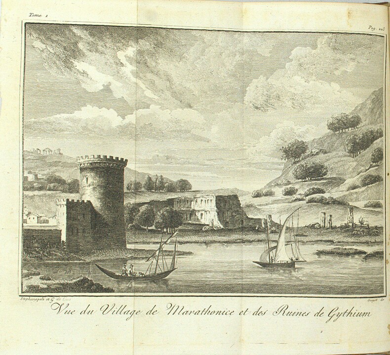
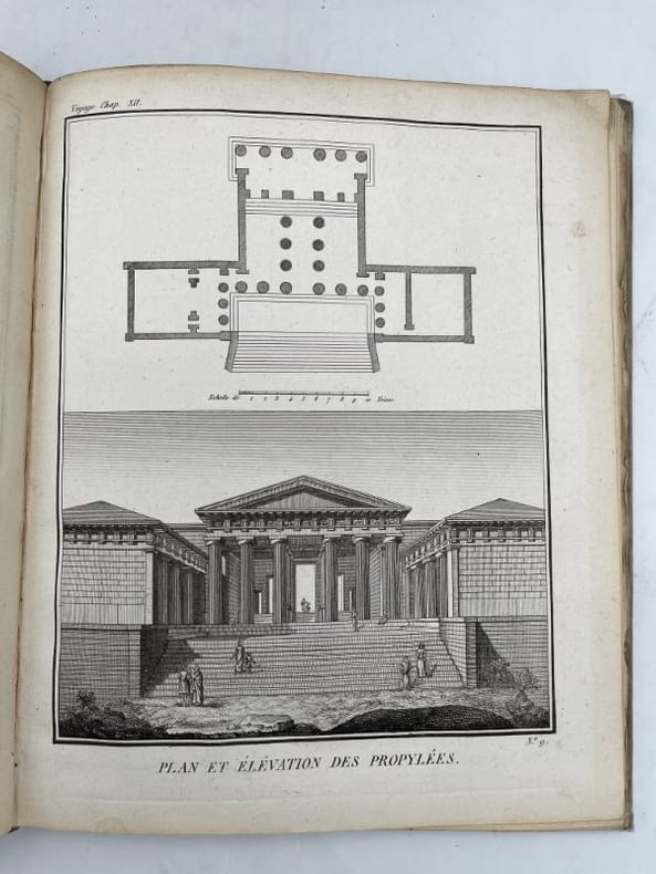
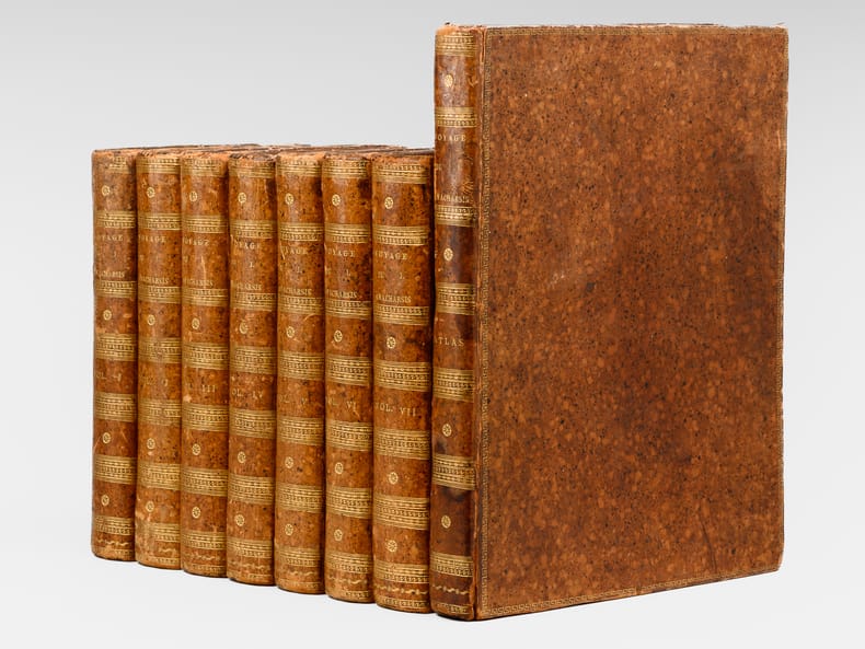
1792177172de Bure A Paris, chez de Bure l'ainé, 1792. 9 volumes In-12 reliés plein veau blond de l'époque, dos à nerfs fleurons dorés, pièces de titre et de tomaison, tranches mouchetées. 1773. Petits accrocs aux coiffes tomes 1, 2, 6. Petti manque en queue destomes 2,4. XXIV + 383 pages et une grande carte dépliante + 396 + 388 + 372 + 408 + 379 + 403 + 420 + 283 pages. Pour l'atlas : Recvueil de cartes géographiques, plans, vues et médialles de l'ancienne Grèce, relatifs au voyage du jeune Anacharsis, précédé d'une analyse critique des cartes. Paris, Garney, 1819. Petit In-4 carré (relioure abuimé avec plat décolidarisé) XIX + 32 planches dépliantes pour la plupart.
179970759Quatrième édition ("Nouvelle Edition" pour l'Atlas) 7 vol. in-8 et 1 vol. d'atlas in-4 reliure de l'époque plein veau moucheté, dos lisses ornés (petits fleurons), grecque dorée en encadrements sur plats, filet sur coupes, De l'Imprimerie de Didot Jeune, Paris, l'an Septième [ 1799-1800], viii-clij-367 pp. avec portrait en frontispice ; VIII-517 pp. ; VIII-496 pp. ; VIII-507 pp. ; VIII-495 pp. ; 3 ff., 454 pp. ; Atlas : 110 pp., avec 39 carte dont carte dépliante ("La Grèce et ses Isles pour le Voyage du Jeune Anacharsis" par J. D. Barbié du Bocage, Août 1788) et vues rehaussées au pastel
1800PHO-2106Paris, Tavernier, An VIII (1800), 3 vol. in-8°, XVI, 407 ; 358 ; 383 pp., Demi veau rouge, dos lisse à décor de rocaille avec auteur,titre et tomaison au dos, rousseurs et petits frottements aux plats, cachet répété. De la bibliothèque de sa SAR le Duc de Gènes avec son étiquette en page de garde et son cachet
179570760Traduite du grec par Pierre-Charles Levesque, 4 vol. in-8 reliure de l'époque plein veau raciné, dos lisse orné, J.B. Gail, P.F. Aubin, Paris, L'An IVme de la République, 1795, 1 f., XXXVIII pp., 1 f., 374 pp. et 1 f. n. ch. ; 1 f., 363 pp. et 1 f. n. ch. ; 1 f., 333 pp. ; 1 f., 337 pp.
8vo., First Edition, with portrait frontispiece and maps in the text; handsomely bound in full navy crushed morocco, sides with gilt frame border, back with raised bands, second and fourth compartments ruled and lettered in gilt, all other compartments tooled in gllt, gilt top, hand-made endpapers, ribbon marker, front panel and fold-ins of dustwrappwrapper mounted on new and separate leaves at front, custom-made slip-case, a most attractive copy ideal as a gift or for presentation. AN ELEGANT COPY OF AN SAS CLASSIC. Well-known account of the author's war service with the SAS, initially in France and Italy and latterly in Greece, Norway and the Middle East. Enser, p.397.
18038426A Paris, Chez Barba, 1803. 4 volumes in-8 de [6]-CIV-444 / [6]-438-[2] / [6]-383 et [6]-XII-466-[2] pages, demi-veau brun à coins, dos lisses ornés de roulettes et filets dorés, étiquettes de titre bordeaux, pastilles de tomaison noires (chiffre arabe), tranches mouchetées. Quelques très légers frottements, quelques rousseurs, belle condition générale.
RARE BILINGUAL LATIN & GERMAN EDITION of Cicero's letters, with translation by the noted 16th-century philologist Stephan Reich. Cicero's letters to and from various public and private figures are considered some of the most reliable sources of information for the people and events surrounding the fall of the Roman Republic. Among the recipients of the letters were such illustrious figures as Caesar, Pompey, Octavian, and Cicero's son Marcus Tullius Cicero Minor. 150x95mm. 409 double pages. Rebound vellum Hardcover. Cover and spine stained and wrinkled. Front cover detached. Spine partly detached from binding. Front cover corners and spine hinges worn. Original title-page pasted on front whitepage. First Title-and dedication pages coming loose from binding. Small hole on first dedication page bottom corner near binding - NO damage to text. Small hole on last page upper corner with damage to only one letter of the text. Pages yellowing, age-stained and wavy. [SUMMARY]: This extremely rare 16th-century bilingual Latin-German edition of Cicero's letters is otherwise in good condition. PLEASE NOTE: This book's cover is very worn, loose or missing. If you'd like, we can send this book to be rebound for an extra charge.
200144915Oxford Clarendon Press. 2001. Hardcover. Very Good in Near Fine dust jacket. Lower corners of Vol 3 a bit bumped. Dustjackets are protected in plastic sleeves.; 3 Volume Complete Set. Sandpiper reprint.; Oxford University Press Academic Monograph Reprints; 1-3; 8vo 8" - 9" tall; 2136 pages; A documented study of the main aspects of Alexandrian life in the Ptolemaic period. An attempt to provide a documented account of selected but associated aspects both of the city as a social unit - its topography its civic organisation and constitutional history its commerce and its cults - and of its achievement in science learning and literature . 0198142781 . Oxford Clarendon Press hardcover
182541623Paris, Picquet, 1825. Plan replié et entoilé de 78 x 50 cm, étiquette "J. Goujon marchand de cartes rue du Bac n°6 à Paris".
In-8 gr., legatura edit. in mz. pergamena, astuccio in tela, pp. 90. "Prima edizione italiana" della sentenze, nella versione originale greca di Giovanni Stobeo, a cura di E. Cetrangolo che ha eseguito la traduzione e scritto le biografie dei saggi. Nota sulla storia dei testi e dei primi caratteri greci, con 2 illustrazioni e 1 calcografia dell'iscrizione marmorea del decreto per Oiniades di Giovanni Mardersteig, che ha pure disegnato gli occhielli e le iscrizioni delfiche, un tempo scolpite nel tempio di Apollo. Cfr. Cat. Mardersteig,195. Edizione in tiratura di 160 esempl. numerati. Il ns., 133, è in perfetto stato.
1807000752Parma Co'Tipi Bodoniani 1807
Paris, chez de Bure, 1789. 7 volumes In-8 reliés demi-basane noire de l'époque, dos lisse très orné de fleurons et filets dorés, plats et gardes marbrés. XVI + 254 + 380 + 362 + 370 + 356 + 326 + 290 pages. Complet de la carte dépliante de "La Grèce et ses iles" par M. Barbier du Bocage. Sans atlas. Infimes petits frottements à la reliure sans aucune gravité, bel exemplaire dans une jolie reliure de l'époque. Le tome 7 contient les tables, elles sont particulièement intéressantes : Table contenant les principales époques de l'histoire gracque depuis la fondation du royaume d'Args jusqu'au règne d'Alexandre. Table contenant les noms de ceux qui se sont dinctingués dans les lettres et dans les arts depuis les temps voisins de la prise de Troie jusqu'au règne d'Alexandre. Les mêmes par ordre alphabétique. Rapport des mesures romaines avec les notres. Rapport du pied romain avec le pied de roi. Rapport du pas romain avec nos toises. Rapport des milles romains avec nos toises. Rapport du pied grec à notre pied de roi. Rapport des stades avec nos toises ainsi qu'avec les milles romains. Rapports des stades avec nos lieues de 2500 toises. Evaluation des monnaies d'Athènes. Rapport des poids grecs avec les notres. Index des auteurs et des éditions cités dans l'ouvrage. Table générale des matières. Une petite mouillure en marge des premiers feuillets du tome 2, sans atteinte de texte. Sinon très bon état.
179021191Paris De BURE Ainé 1790 in-8 plein-veau 7 volumes + 1 volume d'Atlas, reliure plein veau marbré et moucheté blond in-octavo + un atlas demi-veau blond in-quarto (19,7 x 13 cm pour les volumes de texte + 25,5 x 21 cm pour l'Atlas, dos à nerfs décoré "or" et à froid (gilt and blind stamping decoration), titre et tomaison frappés "or" ( gilt title and volume numbering), pièce de titre sur fond havane avec double filets "or" en encadrement, pièce de tomaison sur fond vert foncé avec double filets "or" en encadrement, roulette "or" en place des nerfs avec un filet à froid de part et d'autre des nerfs, entre-nerfs à fleuron "or" dans un encadrement à double filets "or" avec rinceaux "or" aux angles, plats décorés "or", d'une roulette chainette or avec un filet "or" de part et d'autre en encadement, plats trés légèrement épidermés, filet "or" sur les coupes (gilt line on the cuts) avec légers manques de dorure (blurred gilding), toutes tranches lisses jaunes, sans illustrations pour les volumes de texte, l'Atlas contient XLII pages de texte + 31 plans, cartes et illustrations en noir en doubles-planches, (XII + 382) + (2 p. de tables + 568) + (2 p. de tables + 560) + (2 p. de tables + 564) + (2 p. de tables + 543) + (511) + [2 p. de tables + 130 + (2) + CCCXXII + (1)] + (XLII + 31 gravures doubles pages pour l'Atlas) pages, 1790 Paris Chez De BURE Ainé Libraire Editeur,
Romae, apud Antonium Fulgoni, 1785, in-4, cartonatura floscia marmorizzata coeva (leggere mancanze alla carta marmorizzata di rivestimento al dorso), pp. XXIIII, 239, [1], [8], [2], da 243 a 334, [2], l'ultima carta bianca. Con vignetta sul front., testate figurate e 8 tavv. f.t. in fine (contenenti 28 vignette) il tutto inciso in rame. Completo anche del fascicolo *4, (Monumenta nekrologika) recante 8 pagine non numerate e inserito fra i fascicoli Gg4 e Hh4. Bell'esemplare, a pieni margini.
1572LBW-1446[Venise, 1572]. 168 x 222 mm.
1572LBW-1435[Venise, 1572]. 205 x 154 mm.
1784HI291Paris, Alexandre Jombert, 1784,1785,1786. 2 vol. in-4o, 2ff.n.ch., 32 pages et 98 planches et 1f.n.ch., 40 pages et 95 planches. 2 ff.n.ch., 40 p. et 98 planches, 1ff, 40 p. et 60 planches, toutes planches etant hors-texte. Rel. pleine veau contemp. avec usures, 1er plat avec un bout abime, 2e mors decole, dos a nerfs, p. de titres maroquin, marges de 2ff. restaurees, qq pages un peu brunies, tranches coloriees. Edition complete.
ESOPO. Les fables d'Esope, avec cent vingtrois figures d'après Barlow. Collection de gravures piquantes et d'apologues ingenieux pour l'amusement et l'istriction de la jeunesse. A' Paris, chez Tardieu, an X 1802. Album in 16mo; cm.12x20. Due tomi in un volume; pp. XVI,95; cc.2n.nn., 149. Due antiporte e 121 rami. Legatura in mezza pelle, dorso con titolo e fregi in oro ed a secco. Bruniture. Le composizioni che illustrano le favole sono di una finezza e sensibilità d'interpretazione molto significativa. Secondo Brunet I, 102 "les figures de Barlow ont le mérite de répresenter les animaux d’une manière exacte".