1 660 résultats
196738237Maplewood NJ: Hammond Incorporated. As New. 1967. Hardcover. FREE UPGRADE to Courier/Priority Shipping Upon Request IN STOCK AND IMMEDIATELY AVAILABLE FOR SHIPMENT - TEXT PRISTINE Pages tight to spine -- with a bonus offer-- . Hammond Incorporated hardcover
2015114822Acanthus Press. New. 2015. Hardcover. 0926494910 . FREE UPGRADE to Courier/Priority Shipping Upon Request - IN STOCK AND IMMEDIATELY AVAILABLE FOR SHIPMENT - IN STOCK AND IMMEDIATELY AVAILABLE FOR SHIPMENT - Flawless copy brand new pristine never opened - -- with a bonus offer-- . Acanthus Press hardcover

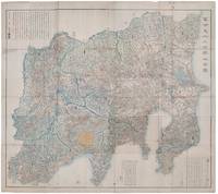
1418159850Shūseidō 衆星堂. Reprint. Tenpō 14 1843. Large folding handcoloured map of the thirteen provinces from which Mt. Fuji can be viewed. 159 x 178cm. Folds into paper covered card covers measuring 40 x 24cm. Title label upper cover. A little browning along folds occasional spotting and soiling. A little worming causing approximately 1cm of loss in places. Two chops in lower section. A very striking and attractive map. This very large handsome map is a detailed map of the thirteen provinces from which one can see Mt. Fuji. Provinces shown are the eight provinces of the Kantō region Sagami 相模 Musashi 武蔵 Kazusa 上総 Shimofusa 下総 Awa 安房 Kōzuke 上野 Shimotsuke 下野 and Hitachi 常陸 and five other provinces Izu 伊豆 Suruga 駿河 Tōtōmi 遠江 Kai 甲斐 and Shinano 信濃. The map offers a large amount of detailed information such as province and county borders rivers high ways post towns checkpoints villages and scenic spots. <br> <br>The cartographer Akiyama Einen or Nagatoshi 秋山永年 came from Edo and the editor Funakoshi Seizō 船越清蔵 studio name: Shugu 守愚 1805-62 a Confucian scholar from Nagato Province now the western half of present-day Yamaguchi Prefecture. A dedication by Funahashi Akira 舟橋徴 is dated 1843. . Shūseidō 衆星堂 unknown
26975'Published by Survey Directorate G.H.Q. Paiforce 1944. All one page 20 x 33cms some stained but texts clear and complate. 1. Index map of Iraq and Iran for a 1:100000 scale survey series produced by the British military command PAIFORCE during World War II. All 20 x 32.5cm a couple sl. stained mainly good condition.1.Four Index maps of Iraq and Iran ¼ series I.D.R./X.D.R./G.S.G.S. 9002 3919 nos. 1-42.Index map of Iraq and Iran for a 1:100000 scale survey series produced by the British military command PAIFORCE during World War II. Index Map of 'Irq rn 1:100000 Series I.D.R. 9003'.3.Four Index Maps of places/areas of IRAN:a. Ahwaz 1:10000 series 1D MISC/563 to 573 stamped 11 June 1944b. Askaran and Sanandaj N.W. 1:25000 series …9005 stamped 25 June 1944c. Gach-I-Sar 1:50000 series stamped 11 June 1944d. Khurramshahr Abandan 1:12500 series4.Six Index Maps of places/areas of IRAQ all 1:25000 series ID 9005:a. Ba'qubab. Faidahc. Haffad. Hindiyae. Falluja f. MoselNo reference to other copies yet found. 'Published by Survey Directorate, G.H.Q. Paiforce [1944] unknown
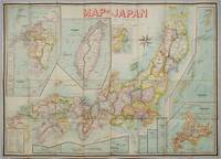
1906197908Kobe Japan.: Fuku-In-Kwan. 1906. Printed colour folding map on two conjoined sheets laid down 73.8 x 10⁵ cms foxing on verso not affecting map single pinhole in each corner scant spotting small fold splits no loss a few soft fold creases but in good condition. Very rare striking map of Japan published for the Western market. <br> <br>Created under the direction of Takachika Okishio featuring 10 inset maps: Chishima Kurile Islands Hokushu Hokkaido Ogasawara-Jima Bonin Islands Hachijo-Shima Ioshima Okinawa Saki-Shima Kyushu Saikaido Taiwan Formosa and Eastern Asia. The insets of Taiwan and Kyushu are the largest and centrally positioned. A Glossary and Explanation of Signs is printed at the foot of the map which list Towns Railway Stations Boundaries of Prefectures Notable Places Hot Springs Water-falls rapids Volcanoes Light-Houses Gold Silver and Coal-Oil fields. The Japanese Government Railway series of Travellers' Maps of Japan appear to have been modelled after this design. . Fuku-In-Kwan. unknown
193461915Chicago IL: Published by A.J. Nystryom & Co. Maps Globes Charts 1934. Seven large linen-backed colour lithograph maps sized from 43.5 x 72 in. to 51.5 x 60 in. all mounted on their original spring-loaded rollers wooden pull dowel & metal ring pull some creasing minor edgewear creasing soot soiling to the lower margin averaging about 6-7 in. due to exposure when rolled “Europe†and “United States†with faint tidemark & discoloration at left margin some minor creasing wear all preserved in the original A.J. Nystrom quarter-sawn oak wall bracket sized 58.5 x 15.25 x 3.25 in. all pull-down maps firmly secured in their steel brackets preserving 6 of the 7 original labels on the edge of the pull-down dowels still a VG- set of maps in their original configuration. First editions thus of this complete and exceptional example of the Atwood/A.J. Nystrom Regional-Political Series Map Case reflecting the many geographical and political changes between World War I and World War II. Such changes are reflected in the appearance of Manchoukuo the Japanese controlled rump state established in Manchuria in 1932 by the Japanese Empire and also depicting Korea still as Chosen. The Europe map depicts the East Prussia still controlled by the Weimar Republic and then after Hitler ascended to power; while Africa still retains much of the colonial powers as shown in the Belgian Congo Anglo-Egyptian Sudan French Equatorial Africa and even Beuchuanaland. The Australia and the Far East Map clearly defines the Japanese United States British & Australian mandates across the South Pacific. Atwood 1872-1949 was a noted geographer and educator who was a member of both the New Jersey and Wisconsin Geological Surveys served in the US Geological Survey served as professor of Physiography at Harvard and later from 1920-1946 when he produced these maps was President of Clark University and Head of its School of Geography. No similar complete sets located in Worldcat. Published by A.J. Nystryom & Co., Maps, Globes, Charts, unknown
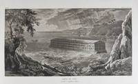
183318856Milano: Fortunato Stella e Figli 1833. First Italian edition. Hardcover. f to vg. Oblong folio 12 6/8 x 18 1/2". 1 leaf Title 38 leaves Plates 1 leaf List of content. Original half morocco over burgundy paper covered boards. Gold lettering and tooling on spine. Rare first Italian edition of Paul-Louis-Bernard Drach's atlas volume of his "Sainte Bible de Vence" a series which was originally published in 27 volumes in Paris from 1827 to 1833. The striking 38 engraved plates featured in this atlas are composed of 13 maps by A. R. Fremin and 25 engravings signed by Falkeisen Angelini and Lanzani. The engraved plates have been laid down on beautiful hand-made paper and describe the following: 1. Map of the place of Eden Mesopotamy and Persian Gulf; 2. Noah's Arch construction; 3. Noah's Arch; 4. Map of the land divided among Noah's sons; 5. The Babel Tower; 6. Map of the Land of Canaan; 7. Map of Jews' Pilgrimage; 8. The Jerusalem Sahnedrin; 9. The Temple of Jerusalem plans and sections; 10. The Temple of Jerusalem square plan; 11. Map of ancient Jerusalem; 12. The Temple of Salomon; 13. The Temple's foundations; 14. The East Gate; 15. The Buildings of the Temple; 16. Musical Instruments of the Jews; 17. Hebrew Alphabet; 18. Jew's Vestments and worship's objects; 19. Two Menorah; 20. High Priest's vestments and Golden Menorah; 21. Moses' Tabernacle; 22. The Loaves of Proposition; 23. Plan and section of the Tabernacle; 24. The encampment of the Israelites; 25. Map of the Holy Land South; 26. Map of the Holy Land North; 27. Map of Syria; 28.Map of Israel under Salomon; 29. Plan of the House of the Forest of Lebanon; 30. The House of the Forest of Lebanon; 31. The Bronze Sea; 32. The Washings; 33. The Altars of the Holocausts; 34. Map of the Persian Empire; 35. Map of the Land of Canaan according to Ezechiel; 36. Map of Herod's Reign; 37. Zachary's Vision; 38. Map of the travels of Saint Peter and Saint Paul. The plates measure appr. 12 1/2 x 18 1/4" image size appr. : 9 1/2 x 14 6/8". Binding rubbed on covers and along edges. Head and tail of spine chipped. Previous owner's Ex-libris Calvin Bullock on inside of front cover. Minor and sporadic foxing along paper margin not affecting plates. Title and captions in Italian. Binding in overall fair interior in very good plates in near fine to fine condition. About the author: "David Paul Drach aka Paul-Louis-Bernard Drach after his conversion 1791-1865 was a Catholic convert from Judaism and librarian of the College of Propaganda in Rome. Drach received his early education from his father who was a rabbi. After spending some time in various Talmudic schools he became a teacher at Rappoltsweiler though only sixteen years of age. The love of the secular sciences brought him to Paris where he was welcomed by his coreligionists and became tutor in a wealthy Jewish family. His reputation as a teacher brought him Christian pupils; and this may have had some influence on his subsequent conversion; in fact he had always manifested some leaning toward Christianity. Drach had already begun the study of Greek and Latin so as to become acquainted with the Christian doctrines in their original sources. Struck by the accusation of some of the Fathers that the Jews had corrupted the Hebrew text he began a comparative study of the Hebrew and the Septuagint which study he continued in spite of the remonstrances of the president of the Central Consistory. Drach was received into the Catholic faith in 1823 together with his two daughters and his son Paul who afterward became a priest and a distinguished Biblical scholar. In 1827 Drach accepted the position of librarian of the Propaganda in Rome which position he held until the year of his death." From the Jewish Encyclopedia. Fortunato Stella e Figli hardcover
19208575Paris 1920. French naval chart 63 x 91.5 cms black and white with beacons highlighted in yellow insets of Port dAbri the inner harbour at modern day Izmir and two coastal profiles slightly dusty lower margin one or two closed marginal tears blank verso. Engraved in 1866 after British charts by Copeland and Spratt this example of the map was printed in September 1920 during the Greek occupation of the Zone of Smyrna part of the territory awarded to Greece at the expense of the Ottoman Empire by the Allied powers after the Great War. Smyrna became an important base for Greek forces during the resulting Greco-Turkish War of 1919-1922 and in the bloody aftermath of the Greek withdrawal half the city was razed in the Great Fire of Smyrna also known as the Smyrna Catastrophe. Map unknown
1840018232London: Printed and Published By J. Barfield 1840. Book. Very Good. Hardcover. Fourth Edition. Folio 30 x 46cm. "Revised Collated and Considerably Enlarged by John Satchell Esq." Seventy-four double-page engraved genealogical tables and geographical maps all with original hand colouring contemporary . half black morocco gilt with green cloth boards. Binding good with some general wear and rubbing leather chipped with loss to the base of the spine joints rubbed but still strong corners worn. All edges gilt./ Contents clean and tight contemporary ink stain effecting the fore-edges of the first few pages but not affecting text or maps most noticeable to the front end papers with also have a pencil inscription dated 30 November 1935. All maps and charts in very good condition. Notwitstanding wear to the binding a very good copy. Printed and Published By J. Barfield Hardcover
000836379XNew. Brand new and still unused unknown
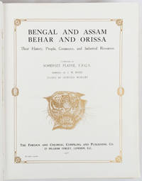
1917214418London and New York.: The Foreign and Colonial Compiling and Publishing Co. 1917. Numerous black and white photographic illustrations. 768pp. Full red morocco binding spine lettered and ruled in gilt in compartments 'Tiger head' emblematical device stamped in gilt on the upper board repeated in gilt on the title page corner ornaments blocked in gilt. All edges gilt marbled endpapers light rubbing to corners but a lavishly produced edition in exceptional condition. 30 x 23.5cm One of a series of publications published with the object of supplying the British public with a picture - complete as far as literary and pictorial effort could make it - of the several different parts of the Empire. in this instance Northern India. . The Foreign and Colonial Compiling and Publishing Co. unknown
GOR006174352Paperback. Very Good. paperback
GOR008482209Paperback. Very Good. paperback
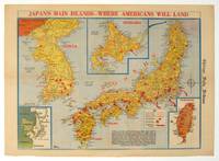
1945208877Chicago.: Chicago Daily Tribune. August1945. Printed colour pictorial map on a single newspaper leaf 37 x 52 cms; 43 x 59.5 cms sheet three inset maps archivally laid down on linen very good condition. Full page map published in the "Chicago Daily Tribune" after the bombing of Hiroshima and Nagasaki prior to occupation by US and Allied forces in September 1945. "This is a new map of the main islands of Japan where American occupational troops will land and establish their military rule." map text The legend notes "Places bombed by U.S. Air Forces with a red circle" and "Cities bombed by Atomic Bomb" with a red star. The main map shows the Japanese islands of Honshu Shikoku and Kyushu with the Korean peninsula. Inset maps show Hokkaido Formosa and a general map of the area. . Chicago Daily Tribune. unknown
GOR004242621Paperback. Very Good. paperback
1790CC136G.G.J. and J. Robinson in Pater-noster Row.: Charles Dilly in the Poultry 1790. Hardcover. Very Good. 101-928pp. Worn original full calf binding with the front board detached but present. LACKING THE REAR BOARD. Illustrated with a correct set of maps by Mr Kitchen. Double page folding maps three with colour BY A YOUNG HAND!. Unlisted chart of the world showing the latest Captain Cook's discoveries bound in at p867. finis. LACKING THE BACK BOARD But a complete text block and plates.215x130mm. 21 plates and the Sphere plate present. A couple of plates hand coloured in outline. An additional CHART OF THE WORLD bound in at the rear. Most maps map two or three creased. A NICE COLLECTION <br/> <br/> Charles Dilly in the Poultry hardcover
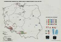
197941929Warszawa Warsaw: Pan´stw. Wydawn. Naukowe 1979. 1st Edition. Original black printed portfolio 8vo. Portfolio of seven large folding maps on on 4 sheets of heavy paper 3 are double sided 1 is singled sided. Primarily black and white with some color. Text in Polish. <br> Title translates to “Nazi camps in Poland 1939 - 1945. An Encyclopaedic Reference Book: Maps." Collection of 7 maps each 84 cm x 60 cm 33 x 24 inches produced by Jan Laskowski at the Main Commission for the Investigation of Nazi Crimes in Poland. The maps comprise Volume II of the work; Volume I is a heavily illustrated 676-page book of the same title which we offer separately. <br> The Seven maps all present are: <br> - Map 1 Single Sided: Hitlerowskie obozy na ziemiach polskich w latach 1939 - 1945. “Nazi camps in Poland in the years 1939 - 1945â€. Showing: concentration and extermination camps sub-camps of concentration camps extermination centers POW camps more important sub-camps working divisions commandos and temporary POW camps penal labor camps major labor camps prisons transit camps & ghettos. <br> - Map 2A: Getta na ziemiach polskich w okresie okupacji hitlerowskiej w latach 1939 - 1945 “Ghettos in Poland during the Nazi occupation in 1939 - 1945â€. <br> - Map 2B: Hitlerowskie obozy przejsciowe na ziemiach polskich w latach 1939 - 1945 “Nazi transit camps in Poland in 1939-1945â€. <br> - Map 3A: Hitlerowskie wiezienia i areszty na ziemiach polskich w latach 1939 - 1945 “Nazi prisons and arrests in Poland in 1939 - 1945â€. <br> - Map 3B: Hitlerowskie obozy pracy na ziemiach polskich w latach 1939 - 1945 “Nazi labor camps in Poland in the years 1939 - 1945â€. <br> - Map 4A: Hitlerowskie obozy jenieckie na ziemiach polskich w latach 1939 - 1945 “Nazi POW camps in Poland in 1939 - 1945â€. <br> - Map 4B: Hitlerowskie obozy koncentracyjne i osrodki zaglady na ziemiach polskich w latach 1939 - 1945 “Nazi concentration camps and extermination centers in Poland in 1939 - 1945â€. <br> Maps 2A & 2B have been described as a “Terrifying pair of maps showing the locations of German POW and internment camps in Poland during World War II highlighting the widespread locations of these establishments. In some parts of the map the information becomes so dense that three inset maps are shown. This map was designed by Jan Laskowski and printed in 1979 as part of a work on the Nazi extermination machine produced by PWN Warsaw a state-owned research-focused publishing house in Poland.<br> The map on the front is particularly interesting for its depiction of symbols used to classify internees in German camps. The uppermost of these depictions shows the combinations that can be made for different types of prisoners of different levels of importance. The armbands that would have been worn by these prisoners is shown as well as the prison uniforms. Other details are also shown. <br> The map lists hundreds of sites run by Nazi operators throughout the country. These include concentration camps death camps transitional camps and ghettos. The map is divided according to Poland's voivodeships with a key in the lower left. Names of cities too long to spell are also provided in the lower left. <br> This map was produced during a point in Poland's history during which it was actively revisiting the period during the Second World War. Leading social scientists devoted their time to trying to gather all the living as well as the recorded history of the events of the Holocaust and related atrocities before this information vanished. Leading these efforts particularly during the 1960s and 1970s was the Glówna Komisja Scigania Zbrodni przeciwko Narodowi Polskiemu known as the Chief Commission for the Prosecution of Crimes against the Polish Nation. They were active in publishing maps both for domestic educational purposes and for international remembrance and diplomatic efforts regarding the Holocaust. Jan Laskowski was a leading cartographer who produced a number of maps in this field. <br> These maps were produced as part of a series of maps that purported to combine to form an atlas of all of Hitler's crimes in Poland. Many of the large wall maps produced during this period could only show a fraction of the crimes or only the atrocities committed in one region. Thus a series of maps was needed to show all the points necessary which this present work contributes to. <br> Polish Reinterpretations of the Holocaust: Studying the effects of German occupation in Poland is a delicate subject. While it is certain that Poland suffered at least as badly as any other European nation during the Second World War reinterpretations of the Holocaust in the country have also been used to satisfy nationalistic tendencies. It has become evident to Western observers in the last several years that there is a strong nationalist movement in Poland that seeks to place blame for the Holocaust solely on the shoulders of non-Polish actors a movement originally fostered under Soviet rule. This movement has gone so far as to limit freedom of speech criminalizing with a three-year sentence the suggestion that Poland or its citizens in any form participated in the murders committed by Nazis. As such the term ‘Polish concentration camps’ has been deemed unacceptable with the government-approved term being ‘concentration camps on Polish territory.’ <br> All lines of evidence show that this map 2A & 2B was produced using the most accurate and impartial historical sources. The language on the map is simple naming only ‘Hitler's Atrocities’ and there is no evidence of a clear anti-German bias. However it is impossible to separate this map one of the most important productions of the remembrance movement during this period from the social situation in which it was produced. Maps like these can easily be converted into propaganda instruments and today's Polish leaders most of whom grew up during Soviet occupation will have formed their understanding of the Holocaust through maps like these. <br> Soviet Censorship: While the content of the map appears to have been produced free from bias the map still had to go through Soviet censorship. Mentioning prisoner of war camps in which primarily Soviet troops were interned would have been a prerequisite condition upon which the publication of the map rested. Further the lack of mention of any Soviet killings or camps requires no explanation….The map unlike many later maps makes no differentiation between the populations who suffered at the various camps. This represents the Soviet agenda that all nations suffered fought and won equally which sought to limit divisions in this post-identity state†Ruderman 2022. <br> SUBJECTS: World War 1939-1945 -- Prisoners and prisons German. -- Concentration camps -- Poland. Guerre mondiale 1939-1945 -- Prisonniers et prisons des Allemands. -- Camps d'internement -- Pologne. Obozy koncentracyjne -- Polska -- 1900-1945. OCLC: 830885973. <br> Light shelf wear to portfolio as expected. All maps in pristine condition with normal folds as issued. Very Good Condition. Complete and dramatic BR5 holo2-147-19-'cc. Warszawa (Warsaw): Pan´stw. Wydawn. Naukowe unknown
185095311J & F. Tallis London Edinburg & Dublin 1850-01-01. Leather. Very Good. 1850 Tallis 6 volumes bound into 2 vols 3/4 leather over marbleized boards. 7 hand colored maps 56 plates ownership ink to flyleafs and book dealership pencil. Tight bindings text unmarked. oversized and overweight. Please email for photos. J & F. Tallis, London, Edinburg & Dublin hardcover
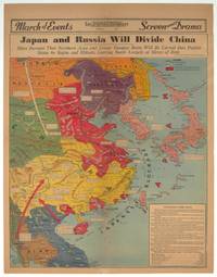
1940209821Los Angeles.: Los Angeles Examiner. 1940. Printed colour pictorial map on a single newspaper leaf 42.3 x 39.9 cms; 54.3 x 42.5 cms sheet archivally laid down on linen slight discoloration to lower centrefold and sheet slightly age-toned but in very good condition. A striking geopolitical map by Los Angeles Examiner artist Howard Burke covering China Japan Southern Russia and the northern part of French Indochina and Siam showing how the "Aggressors Divide China." Areas under Japanese occupation are shown in red and their naval blockade shown by an arc of naval vessels with vivid arrows indicating lines of supply. Text labels including sources of agricultural and raw materials provide a dynamic overview of the geopolitical situation and show the influence of American scientific illustrator and cartographer Richard Edes Harrison who argued for examining geographic issues from multiple perspectives and Los Angeles Times artist Charles Owens. . Los Angeles Examiner. unknown
1806009589London: Printed for Richard Phillips Sold By Souter No. 1 Pater-noster-row. 1806. Book. Very Good. Hardcover. First Edition. Large 4to. A very good "large paper" copy with uncut edges leaf size approximately 285mm x 225mm with a few additional items bound in. Pp. xiv 2 530 ii ii. 16 hand-tinted aquatints of which several folding map plus an additional contemporary hand-coloured map of Ireland as frontispiece. Contents: frontispiece quarto format map - engraved for the Poem of Erin. The folding plate of Dublin shown as the frontispiece in the "Directions for Placing the Plates" has been bound in opposite the first page of text title page dedication prefacecontents errata directions for placing the engravings main body of the text additional page on St. Patrick from "Guide to Knowledge" bound in at rear before the Publisher's adverts cutting from the Times 1842 entitled "Robert Emmet and the Gaoler of Kilmainham" pasted to rear paste-down. Original paper-covered boards with recent pebbled cloth spine to match original with the original paper title-label applied to the spine binding in very good condition. Contents very good the uncut edges are a little worn in places and a couple of a small near-contemporary oval stamps of the "Baptist College Bristol" to the front end paper no other marks. Paper in very good condition without any obvious staining minimal foxing almost completly confined to the tissue guards maps and plates all very good clean and crisp short repaired tear to the edge of page 318 not nearly affecting the text. A very good to fine copy. Printed for Richard Phillips, Sold By Souter, No. 1, Pater-noster-row. Hardcover
186763963New York NY: Taintor Brothers Merrill & Co. 758 Broadway c. 1867 ca. 1870. One large folio colour lithograph map sized 19.5 x 25 in. expertly mounted on linen decorative border neatline very faint dustsoiling marks from when originally folded very slight age toning at the former creases still a VG bright copy. Early printing of this splendid map depicting the five boroughs before their consolidation 30 years later in 1898 and offering a superb snapshot of the streets ferry lines waterways and Harbor. New York rapidly changed during the end of the 19th Century with tremendous influx of immigrants into the City and this map captures a pivotal time. Joseph Taintor 1835-1881 established this mapmaking firm with his brother Charles Taintor in 1866 and after 1868 when they changed the name of the firm they added their Uncle and entered the field of school book pubishing including the Analytical Readers series. See: David Rumsey Historical Map Collection City of New York No. 0973.003. Taintor Brothers, Merrill & Co., 758 Broadway, unknown
1943144341943. Archive of nine large original World War II maps used by a United States Army soldier in the European Theater of Operations during the Allied liberation of Western Europe. Lithographed military maps variously issued by U.S. Army and War Office agencies 1943-1944. Large formats ranging from approximately 19" x 24" to 42" x 34". These maps document the cartographic infrastructure of Allied ground and air operations in the climactic campaigns of 1944-1945. The German sheets-many designated for "Army/Air" or restricted War and Navy Department use-reflect the intensive aerial reconnaissance bombing coordination and mechanized advance into the industrial and administrative heartland of the Third Reich. Cities such as Berlin Magdeburg Kassel and Düsseldorf were central to armaments production rail networks and military command making accurate and rapidly updated mapping indispensable. The Paris map corresponds to the Allied advance culminating in the Liberation of Paris in August 1944 marking the symbolic reclamation of a major European capital from Nazi control. Several sheets note reliance on prewar German cartography 1938 editions supplemented by wartime intelligence underscoring how Allied forces repurposed and revised enemy geographic data for invasion and occupation planning.<br /> <br /> Crucially these maps also capture a political geography that was almost immediately transformed by postwar settlement and Soviet expansion into Central and Eastern Europe. Within two years of their issue Germany was divided into occupation zones and by 1949 into separate states aligned with Western and Soviet blocs. Cities such as Berlin Halle Saale Magdeburg and Wernigerode fell within the Soviet zone and subsequently the German Democratic Republic fundamentally altering administrative boundaries transportation networks and the ideological framing of space. Cartographic production in these regions shifted accordingly with new editions reflecting socialist state structures and restricted internal mapping policies characteristic of the emerging Eastern Bloc. Thus these 1943-1944 sheets preserve a transitional moment: Nazi Germany still territorially intact on paper yet already subjected to Allied military penetration and poised on the brink of partition. As artifacts carried by an American soldier they embody both the tactical prosecution of total war and the immediate redrawing of Europe into Cold War spheres of influence. The archive includes operational maps of Magdeburg Sheet M.53 1:250000 "First Edition" 1943 with manuscript annotation Kassel Sheet L52 "Emergency Road Map" First Edition color based on 1938 mapping with wartime intelligence updates Düsseldorf Sheet K52 similar issue with fading highlighting and manuscript marks Hanover Sheet L53 1943 Berlin Sheet N53 "Army/Air" 1943 Halle Saale Sheet M52 marked "War and Navy Department Agencies only. Not for sale or distribution" 1943 Wernigerode Sheet 4130 First Edition War Office 1944 Jülich G.S.G.S. No. 4507 War Office 1944 35" x 30" and a large U.S.-issued map of Paris 42" x 34" 1944. All were retained by the soldier following his service.<br /> <br /> Very good overall with expected wartime folds and handling; several sheets with manuscript annotations highlighting fading or moderate water exposure notably Wernigerode stiffened from dampness; no major losses observed. A substantial and research-rich archive of original Allied operational maps materially linking frontline navigation aerial bombardment liberation campaigns and the swift geopolitical reconfiguration of Germany and Europe under the expanding Soviet Eastern Bloc. unknown
19351395167New York: Harcourt Brace and Company 1935. First Edition Fourth Printing. Hardcover. Octavo 255 pages. In Very Good minus condition and lacking issued dust jacket. Bound in dark blue cloth with silver gilt lettering on spine. First edition fourth printing as stated on copyright page. Foxing to boards with light fraying to cloth along edges. Top edge of textblock dyed dark blue though faded. Toning to interior pages and tanning to pastedowns. Inscribed by Anne Morrrow Lindbergh on second endpaper in Spanish. Shelved in Case 9. 1395167. Shelved Dupont Bookstore. Harcourt, Brace and Company hardcover
1944144301944. Collection of German produced maps created during World War II documenting military geography industrial targets and occupied territories across Europe. Printed between approximately 1939 and 1945 the maps reflect the cartographic infrastructure used by the German military and administrative authorities during the conflict. They include operational target mapping of industrial facilities in Britain as well as broader geographic maps of Central and Western Europe produced during the period of German expansion and occupation. The materials illustrate the strategic importance of cartography in wartime planning intelligence gathering and territorial administration.<br /> <br /> Archive of ten German language maps printed circa 1939-1945. The group includes a German aerial bombing target map of the Chesterfield Tube Works in Great Britain dated December 1942 showing an aerial photographic image of the factory area overlaid with roads bridges and designated target points. The document bears the warning "Nur für den Dienstgebrauch" translated as "For Internal Use Only." The Chesterfield Tube Works produced industrial cylinders and compressors important to the Allied war effort and German bombing raids targeted the factory and nearby rail lines; one recorded bombing attempt reportedly missed the intended target and struck a golf course several miles away. The archive also includes a map titled Karte der ehemaligen Tschechoslowakei "Map of the Former Czechoslovakia" printed with red elevation markings and bearing the headline "Sonderausgabe!" "Special Edition!" produced during the period of German occupation following the annexation of the Sudetenland in 1938 and the subsequent occupation of the remainder of Czechoslovakia in 1939. Additional maps depict the city of Plzeň located at the edge of the Sudetenland and occupied by German forces during the war along with maps of Köln Cologne Umgebung von Wien surroundings of Vienna and broader geographic overview maps labeled Deutsches Reich Frankreich and Italien. One large overview sheet titled Blatt Südost includes a color printed regional map with scale 1:1000000.<br /> <br /> During World War II the production of detailed maps formed a central component of military planning aerial reconnaissance and territorial administration across Europe. German cartographic units compiled aerial imagery industrial intelligence and geographic data to support bombing operations and to administer occupied territories. Maps such as the Chesterfield industrial target sheet demonstrate how aerial photography and cartographic overlays were combined to identify transportation networks and industrial infrastructure vulnerable to bombing campaigns. Other maps in the archive reflect the shifting political geography of Europe under Nazi occupation including representations of territories incorporated into or controlled by the German Reich. The group contains ten maps of varying sizes including large wall maps exceeding 50 inches in width. Several maps show signs of use including wear and annotations; the Plzeň map lacks the original key section. Overall condition ranges from good to very good with occasional handling wear consistent with wartime cartographic materials. A substantial group of World War II German maps documenting both strategic planning and the geography of occupied Europe. unknown
GOR003375157Paperback. Acceptable. paperback