12 878 résultats
115638aafLeipzig, T.O. Weigel, 2000, imp.-Fol. (55 x 39 cm) und in-4to, 2 Bl. (Titelblatt - Verzeichnis der Tafeln und Karten) + 22 meist farbige lithograph. Tafeln davon 3 doppelblattgr. + 8 Umrisstafeln (zu Tafel 7-9, 11-14, und 20), dem Original im Zentral-Bibliothek entsprechend mit wenigen Feuchtflecken, Halbleinenmappe mit Ecken.
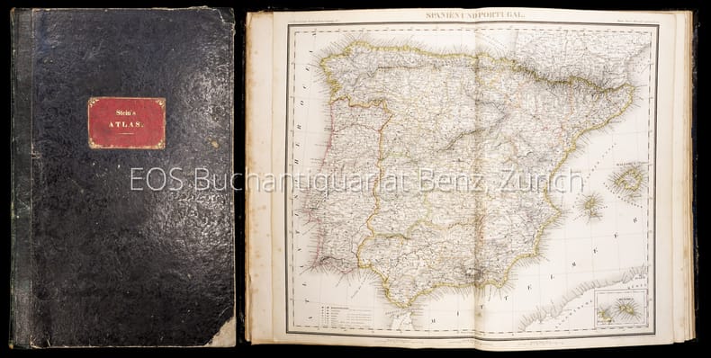
18524004DBSechsundzwanzigste Auflage. Leipzig, Verlagseigenthum der J.C. Hinrichs'schen Buch- und Landkartenhandlung, 1852. Folio. (11) Bl. (dv. 9 gef.). Mit 26 doppelblattgrossen kolorierten Stahlstichkarten. Halblederband der Zeit.
92486aafAu frais de Mr. J.R. Meyer à Aarau, 1796, imperial in-folio, Levée et dessinée par J. H. Weiss et gravée par MG. Eichler, feuille enroulé, quelques petites déchirures sur le bord (ne touchent pas la carte), bon état.
1808163151808 br. papier bleu moucheté, dos demi-toile, usagé (Empoussiéré, pl. détachées, mq. coin inf. droit du titre sans manque de texte). in-8, 6pp., 29 planches montées sur onglets, P. 1808
183659541Darmstadt, Litho. Anst. Fromann, 1836-38 (40). Folio-oblong. (39,5 x 51 cm.). Contemp. hcalf. Spine worn. Corners weared down. With 37 outlinecoloured lithographed maps. Numbered II-XXXVI (Titlepage numb. I lacks, and 2 extra maps numbered XXVIII b and XXXI b present (XXXI b, dated 1840), most of the other maps dated 1836, 1837 a. 1840). The maps having, sometimes rather heavely, dampstaining throughout. 2 maps with closed tears. A map added, not belonging to the atlas ""Charte und Meilenzeiger Daenemark mit Schleswig. Holstein. Lauenburg. Entworfen von Euard v. Grubl. Flensburg 1837"". Some brownspots and a bit of lower right corner gone.
182525408Weimar, in Verlage des Geographischen Instituts, 1825-28. Folio. Each 49x60 cm. 5 steel-engraved maps depicting the 5 parts of Prussia. All Handcoloured in outline. Cont. blank wrappers, wrappers partly lost. All maps with broad margins with use and tears, one tear reaching engraved surface. Some soiling. The last 2 maps dampstained in right corners.
183659541Darmstadt Litho. Anst. Fromann 1836-38 40. Folio-oblong. 395 x 51 cm. Contemp. hcalf. Spine worn. Corners weared down. With 37 outlinecoloured lithographed maps. Numbered II-XXXVI Titlepage numb. I lacks and 2 extra maps numbered XXVIII b and XXXI b present XXXI b dated 1840 most of the other maps dated 1836 1837 a. 1840. The maps having sometimes rather heavely dampstaining throughout. 2 maps with closed tears. A map added not belonging to the atlas "Charte und Meilenzeiger Daenemark mit Schleswig. Holstein. Lauenburg. Entworfen von Euard v. Grubl. Flensburg 1837". Some brownspots and a bit of lower right corner gone. <br/><br/><em>First edition of Glaser's world-atlas where the lacking title-page should be dated 1839. "The map sheets were to a large extent modeled on Stieler's handatlas. The maps were not simple copies however. They were newly drawn as can be seen for example in fact that some sheets were rotated 90 degrees. Glaser also chose to use a map sheet measuring 406 x 495 cm. a larger format than that of the Stieler whose sheets at that time were 363 x 442 cm. This enabled him to use a somewhat larger scale than that found in the STIELER."Jürgen Espenhorst Petermann's Planet p. 1013. </em> unknown
182525408Weimar in Verlage des Geographischen Instituts 1825-28. Folio. Each 49x60 cm. 5 steel-engraved maps depicting the 5 parts of Prussia. All Handcoloured in outline. Cont. blank wrappers wrappers partly lost. All maps with broad margins with use and tears one tear reaching engraved surface. Some soiling. The last 2 maps dampstained in right corners. <br/><br/><em>Contents. 1. Charte v. d. Königl. Preuss. Provinz Schlesien. - 2.Pommern. 3.Brandenburg. - 4.Sachsen. - 5. Westphalen und die Rhein-provinz. </em> unknown
187642075Gotha Justus Perthes Maps dated 1876. Folio. Orig. full cloth blindstamped and gilt frontboard. Corners bumped edges worn covers with scratches. 2 pp. and 31 steel-engraved double-page coloured maps. Light browning to lower margins of some maps otherwise clean. <br/><br/><em>With maps of all the Continents Europe The Hemispheres etc. </em> hardcover
187743308Gotha Justus Perthes n.d. 1877-78 Folio. Orig. full blindstamped cloth. Frontcover with gilt title. Lower part of spine ca. 8 cm. lacks and top of spine with some wear otherwise fine. With 31 double-page 37x435 steel-engraved maps with outline colouring. All maps clean and fine. Maps dated 1877 a. the last 1878. hardcover
187642075Gotha, Justus Perthes, (Maps dated 1876). Folio.. Orig. full cloth, blindstamped and gilt frontboard. Corners bumped, edges worn, covers with scratches. (2) pp. and 31 steel-engraved double-page coloured maps. Light browning to lower margins of some maps, otherwise clean.
187743308Gotha, Justus Perthes, n.d. (1877-78) Folio. Orig. full blindstamped cloth. Frontcover with gilt title. Lower part of spine (ca. 8 cm.) lacks, and top of spine with some wear, otherwise fine. With 31 double-page (37x43,5) steel-engraved maps with outline colouring. All maps clean and fine. Maps dated 1877 a. the last 1878.
BN66307Atlas and Synopsis Der Klinischen Dermatologie : German Version of Colour Atlas and Synopsis of Clinical Dermatology: Pleas Fitzpatrick <br/><br/> unknown
BN66280Lehrbuch und Atlas der Bronchoskopie: Geschichte Techniken Krankheitsbilder Dobbertin Ingrid and Dierkesmann Rainer <br/><br/> unknown
188162541Neillsville & Wasau WI: Bussell & Holway Civil Engineers 1881. 8vo. 180 pp unpaginated. with double-page engraved title plat maps throughout primarily on facing recto & verso of leaves while some are overlapping and on next blank continuing w/ laid-in Township Range Plat Map MS on form 4-590 demarcating Government Land and dated March 6 1895 inserted into rear pocket annotations demarcating plat changes red ink markings of “Government Land†w/ V’s and other annotations on several of the maps in Marathon County by former real estate land surveyor. Contemporary black calf rebacked hinges restored w/ thumbing some edgewear still a VG- copy. First edition of this detailed and compact pocket plat map atlas issued by Bussell b. 1854 was a surveyor/civil engineer based out of nearby Neillsville Clark WI and his partner Holway for lands platted through Marathon County Wisconsin in the 19th-Century as the centrally located County opened for logging and settlement on lands driven by the Wisconsin Central Railroad and the Wisconsin Valley Railroad later the Wisconsin Valley Land Company. This exceptional reference provides names of all the original homesteaders and plat-holders as of the time of publication as well as demarcating houses churches schools mills U.S. Government lands state lands as well as the lines for the Lake Shore Traffic Co. Dundee Land Co. and development lands of the C.P. Haseltine Co. Worldcat locates only 1 physical copy at Library of Congress Wisconsin Historical Society does have a scanned searchable copy available online; See: Louise Marchetti History of Marathon County Wisconsin and Representative Citizens 1913. Bussell & Holway, Civil Engineers, unknown
Very Good Turkish, Ottoman (1500-1928) Original pictorial wrappers. Chromo-lithographed photo-montage collage cover with seven b/w photos of African buildings and natives, and a red map of Africa. Complete in wrappers and folded huge Africa map (size: 57 x 82 cm). Cover size: 28.5 x 20.5 cm. In Turkish. Scale: 1/20,000,000. A very rare chromo-lithographed Africa map, prepared for the geography lessons about foreign countries in Turkey in 1930. The map shows the territories of the African continent, which was still politically under European colonialism as of the 1930s. It includes Rio de Oro (Spanish territory), Fas [i.e. Morocco], Algeria, Sahara, Cameroon (French territories), Trabulus [i.e. Libya] as Italian territory; and Liberia, Egypt, East Sudan, Eritre [i.e. Eritrea], Habesistan [i.e. Ethiopia], Somali, Kenya, Belgian Kongo, Angola, Mozambique and South African land including Rhodesia (equivalent in the territory to modern Zimbabwe), Transvaal, The Orange Free State [Oranje-Vrystaat], Natal and Kap [Cape] with Madagascar. An extra panel for the same scale map showing the Suez Canal, Nile Delta, and North Egypt in the lower-left corner. Duran studied in Istanbul and Paris. He worked as a geography teacher in various high schools and afterward he undertook the positions of lecturer and administrator in Ankara Gazi Education Institute for a time. He was known for his writings on various topics and particularly for his works on geography. Born in the imperial period, Duran conducted the first cartographic studies of the Republic of Turkey after the transition to the Republican administration. Sealed. Slight foxing. Otherwise a fine copy. Not in OCLC.
Very Good French Original decorated map. Hand-coloured. Oblong elephant folio. (54 x 76 cm). In French. Shows Greece, Archipelago, Isle de Candie, Asia Minor (Western side), and East Mediterranean. Delisle od de l'Isle was a French cartographer known for his popular and accurate maps of Europe and the newly explored Americas. At 27, Delisle was admitted into the French Académie Royale des Sciences, an institution financed by the French state. After that date, he signed his maps with the title of "Géographe de l'Académie". Five years later, he moved to the Quai de l'Horloge in Paris, a true publishing hub where his business prospered. Delisle's progress culminated in 1718 when he received the title of Premier Géographe du Roi. He was appointed to teach geography to the Dauphin, King Louis XIV's son, a task for which he received a salary. Again, his father's reputation as a man of science probably helped the younger Delisle. Historian Mary Sponberg Pedley says, 'once authority was established, a geographer's name might retain enough value to support two or three generations of mapmakers'. Delisle's case, it could be said that his accomplishments surpassed his father's. Up to that point, he had drawn maps not only of European countries, such as Italy, Spain, Germany, Great Britain, Poland, and regions such as the Duchy of Burgundy, but he had also contributed to the empire's claims to recently explored continents of Africa and the Americas. Like many cartographers of his day, Delisle did not travel with the explorers. He drew maps mostly in his office, relying on a variety of data. The quality of his maps depended on a solid network to provide him first-hand information. Given his family's and his own reputation, Delisle had access to fairly recent accounts of travellers who were returning from the New World, which gave him an advantage over his competitors. Being a member of the Académie, he also kept current with recent discoveries, especially in astronomy and measurement. When he could not confirm the accuracy of a source, he would indicate it clearly on his maps. For instance, his Carte de la Louisiane shows a river that the baron of Lahontan claimed he discovered. As no one else could validate it, Delisle noted a warning to the viewer that it might not exist. (Source: Wikipedia). Tooley, p.43.
Very Good Turkish, Ottoman (1500-1928) Original color map on cloth. A little foxing on cloth. Very good. Folded. Oblong atlas folio. (66 x 72 cm). In Ottoman script. Scale: 1/210.000. Ottoman sanjaks in Albania and Greece. A rare Ottoman map of Balkans with Turkish place names for the period of pre-Balkan Wars, (1912-1913). Very important for onomastics and historical geography. Written 'Paris -French meridian- was accepted as the 0 meridian'. The Paris meridian is a meridian line running through the Paris Observatory in Paris, France-now longitude 2°20'14.03" east. It was a long-standing rival to the Greenwich meridian as the prime meridian of the world. Personal stamp of Muhiddin Pasha on cloth, under the printed descriptive texts. It's from the collection of him. Hasan Muhiddin Pasha [Çanga], (1866-1944), who was a lieutenant in Hedjaz Army of the Ottoman Empire in 1887. After he suppressed the rebellion in Yemen, 1891, his rank was promoted to the 'major'. After the Imam Yahya rebellion in Yemen, 1904, he prepared a report for the Ottoman government. He also took part in Ethiopia, Sudan, Yemen, Arabian Peninsula for various military duties. After promotion to division command, he was provincial president of CHP (Republican People's Party). He was a very important politic and diplomatic figure for the last period of Ottoman and early Republican Turkey. Not in Tooley. Extremely rare.
Very Good Turkish, Ottoman (1500-1928) Original color map on cloth. A little foxing on cloth. Very good. Folded. Oblong atlas folio. (66 x 72 cm). In Ottoman script. Scale: 1/210.000. Ottoman cities in Bulgaria. A rare Ottoman map of Balkans with Turkish place names for the period of pre-Balkan Wars, (1912-1913). Very important for onomastics and historical geography. Written 'Paris -French meridian- was accepted as the 0 meridian'. The Paris meridian is a meridian line running through the Paris Observatory in Paris, France-now longitude 2°20'14.03" east. It was a long-standing rival to the Greenwich meridian as the prime meridian of the world. Personal stamp of Muhiddin Pasha on cloth, under the printed descriptive texts. It's from the collection of him. Hasan Muhiddin Pasha [Çanga], (1866-1944), who was a lieutenant in Hedjaz Army of the Ottoman Empire in 1887. After he suppressed the rebellion in Yemen, 1891, his rank was promoted to the 'major'. After the Imam Yahya rebellion in Yemen, 1904, he prepared a report for the Ottoman government. He also took part in Ethiopia, Sudan, Yemen, Arabian Peninsula for various military duties. After promotion to division command, he was provincial president of CHP (Republican People's Party). He was a very important politic and diplomatic figure for the last period of Ottoman and early Republican Turkey. Not in Tooley. Extremely rare.
Very Good Turkish, Ottoman (1500-1928) Original color map on cloth. A little foxing on cloth. Very good. Folded. Oblong atlas folio. (66 x 72 cm). In Ottoman script. Scale: 1/210.000. Ottoman sanjaks in Greece, mostly in Greek Macedonia. A rare Ottoman map of Balkans with Turkish place names for the period of pre-Balkan Wars, (1912-1913). Very important for onomastics and historical geography. Written 'Paris -French meridian- was accepted as the 0 meridian'. The Paris meridian is a meridian line running through the Paris Observatory in Paris, France-now longitude 2°20'14.03" east. It was a long-standing rival to the Greenwich meridian as the prime meridian of the world. Personal stamp of Muhiddin Pasha on cloth, under the printed descriptive texts. It's from the collection of him. Hasan Muhiddin Pasha [Çanga], (1866-1944), who was a lieutenant in Hedjaz Army of the Ottoman Empire in 1887. After he suppressed the rebellion in Yemen, 1891, his rank was promoted to the 'major'. After the Imam Yahya rebellion in Yemen, 1904, he prepared a report for the Ottoman government. He also took part in Ethiopia, Sudan, Yemen, Arabian Peninsula for various military duties. After promotion to division command, he was provincial president of CHP (Republican People's Party). He was a very important politic and diplomatic figure for the last period of Ottoman and early Republican Turkey. Not in Tooley. Extremely rare.
Very Good Turkish, Ottoman (1500-1928) Original color map on cloth. A little foxing on cloth. Very good. Folded. Oblong atlas folio. (66 x 72 cm). In Ottoman script. Scale: 1/210.000. Ottoman sanjaks in Greece, mostly in Thessaly. A rare Ottoman map of Balkans with Turkish place names for the period of pre-Balkan Wars, (1912-1913). Very important for onomastics and historical geography. Written 'Paris -French meridian- was accepted as the 0 meridian'. The Paris meridian is a meridian line running through the Paris Observatory in Paris, France-now longitude 2°20'14.03" east. It was a long-standing rival to the Greenwich meridian as the prime meridian of the world. Personal stamp of Muhiddin Pasha on cloth, under the printed descriptive texts. It's from the collection of him. Hasan Muhiddin Pasha [Çanga], (1866-1944), who was a lieutenant in Hedjaz Army of the Ottoman Empire in 1887. After he suppressed the rebellion in Yemen, 1891, his rank was promoted to the 'major'. After the Imam Yahya rebellion in Yemen, 1904, he prepared a report for the Ottoman government. He also took part in Ethiopia, Sudan, Yemen, Arabian Peninsula for various military duties. After promotion to division command, he was provincial president of CHP (Republican People's Party). He was a very important politic and diplomatic figure for the last period of Ottoman and early Republican Turkey. Not in Tooley. Extremely rare.
Very Good Turkish, Ottoman (1500-1928) Original color map on cloth. A little foxing on cloth. Very good. Folded. Oblong atlas folio. (66 x 72 cm). In Ottoman script. Scale: 1/210.000. Ottoman sanjaks in Greece. A rare Ottoman map of Balkans with Turkish place names for the period of pre-Balkan Wars, (1912-1913). Very important for onomastics and historical geography. Written 'Paris -French meridian- was accepted as the 0 meridian'. The Paris meridian is a meridian line running through the Paris Observatory in Paris, France-now longitude 2°20'14.03" east. It was a long-standing rival to the Greenwich meridian as the prime meridian of the world. Personal stamp of Muhiddin Pasha on cloth, under the printed descriptive texts. It's from the collection of him. Hasan Muhiddin Pasha [Çanga], (1866-1944), who was a lieutenant in Hedjaz Army of the Ottoman Empire in 1887. After he suppressed the rebellion in Yemen, 1891, his rank was promoted to the 'major'. After the Imam Yahya rebellion in Yemen, 1904, he prepared a report for the Ottoman government. He also took part in Ethiopia, Sudan, Yemen, Arabian Peninsula for various military duties. After promotion to division command, he was provincial president of CHP (Republican People's Party). He was a very important politic and diplomatic figure for the last period of Ottoman and early Republican Turkey. Not in Tooley. Extremely rare.