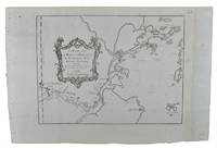
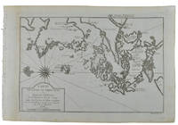
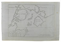
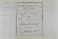
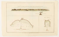
55 résultats
174019595(Augsburg), Matthäus Seutter, um 1740. Ca. 50 cm x 58 cm (Platte).
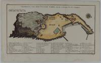
1748175859Leipzig.: Schwabe Johann Joachim. 1748. Engraved map on laid paper 20.5 x 36 cm plate -mark inc. captions 24 x 39 cm sheet size original fold later hand-colouring slight marginal spotting but in very good condition. Fine 18th century ground plan of Gorée Island off the coast of Senegal infamous for its association with slavery. The map shows encampments and forts with a detailed key. Originally published in Abbe Prevost's "Histoire générale des voyages." 1746 -1789 with maps and plans by the great cartographer Jacques-Nicolas Bellin this was prepared for volume two of the the German edition "Allgemeine Historie der Reisen." published in 1748. . (Schwabe, Johann Joachim) unknown
1749136827Paris. Circa1749. Engraved map on watermarked laid paper 20 x 27.3 cm of Fuzhou and coastline of Fujian Province original folds designed by the great French cartographer Jacques-Nicolas Bellin. This map is from the impressive 15-volume "Histoire Génèrale des Voyages" compiled by Antoine François Prévost map no. 2 Vol. 6. This map shows the estuary of Yangtze River Rivière de Chang. Very light browning on sheet edges but in very good condition. . unknown
1749136826Paris. circa1749. Black and white engraved map on watermarked laid paper 20.9 x 32.7cm showing coastal area of Zhejiang Province Province de Che-kiang including Zhoushan Archipelago Isle de Chusan Zhoushan Bay Bay de Chusan and Xiangshan County Siang-chan-luen a walled city outside of upper border Ningbo Ning-po prefecture under Qing administration title cartouche lower left original folds. This map is No. 3 Vol. 6 from the impressive 15-volume "Histoire Generale des Voyages" compiled by Antoine François Prévost. Even browning mainly to the sheet edges in very good condition. . unknown
1749136795Paris. circa1749. Black and white engraved map of Quanzhou and Zhangzhou 21.1 x 30 cm here spelled Chin-chew and Chang-chew and both final words with added superscript "ou" on watermarked laid paper 25.6 x 38 cm original folds a few marginal spots simplified compass rose and a decorative fleur de lis bottom right in very good condition. Attractive map including the estuary of Quanzhou River Xiamen Emowi and Kinmen or Quemoy Quemowi island. The map was designed by the eminent French cartographer Jacques-Nicolas Bellin and here published as plate No. 22 in the impressive 15 volume compilation of voyages "Histoire Generale des Voyages" by Antoine François Prévost. . unknown
1749136781Paris. circa1749. Black and white engraved map on laid paper showing entrance to Pearl/Canton river Macao and the area which would become Hong Kong Sinn-gan-hien folded designed by the prominent French cartographer Jacques-Nicolas Bellin. This map is No. 16 Vol. 5 from the impressive 15-volume "Histoire Generale des Voyages" compiled by French novelist Antoine François Prévost. The walled city of Canton upper section is divided into areas of Tartar and Chinese. <br> <br>Some light even browning on paper added at margins good copy. Map measures 25.7 x 20.5. . unknown
1749136794Paris. circa1749. Black and white engraved plan map of Peking on laid paper folded designed by the prominent French cartographer Jacques-Nicolas Bellin. This map is No. 18 Vol. 5 from the impressive 15-volume "Histoire Generale des Voyages" compiled by French novelist Antoine François Prévost. This city map shows two areas of walled cities: Ville Tartare Imperial city and the Forbidden City and Ville Chinoise ethnic Han residential area. <br> <br>Notes A and B represents buildings within the Forbidden City. A: Lieu de Plaisance ou l'on voit une Montagne faite a la main B: Grandes Cours du Palais de l'Empereur. Two missionary buildings French and Portuguese as well as the Tower of Mathematics illustrated within Ville Tartare. Two temples illustrated side by side near the south gate of the Ville Chinoise. <br> <br>Overall in good condition very light browning on edges and darker toning along the borders of the map. Text in French. Map measures 21 x 16.4cm. . unknown
179521088Brest 1795 1 feuillet avec en-tête préimprimé : Liberté Egalité AU NOM DE LA REPUBLIQUE FRANCAISE et orné d'une vignette en noir (avec symboles révolutionnaires : faisceaux d'Armes et bonnet Phrygien), manuscrit à l'encre brune sur papier vergé ligné filigrané, format 19,4 centimètres de large par 30,5 centimètres de haut, Lettre écrite à BREST, le 23 Germinal 3ème année républiquaine, signature manuscrite de THIRAT,
172354819Rainer Ottens. 1723. A most attractive map with early outline hand colour vertical fold barely visible diagonal crease upper half of map few very pale small brown spots otherwise a clean and bright image. Numbering in red pencil few annotations in pencil and light number stamp on reverse however not at all visible from front of map or affecting image. Sheet measures 46.6 x 60.2cm. . Rainer Ottens. unknown
1796209283London.: George Nicol. 1796. Engraved copperplate map on Whatman paper 43.8 x 33.6 cm; 57 x 42 cm sheet including plate markscale in nautical and English miles; light undulation to sheet marginal toning and edgewear but in very good condition. Finely engraved and detailed map of two routes to Pekin Beijing along the White River Baihe from the Gulf of Petcheli and along the Imperial Highway from Jehol and includes commentary locating palaces and gardens type of cultivation "many barges" and "the road shaded by willow trees". The map elegantly drawn by Henry William Parish was published in George Staunton's account of Earl Macartney's embassy to China 1792-1794. . George Nicol. unknown
1703176390Amsterdam. circa1703. Engraved map on watermarked laid paper 16.5 x 26.5 cm plate-mark 26 x 42 cm sheet key in German inset detail of grave sites on the island of "Rhenee" Rineia and Apollonian relics lower corner creased and with a sealed tear to the verso no loss in very good condition. Fine engraving with large margins of the Greek island of Delos of great significance to classical antiquity and the mythological birthplace of the Greek deities Artemis and Apollo. . unknown
1795210851795 1 feuillet avec en-tête préimprimé : MARINE LIBERTE, EGALITE, FRATERNITE et orné d'une vignette en noir, manuscrit à l'encre brune sur papier vergé ligné filigrané, format 20 centimètres de large par 30,8 centimètres de haut, Lettre écrite à bord de la Frégate "LA NEREÏDE", le 13 Floréal An 3, signature manuscrite de Jean-Pierre PILLET
1750177186circa1750. Hand-coloured engraving 19.5 x 35.6 cm 25.5 x 41.6 cm sheet original folds two old paper repairs not affecting the image a trifle toned but in very good condition Attractive bird's-eye view town plan of Makassar in Sulawesi prepared for Abbé Prevost's monumental 'Histoire Générale des Voyages.' . unknown
179521641Lorient 1795 1 feuillet avec en-tête préimprimé en noir : Liberté Egalité Fraternité et orné d'une vignette en noir (avec symboles révolutionnaires : faisceaux d'Armes et bonnet Phrygien ), manuscrit à l'encre brune sur papier vergé bleuté ligné filigrané, format 17,7 centimètres de large par 23,5 centimètres de haut, Lettre écrite à LORIENT, le 15 Messidor An 3 (3 juillet 1795) de la République Française, signature manuscrite de DAVID, Chef des Bureaux civils de la Marine, chargé des Armemens et des Classes, au port de LORIENT,
179621090Brest 1796 1 feuillet avec en-tête préimprimé en noir : Liberté Egalité Fraternité et orné d'une vignette en noir (avec symboles révolutionnaires : faisceaux d'Armes et bonnet Phrygien et marianne avec imprimé en bas "république Française"), manuscrit à l'encre brune sur papier vergé ligné filigrané, format 22,6 centimètres de large par 33,8 centimètres de haut, Lettre écrite à LORIENT, le 1er Messidor, An 4 (1796), de la République Française, une et indivisible, signature manuscrite de l'Adjudant Général MOLINI et de Mr BIVAUX secrétaire du Bureau de l'Etat Major Général de la Marine de Lorient,
179521642Lorient 1795 1 feuillet avec en-tête préimprimé en noir : Liberté Egalité Fraternité et orné en tête d'une grande vignette en noir (avec symboles révolutionnaires : l'Oeil, la balance, les lauriers, les cornes d'abondances et le bonnet Phrygien avec imprimé en haut "département du Morbihan"), manuscrit à l'encre brune sur papier vergé bleuté ligné filigrané, format 20 centimètres de large par 31,5 centimètres de haut, Lettre écrite à LORIENT, e 17 nivose An 3 (6 janvier 1795) de la République Française, une et indivisible, signature manuscrite de PHILIPPE-ALEXIS-LAURENT HENRY, Chef de Division, Commandant des Armes au port de LORIENT,
179521640Lorient 1795 1 feuillet avec en-tête préimprimé en noir : Liberté Egalité Fraternité et orné d'une vignette en noir (avec symboles révolutionnaires : faisceaux d'Armes et bonnet Phrygien et marianne avec imprimé en bas "république Française"), manuscrit à l'encre brune sur papier vergé bleuté ligné filigrané, format 20 centimètres de large par 31 centimètres de haut, Lettre écrite à LORIENT, le 27 Messidor An 3 (15 juillet 1795) de la République Française, signature manuscrite de PHILIPPE-ALEXIS-LAURENT HENRY, Chef de Division, Commandant des Armes au port de LORIENT et de Mr BIVAUX secrétaire du Bureau de l'Etat Major Général de la Marine de Lorient
179621091Lorient 1796 1 feuillet avec en-tête préimprimé en noir : Liberté Egalité Fraternité et orné d'une vignette en noir (avec symboles révolutionnaires : faisceaux d'Armes et bonnet Phrygien et marianne avec imprimé en bas "république Française", manuscrit à l'encre brune sur papier vergé ligné filigrané, format 21,5 centimètres de large par 33,5 centimètres de haut, Lettre écrite à LORIENT, le 20 floreal, An 4 (1796), de la République Française, signature manuscrite de PHILIPPE-ALEXIS-LAURENT HENRY, Chef de Division, Commandant des Armes au port de LORIENT et de Mr BIVAUX secrétaire du Bureau de l'Etat Major Général de la Marine de Lorient,
1796176602circa1796. Engraved map 18.3 x 22 cm 21.7 x 27 cm sheet original folds age toning and some offsetting inner edge darkened and discoloured but the map in good condition. Finely engraved map showing Ireland divided into counties lower coast of Scotland and Wales and the Isles of Man and Anglesea; also noting Nymph Bank 'discovered in 1735 by Capt. Doyle.' . unknown
1718220781Japan.: 大海扇子商會. Taikai Sensu Shōkai. Meiji 17 1884. Black and white printed map with handcoloured pink highlights 23.5 x 39cm date stamped on reverse. A little minor wear at folds but overall very good. This fascinating fan was produced as a commemorative item marking a climb to the summit of Mount Fuji. A stamp on the reverse is dated 27 July Year 17 and appears to have been applied at the summit. This date likely refers to Meiji 17 or 1884. Commemorative fans of this type were popular at the time and the paper printing and general style appear consistent with that period. The red printed patterns and characters on the reverse also back up our belief that the fan was obtained at the summit. The pictorial map of the mountain shows four different routes to the summit marked in red with distance charts printed above. <br> <br>Mount Fuji is Japan’s highest peak. Long perceived as a sacred mountain it has a Shinto shrine at the summit and the climb has traditionally been regarded as a form of pilgrimage. . 大海扇子商會. [Taikai Sensu Shōkai]. unknown
179725649chambery 1797 1 document original sur papier velin crème ligné : FEUILLE DE ROUTE POUR JULIEN LAURENT [NATIF DE NANTES], BRIGADIER AU 7EME RÉGIMENT DE HUSSARDS COMPAGNIE N°7 PARTANT DE CHAMBÉRY POUR SE RENDRE A NANTES DÉLIVRÉE PAR CLAPIER : COMMISSAIRE DES GUERRES DE CHAMBERY DU 26 FRUCTIDOR AN V, format : 38,5 x 28 cm, préimprimé en noir et manuscrit à l'encre brune de deux pages, avec notés la liste des arrets dans les villes traversées avec signatures , cachet noir de la présidence de l'autorité municipale de Nantes gravé en noir, + 1 document original sur papier velin bleu ligné : CERTIFICAT DE VISITE ET CONGÉ ABSOLU POUR CAUSE DE BLESSURES [CERTIFICAT DE RÉFORME] DÉLIVRÉ PAR L'ARMÉE DES ALPES - HÔPITAL MILITAIRE D'AIX DU 17 FRUCTIDOR AN V (3 SEPTEMBRE 1797) SIGNÉ CLAPIER, format : 25 x 38 cm, certificat détaillé et signé côté Nantais par l'Autorité Municipale de Nantes (avec cachet illustré en noir et signature de CHEVY Ainé, Administrateur Municipal de la Commune de Nantes),
1784174895London.: Alexander Hogg at the King's Arms. circa1784. Engraved map on laid paper 21.4 x 33.7 cm inset of Gower's Simson's and Carteret's Island early outline hand colour trimmed to the plate mark at the top edge three small edge tears affecting the upper margin only slight paper toning but a most attractive map in very good condition. Fine impression of the Queen Charlotte's Islands Solomon Islands. It features the Swallow's track the ship's route taken by Captain Philip Carteret in 1767 the British naval officer and explorer who participated in two of the Royal Navy's circumnavigation expeditions in 1764–66 and 1766–69. . Alexander Hogg at the King's Arms. unknown
1784174896London.: Alexander Hogg at the King's Arms. circa1784. Engraved map in triptych on laid paper 20.1 x 32.7 cm three insets: cross section of the north side of Queen Charlotte's Islands Solomon Islands with detail of a volcano "6 leagues North"; Swallow's Bay Harbour; and Byron's Harbour early hand colour trimmed to the plate mark at the top edge neat sealed tear affecting the publisher's caption slight edge wear and paper toning but a most attractive map in very good condition. Attractive engraving of the Queen Charlotte's Islands Solomon Islands. The Islands were named for the consort of King George III by Philip Carteret the British naval officer and explorer who participated in two of the Royal Navy's circumnavigation expeditions in 1764–66 and 1766–69. His ship the Swallow gave her name to the Bay and Carteret's commanding officer on the first of his voyages John Byron to the Harbour depicted in this most attractive early chart. . Alexander Hogg at the King's Arms. unknown
179521089Brest 1795 1 feuillet avec en-tête préimprimé en noir : Liberté Egalité Fraternité et orné d'une vignette en noir (avec symboles révolutionnaires : faisceaux d'Armes et bonnet Phrygien et marianne), manuscrit à l'encre brune sur papier vergé bleuté ligné filigrané, format 19,8 centimètres de large par 31,5 centimètres de haut, Lettre écrite à ROCHEFORT, le 9 Prairial, An 3, de la République Française, une et indivisible, signature manuscrite de LELARGE,
179521092Brest 1795 1 feuillet avec en-tête préimprimé en noir : Liberté Egalité Fraternité et orné d'une vignette en noir (avec symboles révolutionnaires : faisceaux d'Armes et bonnet Phrygien et marianne), manuscrit à l'encre brune sur papier vergé crème ligné filigrané, format 18 centimètres de large par 24 centimètres de haut, Lettre écrite à ROCHEFORT, le 13 Germinal, An 3, de la République Française, une et indivisible, signature manuscrite de LELARGE,