[MAP] [CARY, JOHN, AFTER]Biblio.com
55 résultats
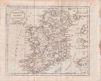
1796176602circa1796. Engraved map 18.3 x 22 cm 21.7 x 27 cm sheet original folds age toning and some offsetting inner edge darkened and discoloured but the map in good condition. Finely engraved map showing Ireland divided into counties lower coast of Scotland and Wales and the Isles of Man and Anglesea; also noting Nymph Bank 'discovered in 1735 by Capt. Doyle.' . unknown
1703176390Amsterdam. circa1703. Engraved map on watermarked laid paper 16.5 x 26.5 cm plate-mark 26 x 42 cm sheet key in German inset detail of grave sites on the island of "Rhenee" Rineia and Apollonian relics lower corner creased and with a sealed tear to the verso no loss in very good condition. Fine engraving with large margins of the Greek island of Delos of great significance to classical antiquity and the mythological birthplace of the Greek deities Artemis and Apollo. . unknown
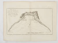
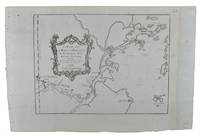
1774174260A Paris.: Chez Saillant et Nyon rue Saint-Jean-de-Beauvais Chez Panckoucke Hotel de Thou rue des Poitevins. 1774. Engraved map on laid paper 27.2 x 19.9cm 26.5 x 22.2cm sheet size edge fold slight marginal toning but in very good condition. Map of the treacherous coastal waters sandbars submerged rocks and reefs surrounding Mindanao and the Joseph Freewill Islands Mapia Atoll in the Philippines finely re-engraved for the French edition of Captain James Cook's First Voyage 1768-1771 "Relation des voyages.pour faire des decouvertes dans l'hemisphere meridional et successivement executes par le commodore Byron le capitaine Carteret le capitaine Wallis & le capitaine Cook.". . Chez Saillant et Nyon, rue Saint-Jean-de-Beauvais, [Chez] Panckoucke, Hotel de Thou, rue des Poitevins. unknown
1776GF308981776 Paris - Ribou - 1776 - 1 volume in8 broché d'origine de papier gris avec titre imprimé sur une étiquette blanche "Route de Rouen par St Germain - Numéro 2" - 46 pages - minimes accrocs à la couverture -
1776GF308991776 Paris - Ribou - 1776 - 1 volume in8 broché d'origine de papier gris avec titre imprimé sur une étiquette blanche "Route de Beauvais - Numéro 3" - 47 pages -
1776GF309001776 Paris - Ribou - 1776 - 1 volume in8 broché d'origine de papier gris avec titre imprimé sur une étiquette blanche "Route d'Amiens - Numéro 4" - 70 pages - petit accroc en queue -
1777GF309041777 Paris - Ribou - 1777 - 1 volume in8 broché d'origine de papier gris avec titre imprimé sur une étiquette blanche "Route de S. Omer par Amiens et Arras - Numéro 9" - IV - 48 pages - (couverture un peu tachée au dos) -
1777GF309061777 Paris - Ribou - 1777 - 1 volume in8 broché d'origine de papier gris avec titre imprimé sur une étiquette blanche "Route de Noyon et Saint Quentin - Numéro 12" - IV - 71 pages -
1777GF309071777 Paris - Ribou - 1777 - 1 volume in8 broché d'origine de papier gris avec titre imprimé sur une étiquette blanche "Route du Havre - Numéro 7" - 58 pages - (notes au crayon sur la couverture ) -
17865210Madrid: Don Antonio de Sancha 1786. Sm. 4to. 12400pp. Cont. limp vellum somewhat soiled hand lettered spine with a few small chips. Old faded water stains throughout & a blue oval library stamp on title page partially obscuring the text beneath it. Palau 41034. Don Antonio de Sancha hardcover books
1748175859Leipzig.: Schwabe Johann Joachim. 1748. Engraved map on laid paper 20.5 x 36 cm plate -mark inc. captions 24 x 39 cm sheet size original fold later hand-colouring slight marginal spotting but in very good condition. Fine 18th century ground plan of Gorée Island off the coast of Senegal infamous for its association with slavery. The map shows encampments and forts with a detailed key. Originally published in Abbe Prevost's "Histoire générale des voyages." 1746 -1789 with maps and plans by the great cartographer Jacques-Nicolas Bellin this was prepared for volume two of the the German edition "Allgemeine Historie der Reisen." published in 1748. . (Schwabe, Johann Joachim) unknown
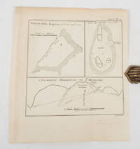
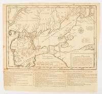
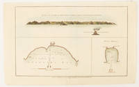
1774174257Paris.: Chez Saillant et Nyon rue Saint-Jean-de-Beauvais Chez Panckoucke Hotel de Thou rue des Poitevins. 1774. Engraved map on laid paper 18.5 x 31cm 25.6 x 34.4cm sheet size central fold slight marginal toning but a very good dark impression. Map of Bonthain Bay situated southeast of Macassar on the island of Celebes finely re-engraved for the French edition of Captain James Cook's First Voyage 1768-1771 "Relation des voyages.pour faire des decouvertes dans l'hemisphere meridional et successivement executes par le commodore Byron le capitaine Carteret le capitaine Wallis & le capitaine Cook.". . Chez Saillant et Nyon, rue Saint-Jean-de-Beauvais, [Chez] Panckoucke, Hotel de Thou, rue des Poitevins. unknown
179521088Brest 1795 1 feuillet avec en-tête préimprimé : Liberté Egalité AU NOM DE LA REPUBLIQUE FRANCAISE et orné d'une vignette en noir (avec symboles révolutionnaires : faisceaux d'Armes et bonnet Phrygien), manuscrit à l'encre brune sur papier vergé ligné filigrané, format 19,4 centimètres de large par 30,5 centimètres de haut, Lettre écrite à BREST, le 23 Germinal 3ème année républiquaine, signature manuscrite de THIRAT,
1749136795Paris. circa1749. Black and white engraved map of Quanzhou and Zhangzhou 21.1 x 30 cm here spelled Chin-chew and Chang-chew and both final words with added superscript "ou" on watermarked laid paper 25.6 x 38 cm original folds a few marginal spots simplified compass rose and a decorative fleur de lis bottom right in very good condition. Attractive map including the estuary of Quanzhou River Xiamen Emowi and Kinmen or Quemoy Quemowi island. The map was designed by the eminent French cartographer Jacques-Nicolas Bellin and here published as plate No. 22 in the impressive 15 volume compilation of voyages "Histoire Generale des Voyages" by Antoine François Prévost. . unknown
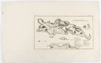
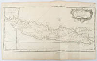
1750136782circa1750. Black and white copperplate engraving map of Java a little light even browning neat colour pencil highlighting of rivers and two settlements. Folded as issued. Good copy. 26 x 44cm. Issued in Prevost's Histoire Générale des Voyages ou nouvelle collection de toutes les relations de voyages par mer et par terre. . unknown
1739174921London.: The Gentleman's Magazine. circa1739. Engraved map 22.2 x 31.4 31.1 x 33 cm sheet size elaborate explanatory key in three columns at the foot original folds sealed 2 cm tear to the lower part of the inner margin one other small fold tear no loss inner margin of the key trimmed with some loss an original fault paper browned and spotted on the verso but an historic map in good condition. . [The Gentleman's Magazine]. unknown
1749136827Paris. Circa1749. Engraved map on watermarked laid paper 20 x 27.3 cm of Fuzhou and coastline of Fujian Province original folds designed by the great French cartographer Jacques-Nicolas Bellin. This map is from the impressive 15-volume "Histoire Génèrale des Voyages" compiled by Antoine François Prévost map no. 2 Vol. 6. This map shows the estuary of Yangtze River Rivière de Chang. Very light browning on sheet edges but in very good condition. . unknown
1749136826Paris. circa1749. Black and white engraved map on watermarked laid paper 20.9 x 32.7cm showing coastal area of Zhejiang Province Province de Che-kiang including Zhoushan Archipelago Isle de Chusan Zhoushan Bay Bay de Chusan and Xiangshan County Siang-chan-luen a walled city outside of upper border Ningbo Ning-po prefecture under Qing administration title cartouche lower left original folds. This map is No. 3 Vol. 6 from the impressive 15-volume "Histoire Generale des Voyages" compiled by Antoine François Prévost. Even browning mainly to the sheet edges in very good condition. . unknown
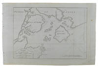
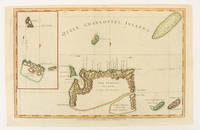
1784174896London.: Alexander Hogg at the King's Arms. circa1784. Engraved map in triptych on laid paper 20.1 x 32.7 cm three insets: cross section of the north side of Queen Charlotte's Islands Solomon Islands with detail of a volcano "6 leagues North"; Swallow's Bay Harbour; and Byron's Harbour early hand colour trimmed to the plate mark at the top edge neat sealed tear affecting the publisher's caption slight edge wear and paper toning but a most attractive map in very good condition. Attractive engraving of the Queen Charlotte's Islands Solomon Islands. The Islands were named for the consort of King George III by Philip Carteret the British naval officer and explorer who participated in two of the Royal Navy's circumnavigation expeditions in 1764–66 and 1766–69. His ship the Swallow gave her name to the Bay and Carteret's commanding officer on the first of his voyages John Byron to the Harbour depicted in this most attractive early chart. . Alexander Hogg at the King's Arms. unknown
1749136781Paris. circa1749. Black and white engraved map on laid paper showing entrance to Pearl/Canton river Macao and the area which would become Hong Kong Sinn-gan-hien folded designed by the prominent French cartographer Jacques-Nicolas Bellin. This map is No. 16 Vol. 5 from the impressive 15-volume "Histoire Generale des Voyages" compiled by French novelist Antoine François Prévost. The walled city of Canton upper section is divided into areas of Tartar and Chinese. <br> <br>Some light even browning on paper added at margins good copy. Map measures 25.7 x 20.5. . unknown
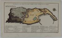
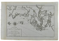
1750177186circa1750. Hand-coloured engraving 19.5 x 35.6 cm 25.5 x 41.6 cm sheet original folds two old paper repairs not affecting the image a trifle toned but in very good condition Attractive bird's-eye view town plan of Makassar in Sulawesi prepared for Abbé Prevost's monumental 'Histoire Générale des Voyages.' . unknown
179521089Brest 1795 1 feuillet avec en-tête préimprimé en noir : Liberté Egalité Fraternité et orné d'une vignette en noir (avec symboles révolutionnaires : faisceaux d'Armes et bonnet Phrygien et marianne), manuscrit à l'encre brune sur papier vergé bleuté ligné filigrané, format 19,8 centimètres de large par 31,5 centimètres de haut, Lettre écrite à ROCHEFORT, le 9 Prairial, An 3, de la République Française, une et indivisible, signature manuscrite de LELARGE,
179521092Brest 1795 1 feuillet avec en-tête préimprimé en noir : Liberté Egalité Fraternité et orné d'une vignette en noir (avec symboles révolutionnaires : faisceaux d'Armes et bonnet Phrygien et marianne), manuscrit à l'encre brune sur papier vergé crème ligné filigrané, format 18 centimètres de large par 24 centimètres de haut, Lettre écrite à ROCHEFORT, le 13 Germinal, An 3, de la République Française, une et indivisible, signature manuscrite de LELARGE,
1784174895London.: Alexander Hogg at the King's Arms. circa1784. Engraved map on laid paper 21.4 x 33.7 cm inset of Gower's Simson's and Carteret's Island early outline hand colour trimmed to the plate mark at the top edge three small edge tears affecting the upper margin only slight paper toning but a most attractive map in very good condition. Fine impression of the Queen Charlotte's Islands Solomon Islands. It features the Swallow's track the ship's route taken by Captain Philip Carteret in 1767 the British naval officer and explorer who participated in two of the Royal Navy's circumnavigation expeditions in 1764–66 and 1766–69. . Alexander Hogg at the King's Arms. unknown
175692353Thomas Baskett. London. 1756. First edition. 1756. 36 pages with title page not bound but held together with paper clips. Page edges very chipped last blank page lacks portions and is very torn and worn. Stain to top of title. Was originally folded in half so paper clip marks are visible to right margin of title. SCARCE. unknown