55 résultats
174019595(Augsburg), Matthäus Seutter, um 1740. Ca. 50 cm x 58 cm (Platte).
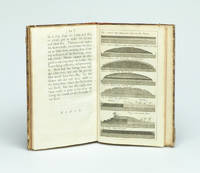
173729354London Gilliver and Clarke 1737. 8vo. Near contemporary half calf with gilt title label. 16622 pp. and 8 engraved plates 1 folding. 4cm tear to bottom of title page - proffesionally repaired with no loss. A fine clean copy. <br/><br/><em>First edition. Phillips recognized that a layer of gravel if resting on a well-drained dry sole would be beaten by the traffic into a firm road surface. He was thus the pioneer in the development of the Macadam method. The present work is described in Gregory: The Story of the Road p.207-211. Very uncommon. </em> unknown
173729354London, Gilliver and Clarke, 1737. 8vo. Near contemporary half calf with gilt title label. (16),62,(2) pp. and 8 engraved plates (1 folding). 4cm tear to bottom of title page - proffesionally repaired with no loss. A fine clean copy.
1796209283London.: George Nicol. 1796. Engraved copperplate map on Whatman paper 43.8 x 33.6 cm; 57 x 42 cm sheet including plate markscale in nautical and English miles; light undulation to sheet marginal toning and edgewear but in very good condition. Finely engraved and detailed map of two routes to Pekin Beijing along the White River Baihe from the Gulf of Petcheli and along the Imperial Highway from Jehol and includes commentary locating palaces and gardens type of cultivation "many barges" and "the road shaded by willow trees". The map elegantly drawn by Henry William Parish was published in George Staunton's account of Earl Macartney's embassy to China 1792-1794. . George Nicol. unknown
1766016077London: Printed for S. Crowder 1766. Book. Very Good. Hardcover. The Second Edition. Folio 21 x 32cm. The second edition with additions and improvements; pp. iv 45 iii publisher's adverts; engraved frontispiece map of the world five further engraved plates of maps and one engraved plate of globes ten engraved figures and diagrams within the text. Contemporary half textured calf binding with marbled paper boards expertly restored with a new spine in matching style re-corned. contents clean and tight a few small marks/reading wear; frontispiece plate with a couple of short edge-tears expertly and inconspicuously repaired a few corners re-tipped. A very good well-presented copy. Scarce. Printed for S. Crowder Hardcover
1739174921London.: The Gentleman's Magazine. circa1739. Engraved map 22.2 x 31.4 31.1 x 33 cm sheet size elaborate explanatory key in three columns at the foot original folds sealed 2 cm tear to the lower part of the inner margin one other small fold tear no loss inner margin of the key trimmed with some loss an original fault paper browned and spotted on the verso but an historic map in good condition. . [The Gentleman's Magazine]. unknown
175692353Thomas Baskett. London. 1756. First edition. 1756. 36 pages with title page not bound but held together with paper clips. Page edges very chipped last blank page lacks portions and is very torn and worn. Stain to top of title. Was originally folded in half so paper clip marks are visible to right margin of title. SCARCE. unknown
1774174260A Paris.: Chez Saillant et Nyon rue Saint-Jean-de-Beauvais Chez Panckoucke Hotel de Thou rue des Poitevins. 1774. Engraved map on laid paper 27.2 x 19.9cm 26.5 x 22.2cm sheet size edge fold slight marginal toning but in very good condition. Map of the treacherous coastal waters sandbars submerged rocks and reefs surrounding Mindanao and the Joseph Freewill Islands Mapia Atoll in the Philippines finely re-engraved for the French edition of Captain James Cook's First Voyage 1768-1771 "Relation des voyages.pour faire des decouvertes dans l'hemisphere meridional et successivement executes par le commodore Byron le capitaine Carteret le capitaine Wallis & le capitaine Cook.". . Chez Saillant et Nyon, rue Saint-Jean-de-Beauvais, [Chez] Panckoucke, Hotel de Thou, rue des Poitevins. unknown
1749136827Paris. Circa1749. Engraved map on watermarked laid paper 20 x 27.3 cm of Fuzhou and coastline of Fujian Province original folds designed by the great French cartographer Jacques-Nicolas Bellin. This map is from the impressive 15-volume "Histoire Génèrale des Voyages" compiled by Antoine François Prévost map no. 2 Vol. 6. This map shows the estuary of Yangtze River Rivière de Chang. Very light browning on sheet edges but in very good condition. . unknown
1749136826Paris. circa1749. Black and white engraved map on watermarked laid paper 20.9 x 32.7cm showing coastal area of Zhejiang Province Province de Che-kiang including Zhoushan Archipelago Isle de Chusan Zhoushan Bay Bay de Chusan and Xiangshan County Siang-chan-luen a walled city outside of upper border Ningbo Ning-po prefecture under Qing administration title cartouche lower left original folds. This map is No. 3 Vol. 6 from the impressive 15-volume "Histoire Generale des Voyages" compiled by Antoine François Prévost. Even browning mainly to the sheet edges in very good condition. . unknown
1749136795Paris. circa1749. Black and white engraved map of Quanzhou and Zhangzhou 21.1 x 30 cm here spelled Chin-chew and Chang-chew and both final words with added superscript "ou" on watermarked laid paper 25.6 x 38 cm original folds a few marginal spots simplified compass rose and a decorative fleur de lis bottom right in very good condition. Attractive map including the estuary of Quanzhou River Xiamen Emowi and Kinmen or Quemoy Quemowi island. The map was designed by the eminent French cartographer Jacques-Nicolas Bellin and here published as plate No. 22 in the impressive 15 volume compilation of voyages "Histoire Generale des Voyages" by Antoine François Prévost. . unknown
1749136781Paris. circa1749. Black and white engraved map on laid paper showing entrance to Pearl/Canton river Macao and the area which would become Hong Kong Sinn-gan-hien folded designed by the prominent French cartographer Jacques-Nicolas Bellin. This map is No. 16 Vol. 5 from the impressive 15-volume "Histoire Generale des Voyages" compiled by French novelist Antoine François Prévost. The walled city of Canton upper section is divided into areas of Tartar and Chinese. <br> <br>Some light even browning on paper added at margins good copy. Map measures 25.7 x 20.5. . unknown
180057070c1800. Copper engraving with handcolouring map shows Germany and parts of France Italie Hongrie Pologne and Prusse sic. Minor hole upper border few closed tears and some browning edges otherwise a clean and bright image. Map measures approximately 34 x 46cm. . unknown
1703176390Amsterdam. circa1703. Engraved map on watermarked laid paper 16.5 x 26.5 cm plate-mark 26 x 42 cm sheet key in German inset detail of grave sites on the island of "Rhenee" Rineia and Apollonian relics lower corner creased and with a sealed tear to the verso no loss in very good condition. Fine engraving with large margins of the Greek island of Delos of great significance to classical antiquity and the mythological birthplace of the Greek deities Artemis and Apollo. . unknown
1781814581781 A Salomopolis, chez Androphile, à la Colonne inébranlable. 1781. Seconde édition retouchée par le Fr. Circonspect. 1 vol in-8 ( 20x12 cm), broché ( brochage d'époque), étiquette de titre collée au dos. 546 pages. PHOTOS SUR DEMANDE
17918128in-folio, 1 p. imprimée et complétée à la main, signature autographe de Sombreuil, en date du 28 août 1791 ; elle accompagnait le Brevet nominatif du bénéficiaire, invalide resté anonyme ; "ayant demandé à se retirer à Pont-à-Mousson et partant aujourd'hui de l'Hôtel...", l'intéressé a reçu quatre livres pour son trajet, à raison de huit sous par lieue pour dix lieues ; mention en dessous et au verso de divers versements qu'il a reçus à Meaux, Châlons, Château-Thierry, Saint-Dizier et Toul.
179725649chambery 1797 1 document original sur papier velin crème ligné : FEUILLE DE ROUTE POUR JULIEN LAURENT [NATIF DE NANTES], BRIGADIER AU 7EME RÉGIMENT DE HUSSARDS COMPAGNIE N°7 PARTANT DE CHAMBÉRY POUR SE RENDRE A NANTES DÉLIVRÉE PAR CLAPIER : COMMISSAIRE DES GUERRES DE CHAMBERY DU 26 FRUCTIDOR AN V, format : 38,5 x 28 cm, préimprimé en noir et manuscrit à l'encre brune de deux pages, avec notés la liste des arrets dans les villes traversées avec signatures , cachet noir de la présidence de l'autorité municipale de Nantes gravé en noir, + 1 document original sur papier velin bleu ligné : CERTIFICAT DE VISITE ET CONGÉ ABSOLU POUR CAUSE DE BLESSURES [CERTIFICAT DE RÉFORME] DÉLIVRÉ PAR L'ARMÉE DES ALPES - HÔPITAL MILITAIRE D'AIX DU 17 FRUCTIDOR AN V (3 SEPTEMBRE 1797) SIGNÉ CLAPIER, format : 25 x 38 cm, certificat détaillé et signé côté Nantais par l'Autorité Municipale de Nantes (avec cachet illustré en noir et signature de CHEVY Ainé, Administrateur Municipal de la Commune de Nantes),
1748175859Leipzig.: Schwabe Johann Joachim. 1748. Engraved map on laid paper 20.5 x 36 cm plate -mark inc. captions 24 x 39 cm sheet size original fold later hand-colouring slight marginal spotting but in very good condition. Fine 18th century ground plan of Gorée Island off the coast of Senegal infamous for its association with slavery. The map shows encampments and forts with a detailed key. Originally published in Abbe Prevost's "Histoire générale des voyages." 1746 -1789 with maps and plans by the great cartographer Jacques-Nicolas Bellin this was prepared for volume two of the the German edition "Allgemeine Historie der Reisen." published in 1748. . (Schwabe, Johann Joachim) unknown
176320307Lyon, Benoit Duplain, 1763 (marque gravée au titre) ; in-8 (200 mm), veau marbré, dos à nerfs décoré et doré, pièce de titre grenat, tranches rouges (reliure de l’époque) ; XXIV, 496 pp.
1750136782circa1750. Black and white copperplate engraving map of Java a little light even browning neat colour pencil highlighting of rivers and two settlements. Folded as issued. Good copy. 26 x 44cm. Issued in Prevost's Histoire Générale des Voyages ou nouvelle collection de toutes les relations de voyages par mer et par terre. . unknown
1720180201A Leide. Leiden.: Chez Pierre van der Aa. circa1720. Engraved panorama on watermarked laid paper 28.5 x 77.5 including captions; 31 x 79.5 cm sheet title cartouche engraved key in French and Dutch the upper margin trimmed to the platemark original folds edgewear and toning neat sealed tear to the outer edge barely visible 5mm intrusion to the image a very good dark impression. Finely composed and engraved panorama of Tokyo prepared for the monumental work "Galerie Agreable du Monde" by the master Dutch publisher Pieter Van de Aa 1659-1733. The detailed key in Dutch and French notes myriad buildings and temples on the horizon and in the foreground two processions converge: of nobles and their attendants dancers a trio of dogs and a priest or religious attending a suppliant. <br> <br>Pieter van der Aa 1659-1733 was born in Leiden Holland and started his own book publishing business when he was only twenty-three. His prolific output of highly decorated maps and atlases culminated in his magnum opus “Galerie Agreable du Monde” which illustrated the world known to Europeans in the early eighteenth century. Comprising 66 volumes it was the of plates published at that time it has been estimated that only 100 copies were published. . Chez Pierre van der Aa unknown
1796176602circa1796. Engraved map 18.3 x 22 cm 21.7 x 27 cm sheet original folds age toning and some offsetting inner edge darkened and discoloured but the map in good condition. Finely engraved map showing Ireland divided into counties lower coast of Scotland and Wales and the Isles of Man and Anglesea; also noting Nymph Bank 'discovered in 1735 by Capt. Doyle.' . unknown
17992111902160200187Washimi Tamotsu 1799. Soft Cover. Fine. Number of books: 1 book Washimi Tamotsu paperback
177322841Londres Robert Sayer 1773 une carte géographique dépliante entoilée saumon, CARTE D'EPOQUE, format plié : 16 x 22 cm, format déplié : 84 x 90 cm, Publié à Londres par Robert Sayer en 1773 et gravé par J. Gibson, il s'agit d'un bon exemplaire de la "Carte des routes de l'Europe de John Rocque". Rocque fut l'un des cartographes les plus importants de son époque. tissu et disséqué en vingt-quatre sections et conserve son étui d'origine la carte mesure 84 x 90 cm. avec une coloration à la main originale, la carte est en bon état, L'etui d'Epoque (16 x 22 cm) recouvert de papier marbré peigné orange est orné en son centre (partie haute) d'une pièce de titre sur fond vert avec roulette "or" en encadrment, titre doré "ROUTES D'EUROPE", plats et dos de l'étui dans un encadrement d'une roulette "or", l'or à terni légèrement mais l'étui est superbe, Bel exemplaire finement aquarellé à l'époque. 1773 Londres Robert Sayer Editeur,
1751177606Paris. 1751. Engraved map 48 x 52.2 cm; 51 x 67.6 cm sheet provinces highlighted with outline hand-colour elaborate title cartouche central fold small tear at the foot affecting the border old paper repair on the verso affecting the margin only pin-holes to the four marginal corners margins a little browned and dusty a handsome map in good condition. Fine large format map showing China Korea Taiwan and parts of Central Asia prepared for De Vaugondy's "Atlas Universel". The beautifully foliated cartouche features a duo of joyful Chinese musicians one dancing and a diminutive figure holding a parasol. <br> <br>From the Estate of the late collector and scholar Arthur Hacker. . unknown