VAUGONDY, ROBERT DEBiblio.com
55 résultats
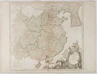
1751177606Paris. 1751. Engraved map 48 x 52.2 cm; 51 x 67.6 cm sheet provinces highlighted with outline hand-colour elaborate title cartouche central fold small tear at the foot affecting the border old paper repair on the verso affecting the margin only pin-holes to the four marginal corners margins a little browned and dusty a handsome map in good condition. Fine large format map showing China Korea Taiwan and parts of Central Asia prepared for De Vaugondy's "Atlas Universel". The beautifully foliated cartouche features a duo of joyful Chinese musicians one dancing and a diminutive figure holding a parasol. <br> <br>From the Estate of the late collector and scholar Arthur Hacker. . unknown
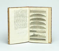
1766016077London: Printed for S. Crowder 1766. Book. Very Good. Hardcover. The Second Edition. Folio 21 x 32cm. The second edition with additions and improvements; pp. iv 45 iii publisher's adverts; engraved frontispiece map of the world five further engraved plates of maps and one engraved plate of globes ten engraved figures and diagrams within the text. Contemporary half textured calf binding with marbled paper boards expertly restored with a new spine in matching style re-corned. contents clean and tight a few small marks/reading wear; frontispiece plate with a couple of short edge-tears expertly and inconspicuously repaired a few corners re-tipped. A very good well-presented copy. Scarce. Printed for S. Crowder Hardcover
17918128in-folio, 1 p. imprimée et complétée à la main, signature autographe de Sombreuil, en date du 28 août 1791 ; elle accompagnait le Brevet nominatif du bénéficiaire, invalide resté anonyme ; "ayant demandé à se retirer à Pont-à-Mousson et partant aujourd'hui de l'Hôtel...", l'intéressé a reçu quatre livres pour son trajet, à raison de huit sous par lieue pour dix lieues ; mention en dessous et au verso de divers versements qu'il a reçus à Meaux, Châlons, Château-Thierry, Saint-Dizier et Toul.
179917589A Paris, chez Jean ; gravé sur une feuille pliante (55,5x86cm), colorié, qui doit dater de juste avant l'avénement de l'Empire car il y a encore le «quay Bonaparte». On relève aussi les rues d'Arcole, du Contrat Social, du Caire, et, plus curieux, l'existence encore signalée du Palais du Conseil des 500 pourtant dissous le 9 novembre 1799.
173729354London, Gilliver and Clarke, 1737. 8vo. Near contemporary half calf with gilt title label. (16),62,(2) pp. and 8 engraved plates (1 folding). 4cm tear to bottom of title page - proffesionally repaired with no loss. A fine clean copy.
173729354London Gilliver and Clarke 1737. 8vo. Near contemporary half calf with gilt title label. 16622 pp. and 8 engraved plates 1 folding. 4cm tear to bottom of title page - proffesionally repaired with no loss. A fine clean copy. <br/><br/><em>First edition. Phillips recognized that a layer of gravel if resting on a well-drained dry sole would be beaten by the traffic into a firm road surface. He was thus the pioneer in the development of the Macadam method. The present work is described in Gregory: The Story of the Road p.207-211. Very uncommon. </em> unknown
1781814581781 A Salomopolis, chez Androphile, à la Colonne inébranlable. 1781. Seconde édition retouchée par le Fr. Circonspect. 1 vol in-8 ( 20x12 cm), broché ( brochage d'époque), étiquette de titre collée au dos. 546 pages. PHOTOS SUR DEMANDE
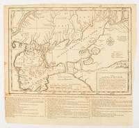
1739174921London.: The Gentleman's Magazine. circa1739. Engraved map 22.2 x 31.4 31.1 x 33 cm sheet size elaborate explanatory key in three columns at the foot original folds sealed 2 cm tear to the lower part of the inner margin one other small fold tear no loss inner margin of the key trimmed with some loss an original fault paper browned and spotted on the verso but an historic map in good condition. . [The Gentleman's Magazine]. unknown
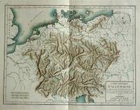
180057070c1800. Copper engraving with handcolouring map shows Germany and parts of France Italie Hongrie Pologne and Prusse sic. Minor hole upper border few closed tears and some browning edges otherwise a clean and bright image. Map measures approximately 34 x 46cm. . unknown
1776GF308981776 Paris - Ribou - 1776 - 1 volume in8 broché d'origine de papier gris avec titre imprimé sur une étiquette blanche "Route de Rouen par St Germain - Numéro 2" - 46 pages - minimes accrocs à la couverture -
1776GF308991776 Paris - Ribou - 1776 - 1 volume in8 broché d'origine de papier gris avec titre imprimé sur une étiquette blanche "Route de Beauvais - Numéro 3" - 47 pages -
1776GF309001776 Paris - Ribou - 1776 - 1 volume in8 broché d'origine de papier gris avec titre imprimé sur une étiquette blanche "Route d'Amiens - Numéro 4" - 70 pages - petit accroc en queue -
1777GF309041777 Paris - Ribou - 1777 - 1 volume in8 broché d'origine de papier gris avec titre imprimé sur une étiquette blanche "Route de S. Omer par Amiens et Arras - Numéro 9" - IV - 48 pages - (couverture un peu tachée au dos) -
1777GF309061777 Paris - Ribou - 1777 - 1 volume in8 broché d'origine de papier gris avec titre imprimé sur une étiquette blanche "Route de Noyon et Saint Quentin - Numéro 12" - IV - 71 pages -
1777GF309071777 Paris - Ribou - 1777 - 1 volume in8 broché d'origine de papier gris avec titre imprimé sur une étiquette blanche "Route du Havre - Numéro 7" - 58 pages - (notes au crayon sur la couverture ) -
17992111902160200187Washimi Tamotsu 1799. Soft Cover. Fine. Number of books: 1 book Washimi Tamotsu paperback
177322841Londres Robert Sayer 1773 une carte géographique dépliante entoilée saumon, CARTE D'EPOQUE, format plié : 16 x 22 cm, format déplié : 84 x 90 cm, Publié à Londres par Robert Sayer en 1773 et gravé par J. Gibson, il s'agit d'un bon exemplaire de la "Carte des routes de l'Europe de John Rocque". Rocque fut l'un des cartographes les plus importants de son époque. tissu et disséqué en vingt-quatre sections et conserve son étui d'origine la carte mesure 84 x 90 cm. avec une coloration à la main originale, la carte est en bon état, L'etui d'Epoque (16 x 22 cm) recouvert de papier marbré peigné orange est orné en son centre (partie haute) d'une pièce de titre sur fond vert avec roulette "or" en encadrment, titre doré "ROUTES D'EUROPE", plats et dos de l'étui dans un encadrement d'une roulette "or", l'or à terni légèrement mais l'étui est superbe, Bel exemplaire finement aquarellé à l'époque. 1773 Londres Robert Sayer Editeur,
176320307Lyon, Benoit Duplain, 1763 (marque gravée au titre) ; in-8 (200 mm), veau marbré, dos à nerfs décoré et doré, pièce de titre grenat, tranches rouges (reliure de l’époque) ; XXIV, 496 pp.
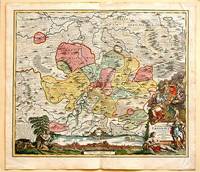
171761880Nuremberg.: Johann Baptist Homann. 1717. A beautifully engraved hand coloured map of North East Germany showing the area around Erfurt in detail. In the centre of the map is a small plan of Erfurt which is also shown as a panoramic view at the foot of the map and titled 'St. Petersburg'. An elaborate decorative title cartouche in the lower right corner depicts allegorical figures surrounded by the produce of the land including sheaves of wheat; a beehive; and a cornucopia of fruits. Cherubs holding a coat of arms float up from the scene on the right while on the lower left a centaur sits meditatively beneath a pine tree amongst slaughtered cattle. Physical features of the area are illustrated and farming areas shown by fields which criss-cross across the map. A clear dark impression the work of an outstanding German cartographer who in 1715 was appointed as imperial geographer by Emperor Charles VI. This map also includes "Schwan See" Swan Lake under a town of the same name which has since disappeared. Hand coloured two very minor splits at upper and lower edges on centre fold and not affecting engraved area a handsome map 54 x 61.5 cm. . [Johann Baptist Homann.] unknown
177051365Paris: Chez Le Rouge 1770. First edition . Oblong 4to. Engraved title leaf and seven engraved maps one folding the other six with a number of strip maps separated by thin rules detailing the route from Strasburg to Versailles. Delineates topographical features cities and villages churches forests etc. Not recorded on OCLC. Later patterned wrappers worn long tear in rear wrapper; interior soiled some old tidelines mostly marginal but affecting the image in the last two maps; several manuscript additions but a very good example of a scarce 18th-century French route map. <br/><br/> Chez Le Rouge unknown books
176837052Nueva impresión corregida 2ª Ed.- En Madrid: En la Imprenta de Andrés Ramírez con licencia Año MDCCLXVIII 1768.- 2 Vols. 16 h. 499 p.; 2 h. 708 p. i.e. 608 ya que por error se saltaron una centena; 4º menor 215 cm; Tela moderna hacia 1930 en color marfil con tejuelo rojo en lomo.- Este ejemplar es la 1ª reimpresión de esta obra en realidad la 2ª Edición y es tan apreciada como la primera ed. que constaba de 3 tomos y se publico en 1748.- MUY RARO. Palau Nº 84422. La página 195 del tomo 1º con un trozo del margen superior restaurado sin afectar texto y pequeñas marcas de humedad en el margen superior de 13 hojas sin que lleguen a tocar la impresión. Da la sensación de que faltan las portadillas aunque los ejemplares que hemos podido cotejar tienen esa misma particularidad ver Google Books o el ejemplar de la Biblioteca Nacional de España. SIGLO XVIII ESPAÑOL Libro en español En la Imprenta de Andrés Ramírez hardcover
178653148Madrid: Por don Antonio de Sancha 1786. First edition small 4to pp. 12 400; contemporary full vellum manuscript title faded on spine; very good and sound. Three copies in OCLC as of 1/19 only one Dominican House of Studies in the US. Palau 41034. Por don Antonio de Sancha unknown
17865210Madrid: Don Antonio de Sancha 1786. Sm. 4to. 12400pp. Cont. limp vellum somewhat soiled hand lettered spine with a few small chips. Old faded water stains throughout & a blue oval library stamp on title page partially obscuring the text beneath it. Palau 41034. Don Antonio de Sancha hardcover books
178653148Madrid: Por don Antonio de Sancha 1786. First edition small 4to pp. 12 400; contemporary full vellum manuscript title faded on spine; very good and sound. Three copies in OCLC as of 1/19 only one Dominican House of Studies in the US. Palau 41034. <br/><br/> Por don Antonio de Sancha hardcover books
1774174260A Paris.: Chez Saillant et Nyon rue Saint-Jean-de-Beauvais Chez Panckoucke Hotel de Thou rue des Poitevins. 1774. Engraved map on laid paper 27.2 x 19.9cm 26.5 x 22.2cm sheet size edge fold slight marginal toning but in very good condition. Map of the treacherous coastal waters sandbars submerged rocks and reefs surrounding Mindanao and the Joseph Freewill Islands Mapia Atoll in the Philippines finely re-engraved for the French edition of Captain James Cook's First Voyage 1768-1771 "Relation des voyages.pour faire des decouvertes dans l'hemisphere meridional et successivement executes par le commodore Byron le capitaine Carteret le capitaine Wallis & le capitaine Cook.". . Chez Saillant et Nyon, rue Saint-Jean-de-Beauvais, [Chez] Panckoucke, Hotel de Thou, rue des Poitevins. unknown