4 345 résultats
1402080964.Ghardcover. Good. Access codes and supplements are not guaranteed with used items. May be an ex-library book. hardcover
1475779135.Gpaperback. Good. Access codes and supplements are not guaranteed with used items. May be an ex-library book. paperback
2004SONG1402080964Springer 2004-06-15. 2004. hardcover. Used: Good. 6.24x0.76x9.50. Buy with confidence. Excellent Customer Service & Return policy. Springer hardcover
2004DADAX1402080964Springer 2004-06-15. 2004. hardcover. New. 6.24x0.76x9.50. Buy with confidence. Excellent Customer Service & Return policy. Springer hardcover
ria9781402080968_inpHardcover. New. New Book; Fast Shipping from UK; Not signed; Not First Edition; Palmprint Authentication is the first book to provide a comprehensive introduction to palmprint technologies. It reveals automatic biometric techniques for personal identification using palmprint from the approach based on offline palm hardcover
ria9781475779134_inpPaperback. New. New Book; Fast Shipping from UK; Not signed; Not First Edition; Palmprint Authentication is the first book to provide a comprehensive introduction to palmprint technologies. It reveals automatic biometric techniques for personal identification using palmprint from the approach based on offline palm paperback
19912090502113716694Not Available 1991. Soft Cover. Fine. The book is in fine condition. Not Available paperback
20082111902153101033power life 2008. Soft Cover. Fine. Volume: 1 power life paperback
1875243423Standing Rock 1875. unbound. Partly printed military document signed 6th Infantry seven months before Little Big Horn 16.75 x 10.75 inches Standing Rock Nov. 1 1875 "A Statement Of Forage and Straw Issued to and Consumed by the Public Animals under my direction at Standing Rock Dakota Territory during the month of October 1875" for transient animals from Fort Rice signed by Captain and Commander of Post James S. Poland an officer who served under Major Reno at the Little Big Horn and was erroneously reported as "Killed In Action" when severely wounded in the back. At the time this document was signed Poland was ordered to cease his sale of rifles and ammunition to Indians at the Standing Rock Reservation as the recipients were closely connected with Sitting Bull's band. One month later the Commissioner of Indian Affairs called for the use of troops against those Indians. Also signed by Lieutenant William Badger a close friend of Custer who survived the Black Hills Campaign. His son Tom who filled out the body of this document became General Custer's personal secretary in 1876 and was killed at Little Big Horn. Also included: a Xerox of a rare photograph of the 7th cavalry 6th infantry in uniform with accoutrements all identified including Custer Badger and Poland. Partial tearing along one of the folds; otherwise near fine condition.<br/><br/> unknown books
2013x-1475779135Springer 2013. Paperback. New. 253 pages. 9.25x6.10x0.58 inches. Springer paperback
27254Paris Chez Vincent 1768 in 12 (14,5x8,5) 1 volume reliure plein veau fauve marbré de l'époque, dos lisse orné, pièce de maroquin rouge, tranches teintées rouge, XX et 280 pages, coiffes et coins légèrement usés. Rare. Bon exemplaire ( Photographies sur demande / We can send pictures of this book on simple request )
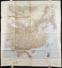
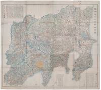
1945206545Calcutta: Compiled and drawn by the Survey of India. Second Edition. 1945. Large folding colour map 77.5 x 80cm; 95.5 x 86.2cm sheet including legend and small inset showing adjoining maps light toning and wear to upper margins and at corners and folds; but in very good condition. Very large clear map of China printed in 1945. The projection is noted as the "Lambert Conical Orthomorphic" a polyconic projection employed by the exhaustive Survey of India and the map includes surrounding countries: Taiwan Korea French Indo-China with a small inset key to Korean place-name abbreviations. As is typical of maps of this period Arunachal Pradesh is shown as Tibetan territory.The legend lists borders and provinces railways roads and canals with topography indicated with colouration. . Compiled and drawn by the Survey of India. unknown
1894177068Chicago.: Geo. F. Cram. 1894. Chromolithographed maps 54.3 x 34.1 cm sheet central fold a few small edge tears and marginal age toning but in very good condition. Detailed maps prepared for George F. Cram's 1894 "Standard American Atlas": one of the first American firms to publish a world atlas. Maps of Oceania and South Africa printed on the verso. . Geo. F. Cram. unknown
1877177229New York.: Ivison Blakeman Taylor & Co. circa1877. Printed colour map 27.5 x 21.7 cm large inset of Northern Africa and a smaller of Southern Africa two small edge tears lower corner neatly strengthened the sheet toned but the map in good condition unrelated text printed on the verso. Map of Africa as a whole before the Imperial race for colonies in the 1880s with interesting insets of Northern and Southern Africa. . Ivison, Blakeman, Taylor & Co. unknown
1895175108London.: Times Atlas of the World. 1895. Double-page folding map printed in colour 46.5 x 36.5 cm. edges gilt central fold with an inset map of Somaliland Somalia and the island of Sokotra key to European possessions outlined in colour small edge fold tears affecting the margin only and two other small edge tears slight toning at the edgaes but in very good condition. Attractive and detailed map prepared for the first edition of "The Times Atlas of the World". . (Times Atlas of the World). unknown
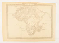
1880174956London.: The London Printing and Publishing Company. Circa1880s. Printed map 24 x 32.1 cm decorative border two original vertical folds paper toned mainly at the edges inner margin of the sheet ragged but in good order. A late edition of the map used for the well-known Tallis map this without the characteristic vignettes and on thinner paper. . The London Printing and Publishing Company. unknown
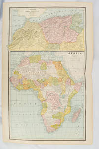
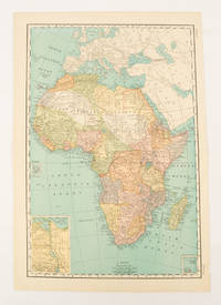
1899174902New York.: Rand McNally & Co. 1899. Printed colour map 36.3 x 24.3 cm inset map of the Suez Canal and two smaller insets of the Cardagos Crayos Islands Mascarene Islands and Cape Verde Islands central fold and on the verso a printed panel listing the countries in Africa with their territorial governance area and population lower corner creased at the outer margin but in very good condition. An interesting late nineteenth-century map noting colonial governance. . Rand, McNally & Co. unknown
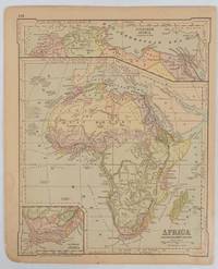
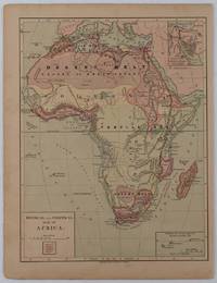
1877176015New York.: Harper & Brothers. circa1877. Chromolithographed map with outlne handcolour 27.1 x 21 cm major towns marked with a red cross relief by hachures ocean currents marked two inset maps of the Suez canal and Mascarene Island two very small marginal edge tears not affecting the map slight toning unrelated text on the verso prepared for "Harper's School Geography" in very good condition Interesting map of Africa before the escalation of the European race for colonial possessions from 1880. The map shows: the European possessions of the Cape Colony Transvaal Republic Orange River Republic and Natal; regions of the continent as fertile belts and desert belts; and indicates agricultural and other production such as palm oil ivory skins and cattle. Major cities are shown with important trade centers highlighted with a red cross. Prepared for US students in "Harper's School Geography" longitude is shown from the Greenwich prime meridian at the head of the map and from the Washington prime meridian at the foot. A small outline map of Ohio is included for relative scale. . Harper & Brothers. unknown
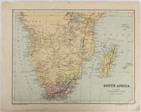
1877177228Edinburgh & London.: W. & A. K. Johnston. circa1877. Printed colour map 25 x 32.5 cm edge tears one affecting the lower border only two small chips from the upper margin corner repaired the map in very good condition. Map of North America with a small inset of the British Isles on the verso. Map of Southern Africa before the Scramble for Africa in the late 19th Century. . W. & A. K. Johnston. unknown
1418159850Shūseidō 衆星堂. Reprint. Tenpō 14 1843. Large folding handcoloured map of the thirteen provinces from which Mt. Fuji can be viewed. 159 x 178cm. Folds into paper covered card covers measuring 40 x 24cm. Title label upper cover. A little browning along folds occasional spotting and soiling. A little worming causing approximately 1cm of loss in places. Two chops in lower section. A very striking and attractive map. This very large handsome map is a detailed map of the thirteen provinces from which one can see Mt. Fuji. Provinces shown are the eight provinces of the Kantō region Sagami 相模 Musashi 武蔵 Kazusa 上総 Shimofusa 下総 Awa 安房 Kōzuke 上野 Shimotsuke 下野 and Hitachi 常陸 and five other provinces Izu 伊豆 Suruga 駿河 Tōtōmi 遠江 Kai 甲斐 and Shinano 信濃. The map offers a large amount of detailed information such as province and county borders rivers high ways post towns checkpoints villages and scenic spots. <br> <br>The cartographer Akiyama Einen or Nagatoshi 秋山永年 came from Edo and the editor Funakoshi Seizō 船越清蔵 studio name: Shugu 守愚 1805-62 a Confucian scholar from Nagato Province now the western half of present-day Yamaguchi Prefecture. A dedication by Funahashi Akira 舟橋徴 is dated 1843. . Shūseidō 衆星堂 unknown
192063120Chicago: White Pass & Yukon Route Rathbun-Grant-Heller Co. ca. 1920. 8vo. 4 x 9 in. 16 pp. in 46 2 triple-column format on 9 x 12 in. sheets with numerous photo illustrations double-column route map w/ White & Pass & Yukon line logo. Self-printed softcovers beautiful cover art of Alaskan Native Americans in canoe watching a Yukon River steamer minor shelfwear some rubbing still VG copy. First edition thus of this very scarce travel brochure detailing the trip by steamship and railroad along the White Pass & Yukon Route from Skagway Alaska through Ketchikan Atlin Lake district and through the Skagway Valley to Dawson City on the Yukon River Yukon Territory. White Pass & Yukon Route, Rathbun-Grant-Heller Co., paperback
192846131Chicago: Poole Bros. Inc. 1928. Oblong 16mo. 59 1 pp. Photo illusts. 1 map. Photo-illust. self-printed wrappers slight shelfwear NF copy stapled as issued. First edition thus of this travel brochure detailing the trip by steamship and railroad along the White Pass & Yukon Route from Skagway Alaska to Dawson City on the Yukon River Yukon Territory. Poole Bros., Inc., unknown
2019LFA-126743236Une revue de 130 pages, format 210 x 270 mm, illustrée, brochée couverture couleurs, publié en 2019, bon état
1998LFA-126743632Une revue de 114 pages, format 230 x 300 mm, illustrée, brochée couverture couleurs, publié en 1998, bon état
2011LFA-126725722Une revue de 130 pages, format 210 x 270 mm, illustrée, brochée couverture couleurs, publié en 2011, bon état