Northern Cross Rail RoadBiblio.com
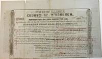
STATE OF ILLINOIS COUNTY OF McDONOUGH NORTHERN CROSS RAIL ROAD SUBSCRIPTION BOND ISSUED IN PURSUANCE OF AN ORDER OF THE JUDGES OF THE COUNTY COURT OF SAID McDONOUGH COUNTY PROVIDING FOR THE SUBSCRIPTION TO THE CAPITAL STOCK OF THE NORTHERN CROSS RAIL ROAD COMPANY . . . TWENTY YEARS AFTER DATE WE THE COUNTY OF McDONOUGH IN THE STATE OF ILLINOIS HEREBY PROMISE TO PAY TO THE NORTHERN CROSS RAIL ROAD COMPANY OR BEARER AT THE OFFICE OF THE FARMER'S LOAN AND TRUST COMPANY IN THE CITY OF NEW YORK ONE THOUSAND DOLLARS FOR VALUE RECEIVED WITHOUT DEFALCATION WITH INTEREST THEREON AT THE RATE OF EIGHT PER CENT PER ANNUM. "AND THE SAID COUNTY OF McDONOUGH DOTH ALSO AGREE TO TRANSFER TO THE HOLDER HEREOF ON THE FIRST DAY OF JANUARY IN THE YEAR 1868 . . . ON THE DELIVERY OF THIS OBLIGATION AND THE UNPAID INTEREST COUPONS TEN SHARES OF THE CAPITAL STOCK OF THE NORTHERN CROSS RAIL ROAD COMPANY OF ONE HUNDRED DOLLARS TO EACH SHARE
185438904Quincy IL: Patriot Office. Gibson & Warren Printers 1854. Folio broadsheet bond oblong 16-1/4" x 9-1/2." Old folds with a couple of short marginal fold splits no text affected. Printed in a variety of type fonts and styles. Very Good. Signed in ink by Thompson Chandler County Judge of McDonough County; Isaac Grantham County Clerk; N. Bushnell President of the Rail Road; and C.E. Lippincott State Auditor.<br /> <br /> The County is in West Central Illinois. The Rail Road one of the earliest Illinois Roads was operated by the State of Illinois until the late 1840s. It later merged with the Wabash Railroad. Patriot Office. Gibson & Warren, Printers unknown