[BURMA - MAP]Biblio.com
4 345 résultats
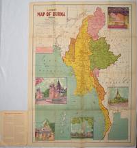
1951214601Delhi.: S.B. Makhija & Brothers. circa1951. Printed colour map 98.6 x 69 cms folding into pictorial wrappers 25.3 x 19.5 cms five pictorial colour inserts of pagodas and the Shwethalyaung reclining Buddha wrappers a little chipped marginal wear and three small fold splits in the map but overall in very good condition. Attractive large map of Burma with the provinces coloured steamship routes shown in red and printed in the booklet a range of information printed based on the 1951 census including climate agriculture and form of government "Burma became an independent nation completely outside the British Empire on January 4 1948 and is now a sovereign independent republic known as the Union of Burma". . S.B. Makhija & Brothers. unknown
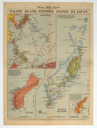
1944208880Chicago.: Chicago Daily Tribune. 28 September1944. Colour pictorial map on a single newspaper leaf archivally laid down on linen 50 x 39.2 cms; 59.3 x 43.3 cms sheet including captions faint toning to fold lines very good condition. Vivid colour maps of the Palau Islands Guam and Saipan in the Marianas and an inset location map published in the "Chicago Daily Tribune" in September 1944 months after the landing of US and Allied Forces in the offensive against the Japanese during the Pacific War. . Chicago Daily Tribune. unknown
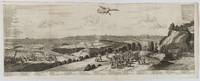
1720180201A Leide. Leiden.: Chez Pierre van der Aa. circa1720. Engraved panorama on watermarked laid paper 28.5 x 77.5 including captions; 31 x 79.5 cm sheet title cartouche engraved key in French and Dutch the upper margin trimmed to the platemark original folds edgewear and toning neat sealed tear to the outer edge barely visible 5mm intrusion to the image a very good dark impression. Finely composed and engraved panorama of Tokyo prepared for the monumental work "Galerie Agreable du Monde" by the master Dutch publisher Pieter Van de Aa 1659-1733. The detailed key in Dutch and French notes myriad buildings and temples on the horizon and in the foreground two processions converge: of nobles and their attendants dancers a trio of dogs and a priest or religious attending a suppliant. <br> <br>Pieter van der Aa 1659-1733 was born in Leiden Holland and started his own book publishing business when he was only twenty-three. His prolific output of highly decorated maps and atlases culminated in his magnum opus “Galerie Agreable du Monde” which illustrated the world known to Europeans in the early eighteenth century. Comprising 66 volumes it was the of plates published at that time it has been estimated that only 100 copies were published. . Chez Pierre van der Aa unknown
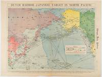
1942180751Chicago.: Chicago Daily Tribune. Friday June 51942. Printed colour map on a single newspaper leaf 37.5 x 53.2 cm; 44.7 x 59.8 cm sheet inset legend marginal browning and at the folds some undulation of paper and tide mark along lower section but in remarkably bright very good condition. Strategic map published in the Chicago Daily Tribune "The World's Greatest Newspaper" on June 5th 1942 two days after the Japanese attack on Dutch Harbor the site of the US army and navy bases in the Aleutians and as it transpired at the outset of the Battle of MIdway. The owner and proprietor of the Tribune Robert McCormick was staunchly against the United States entering the war and had firm views once it had occurred that American resources should not be used defending the British Empire. Famously the Tribune published the "Victory Program" Roosevelt’s military plan to prepare the United States for possible entry into World War II and was subject to prosecution for an alleged violation of the Espionage Act relating to the newspaper’s front-page account of the Battle of Midway 4-7 June 1942. It became an important test case for the limits of free speech and censorship during war-time. <br> <br>The Legend shows territorial Control of Ocean Areas marking Japanese Naval and Air bases as of 1941 and "according to latest reports" those established in the first six months of 1942. Also shown are pre-war sovereignties as at the bombing of Pearl Harbour on December 7th 1941. The Anson Archipelago is shown but a question mark "indicates islands etc. whose existence or give position is doubtful…". . Chicago Daily Tribune. unknown
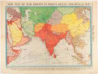
1942180782Chicago.: Chicago Daily Tribune. April 211942. Printed colour map on a single newspaper leaf 37.5 x 53.2 cm; 60 x 45 x 59.6 cm sheet marginal browning and at the folds but remarkably bright in very good condition. World War II map of Asia save for Japan showing British allies colonies and lines of supply and marking Japanese territorial occupation published in the Chicago Daily Tribune "The World's Greatest Newspaper" in April 1942. <br>"The Indian Ocean and the Bay of Bengal are the strategic waters in this campaign in which the occupied parts of Burma and the Andaman Islands serve as bases" caption <br>". the historic Chicago Tribune was an innovator in color inks and printing but also a pioneer in bringing colorful art in the form of illustrations photographs cartoons and advertisements to the average person in an everyday medium." see The Janet A. Ginsburg Chicago Tribune Collection Michigan State University Libraries. . Chicago Daily Tribune. unknown
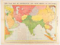
1942180760Chicago.: Chicago Daily Tribune. January 91942. Printed colour map on a single newspaper leaf 37.2 x 53.4 cm; 45 x 59.9 cm sheet inset legend marginal browning and at the folds lower margin with small edges tears not affecting the caption but remarkably bright in very good condition. Rare map of Asia "Between Suez on the west and Shanghai on the east" showing territorial interests and theatres of war published in the Chicago Daily Tribune in January 1942 barely two months after the Uniited States had joined the war effort after the bombing of Pearl Harbour. Thailand and Vietnam "French Indo-China" are marked "Occupied by the Japanese" and north-eastern China similarly marked Iran "Anglo-Russian Occupation" and the Gulf states "British Ally". The caption notes that "The map inludes waters thru which runs the British life line from the Suez canal to remote Australia and New Zealand. Nearly half the people in the world live in the lands shown on this map--more than 450 million for example in China and more than 375 million in India". <br> <br>". the historic Chicago Tribune was an innovator in color inks and printing but also a pioneer in bringing colorful art in the form of illustrations photographs cartoons and advertisements to the average person in an everyday medium." see The Janet A. Ginsburg Chicago Tribune Collection Michigan State University Libraries. . Chicago Daily Tribune. unknown
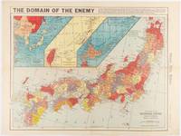
1941180789Chicago.: Chicago Daily Tribune. December 121941. Printed colour map on a single newspaper leaf 41.5 x 53 cm; 45.1 x 59.9 cm sheet three inset maps of the Japanese Empire; Taiwan and Ryukyu Islands; and Hokkaido and Chisima marginal browning and at the central fold but remarkably bright in very good condition. Map of the Japanese Empire ominously titled published in the Chicago Daily Tribune one week after the bombing of Pearl Harbour. Prefectures are attractively coloured. <br> <br>Based on a Rand McNally map the Tribune briskly got to work issuing maps for readers showing the beginnings of the war with Japan. Later maps were also published for sale separately but remarkably few have survived. <br>". the historic Chicago Tribune was an innovator in color inks and printing but also a pioneer in bringing colorful art in the form of illustrations photographs cartoons and advertisements to the average person in an everyday medium." see The Janet A. Ginsburg Chicago Tribune Collection Michigan State University Libraries. . Chicago Daily Tribune. unknown
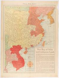
1519180794Chicago.: Chicago Daily Tribune. January 151942. Printed colour map on a single newspaper leaf 53 x 40.7 cm; 59.8 x 45 cm sheet inset text box marginal browning and at the folds but remarkably bright in very good condition. WWII map of China showing most of China Indo-China Thailand and Korea with territory captured and controlled by Japan shaded in orange and red published by the Chicago Daily Tribune barely six weeks after the bombing of Pearl Harbour. The text on the map reads "Since 1937 China has been at war with Japan. Lacking many essentials of war the Chinese nevertheless have managed to maintain a front against the aggressors. China's principal life line is the Burma road shown on the map which starts at Lashio Burma and extends to Kunming Yunnan province where it links with connections to Chunking the present Chinese capital". <br> <br>Based on a Rand McNally map the Tribune briskly got to work issuing maps for readers showing the beginnings of the war with Japan. Later maps were also published for sale separately but remarkably few have survived. <br>"… the historic Chicago Tribune was an innovator in color inks and printing but also a pioneer in bringing colorful art in the form of illustrations photographs cartoons and advertisements to the average person in an everyday medium." see The Janet A. Ginsburg Chicago Tribune Collection Michigan State University Libraries. . Chicago Daily Tribune. unknown
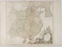
1751177606Paris. 1751. Engraved map 48 x 52.2 cm; 51 x 67.6 cm sheet provinces highlighted with outline hand-colour elaborate title cartouche central fold small tear at the foot affecting the border old paper repair on the verso affecting the margin only pin-holes to the four marginal corners margins a little browned and dusty a handsome map in good condition. Fine large format map showing China Korea Taiwan and parts of Central Asia prepared for De Vaugondy's "Atlas Universel". The beautifully foliated cartouche features a duo of joyful Chinese musicians one dancing and a diminutive figure holding a parasol. <br> <br>From the Estate of the late collector and scholar Arthur Hacker. . unknown
195676405San Jose: H.M. Gousha Co. on or before 1956. First edition of this gathering. Folio 13 1/4 x 18 inches. 62 unused road maps in color and with inserts each neatly divided by side tabs. All maps bound on stubs. Original red cloth portfolio with flap and snap fasteners the Shell logo stamped on front cover some soiling or darkening to extremities. The portfolio has some expected wear but the maps are fresh and clean. Shell maps of this era are notable for their high-quality cartography colorful graphics and often included travel tips local advertisements and information about Shell services. None located by OCLC. Harry Mathias Gousha a former Rand McNally went independent in 1926 and relocated to California in 1947. It was a propitious time as the 50s in most respects witnessed the onset of the great American phenomenon of the Road Trip. With the improvement in cars longer and longer trips became feasible. None of the great Interstates as we know them today were in existence at that time so road maps were essential for any successful road trip. The H.M. Gousha Company was one of the "Big Three" major producers of road maps and atlases in the United States during the 25 years following World War II General Drafting and Rand McNally were the other two. Shell maps of this era although free are notable for their high-quality cartography colorful graphics and often included travel tips local advertisements and information about Shell services. The H. M. Gousha Company produced millions of oil company road maps used as marketing tools distributed at no charge at gas stations by customers that included Gulf Oil Conoco Shell Standard Oil and dozens of others. Though most Gousha maps were produced for oil companies many others were issued for customers not related to the petroleum industry including automobile clubs state governments banks and realtors. Ironically the company was purchased by Rand McNally in 1996. H.M. Gousha Co. hardcover
18282111902160201307Itamoto's seal is also unknown 1828. Soft Cover. Fine. Volume: 1 Itamoto's seal is also unknown paperback
Trade paperback Very good. No dust jacket as issued. Light Wear on cover. Pages a ll intact, clean, no tear and no writings. Stock Photo different from actual book cover. Trade paperback (US). Glued binding. 533 p. Audience: General/trade.
SLIVCN-9781634853934NOVA SCIENCE PUBLISHERS INC (9/2016)
3006Milwaukee: The Company; Daily News Book and Job Steam Printing Office 1857. . 8vo yellow wrappers front printed This is not a later printing of Library of Congress Modelski No. 440. There is no inset and the copyright is 1856 Milwaukee: [The Company]; Daily News Book and Job Steam Printing Office, 1857. unknown
3006Milwaukee: The Company; Daily News Book and Job Steam Printing Office 1857. . 8vo yellow wrappers front printed This is not a later printing of Library of Congress Modelski No. 440. There is no inset and the copyright is 1856 Milwaukee: [The Company]; Daily News Book and Job Steam Printing Office, 1857. unknown books
19702091202133106272Ministry of Construction Road Bureau Kinki Regional Construction Bureau 1970. Soft Cover. Fine. Number of books: 2 Ministry of Construction Road Bureau Kinki Regional Construction Bureau paperback
1924015720Paris Au Sans Pareil 1924 In-12 Broché, couverture illustrée Edition originale
2003BN155401comedia-Verlag 2003. 2003. Hardcover. Das trikontinentale Solidaritätsplakat Deutsch / Spanisch / Englisch / Französisch <br/><br/>Das trikontinentale Solidaritätsplakat Deutsch / Spanisch / Englisch / Französisch Richard Frick Texte: Ulises Estrada Lescaille Nirta Muniz Reinaldo Morales Campos Jorge R. Bermúdez Alfredo G. Rostgaard Olivio Martinez Lázaro Abreu Padrón René Lechleiter comedia-Verlag hardcover
19992080302106809654Toei Kawagoe Road Residential Ruins Survey 1999. Soft Cover. Fine. Number of books: 6 Toei Kawagoe Road Residential Ruins Survey paperback
1981mon0000977443Ross Erikson 1981T. paperback. Very Good. 0.7008 in x 8.9016 in x 5.7008 in. Rubbing on front cover. Water marks on spine and small part of back cover. Ross Erikson paperback
1996DADAX0471960128Wiley 1996-04-19. 1. hardcover. New. 6.26x1.13x9.09. Buy with confidence. Excellent Customer Service & Return policy. Wiley hardcover
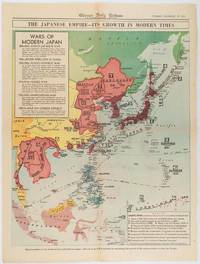
1619180755Chicago.: Chicago Daily Tribune. December 161941. Printed colour map on a single newspaper leaf 50 x 41.5 cm; 60 x 45 cm sheet two inset legends marginal browning and at the folds but remarkably bright in very good condition. Map of the Japanese Empire published in the Chicago Daily Tribune "The World's Greatest Newspaper" on December 16th 1941 9 days after the bombing of Pearl Harbour. The two legends list the "Wars of Modern Japan" from 1894 with territorial gains marked noting that "Each seizure of mainland areas has given Japan new field of raw materials." <br> <br>"… the historic Chicago Tribune was an innovator in color inks and printing but also a pioneer in bringing colorful art in the form of illustrations photographs cartoons and advertisements to the average person in an everyday medium." see The Janet A. Ginsburg Chicago Tribune Collection Michigan State University Libraries. . Chicago Daily Tribune. unknown
1986x-9061935431Dr W Junk Pub Co 1986. Hardcover. New. 406 pages. 11.34x8.58x1.10 inches. Dr W Junk Pub Co hardcover
Very Good English Original green cloth. Title gilt in black "Egyptian Touring Association" and "ETA logo" to the front board. Foolscap 8vo. (17,5 x 13 cm). In English. 110 p. with rich separate advertisements, and a fine folded b/w map titled "Desert motor-routes" on a scale of 1:4,000,000. Slightly fading on cloth, otherwise a fine copy. First and only edition of this rare complete and very detailed desert motor-routes' guide for the Anglo-Egyptian motorists, printed by the Egyptian Touring Association in Cairo, including details about hospitals, "what to do in cases of accidents on the roads", free legal defence, hotels, garages as well as itineraries, pedestrian crossings, speed limits in the country, parking regulations of Sharia Kasr el Nil, Adly Pasha, no-lights area, railway bridges, postal rates, exchange rates, rates of freight on motor cars by sea and rail, kilometers into miles, transcontinental road London - Istanbul with other useful information. This guide was explained in the introduction as "This handbook has been compiled for the benefit of members and is issued to them free. Extra copies may be obtained from the Head Office, 3 Sh. Cattawi Bey, Kasr el Nil, Cairo, at the price of P.T. 10. It contains a good deal of useful information regarding touring of all kinds in Egypt and abroad including a list of recommended hotels and garages throughout the country. "The president of the Association which was founded in 1932, was H.E. Sir Miles Lampson (1880-1964). He was a British diplomat who was appointed High Commissioner for Egypt and Sudan in 1934. As a result of the Anglo-Egyptian Treaty in December 1936, to which Lampson was a signatory, Britain loosened its grip on Egypt and the post title was changed to Ambassador to Egypt and High Commissioner for Sudan in 1936. Lampson continued in this office until 1946. Vice presidents were Sir Stenson Cooke and J. A. Crawford. According to the ETA's service page of the guide, the purpose of the association can be determined as "Association was formed to provide a long-felt want in Egypt, that is, a touring club in the true sense of the word, devoted to the interests of all kinds of travelers. It's a non-profit making co-operative organization with the aim of making the path of the motorist, the airman, the camper, and every other kind of traveler pleasanter and smoother. The E.T.A. is officially recognized by the Egyptian Government and already in its short existence has grown enormously, being able to offer the following very real services to its members: Expert and detailed advice on all touring matters. Expert advice on motoring matters and vetting of cars. Free itineraries to all parts of Egypt and abroad. Reminders are sent to all members when a car and driving license is due for renewal. Renewal of car and driving licenses. Free legal defense for motoring offenses. Triptyques, carnets, and all documents for foreign touring, including passport arrangements. Agents at Alexandria, PortSaid, Suez, and the principal ports to look after the incoming and outgoing motorist and relieve him of all worry. A full stock of maps and guide books of Egypt and other countries. Up-to-date information on the state of roads and desert tracks. Welcome and help from the 100 odd touring clubs of the A.I.T. [i.e. the Alliance Internationale de Tourisme], of which the E.T.A. is a member. Recommended hotels and garages throughout Egypt and the Near East. Insurance for members can be effected at the most advantageous rates, and advice is given. Cars can be driven to any part of Egypt, by experienced drivers. Guides are provided. Other benefits, it is hoped, will be given in due of course.". Not located in OCLC. "1938-39 Edition" of the series (not published more than two years) is located in OCLC in no. 862336537.
SLIVCN-9781634825948NOVA SCIENCE PUBLISHERS INC (6/2015)