4 345 résultats
1996__0471960128John Wiley & Sons Inc 1996. Hardcover. New. 1st edition. 375 pages. 9.50x6.25x1.00 inches. John Wiley & Sons Inc hardcover
194651162BB2 Bände. Buenos Aires, Editorial Losada, 1946. 8°. 265 S., 216 S. Originalbroschur mit Schutzumschlägen.
20122-9401047677Springer 2012. Paperback. New. reprint edition. 404 pages. 10.00x7.75x0.75 inches. Springer paperback
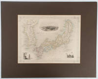
1850177528London.: The London Printing and Publishing Company. circa1850s. Lithographed map with original outline hand colour 25.8 x 33.5 cm three vignette illustrations decorative border central fold in very good condition presented in a window mount. Attractive decorative map with three vignettes by Rapkin: Yedo; a State barge in sail with penants flying--the paired oarsmen depicted through 10 small windows below deck; and Koreans in traditional costume; the map after the great mapmaker and publisher John Tallis. <br> <br>From the estate of the late collector and scholar Arthur Hacker with his pencilled catalogue mark on the verso. . The London Printing and Publishing Company. unknown
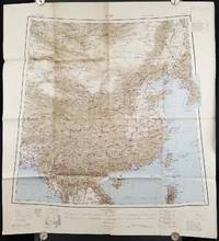
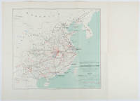
1945206545Calcutta: Compiled and drawn by the Survey of India. Second Edition. 1945. Large folding colour map 77.5 x 80cm; 95.5 x 86.2cm sheet including legend and small inset showing adjoining maps light toning and wear to upper margins and at corners and folds; but in very good condition. Very large clear map of China printed in 1945. The projection is noted as the "Lambert Conical Orthomorphic" a polyconic projection employed by the exhaustive Survey of India and the map includes surrounding countries: Taiwan Korea French Indo-China with a small inset key to Korean place-name abbreviations. As is typical of maps of this period Arunachal Pradesh is shown as Tibetan territory.The legend lists borders and provinces railways roads and canals with topography indicated with colouration. . Compiled and drawn by the Survey of India. unknown
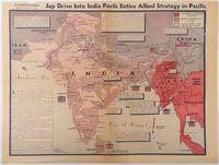
1944214362Los Angeles.: Los Angeles Examiner. April 31944. Colour pictorial map on a single newspaper leaf 37 x 50 cms; 41.5 x 54.6 cms sheet unrelated text on the verso although with an interesting account from a soldier's letter about an air raid in China toning more marked at the central fold two small splits no loss to the map edge wear with several small marginal edge tears neatly repaired on the verso with archival washi map unaffected in good condition. A dynamic map prepared and illustrated by the Examiner's art critic and editor Howard Burke covering the area surrounding India and Central Asia showing Japanese conquered territory in Malaya Thailand Indo-China and Burma; and in India British-controlled states and native feudal and protected states. <br> <br>Text boxes and pictographs give an overview of the geopolitical situation from the Allied perspective. One box notes "Chanda Bose has many adherents and fanatical followers in Bengal. They may prove to be a powerful fifth column in India". Text at lower edge opines "The situation in India is critical and has grown more so as the all-out offensive against Japan has been delayed. If the Allies do not act at once and with great force all our gains may be wiped out and the war in the Pacific prolonged indefinitely." <br> <br>The decisive and devastating bombings that were to signal such an end were four months away. <br> <br>Rare on the market. . Los Angeles Examiner. unknown
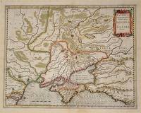
54794Amsterdam.: Jodocus Hondius. Circa Early 17th Century. Map depicting the southeastern part of present day Ukraine and the Crimean peninsula including the northern most part of the Black Sea and reaching north to Smolensk. Published by Hondius in the French edition of the Mercator-Hondius Atlas. Hand outline colour topographical detail shown pictorially some wear along centrefold occasional pale foxing mostly in margins decorative title cartouche upper right corner French text on verso showing through clear plate mark even age toning 48.5 x 58 cm. . [Jodocus Hondius]. unknown
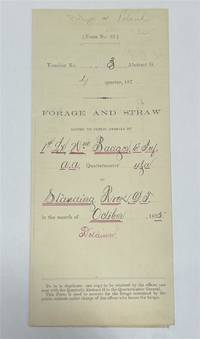
1875320963Standing Rock 1875. unbound. Partly printed military document signed 6th Infantry seven months before Little Big Horn 16.75 x 10.75 inches Standing Rock Nov. 1 1875 "A Statement Of Forage and Straw Issued to and Consumed by the Public Animals under my direction at Standing Rock Dakota Territory during the month of October 1875" for transient animals from Fort Rice signed by Captain and Commander of Post James S. Poland an officer who served under Major Reno at the Little Big Horn and was erroneously reported as "Killed In Action" when severely wounded in the back. At the time this document was signed Poland was ordered to cease his sale of rifles and ammunition to Indians at the Standing Rock Reservation as the recipients were closely connected with Sitting Bull's band. One month later the Commissioner of Indian Affairs called for the use of troops against those Indians. Also signed by Lieutenant William Badger a close friend of Custer who survived the Black Hills Campaign. His son Tom who filled out the body of this document became General Custer's personal secretary in 1876 and was killed at Little Big Horn. Also included: a Xerox of a rare photograph of the 7th cavalry 6th infantry in uniform with accoutrements all identified including Custer Badger and Poland. Partial tearing along one of the folds; otherwise near fine condition.<br/> <br/> unknown
1875243423Standing Rock 1875. unbound. Partly printed military document signed 6th Infantry seven months before Little Big Horn 16.75 x 10.75 inches Standing Rock Nov. 1 1875 "A Statement Of Forage and Straw Issued to and Consumed by the Public Animals under my direction at Standing Rock Dakota Territory during the month of October 1875" for transient animals from Fort Rice signed by Captain and Commander of Post James S. Poland an officer who served under Major Reno at the Little Big Horn and was erroneously reported as "Killed In Action" when severely wounded in the back. At the time this document was signed Poland was ordered to cease his sale of rifles and ammunition to Indians at the Standing Rock Reservation as the recipients were closely connected with Sitting Bull's band. One month later the Commissioner of Indian Affairs called for the use of troops against those Indians. Also signed by Lieutenant William Badger a close friend of Custer who survived the Black Hills Campaign. His son Tom who filled out the body of this document became General Custer's personal secretary in 1876 and was killed at Little Big Horn. Also included: a Xerox of a rare photograph of the 7th cavalry 6th infantry in uniform with accoutrements all identified including Custer Badger and Poland. Partial tearing along one of the folds; otherwise near fine condition.<br/><br/> unknown books
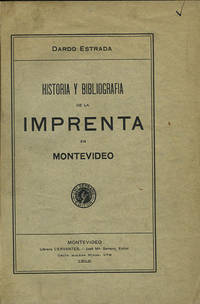
191235822Montevideo: Libreria Cervantes 1912. First edition. Cloth. A very good copy original wrappers lightly worn. 318 pp. Sm. 4to. Palau 84328. Jones 2829. Libreria Cervantes hardcover books
191235822Montevideo: Libreria Cervantes 1912. First edition. Cloth. A very good copy original wrappers lightly worn. 318 pp. Sm. 4to. Palau 84328. Jones 2829. Libreria Cervantes hardcover
1992047410Pachuca Mexico: Consejo de Recursos Minerales 1992 Book. As New. Hardcover. 1st US Ed. The state of Zacatecas is one of Mexico's most historically and economically significant mining regions often highlighted in specialized geological reports including this comprehensive Geological-Mining Monograph of the State of Zacatecas with its detailed text stratigraphic charts and geological maps often in 1:250000 scale that serve as a guide for exploration and academic study of this major mining region. Published by the Consejo de Recursos Minerales now part of the Mexican Geological Survey - SGM 155 p. illus charts col large format fold out maps in rear pockets. As new except for an ownerhip stamp NOTE : Very Heavy 1.5 kg/ large format volume. 35 x24 x24 cm. Consejo de Recursos Minerales hardcover
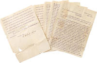
1901325474Central Valley N.Y. 1901. 5 pp. 4to. Some splitting at folds with minor loss more on last leaf. Fragile. 5 pp. 4to. Palma 1832-1908 was the president of the Cuban Republic in Arms during the Ten Years' War and the first President of Cuba between 1902-1906. He worked with José Martí to gather support for a revolution in Cuba and was the head of the Cuban Revolutionary party. He was elected while living in the United States at his homebase in Central Valley NY where he founded a multilingual co-ed private school licensed by New York State. <br /> <br /> Written to a newspaper during his presidential campaign the letter outlines the siutuation in Cuba and his hopes for the country. He was media-savy and used Hearst newspapers to spread his message and worked with the US Congress to pass a resolution renouncing the Spanish colonial hold on Cuba and announcing support for the creation of an independent Republic of Cuba. Upon his election in absentia at age 67 he returned to a Cuba from which he'd been effectively exiled a quarter-century before. He was elected to a second term in 1905 and died in 1908. unknown
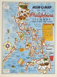
1945204557U.S.A.: Mem-O-Map Co. 1945. Colour pictographic / pictorial map 32.1 x 23.8 cms; 35.4 x 26.6 cms sheet very good condition. Rare pictorial map published in 1945 by John G. Drury aTechnical Officer who served with the 214th Ordnance Battalion to mark the end of World War II as souvenirs for the military. Military personnel could fill in banners "came in on good ship." and "departed on good ship." their name organisation and "Line of Advance or movement" blank in this example. Pictographs mark various memorable spots and wildlife including larger-than-life insects. A "Terrible Tillie Typhoon" looms over the coast at Luzon. <br>Drury published a series of five maps: Philippines and Okinawa in 1945; Japan and Korea Oahu and Europe in 1946. They are all scarce. “These almost whimsical maps are designed to support the creation of personalised geographies. At a time when digital mapping is beginning to experiment with the creation of personalised content that would render the same map in different ways for different users Mem-O-Maps demonstrate the principle in action." Kenneth Field ICA Commission on Map Design. . Mem-O-Map Co. unknown
1898214719Paris.: Erhard Frères. 1898. Lithographed folding colour map 44.5 x 49.5 cms; 54.6 x 76.3 cms sheet towns and cities items of production and trade routes highlighted in red original folds in very good clean condition. Detailed map prepared for the Lyon Chamber of Commerce Mission to China under the direction of a young Henri Brenier 1867-1962 with the purpose of advancing French colonial expansion and shoring up the interests of the dominant Lyon silk trade. <br> <br>The map shows the principal centres of population production waterways roads telegraph lines and railroads togther with the centres of production and distribution for coal iron tin gold and silver opium tea rice sugar peanuts cinnamon wool medicinal plants and leather. The trade mission was organized following the Treaty of Shimonoseki and the end of the Sino-Japanese War: the Chamber of Commerce of Lyon understood that end of this war would signal a profound economic development and change. . Erhard Frères hardcover
2017Manohar-9781138124769Routledge 2017. Hardcover. New. Routledge hardcover
2017Manohar-9781138124769Routledge 2017. Hardcover. New. Routledge hardcover
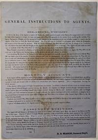
1855466Chicago: ICRR 1855. Broadside sheet. 280 x 195 mm. 11 x 8 /12 inches. Printed on blue paper folded brown stain in center portion of the sheet otherwise quite a good sound copy. Rare ICRR broadside containing instructions to their agents regarding freight accounts and passenger business with emphasis on recording and submitting Monthly Reports on all activities at their stations. It is signed by R. B. Mason General Sup't and though undated is from the early 1850's. Col. Roswell B. Mason was associated with the Illinois Central Rail Road from its inception overseeing construction of the line from 1852 to 1856 until he resigned in 1869 to become Mayor of Chicago. He was mayor during the fire of 1871 and used his power to declare martial law in its immediate aftermath. It is known that Abraham Lincoln served as counsel for Illinois Central in the early 1850s earning a fee of $5000 that occasion a law suit for nonpayment. Rare: this broadside in not among the Illinois Central Rail Road publications of the 1850s listed in OCLC. Not in Checklist of Ante-Fire Imprints 1851-1871. Not in Byrd Cecil B. Bibliography of Illinois Imprints 1814-1858 although three similar broadsides issued by Roswell Mason as General Superintendent are cited published in 1852 2 and 1855 1 all of which are in single copies at the Chicago Historical Society. (ICRR unknown
1855466Chicago: ICRR 1855. Broadside sheet. 280 x 195 mm. 11 x 8 /12 inches. Printed on blue paper folded brown stain in center portion of the sheet otherwise quite a good sound copy. Rare ICRR broadside containing instructions to their agents regarding freight accounts and passenger business with emphasis on recording and submitting Monthly Reports on all activities at their stations. It is signed by R. B. Mason General Sup't and though undated is from the early 1850's. Col. Roswell B. Mason was associated with the Illinois Central Rail Road from its inception overseeing construction of the line from 1852 to 1856 until he resigned in 1869 to become Mayor of Chicago.  He was mayor during the fire of 1871 and used his power to declare martial law in its immediate aftermath. It is known that Abraham Lincoln served as counsel for Illinois Central in the early 1850s earning a fee of $5000 that occasion a law suit for nonpayment. Rare: this broadside in not among the Illinois Central Rail Road publications of the 1850s listed in OCLC. Not in Checklist of Ante-Fire Imprints 1851-1871. Not in Byrd Cecil B. Bibliography of Illinois Imprints 1814-1858 although three similar broadsides issued by Roswell Mason as General Superintendent are cited published in 1852 2 and 1855 1 all of which are in single copies at the Chicago Historical Society. (ICRR unknown books
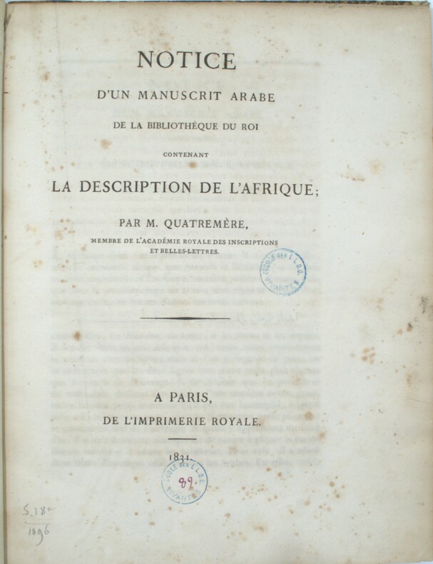
1831PHO-1372Paris , Imprimerie Royale , 1831 , in-4 , 230pp. , relié demi veau époque , tranches cailloutées ,ex-libris T.E. Mionnet (numismate ) , cachet ,dos manquant , frottements aux plats , rousseurs éparses.
1978013369Genève Claude Givaudan 1978 In-8 Cartonnage de L'éditeur Edition originale
XLIV, 477 pp., 7 pl. depl. (4 tableaux dépl. et 5 planches gravées) demi-veau havane, dos lisse orné (rel. de l'époque) 1827, 1827, in-8, XLIV, 477 pp, 7 pl. depl. (4 tableaux dépl. et 5 planches gravées), demi-veau havane, dos lisse orné (rel. de l'époque), Première édition de cet ouvrage « utile aux propriétaires de campagne, aux maires des communes rurales, aux membres des Conseils Généraux et d'arrondissements, aux préfets et sous-préfets, aux entrepreneurs de roulage et de messagerie, aux carrossiers, charrons et autres artistes » et consacré aux routes et à leurs défauts, aux moyens de les conserver et de les paver, à la théorie des roues, aux largeurs des jantes et à la nécessité de délimiter les changements, ainsi qu'aux voitures publiques. Une notice sur le procédé d'asphaltage des routes, selon le système de MacAdam complète l'ouvrage. Richard Lovell Edgeworth (1744-1817), écrivain et inventeur britannique, se proposait dans cet ouvrage de perfectionner les voies publiques en France et de développer le système de transports. Accidents à la reliure. Belles planches en fin d'ouvrage
24570Cambridge/ London, Deighton/ John W. Parker, 1853 Bound, cloth, gold impression on back, fold out landmap as frontispice, original title page, 140 x 230mm., 188pp., fold out landmap at the end of the book, 4 landscape engravings ( 1 fold out too ).
193232287Editions du Comité de l'Afrique Française, 1932. In-8 relié de pleine toile rouge brique (21 x 13,7 cm), couverture imprimée conservée, 324 pages, orné de 18 photographies dont 16 de Georges bruel, et 3 cartes. En guise de préface : Alfred Fourneau, l'un des "premiers cent" du Congo par Auguste Terrier.- Annotations de Georges Bruel.- 450g.- Pas de rousseurs, reliure en très bon état. EDITION ORIGINALE.
Cover Painting by William Winter shows a joyous last day of school. Features: Colour photo Studebaker Commander V-8 ad inside front cover; Nice colour ad for George Weston Limited shows bride-to-be with family; Spyglass on Sweden - the Welfare State; If the Russians Attack Canada - article with photos and interesting map of likeliest Canadian targets; Wide Open, Excellency, by Lesley Holmes; How the Stock Crooks Operate, by Fred Bodsworth - how the 'blower boys' peddle worthless stocks via long-distance phone; The Long Ordeal of Mrs. Tak Sook Kyun - the Korean War has taken her home near the Manchrian border, her husband, her baby, and tossed her up like driftwood on the crowded Pusan hills - article by Pierre Berton with sad photos; Banff - a paradise for Sultans and Stenos - article with great colour photos; The Ups and Downs of Alan Young - originally from West Vancouver, he fought his way to the top in radio and movies; What it's Like to Live in the Dark - Larry Bartlett was blinded by a German shell; Boswell of the Brooks - Writer Roderick Haig-Brown milks a cow every day and gets called "Your Worship" - article with photos; The Secret Behind The Fiery Phantom that Sails Bay Chaleur; Nice colour illustrated ad for Allis-Chalmers Rumely, Ltd showing a grader levelling a country road; Attractive colour ad for the Hillman Minx Convertible; Colour illustrated Coke centerfold shows store display and picnic lunch packed and ready to eat; Colour Chevrolet ad featuring a 2-door Bel Air; Nice colour photo ad for Snyder's Fine Furniture; Colour illustrated ad for the Ford Custom Deluxe Convertible; Nice 2-colour ad for the Austin A-40 Devon auto; Nice colour Parker Pen ad inside back cover features endorsement by Mazo De La Roche; Colour Margene ad on back cover. Average wear. Unmarked. Address label atop front cover. A sound copy of this particularly wonderful issue. Magazine