CÉARD Robert:Livre Rare Book

190 résultats
18572234Genève, Impr. de Gme Fick, 1857. In-folio broché de IX-69 pages, 29 planches. Coupes légèrement déchirées sur les plats, deux petits manques au bas et haut du dos, quelques rousseurs.
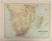
1877177228Edinburgh & London.: W. & A. K. Johnston. circa1877. Printed colour map 25 x 32.5 cm edge tears one affecting the lower border only two small chips from the upper margin corner repaired the map in very good condition. Map of North America with a small inset of the British Isles on the verso. Map of Southern Africa before the Scramble for Africa in the late 19th Century. . W. & A. K. Johnston. unknown
185830160Lyon Scheuring ( Imprimerie Louis Perrin ) 1858 In-8 108 pp
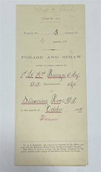
1875243423Standing Rock 1875. unbound. Partly printed military document signed 6th Infantry seven months before Little Big Horn 16.75 x 10.75 inches Standing Rock Nov. 1 1875 "A Statement Of Forage and Straw Issued to and Consumed by the Public Animals under my direction at Standing Rock Dakota Territory during the month of October 1875" for transient animals from Fort Rice signed by Captain and Commander of Post James S. Poland an officer who served under Major Reno at the Little Big Horn and was erroneously reported as "Killed In Action" when severely wounded in the back. At the time this document was signed Poland was ordered to cease his sale of rifles and ammunition to Indians at the Standing Rock Reservation as the recipients were closely connected with Sitting Bull's band. One month later the Commissioner of Indian Affairs called for the use of troops against those Indians. Also signed by Lieutenant William Badger a close friend of Custer who survived the Black Hills Campaign. His son Tom who filled out the body of this document became General Custer's personal secretary in 1876 and was killed at Little Big Horn. Also included: a Xerox of a rare photograph of the 7th cavalry 6th infantry in uniform with accoutrements all identified including Custer Badger and Poland. Partial tearing along one of the folds; otherwise near fine condition.<br/><br/> unknown books
1875320963Standing Rock 1875. unbound. Partly printed military document signed 6th Infantry seven months before Little Big Horn 16.75 x 10.75 inches Standing Rock Nov. 1 1875 "A Statement Of Forage and Straw Issued to and Consumed by the Public Animals under my direction at Standing Rock Dakota Territory during the month of October 1875" for transient animals from Fort Rice signed by Captain and Commander of Post James S. Poland an officer who served under Major Reno at the Little Big Horn and was erroneously reported as "Killed In Action" when severely wounded in the back. At the time this document was signed Poland was ordered to cease his sale of rifles and ammunition to Indians at the Standing Rock Reservation as the recipients were closely connected with Sitting Bull's band. One month later the Commissioner of Indian Affairs called for the use of troops against those Indians. Also signed by Lieutenant William Badger a close friend of Custer who survived the Black Hills Campaign. His son Tom who filled out the body of this document became General Custer's personal secretary in 1876 and was killed at Little Big Horn. Also included: a Xerox of a rare photograph of the 7th cavalry 6th infantry in uniform with accoutrements all identified including Custer Badger and Poland. Partial tearing along one of the folds; otherwise near fine condition.<br/> <br/> unknown
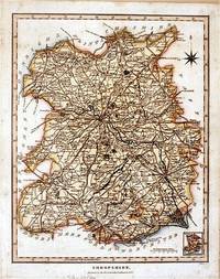
182761872London.: J. Wilkes. 1827. Attractive hand coloured map of Shropshire 27.5 x 21.5 cm. very occasional light foxing on reverse but not visible on the image itself. A most attractive map. . [J. Wilkes.] unknown
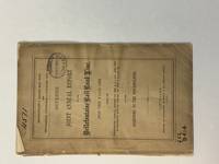
186340799Cleveland: Fairbanks Benedict & Co. 1863. Stitched in original printed wrappers. 33 1 blank pp folding table. Wrappers with extremity chipping and old rubberstamp. Rear wrap detached but present. Title page with rubberstamp. Old bookplate. Good plus.<br /> <br /> This is a joint report of the Bellefontaine & Indiana Rail Road and the Indianapolis Pittsburgh & Cleveland Rail Road. <br /> Wikipedia says: "The Indianapolis and Bellefontaine Railroad I&B was an American railroad founded in 1848. It changed its name to the Indianapolis Pittsburgh and Cleveland Railroad IP&C in 1854. Its counterpart in Ohio was named the Bellefontaine and Indiana Railroad B&I. The B&I ceased to exist as an independent company when it merged into the Bellefontaine Railway in September 1864. The Bellefontaine Railway merged with the Cleveland Columbus and Cincinnati Railroad to form the Cleveland Columbus Cincinnati and Indianapolis Railway in December 1864."<br /> OCLC 12696870 11 as of March 2025. Fairbanks, Benedict & Co. unknown
187912414Lyon, Imprimerie typographique H. Albert, 1879 ; petit in-8 carré, broché ; 242, (6) pp., couverture gris-bleu imprimée.
1884ca771Imprimerie Nationale Cartonné 1884 In-4, (33x26.5 cm), cartonné, atlas, 10 cartes en couleurs sur planches dépliantes, notice explicative en début d'ouvrage ; tampon sur la page de titre, traces dans le texte et sur les plats frottés, état correct. Livraison a domicile (La Poste) ou en Mondial Relay sur simple demande.
18272422619th Cong. 2nd Sess. HD105 Washington: Gales & Seaton 1827. 1827. 39 1 blank pp plus folding charts. Stitched as issued untrimmed and uncut. Very Good plus.<br/>OCLC 191257879 1-AAS. unknown books
187529071London ca. 1875. 3 S. erl. Text. Mehrfarb., grenzkolorierte Faltkarte auf Leinen gezogen 53 x 78 cm. Maßstab: 1 inch : 2 Miles. Landkarte. OLeinenbd. m. Goldpräg. Faltmaß 15x11 cm. [2 Warenabbildungen]
1820705531820. unknown
183016204Washington: Other. Very Good. 1830. Hardcover. Disbound; 17; 17 pages light foxing; backstrip splitting; charts and tables and reports regarding construction of the Cumberland Road; Good . Other hardcover books
184010777New York: Bryant and Boggs. 1840. Original printed wrappers with wrapper title as issued. pp 157-217 as issued. Several rubberstamps spine reinforced. Disbound. Good. With the first annual report of the directors of the Housatonic Rail Road Company its engineer's report and the report of the engineer of the Berkshire Rail Road Company. The Joint Special Committee's Report examines the feasibility of links between the Housatonic Road-- via Bridgeport CT and Stockbridge MA-- and New York City and its system of railroads. FIRST EDITION. Thomson 2535 7. AI 40-4958 no locs. or collation. Not in Sabin. Bryant and Boggs. unknown books
184010777New York: Bryant and Boggs. 1840. Original printed wrappers with wrapper title as issued. pp 157-217 as issued. Several rubberstamps spine reinforced. Disbound. Good. With the first annual report of the directors of the Housatonic Rail Road Company its engineer's report and the report of the engineer of the Berkshire Rail Road Company. The Joint Special Committee's Report examines the feasibility of links between the Housatonic Road-- via Bridgeport CT and Stockbridge MA-- and New York City and its system of railroads. FIRST EDITION. Thomson 2535 7. AI 40-4958 no locs. or collation. Not in Sabin. Bryant and Boggs. unknown
186496045Mine Hill and Schuylkill Haven Rail Road Company 1864. Pamphlet. Used - Very Good. 13-31 pages each. Large folding map. 9 x 6" printed wrappers. Lacking 1 lower wrap 1 creased few edge chips soiling tear else VG. Mine Hill and Schuylkill Haven Rail Road Company unknown
1844GD012817okBC1S5Manchester: Wetmore & Wallace 1844. Manchester: Wetmore & Wallace Rare Americana 1844 First Printing. 8vo. 16 pages with folding map at rear of wrappers. The folding map titled :Plan and Profile of the Route Surveyed for the Northern Railroad from Concord to Lebanon N.H." measuring approxinately 28" long and 9" wide. The map is in extremely nice condition. The spine shows some wear but remains a very nice copy. A signature of S.Chase" appears on the front wrapper. There is an institional rubber stamp on the margin of page 3. Vermont Historical Society Montpelier Vermont. This report printed by Wetmore & Wallace Printers in Manchester New Hampshire presents the findings of an engineer's survey for the Northern Railroad route. It covers the planned railroad connections between Concord Franklin and complete with Lebanon along the Connecticut River. Published in 1844 this document provides historical insight into the development of New Hampshire early railroad infrastructure and the engineering challenges faced in the region at that time. Scarce copy last auction records 1930. First Printing. Paperback. Good/No Jacket. 8vo - over 7¾" - 9¾" tall. Manchester: Wetmore & Wallace
188210744Paris, s.n., novembre 1882 ; in-folio, broché ; 59 pp., couverture grise imprimée, 75 plans côtés, texte manuscrit lithographié.
1823ST20595London: Longman Hurst Rees Orme and Brown 1823. Seventh Edition. 237 x 145. 9 3/8 x 5 3/4". 3 p.l. vii 1 viii 1 6-236 pp. <br/> Publisher's blue paper boards and brown paper backstrip original printed paper label EDGES UNTRIMMED AND MOSTLY UNOPENED. A Large Paper Copy. Just the faintest evidence of foxing at very beginning and very end corners with slight wear as always superficial chafing to covers but AN EXCEPTIONALLY FINE COPY the binding remarkably clean and with no significant signs of use and the wide-margined text unusually fresh and nearly as white as snow.<br/> <br/> In its original boards untrimmed and partly unopened this is a wonderful contemporary copy of an important later edition of the magnum opus of a man whose name came to be synonymous with road improvement. DNB tells us that Scottish-born John Loudon McAdam 1756-1836 was "the first systematic builder and administrator of roads in Britain since Roman times" and his impact was so great that his name lives on to the present day in connection with paved surfaces. The use of "macadam" or "macadamized" to mean a good road surface began in the 1820s and continued through the invention of the automobile when dusty roads began to be improved with tar. At first "tar" was combined with "macadam" producing the term "tarmacadam" when referring to these improved roads; eventually this became shortened to "tarmac" which still is broadly understood to refer to road surfaces and more specifically to airport runways. Our author first published "Remarks on the Present System of Road Making" in 1816 to deliver his suggestions for an improved paving method following his extensive survey of the roads of Britain. His system--in which roads were built with a cambered surface for drainage using layers of consistent sizes of stones and gravel--soon caught on both within Britain and abroad. The present seventh edition features a variety of new material much of which deals with McAdam's efforts to encourage legislation for improving roads; this includes a new preface and advertisement as well as the "Minutes of Evidence" given by witnesses regarding turnpike improvement from March to May 1819 and the report of the Select Committee of the House of Commons on McAdam's system from June 1823. As evidenced by its appearance in multiple printings McAdam's "Remarks" was a widely used book but our remarkably well-preserved copy in its publisher's boards--obviously and decidedly--was not. Longman, Hurst, Rees, Orme, and Brown unknown
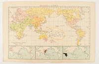
1895175135London.: Times Atlas of the World. 1895. Map printed in colour 23.2 x 35.9 cm. two edges gilt with three inset maps key to religions outlined in colour bottom margin chipped edges browned a few silverfish abrasions affecting the verso but in good condition. . (Times Atlas of the World) unknown
1824PHO-2191Paris, Everat, 1824, in-4 (260x210mm), 2ff-LIV-568pp-1ff , avec en fin d’ouvrage la liste des membres de la Société de Géographie, relié demi toile, dos lisse avec étiquette de titre, éditeur et tomaison, frottements aux plats et étiquette usée, vieille mouillure claire en coin, piqures.
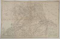
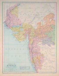
1859189711Calcutta.: Surveyor Generals Office. 1870. Reissue of 1859 edition. Lithographed map 57.2 x 93 cms; 61.1 x 96 cms sheet original folds old paper repairs to the verso and a sealed marginal tear central folds archivally strengthened some toning to the folds and creasing but the map in remarkably good clean condition. Impressive large Calcutta printing from the Survey of India showing Rajasthan Uttar Pradesh and surrounding states with extremely detailed delineation of settlements roads railways rivers and major points of interest the Taj Mahal is highlighted. . Surveyor Generals Office. unknown
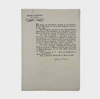
1835377678Mexico 1835. 1. plus integral blank. Signed in print by Estrada. Folio. Unbound. 1. plus integral blank. Signed in print by Estrada. Folio. A broadside decree issued by Migual Barragan giving city status to Pueblo de Nuestra Se ora la Reina de Los Angeles and naming it the provisional capital rather than Monterey. The Mexican congress declares: "The town of Los Angeles of Alta California is elevated to the rank of city and it will be from now on the capital of this territory." However representatives from Monterey would block moving the capital. <br /> <br /> "This decree was largely due to the efforts of Carlos Antonio Carrillo the deputy from California to the Mexican Congress and the author of the Exposicion of 1831" Streeter. Streeter's copy sold for $200 to Dawson's in 1968. Eberstadt 133-187; Streeter sale 2476; Rocq 4223 unknown
1880187528Edinburgh.: J. Bartholomew. circa1880s. Map 40.2 x 30.4 cms with printed colour and outline hand colour in very good condition. Handsome map with colonial interests attractively coloured. . J. Bartholomew unknown
181716310Paris, Imprimerie impériale, 1817 ; in-8, vélin à rabat portefeuille (reliure ancienne, parchemin réutilisé) ; 362 pp.