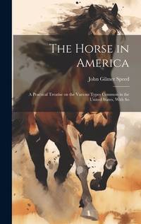
John Gilmer SpeedBiblio.com
1 204 résultats
B9781163788035New. unknown
1019614331.Ghardcover. Good. Access codes and supplements are not guaranteed with used items. May be an ex-library book. hardcover
0548477876.Gpaperback. Good. Access codes and supplements are not guaranteed with used items. May be an ex-library book. paperback
1163788031.Gpaperback. Good. Access codes and supplements are not guaranteed with used items. May be an ex-library book. paperback
Features: Princess Margaret and her own regiment - in Glasgow and Ayr; Water Speed Record; British Arms for Iraq; Polo in Japan; Amazing 2-page photo of a large pile of Thunderjet aircraft shells in the Arizona desert; Framlingham College; Two newly-found masterworks of 2500 years ago - Ibexes in stone; and more. Moderate wear. Unmarked. Sound copy. Book
2007Q-1599792206Creation House 2007-07-13. Paperback. New. In shrink wrap. Looks like an interesting title! Creation House paperback
19911369216CAN. New. 1991. Soft Cover. This is a reprint edition. . CAN paperback
2001Q-0122374711Academic Press 2001-02-05. Paperback. New. New. In shrink wrap. Looks like an interesting title! Academic Press paperback
0122374711.Gpaperback. Good. Access codes and supplements are not guaranteed with used items. May be an ex-library book. paperback
1987Q-1566990203Rowman & Littlefield Publishers 1987-12-01. Paperback. New. In shrink wrap. Looks like an interesting title! Rowman & Littlefield Publishers paperback
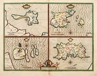
164663961London. c.1646. An excellent map by John Speed of the English Islands of: Farne and Holy Island off the Northumbrian coast; and the Channel Islands of Jersey and Guernsey. Each quatered map has a compass rose dividers and a mileage scale. Size: 430 x 550 mm. Copperplate engraving. Hand coloured. Good condition. Some minor staining to the centrefold and surrounding area. unknown
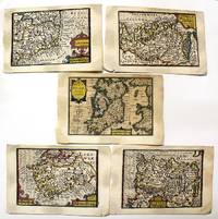
1632M11092London: Petrus Kaerius caelavit George Humble c.1632 . Very Good. Notes: A set of 5 miniature maps of Ireland and its counties.<br>Pieter van den Keere Latin: Petrus Kaerius 1571 – c. 1646 was a Flemish engraver publisher and globe maker who worked for the most part of his career in England and the Dutch Republic.<br><br>Miniature Speeds<br>A series of 44 plates for the British Isles from about 1599 took a long time to publish. They were based on Christopher Saxton Ortelius and Giovanni Battista Boazio respectively for England and Wales Scotland and Ireland. They appeared in 1617 in a Latin edition of the Britannia of William Camden by Willem Blaeu. Later these plates came to William Humble or George Humble according to Royal Geographical Society fellow Carl Moreland and David Bannister—map dealer—in "Antique Maps" who issued them with some modification and expansion in 1627 as a miniature version of the atlas of John Speed. Thereby van den Keere's works came by the name "Miniature Speeds".<br> Size : 85x123 mm 3.35x4.84 Inches Coloring: Original Hand Coloring Category: Maps Europe Ireland; Petrus Kaerius caelavit [George Humble] unknown
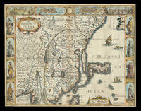
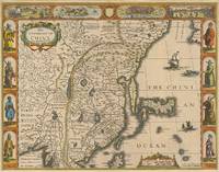
162621928<p>London: Are to be sold in pops-head Alley by G. Humble 1626 but 1627-1632. 405 by 515mm. 16 by 20.25 inches. Speed's map of China Double-page engraved map with hand-colour. A map of China also encompassing Korea and some of the islands of Japan from the first atlas compiled and published by an Englishman Speed's 'Prospect'. Along the top of the map is a decorative border with bird's-eye views of the islands of Macao after de Bry and Quinzay modern-day Hangzhou as well as dubiously accurate vignettes showing 'ye Manner of their Travelling by land' and 'the Manner of their Execution'. Along the sides of the map are depicted figures including one of the earliest European depictions of a Japanese soldier. Korea is shown as a long island and Japan is drawn after Ortelius and Teixeira. The Great Wall of China "built by ye King of China against ye breaking in of ye Tartars" separates China from the 'Desert Lop' which divides it from Russia. Here small diabolical figures are illustrated accompanied by the warning that "men are thought to be seduced by wonderfull illusions and divilish spitting". Accompanying text in English 'The Description of the Kingdome of China' is printed on the reverse. John Speed 1552-1629 was the outstanding cartographer of his age. By trade a merchant tailor but by proclivity a historian it was the patronage of Sir Fulke Greville poet and statesman that allowed him to pursue this interest in earnest. His 'Theatre of Great Britain' first published in 1611 or 1612 was the first large-scale printed atlas of the British Isles. The 'Prospect of the Most Famous Parts of the World' from which the present work is drawn appeared in 1627 bound with the 'Theatre' and is the first world atlas compiled by an Englishman to be published in England. Engraved in Amsterdam many of the maps are anglicized versions of works by Dutch makers in distinctive carte-à-figure style featuring borders with figures in local costume and city views. Chubb XXV; Shirley Atlases T.SPE-2a.</p> Are to be sold in pops-head Alley by G. Humble,
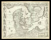
167621924<p>London: are to be sold by Tho: Bassett in Fleet Street and Ric: Chiswell in St. Pauls Churchyard 1676. 400 by 520mm. 15.75 by 20.5 inches. Speed's map of Denmark Double-page engraved map. A map of 'the Kingdome of Denmarke' comprising modern-day Denmark and parts of Sweden and Germany from the 1676 edition of the first atlas compiled and published by an Englishman Speed's 'Prospect'. The upper border contains views of major cities including Copenhagen and Hamburg with the arms of Christian King of Denmark at the centre and portrait medallions of Christian IV and of his son and heir Frederick on either side. Along each side are illustrated figures wearing regional costumes. Accompanying text in English 'The Description of the Kingdom of Denmark' is printed on the reverse. John Speed 1552-1629 was the outstanding cartographer of his age. By trade a merchant tailor but by proclivity a historian it was the patronage of Sir Fulke Greville poet and statesman that allowed him to pursue this interest in earnest. His 'Theatre of Great Britain' first published in 1611 or 1612 was the first large-scale printed atlas of the British Isles. The 'Prospect of the Most Famous Parts of the World' from which the present work is drawn appeared in 1627 bound with the 'Theatre' and is the first world atlas compiled by an Englishman to be published in England. Engraved in Amsterdam many of the maps are anglicized versions of works by Dutch makers in distinctive carte-à-figure style featuring borders with figures in local costume and city views. This map is from the 1676 edition of the 'Prospect' published by Thomas Bassett and Richard Chiswell. While not as rare as the earlier publications this edition is perhaps the most important given that it is the first to include the nine new maps: among them Virginia and Maryland Barbados and Russia. It is also the last time that the 'Prospect' was printed as an atlas. Shirley Atlases T.SPE-2f.</p> are to be sold by Tho: Bassett in Fleet Street and Ric: Chiswell in St. Pauls Churchyard,
64286London: Are to be sold in pops-head Ally by G. humble 1627-32. Original copper engraved map sheet 40.5 x 52 cm; plate: 39.5 x 51 cm with later hand-colouring of China also showing Korea and Japan. Vignette views of Macao and Quinzay and scenes showing the Chinese manner of 'Travelling by Land' and 'Execution' in the upper border. Eight illustrations showing different types of oriental costume four in the left border and four in the right. English text 'Description of the Kingdome of China' to verso. Watermark to western side. Excellent condition. [London: Are to be sold in pops-head Ally by G. humble 1627-32]. unknown
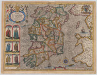
161038006London: John Sudbury and George Humble 1610-27. In very good to excellent condition. 38.5 x 51 cm 15.25 x 20 inches. Original antique copper engraving hand colored in outline and wash very likely old colored. Engraved by Jodocus Hondius. Published 1627 English text edition. Very decorative map of the County of the kingdom of Ireland. At the top left is the title cartouche on which two putti are sitting holding a harp. Below are six engraved costume prints depicting three couples: Gentleman / Gentlewoman of Ireland Civil Irish woman / Civil Irish Man Wild Irish man / Wild Irish woman. In the top right corner we the coat of arms with the inscription 'God and my right' in French language. In the Irish Sea next to the compass rose and mileage scale a sailing ship and a sea monsters are engraved. Below the imprint with the publisher John Sudbury and George Humble and the privileg dated 1610. An early edition of this rare map of Ireland with strong engraved waves in the sea. John Speed 1551 oder 1552 – 28. Juli 1629 war ein englischer Kartograf Chronologe und Historiker mit Wurzeln in Cheshire. Als Sohn eines Bürgers und Schneiders in London verließ er den Beruf seiner Familie um die Aufgabe anzunehmen die Geschichte Topografie und Karten der Königreiche Großbritanniens zusammenzustellen und zu überarbeiten um die Vereinigung ihrer Monarchien in der Person von König James I. und VI. darzustellen. Er erreichte dies mit bemerkenswertem Erfolg mit der Unterstützung und Hilfe der führenden Altertumsforscher seiner Generation. Er stützte sich auf die Shire-Karten von Christopher Saxton John Norden und anderen und verbesserte sie indem er als Erster die Hundertgrenzen in sie einfügte und er war der Landvermesser und Urheber vieler der darin enthaltenen Stadtpläne. Seine Arbeit trug dazu bei frühneuzeitliche Konzepte der britischen Nationalidentität zu definieren. Seine biblischen Genealogien wurden auch offiziell mit der Erstausgabe der King-James-Bibel in Verbindung gebracht. Er gehört zu den berühmtesten englischen Kartografen. Wikipedia.A minor marginal light staining in very good to excellent condition. 2nd English edition 1616 P. 255 John Sudbury and George Humble unknown
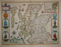
16767572London: Basset & Chiswell 1676. Copper engraving 38.5 x 51.5 cms recent hand-colour light crease in the lower right hand corner but generally a very good example; English text on verso. Cartographically Speed follows Mercator but his is one of the most distinctive and decorative early maps of Scotland. The portraits in the borders originally represented James VI and I and his family including a young Prince Charles. The royal family was burnished from the copper plate during the Interregnum and replaced with the commoners seen here: a Scotch man and woman and a Highland man and woman notable as early depictions of tartan. John Speed 1552-1629 is unquestionably the most significant British map-maker of the seventeenth-century. A brief note from Granger's Bibliographical History of England 1779 contains most of the information we have about Speed's life: "John Speed who was bred a Tailor was by the generosity of Sir Fulk Grevil his patron set free from a manual employment and enabled to pursue his studies to which he was strongly inclined by the bent of his genius. The fruits of them were his Theatre of Great Britain containing an entire set of maps of the counties drawn by himself his History of Great Britain richly adorned with seals coins & medals from the Cotton collection; and his Genealogies of Scripture first bound up with the Bible in 1611 which was the first edition of the present English translation. His maps were very justly esteemed & his History of Great Britain was in its kind incomparably more complete than all the histories of his predecessors put together ." The first edition of Speed's "Theatre" was published in 1612. It was the first atlas of the British Isles and the first attempt made by an Englishman to match the achievements of the great continental publishing houses - although much of the engraving of the copper plates was performed in Amsterdam by Jodocus Hondius. Speed was an antiquary and intended that his atlas should be read in conjunction with his history of Britain. He managed to include a great deal of historical detail on his 'modern' county maps and the inset town plans some surveyed by himself together comprise the first collection of town plans of the British Isles all in all making the Theatre a highly decorative as well as a useful volume. It was a great success and there were editions printed throughout the seventeenth-century. Map Basset & Chiswell unknown
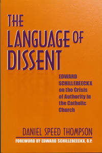
2003x-0268033587Univ of Notre Dame Pr 2003. Hardcover. New. 288 pages. 9.00x6.25x0.75 inches. Univ of Notre Dame Pr hardcover
63847612University of Notre Dame Press pp. 256 . Hardback. New. University of Notre Dame Press hardcover
63847444University of Notre Dame Press pp. 256 . Papeback. New. University of Notre Dame Press unknown
188328255New-York: Dodd Mead & Company 1883. Very Good. New-York: Dodd Mead & Company 1883. First Thus Limited to 279 sets printed on Holland paper of which this is no. 160. Three volumes; octavos; publisher's buff paper-covered boards black spine titling; frontispieces at head of each volume that of Vol. I printed in color. Ex-Darrow Gibbs School Library with their early 20th-century ex libris to front free endpapers and usual internal markings to Vols. II & III faint evidence of previously-removed spine labels boards a bit scuffed and spines toned Vol. III upper cover unevenly discolored and faintly damp-stained with brief ink numeral to front free endpaper else a Very Good still quite attractive set. Dodd, Mead & Company unknown
0898152135.Ghardcover. Good. Access codes and supplements are not guaranteed with used items. May be an ex-library book. hardcover
2007363547Cobourg: Collector Grade Publications 2007. First edition. hardcover. very good/very good. 4to. pp.546. heavy book additional postage will apply0889354375 Collector Grade Publications hardcover
20081-141695080XAladdin Paperbacks 2008. Paperback. New. 176 pages. 9.00x7.50x0.50 inches. Aladdin Paperbacks paperback
2008Q-141695080XAladdin 2008-05-20. Paperback. New. New. In shrink wrap. Looks like an interesting title! Aladdin paperback