Fer, Nicolas deBiblio.com
199 résultats
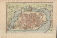
1715019811Paris. Very Good. 1715. Map. Lovely engraved map depicting Mexico City in the early 18th century. Map is on a 10 ¾" x 15 ¾" sheet that was taken from Nicolas de Fer's "L'Atlas Curieux" of 1715; no content on verso. Date of map was printed in upper margin along with the sheet number "125" and title; content in French. Hand-coloring is still bright. Map has very light toning to edges but is otherwise clean. This detailed map depicts Mexico City when it was surrounded by water and was linked to the mainland by the famous causeways originally designed by the Aztecs. Also pictured are aqueducts and farms and about 50 locations have been numbered on the map but the key is not present likely printed on another page in the Atlas. A beautiful map. . unknown
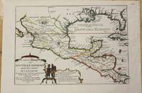
1705M772Paris 1705. Excellent. Notes: This map covers the Gulf of Mexico through Central America and includes parts of Cuba and Jamaica. It extends through Mexico to show the southern tip of Baja California. This is an early map to show the correct location of the Mississippi River delta gleaned from the expeditions of La Salle and Iberville. Two French forts are located: LaSalle's Fort St. Louis in Texas Fortbati en 1685 and another near present-day New Orleans. One of the prominent features in northern Mexico is Les Fameuses Mines de Ste. Barbe the legendary Santa Barbara mines of the Chihuahua-Durango region. Size : 230x335 mm 9x13.125 Inches Coloring: Original Outline Coloring Category: Maps Central America Mexico unknown
1705M5280Paris 1705. Excellent. Size : 225x340 mm 8.875x13.375 Inches Coloring: Hand Colored Category: ; Maps Europe Estonia Latvia unknown
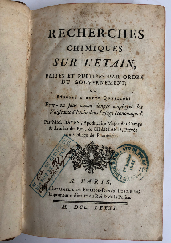
1781ARC-113870Préface, dans laquelle le traducteur indique les problèmes rencontrés par la conversion des mesures suédoises en mesures françaises alors fort nombreuses (pp. I-XVI). Dissertation chimique de l'analyse du fer. Précédée d'un en tête gravé sur bois par Jean Beugnat, qui représente un laboratoire de chimie avec un fourneau et une cornue ; importantes notes de l'auteur et du traducteur (pp. 1-124). Appendice contenant des Observations particulières du Traducteur (pp. 125-186). Mémoire sur les moyens de perfectionner le travail des ancres de marine, par M. Grignon (pp. 187-197). Mémoire qui présente plusieurs moyens de perfectionner les opérations de métallurgie, par M. Grignon (pp. 198-219). Observations sur l'action réciproque que le feu et l'eau ont l'un sur l'autre, par M. Grignon (pp. 220-232). Mémoire contenant les détails, analyses et résultats des expériences faites en 1780 dans les forges du comté de Buffon en Bourgogne et dans la manufacture Royale d'Acier fin de Néronville en Gâtinois, par M. Grignon (pp. 234-284). Paris, Philippe-Denys Pierre, Méquignon, 1781 / 1783, 2 ouvrages en 1 volume, in-8, relié, VIII-285 pages. 1 feuillet non chiffré XVI-286 pages..
1766LBW-8594Paris, Desnos, 1766. 398 x 547 mm.
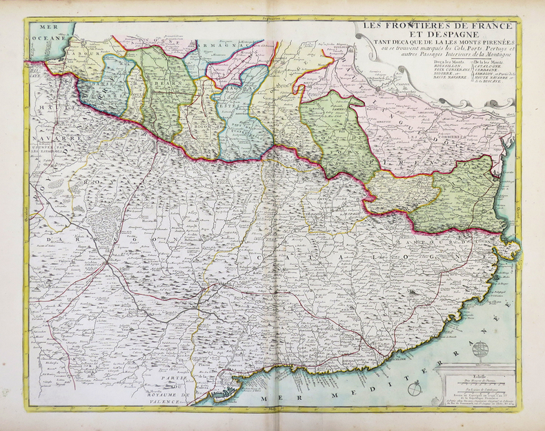
1720LBW-3720[Paris, circa 1720]. 451 x 554 mm.
171750277Paris: Guillaume Danet Son-in law of the author 1717. Second edition. Hardcover. Good- to very good condition. Octavo. 197 9pp. 5 folding maps. Original calf with gilt lettering tooling and ruling on spine; raised bands. Decorative endpapers. Title page with copperplate engravings of two hand-colored printed globes and black double-framing California depicted as an island in this and two other maps. Second edition augmented with longitudes and latitudes of major cities. Illustrated headpiece decorative initials and endpieces. All pages with double frames; marginalia. <br /> <br /> Introduction to geography by the French cartographer and engraver Nicolas de Fer 1646–1720 containing five folding copperplate engraved maps four of them hand-colored. The first showing a general map of the globe with America in one Europe Africa and Australia in the second globe both with North and South Poles. The margins are adorned with hand-colored portraits of significant explorers; Columbus Vespuci Shouten etc. The second map is the only one in black and white. It depicts "La Sphere Artificielle." The third map shows Europe the fourth Asia the Middle-East and Oceania with parts of Europe and Africa and finally North and South America depicted on the fifth. Contains list of cities and catalog of Fer publications at rear.<br /> <br /> At the age of twelve Fer became an apprentice of the Parisian engraver Louis Spirinx. After the death of Fer's father in 1673 he also was a cartographer Nicolas took over the business specializing in the production atlases geography and cartography-oriented publications. Well connected to the Royal Court Fer advanced to become the official geographer of the Philip V of Spain and Louis XIV of France. His numerous publications are considered artistic rather than accurate.<br /> <br /> Text in French. Binding rubbed along edges and boards with front joint mostly cracked but holding together. Small plate of previous owner glued to upper inside front cover. Inked and penciled notes on verso of decorative front endpaper. Starting at title page. Some creasing and small closed tears of maps. B/w map with two inch tear reinforced with tape on verso. Map of Europe with four inch closed tear. Map of America also reinforced with three and a half inch paper strip on verso. Page ninety-three with remnants of black glossy paper glued to gutter and part of text some loss of text. Binding in overall good- interior in good to very good condition. Guillaume Danet (Son-in law of the author) hardcover
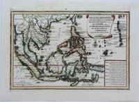
1702M5177Paris 1702. Excellent. Size : 235x340 mm 9.25x13.375 Inches Coloring: Original Outline Coloring Category: ; Maps Asia South East unknown
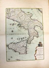
1708M10188Paris: chez Benard c.1708. Very Good. Notes: A detailed map of Southern Italy and Sicily also shows Malta. With wide margins and a pair of coats of arms is placed on top of the cartouche. Size : 560x402 mm 22.05x15.83 Inches Coloring: Original Hand Coloring Category: Maps Europe Italy; Maps Mediterranean Islands; chez Benard unknown
17026200Paris: Chez l'Auteur 1702. First printing. Map folio sheet 12.75"x9" 23x33cm. Copperplate engraving. Significant early map of this area locating the mouth of the Mississippi correctly as taken from the information reported by M. La Salle. The right edge includes all of Florida and most of Cuba; the left cuts off most of Baja California. Santa Fe New Mexico is shown at the top the bottom cuts off at the Isthmus of Panama. Attractive cartouche showing two Indians in full regalia. Hand-colored probably contemporaneously. Fine copy. <br/><br/> Chez l'Auteur unknown books
1720LBW-5641[Paris, circa 1720]. 458 x 557 mm.
1702LBW-1304Amsterdam Pierre Mortier 1702 210 x 270 mm.
172426462Carte gravée au format 60 x 46 cm, Chez le Sr Danet, Gendre de l'Auteur sur le Pont Notre Dame à la Sphère Royale, 1724, à l'échelle de 500 pas communs
170123030Paris: Nicolas De Fer 1701. First Edition. Very Good. Ginville Vincent de. Ginville Vincent de. First Edition. Paper size 42.5 cm x 28.5 cm. Plate mark 34 x 22.5 cm. Marginal paper clip stain inked '109' upper right corner some marginal chipping to the paper and old penciled price lower right. A few unobtrusive spots inside the plate marks. Copperplate engraving by Vincent de Ginville with later awfully bright hand color. This map would frame up nicely. There appears to be several versions of this map. The David Rumsey Collection has an example dated on the cartouch 1705 which he notes as being from Nicolas De Fer's Atlas Curieux published later. <br /> <br /> The Library of Congress has an example of the map offered here with the 1701 date and a separate page with explanations of the map. We don't know where this 1701 example came from separately issued or another atlas. The map highlights locations of Indian villages found by La Salle during his explorations of the coastal areas of the United States. We see the Gulf of Mexico Cap de la Floride and many inland village names. A nice map showing some early history of the southern United States. It includes parts of modern-day Louisiana Mississippi Alabama and Florida as well as the Bahamas and Cuba. Nicolas De Fer unknown
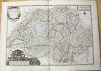
1764M10199Paris c. 1764. Very Good. Notes: An important and decorative map of Switzerland published in mid 18th century. The map originally was drawn by De Fer and later updated and improved by Desnos. Size : 485x670 mm 19.09x26.38 Inches Coloring: Hand Colored Category: Maps Europe Switzerland; unknown
172226591722 1722 J.F. Bernard, Paris, 1722.1 volume in-4 plein veau d'époque, dos à nerfs orné de fleurons en encadrement de filets, pièce de titre, [2ff.] blancs, [141ff.] non chiffrés et [1f.] blanc. Bien complet des 65 gravures en taille-douce (chiffrées de 4 à 69, la page de titre, l'épître et la table comptant pour les gravures 1 à 3). Chaque notice royale et accompagnée d'une gravure présentant un portrait et une figure allégorique. Ex-libris. Bel exemplaire malgré quelques épidermures.
176621550Paris, Pierre-François Didot, le Jeune, 1766 ; in-12, veau marbré, dos lisse à faux nerfs dorés, décoré et doré, pièce de titre grenat, tranches rouges (reliure de l’époque) ; [8], 392 pp.
1706M6655Paris c. 1706. Very Good;. Notes: Cartouche in upper right corner depicts the shield of the Royal coat of arms of the United Kingdom three hunting dogs and a cockfight. The cartouche in the upper left defines the geographical coordinates of London Edinburgh Dublin and Dunkirk. Size : 460x486 mm 18.11x19.13 Inches Coloring: Original Outline Coloring Category: Maps Europe United Kingdom; Maps Europe Ireland; unknown
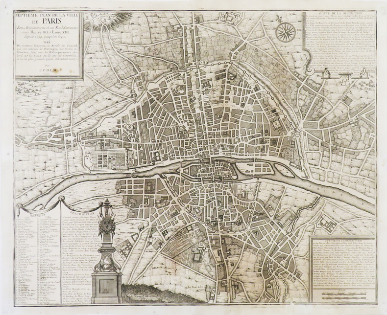
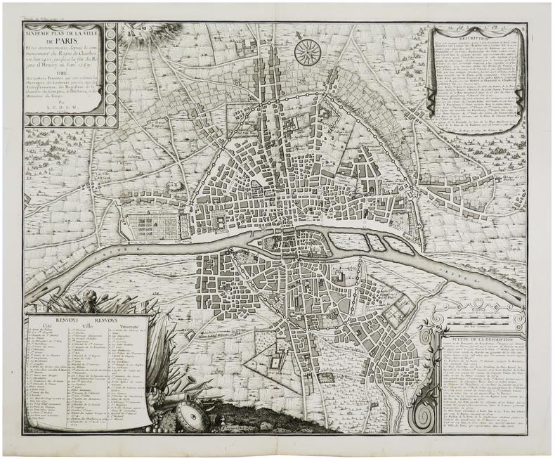
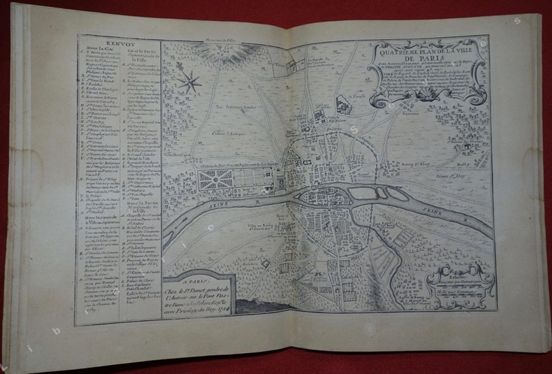
1724197811724 Sans page de titre, Paris,( chez le S.r Danet, 1724), in-4 composé de 17 feuillets comportant 9 plans de Paris et 8 notices gravées, de format 38,5 cm x 26 cm, pliés en 2 et montés sur onglets, l'ensemble placé dans une ancienne reliure de l'époque (plus courte), de plein velin ivoire avec titre de maroquin rouge dans la hauteur du dos, Le dernier plan qui n'est pas accompagné de notice comme les précédents est un " Plan de la conduite des eaües des fontaines publiques de la ville de Paris" daté de 1716, anciennes réparations à quelques pages, bon ex.
1792LBW-4312Paris, Desnos, 1792. 498 x 603 mm.
1705M4344Paris 1705. Excellent. Notes: This decorative map focuses on the French possessions in North America. The treatment of French Florida is intriguing. The map shows the United States of America and parts of Southern Canada East of the Mississippi river.<br>"Territorial expansion of New France had reached the Mississipi River with the establishment of the first European settlement at Fort Maurepas by Pierre Le Moyne d'Iberville in 1699 sixteen years after La Salle had reached the mouth of the river. This attractive map from 'L'Atlas Curieux ou le Monde' paris 1705 although containing geographical errors has many interesting historical notes" -The Macdonald Stewart Foundation Size : 232x342 mm 9.125x13.5 Inches Coloring: Hand Colored in Outline Reference: The Macdonald Stewart Foundation "La Decouverte du Monde Cartographes et Cosmographes" Map # 44; McCorkle 702.2 Category: ; Maps North America Great Lakes; Maps Canada; Maps Canada East; Maps United States East; Maps United States South unknown
1719291534Paris 1719. Map. Engraving with original hand outline color. Image measures 19 x 23". Sheet measures 20 x 28".<br/><br/> Unusual map of Peru from the early 18th century. Includes part of Ecuador Bolivia and Brazil based on Jesuit activity in the area. Amazon rain forest is visualized with a dynamic design. Cartouche describes the mining industry. Nicolas de Fer 1646-1720 was a prolific cartographer engraver and publisher who took over the family map business from his mother when she retired in 1687. The business flourished and he gained a great reputation in his lifetime and was appointed 'Geographer to the King' in 1690. This map demonstrates his skill and provides a curious yet alluring mixture of history and geography.<br/><br/> unknown books
1719291534Paris 1719. Map. Engraving with original hand outline color. Image measures 19 x 23". Sheet measures 20 x 28".<br/> <br/> Unusual map of Peru from the early 18th century. Includes part of Ecuador Bolivia and Brazil based on Jesuit activity in the area. Amazon rain forest is visualized with a dynamic design. Cartouche describes the mining industry. Nicolas de Fer 1646-1720 was a prolific cartographer engraver and publisher who took over the family map business from his mother when she retired in 1687. The business flourished and he gained a great reputation in his lifetime and was appointed 'Geographer to the King' in 1690. This map demonstrates his skill and provides a curious yet alluring mixture of history and geography.<br/> <br/> unknown
1760M5799Paris: Desnos 1760. Very Good. Notes: French map of Poland Lithuania and the surrounding region.<br>1760 edition of rare Nicolas De Fer's map. Size : 480x590 mm 18.875x23.25 Inches Coloring: Hand Colored in Outline Category: Maps Europe Poland Lithuania Desnos unknown
1704M10805Paris: St. Gaspar Baillieu 1704. Very Good backed on acid free tissue paper for long term preservation. Notes: Fine large scale map focused on Southern Portugal and Southern Spain. The map is surrounded by inset maps of Olivenca Castello Ferreire Aronches Badaioz Lisbonne Setubal Chateau St. Iulien Evora.<br> Size : 561x940 mm 22.09x37.01 Inches Coloring: Original Hand Coloring Category: Maps Europe Spain; Maps Europe Portugal; St. Gaspar Baillieu unknown