[Réaumur], [Duhamel du Monceau], [Courtivron (Marquis de)]Livre Rare Book
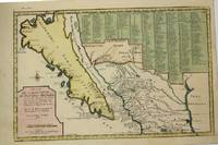
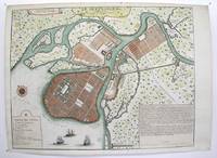
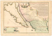
MAP Les Costes Aux Environs De La Riviere de Misisipi Decouvertes par Mr. de la Salle en 1683 et reconnues par Mr. le Chevallier d'Iberville en 1698 et 1699
170123030Paris: Nicolas De Fer 1701. First Edition. Very Good. Ginville Vincent de. Ginville Vincent de. First Edition. Paper size 42.5 cm x 28.5 cm. Plate mark 34 x 22.5 cm. Marked "sculpsit Vincent de Ginville" lower left. Paper clip mark just to the plate mark upper margin '109' inked upper right corner some marginal chipping to the paper marginal old pencil price lower right. A few unobtrusive spots inside the plate marks. Copperplate engraving with later hand color. From Nicolas De Fer's Atlas Curieux. Highlights locations of Indian villages found by La Salle during his explorations of the coastal areas of the United States. LOC online We see the Gulf of Mexico Cap de la Floride and many inland village names. A nice map showing some early history of the southern United States. Nicolas De Fer unknown books

Kuenzig Books, ABAA · États-Unis1 375,00 $US≈ 1 163,39 €