de Fer, NicolausBiblio.com
199 résultats
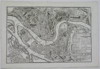
170219554Paris: N. de Fer 1702. Other. One old crease in the paper else in very good condition. 232 by 349mm 9 by 13 inches. 232 by 349mm 9 by 13 inches. Hand-Colored Original Copperplate Engraving by Nicolaus de Fer depicting Cologne. Published Paris N. de Fer 1702. Sheet: 232 by 349mm 9 by 13 inches. A fine and original hand-colored example of de Fer's celebrated cartographic work documenting this region of Germany with the precision and decorative artistry characteristic of the 17000s. Nicolaus de Fer was a cartographer active in the 1700s working in the tradition of European copper-engraved cartography. Their maps are valued by collectors for their historical accuracy and decorative quality.This original copperplate engraving with original hand coloring depicts the region of Cologne published in Paris N. de Fer 1702. The map records the political and geographic boundaries of the region as understood in 1702 offering a fascinating window into the history of German territorial organization. Sheet measures 232 by 349mm 9 by 13 inches. In excellent condition. Ready to frame. N. de Fer unknown
1706M6386Paris 1706. Very Good margins extended. Size : 130x175 mm 5.125x6.875 Inches Coloring: Hand Colored Category: ; Maps Europe Portugal unknown
1706M6388Paris 1706. Very Good margins extended. Size : 130x180 mm 5.125x7.125 Inches Coloring: Hand Colored Category: ; Maps Europe Portugal unknown
1706M6382Paris 1706. Very Good margins extended. Size : 125x175 mm 4.875x6.875 Inches Coloring: Hand Colored Category: ; Maps Europe Spain unknown
1706M6389Paris 1706. Very Good margins extended. Size : 130x180 mm 5.125x7.125 Inches Coloring: Hand Colored Category: ; Maps Europe Portugal unknown
1706M6387Paris 1706. Very Good margins extended. Size : 130x175 mm 5.125x6.875 Inches Coloring: Hand Colored Category: ; Maps Europe Portugal unknown
1705LBW-60851705. 225 x 322 mm + feuillet de texte descriptif.
1705LBW03934Paris, G. Danet, 1705 [circa 1720]. 429 x 420 mm.
1705LBW-2899Paris, chez l'auteur, 1705. 226 x 340 mm.
1705LBW-6117Paris, Sr. de Fer, 1705. 223 x 302 mm + feuillet de texte descriptif.
1705LBW-2900Paris, 1705. 233 x 337 mm + feuillet de texte.
1705LBW-708Paris, 1705. 221 x 332 mm.
170578854Paris: 1705. Map of the Bishopric of Liege and the surrounding areas of Maastricht. Published in "Atlas Curieux ou le Monde". Copper engraving. Hand coloured. Size: 273 x 402 mm Very good condition. unknown
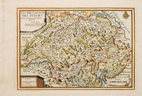
170578548Paris: 1705. Nicolas de Fer's excellent map of the German states. From the "Atlas Curieux ou Le Monde". Copper engraving. Hand colouring. Size: 274 x 405 mm Good condition. unknown
170566131Paris. c.1705. A charming map of Spanish and Dutch Flanders in the early eighteenth century. A number of the larger cities and towns are highlighted together with local physical features in the form of rivers canals woodlands and marshland. Published in de Fer's 'Atlas Curieux ou Le Monde'. Size: 275 x 400 mm. Copperplate engraving with later hand colour. Fine condition. unknown
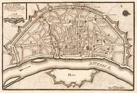
171678549Paris: 1716. A beautiful city plan of Stralsund in Germany just off the island of Rugen in the Baltic Sea. Copper engraving. Hand coloured. Sheet size: 275 x 404 mm Plate size: 230 x 332 mm Good condition. unknown
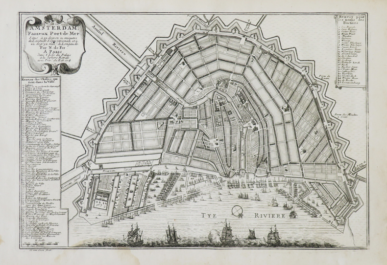
1705M5136Paris 1705. Excellent. Size : 235x350 mm 9.25x13.75 Inches Coloring: Black & White Category: Maps City Maps; Maps Europe France unknown
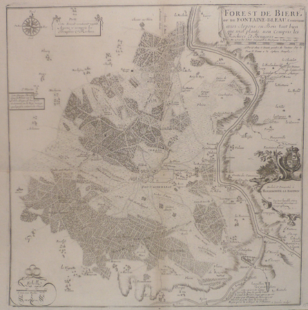
170552950Paris. 1705. An attractive map of part of Belgium showing forests and river valleys. 'de Fer's maps are popular despite or maybe because of their rather flamboyant decoration' Moreland & Bannister p130. Title at lower right. Atlas Curieux ou Le Monde. Copper engraving. Fine condition Later colouring. Size: 59 x 22 cm. Moreland and Bannister unknown
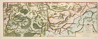
171753085Atlas Curieux ou le Monde. Paris 1717. Map of Switzerland with title at top left dedication and scales in lower corners Copper engraving. Fine condition Later colour. Size: 348 x 240 mm. 13½ x 9½ iinches unknown
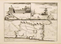
171053827Atlas Curieux ou le Monde. c.1710. The lower half of this attractive engraving shows a map of the fortifications of Lisbon. The upper half has two views- To the left the 'Palais Royal de Lisbonne' and to the right 'Le Chateau de Belem'. Copper engraving. Fine condition. Uncoloured. Size: 330 x 240 mm. 13 x 9½ inches. unknown
171778864Paris: 1717. Map of the Catholic Low Countries or current day Belgium. Published in "Atlas Curieux ou le Monde". Copper engraving. Hand coloured. Sheet size: 274 x 405 mm Plate size: 216 x 326 mm Very good condition. unknown
1704LBW0249aParis, chez l'auteur, [1704]. 232 x 344 mm + feuillet de texte.
1703LBW-61151703. 227 x 336 mm + feuillet de texte descriptif.
1705LBW02e681705 234 x 341 mm.
1705LBW027ceParis chez l'auteur 1705 237 x 349 mm.