FER, Nicolas deBiblio.com
199 résultats
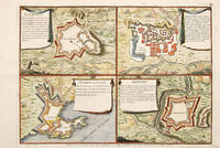
170565686Paris. 1705. An interesting and unusual map depicting the basic fortifications of two Portuguese towns. Published in the 'Atlas Curieux ou Le Monde'. Size: 275 x 395 mm. Copperplate engraving. Fine condition. unknown
1702523961702. Copper engraving. Later colouring. Size: 33 x 22 cm. 13 x 8½ inches unknown
175412504Notes de Charles Rollin.Texte en latin. Plein veau moucheté d'époque, dos longs très ornés avec un fer à l'oiseau. Très bon Paris Estienne 1754 2 volumes in-12°
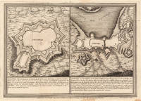
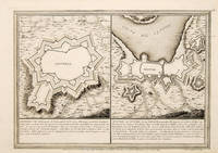
170565687Paris 1705. An unusual and interesting plan of the fortifications of four villages in Portugal. Published in the 'Atlas Curieux ou Le Monde'. Size: 275 x 410 mm. Copperplate engraving with later hand colour. Good condition. unknown
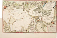
171752957Paris. 1717. Detailed map of a battle in the July of 1712 with troop placementsand positions on the map. An explanation of the battle at lower right. Accompanying text on reverse. Published in de Fer's Atlas Curieux ou Le Monde. Copper engraving. Very good condition. Upper left top and right hand margin have been trimmed close to edge of plate Later colouring. Size: 52.5 x 31 cm. unknown
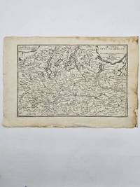
170423542Paris: N. de Fer 1704. Other. In very good condition. 244 by 345mm 9½ by 13½ inches. Copper engraving uncolored as published. N. de Fer unknown
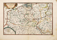
1705M1429A detailed map of Normandy also showing the islands of Guernsey Jersey and part of Brittany.<br /> From "L'Atlas Curieux ou le Monde Represente ans des Cartes Generales et Particulieres du Ciel et de la Terre..."
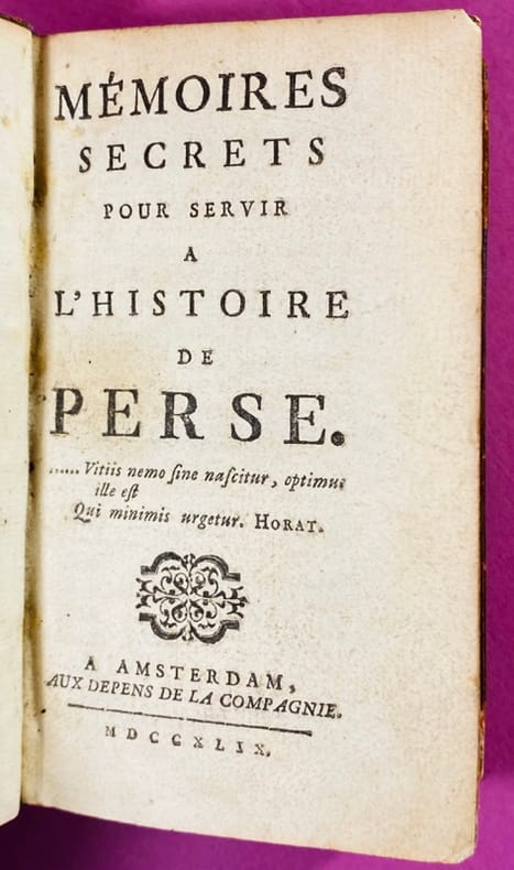
174519251745 Couverture rigide Amsterdam, aux Depens de la Compagnie, 1749. Un petit volume in-12 (13 x 8 cm), pleine basane fauve marbrée de l’époque, dos à nerfs orné de fleurons dorés, quelques épidermures et rongements sur les coupes, coiffe supérieure arasée, petit manque de cuir en pied au 1er plat. Xxij 386 pages, rares rousseurs et mouillures claires, quelques annotations au crayon, ex-libris manuscrit au 1er contreplat. 3ème édition après l'originale parue en 1745. En tête figure la clé des personnages (17 pages). On sait que dans ces prétendus Mémoires on trouve, sous des noms orientaux, un récit satirique de tout ce qui s'est passé en Europe depuis la mort de Louis XIV, pendant la Régence et pendant les premières années du règne de Louis XV. Bien des personnages, aujourd'hui fort obscurs, figurent dans ces « Mémoires » que le gouvernement de la Restauration crut devoir encore faire saisir et mettre à l'index. (Drujon). Serait d’après Barbier (III, 245) le premier ouvrage où l’on parle du Masque de fer. Bon état intérieur.
1725204942Paris: de Fer Nicolas 1725. unbound. very good. Map. Engraving with modern hand coloring. Image measures 5.25" x 6.25".<br/><br/> Charming miniature map of Denmark with the Coat of Arms incorporated in the cartouche. Map includes both Schleswig and Holstein while today part of the former and all of the latter are northern Germany. Nicolas de Fer 1646-1720 was a French cartographer engraver and publisher. He became official geographer to the French Dauphin 1691 and to the Spanish King 1702.<br/><br/> de Fer, Nicolas unknown books
1725204942Paris: de Fer Nicolas 1725. unbound. very good. Map. Engraving with modern hand coloring. Image measures 5.25" x 6.25".<br/> <br/> Charming miniature map of Denmark with the Coat of Arms incorporated in the cartouche. Map includes both Schleswig and Holstein while today part of the former and all of the latter are northern Germany. Nicolas de Fer 1646-1720 was a French cartographer engraver and publisher. He became official geographer to the French Dauphin 1691 and to the Spanish King 1702.<br/> <br/> de Fer, Nicolas unknown
1705279621705 Paris, 1705 - Blatt-Maße: ca. 27 x 38 cm. -- gut erhalten. || Original copper engraved map from 1714.
1714279611714 Paris, 1714 - Blatt-Maße: ca. 27 x 38 cm. -- gut erhalten. || Original copper engraved map from 1714.
170578550Paris: 1705. A beautiful city plan of Ulm in the federal German state of Baden-Württemberg. Copper engraving. Hand coloured. Size: 277 x 403 mm Good condition. unknown
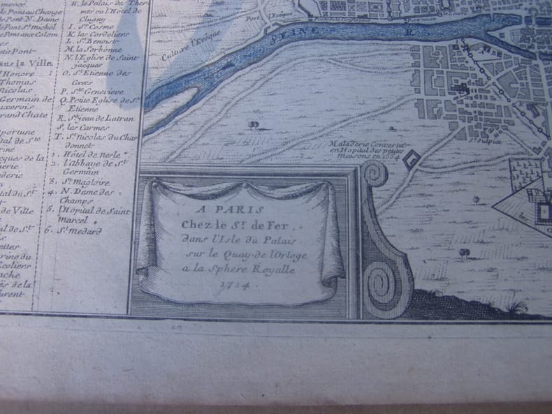
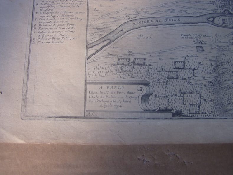
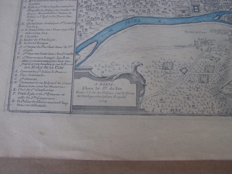
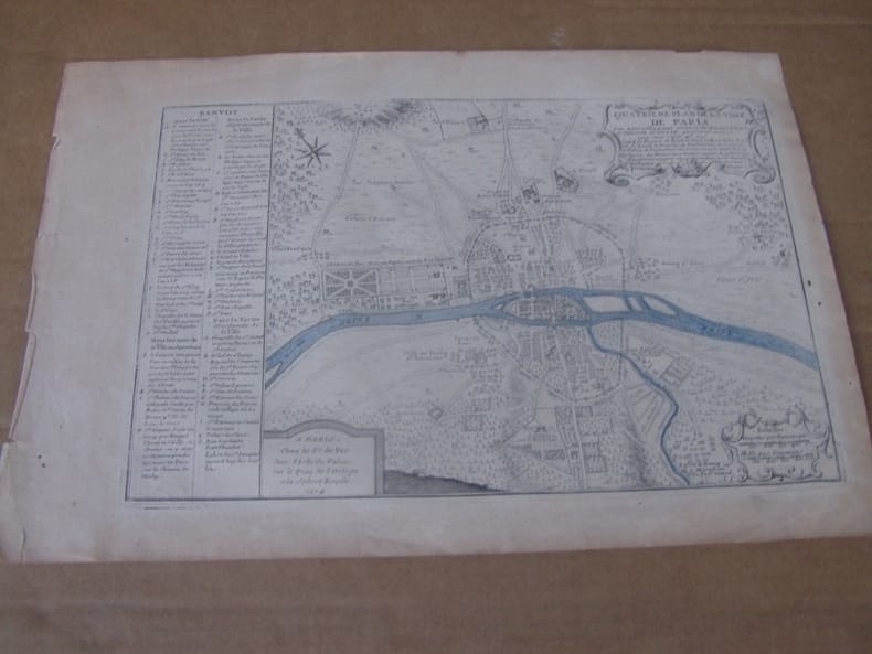
1714279171714 A PARIS Chez le Sr. De Fer, dans l'Isle du Palais sur le Quay de l'Orloge a la Sphere Royale 1714. Size with margins : 37,5 x 25,4 cm / 14,5 x 9,8 inches
1705356958Paris. 1705. Good old repair to right margin smoke stains to top margin no affecting the image short tears to lower margin. 26.5x29x0.1 cm. Image size: 21x32.2 to neatline. Uncolored engraved map of Duchy of Milan by the prolific French mapmaker. weight: 0.1 lb. unknown
171778680Paris: c.1717. Map of the towns of Dunkirk and Mardick showing the new canal. Published in "Atlas Curieux ou le Monde". Copper engraving. Hand coloured. Size: 275 x 398 mm Very good condition. unknown
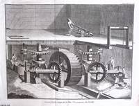
1765370549Paris 1765. Unframed Print. Very Good Condition. An original 18th century engraved print not a modern reprint. The blank unprinted margin spaces and corners are mildly creased but the image is not affected. Folded as published. There are no text pages. The size shown is the approximate image size the whole page with margins is slightly larger. The Encyclopedia a monumental work edited by Denis Diderot and Jean Le Rond d'Alembert was a groundbreaking endeavour that aimed to systematically catalogue all human knowledge spanning 28 volumes published between 1751 and 1772. As a product of the Enlightenment era the Encyclopedia embodies the spirit of rational inquiry intellectual exchange and the scientific method as its contributors known as encyclopedists sought to understand the world through reason and empirical evidence. The editors Diderot and d'Alembert defined their goal : "As an Encyclopedia it is to define as well as possible the order and structure of human knowledge. As a Reasoned Dictionary of the Sciences Arts and Trades it is to contain the general principles that form the basis of each science and each art liberal or mechanical and the most essential facts that make up the body and substance of each". The emphasis on arts and trades during the Enlightenment period shifted the focus from the refined pursuits of the aristocracy to the everyday accomplishments of working people. This movement celebrated the skills and crafts of artisans farmers and other labourers recognising their importance in society and the value of their contributions to the economy. By highlighting the applied arts and crafts the Encyclopedia promoted a more egalitarian view of society where all individuals regardless of social class had a vital role to play in shaping culture and society. Size: 32 x 43 cms. Text is in French. Category: Diderot Encyclopedia; French Language; Printed before 1800; PRINTS : Antiquarian Interest; French Language; This item may require more postage than the rates shown for delivery outside the UK. If extra postage is required we will contact you before processing your order and you will be given the details and option to decline the extra cost. unknown
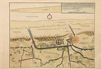
170578538Paris: 1705. Nicolas de Fer's excellent plan of the Nieuburg House where the treaty of Ryswick in the Netherlands was signed in 1697 and not 1705 as stated in the print. From the "Atlas Curieux ou Le Monde". Copper engraving. Hand colouring. Size: 275 x 400 mm Good condition. unknown
1714279201714. A Paris : Chez le Sr. de Fer, dans l'Isle du Palais, sur le Quay de l'Orloge a la Sphere Royale, 1714. Size with margins : 37,5 x 25,4 cm / 14,5 x 9,8 inches
1714279181714 A Paris : Chez le Sr. de Fer, dans l'Isle du Palais, sur le Quay de l'Orloge a la Sphere Royale, 1714.Size with margins : 37,5 x 25,4 cm / 14,5 x 9,8 inches
1750S376681750. paperback. gebraucht gut Bon état. Ein Einriss 3 cm verso fachmännisch geschlossen Papier altersbedingt leicht fleckig und geknickt sonst GUTES EXEMPLAR. 235 x 345 cm. In französischer Sprache. 112. Par N. de Fer Geog. de Sa Majeste' Catolique et de Monseigneur le Dauphin. Für Ihre Zufriedenheit versenden wir mit DHL und ausschließlich mit Trackingcode für eine sichere Sendungsverfolgung! Weitere Angebote unter antiquariat-kastanienhof paperback
1714279211714 Paris, 1714 - Blatt-Maße: ca. 27 x 38 cm. -- gut erhalten. || Original copper engraved map from 1714.
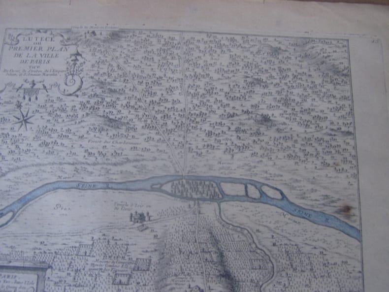
1705279321705 Date: 1705 ) de Nicolas de Fer "L'Atlas curieux ou le Monde réprésente dans des cartes. "- 356 x 240 mm - plis en marge du haut.
1714279191714 A Paris : Chez le Sr. de Fer, dans l'Isle du Palais, sur le Quay de l'Orloge a la Sphere Royale, 1714.Size with margins : 37,5 x 25,4 cm / 14,5 x 9,8 inches