Yee, Lydia & Briony FerBiblio.com
11 843 résultats
2016120328Gallery. New. 2016. Hardcover. 0854882472 . FREE UPGRADE to Courier/Priority Shipping Upon Request - IN STOCK AND IMMEDIATELY AVAILABLE FOR SHIPMENT - Flawless copy brand new pristine never opened. -- with a bonus offer-- . Gallery hardcover
2016120895Gallery. New. 2016. Hardcover. 0854882472 . FREE UPGRADE to Courier/Priority Shipping Upon Request - IN STOCK AND IMMEDIATELY AVAILABLE FOR SHIPMENT - Flawless copy brand new pristine never opened. -- with a bonus offer-- . Gallery hardcover
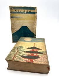
192686404Tky Tokyo: Hakubunkan 1926. Fine. Hakubunkan Tky Tokyo 1926 19.50 x 11 cm relié Work published by the Japanese Ministry of Railways admirably illustrated with 166 illustrations. This new edition was entirely revised and the illustration is completely new. The Ministry of Railways published this collection from 1923 to 1928; from 1923 to 1925 the collection contained numerous bird's-eye view maps by Yoshida which were replaced by photographs and now only adorn the pastedowns. This is the first collection to use photography with 126 black and white photographs and 18 hand-colored ones. 22 color prints by Hatsusaburo Yoshida. 7 folding color maps and several black and white maps in-text. Cloth binding and cardboard slipcase. Pale green cloth covers. Smooth spine with title. Boards printed with a Japanese temple with full moon and trees on the first board and on the second. Illustrated cardboard slipcase with Mount Fuji and birds. Rubbing and dulled edges to the slipcase. Small cut to the cloth on the spine. Fine condition of the collection with some foxing. Spine darkened boards spotted. Handsome copy rare with its original slipcase. A vast undertaking this guide was intended as a monument to the glory of Japan. For the first time modern Japan meets traditional Japan. Celebrated as the Hiroshige of the Taisho era Yoshida 1884-1955 was a painter and cartographer. A major retrospective of his works took place in Japan at the Sakai Museum in 1999. The prints created for this collection are particularly beautiful. Hakubunkan hardcover
192485112Hakubunkan | 1924 | 19.50 x 11 cm | broché
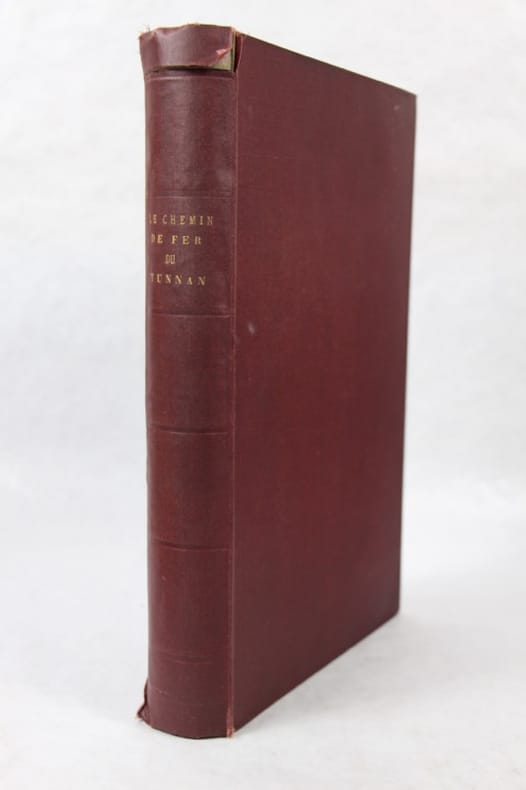
191047657Paris, impr. de G. Goury, avril 1910 1910 In-folio, pleine percaline, couverture sup. ill. cons., 202 pp. 84 planches photographiques à multiples vues, certaines en couleurs. Panorama frontispice en couleurs sur papier gaufré Laokay, Cok-Leu et Hokéou, au confluent du Fleuve rouge et du Namti-Hok, origine de la ligne du Yunnan, carte en couleurs, fig. dans le texte. Petite déchirure sans manque en haut du dos. Bon exemplaire. Sans le volume de planches.
187820520Paris Administration Des Chemins De Fer 1878 Grand In-folio ( 62,5 X 46,5 ) 15 doubles feuillets représentant 15 cartes de chemins de fer y compris une carte des chemins de fer des deux Amériques et une carte des chemins de fer de l'Algérie, soit 16 Cartes en tout Galeries de vers en marge et atteinte à la carte de l'amérique du sud , ) Très Nombreuses publicités entre les cartes. Les cartes sont consacrées essentiellement au chemins de fers Français et Européen, Etonnante carte des chemins de fer tucs et russes; Format spectaculaire, très grand intérêt de cet atlas désormais restauré
ST2Années 1978, 1979, 1980, 1981, 1983, 1985 à 1988, 1990 à 1910, 1912. 85 volumes de texte ou planches. En supplément environ 300 revues années 1930 à 1960.
1722152321722 reliure plein veau havane in-quarto carré (binding full calfskin in-quarto), dos 5 nerfs (spine with 5 raised bands) - entre-nerfs à double filets or à fleuron au fer évidé et rinceaux aux angles avec des petits fers en remplissage (between the raised bands double gilt lines - floweret with hollowed out blocking stamp - with foliages executed in the curved lines in angles - with small blocking stamp in filling) - pièce de titre comportant le titre abrégé de l'ouvrage sur fond havane clair (label of the title with the title abbreviated by the work) - rinceaux en tête et en pied (top and at the foot of spine with foliages carried out with the curved line), petits manques de cuir sur le dos (missing pieces of leather on the spine), coiffe supérieure légèrement accidentée (head of the spine damaged), coiffe inférieure manquante (is missing tail of the spine), charnière du quatrième plat fortement épidermée jusqu'au carton (joint of the back cover with strongly scratches up to the cardboard), coins de queue fortement écornés (corners of the bottom strongly dog-eared), roulettes à froid sur les coupes (fillets with blind-stamping decoration on the cuts), toutes tranches peignées (all painting edges), pages de garde peignées (painting endpapers), texte à manchette (marginal note), illustrations : orné de bandeaux - lettrines et de culs-de-lampe et gravures hors-texte (illustrations : illuminated of headpieces and dropped initials and of tailpieces and illustrations full page engravings), cicatrices de mouillures (scars of waterstains), galeries de vers en particulier en fin d'ouvrage atteignant le texte mais sans conséquence sur sa compréhension (worm's gallery in particular at the end of work on the text but without consequence on its understanding), 9 feuillets de pièces liminaires (9 leaves of introductory pieces) + 566 pages + 1 feuillet (1 leaf), 1722 à Paris Chez Michel Brunet - Grand'Salle du Palais au Mercure Galant,
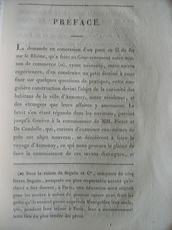
1023In 8 broché couverture papier bleu d’attente.Faux-titre, titre,VIII,Avis 2feuillets,103 pages.1 page de table.5 planches dépliantes.Louvet graveur.Chez Bachelier Libraire 1824.grandes marges.Très rare édition originale Seguin traite des origines des ponts suspendus, des cordes verticales des parapets,et amarres inférieures du pont,des planchers.Bibliotheca Mechanica,293.
186278773New York:: Francis Hart & Co. 1862. First edition. publisher's gilt-lettered and blind-embossed cloth. Small marginal chip to one map; cloth a little sunned; a beautiful clean tight and sound copy. . Folio. Decorative half-title page; engraved illustrations throughout; one double-page and one folding double-page map; engraved decorative borders throughout. . Francis Hart & Co., hardcover
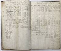
1841754Pittsburgh 1841. About very good. 48pp. Large folio. Contemporary half reverse-calf and blue paper boards. Wear to corners and spine ends boards soiled. Leaves reinforced at gutter margin with tape some light soiling. In a clear and legible hand. This ledger records the register and pay information for approximately thirty-five men who worked at the Birmingham Iron Works from 1836 to 1841. The "Register of Hands That Work by the Ton" records each man's name his wage days worked how much tonnage and his job description. The Iron Works supported an engineer a blacksmith a watchman refiners heaters carters rollers puddlers bricklayers and some men simply described as laborers. The number of employees varies from year to year ranging from thirty to forty-five or so with many men listed as steady employees year after year. Also tucked in the front of the volume is a slim gathering of sheets labeled in manuscript as "Balance of Property Debts Goods & Chattels of the firm of Hoge & Hartman Iron Manufacturers Pittsburgh Jany. 2nd 1840." This lists receivables and debts for that company which was one of several iron works in the area by 1840. Located south of the Allegheny near 16th Street the Birmingham Iron Works was founded in 1836. It had twenty single puddling furnaces five heating furnaces and produced bar iron rounds hoops bands and other forms of iron. There works were active from 1836 to 1871 and averaged 9000 tons of production per year. This ledger therefore encompasses the first years of its operation and is an early record not only for the company but for the region in terms of iron production which would eventually lead to the steel boom that made Pittsburgh prosperous -- and Andrew Carnegie insanely wealthy. An excellent source for the labor history of the steel industry in Pittsburgh. unknown books
1868173873Lille: Imprimerie de L. Danel 1868. Limited to 25 copies. Good overall the silk endpaper has lifted from the corner. 3/4/ black leather with 6 raised bands and gilt title second compartment. Purple silk endpapers and pastedowns. T.e.g. Title-page with large gilt-decorated emblem device above imprint. 3 preliminary leaves 7-97 2 pages mounted portrait. Preliminary states "Recueil des Discours Pronounces sur la Tombe du Baron James De Rothschild et des principaux articles de journaux publiées à l'occasion de sa mort et de ses funéreailles Ce Recuei tire vingt-cinq exemplaires est offert A Madame La Baronne James De Rothschild et a sa famille par le personnel du Chemin de fer du Nord." Includes funeral sermons and obituaries published in Le Temps Journal des debats L'Epoque and other perodicals. The photograph shows the Baron as he appeared in 1864. Worthy of restoration and exceedingly scarce. Worldcat locates 4 copies including 1 in the United States. Imprimerie de L. Danel hardcover
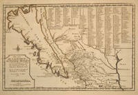
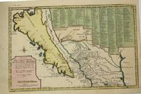
170015901Paris 1700. Early original color large map of California showing it as an island and based on the explorations of missionary Father Kino. From De Fer's Atlas Curieux. In great detail with 314 locations in New Mexico identified by a numbered key at the upper right portion of the map. Engraved by Charles Inselin. mage size: 13 1/2 x 8 7/8". Paper size: 16 1/2 x 11 1/2". With a small chip at lower edge; very faint damp staining at upper left corner toning to edges; otherwise very good. Tooley R. V. Amer P 126-7. unknown
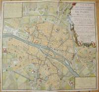
1735M7483Paris c.1735. Very Good;. Notes: Large scale decorative 18th century map of Paris. Top right title in a cartouche adorns a fountain spewing water referring to the establishment of the network of fountains in the capital. Size : 565x590 mm 22.24x23.23 Inches Coloring: Hand Colored Reference: Jean Boutier #212A Category: Maps Europe France Paris;Maps City Maps; unknown
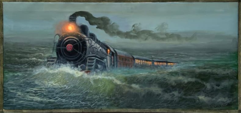
2024250222024 Huile sur toile signée en bas à droite, 2024, 45 x 100 cm., encadrée d'une baguette bois.
192686404Hakubunkan | T?ky? 1926 | 19.50 x 11 cm | relié
1671LBW-5776Paris, A. de Fer, 1671. 380 x 525 mm.
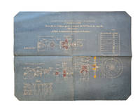
189159258(Loire, Saint-Chamond, 1891). Folio. 45 technical drawings, most printed and hand-coloured on blue paper. All plates depicts the ""Tourelle à éclipse pour canon 1 Canon de 75 m/m á tir rapide"". Sizes vary from 75x36 cm to 101x73 cm. All housed in contemporary portfolio, front board detached. All plates with stamp and nubering in contemporary hand. Plates fine and clean.
189159258Loire Saint-Chamond 1891. Folio. 45 technical drawings most printed and hand-coloured on blue paper. All plates depicts the "Tourelle à éclipse pour canon 1 Canon de 75 m/m á tir rapide". Sizes vary from 75x36 cm to 101x73 cm. All housed in contemporary portfolio front board detached. All plates with stamp and nubering in contemporary hand. Plates fine and clean. <br/><br/><em>Collection of techincal drawings of Saint-Chamond's fast 75 mm canon. The Compagnie des forges et aciéries de la marine et d'Homécourt FAMH Company of marine forges and steelworks and of Homécourt was a French industrial enterprise that made iron and steel products for the French navy army and railroads. It is often known as Saint-Chamond from its main location in Saint-Chamond Loire. </em> unknown
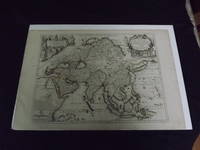
1722biblio10<p>Engraved double page map 28" x 20" wide margins hand colored in outline two uncolored pictorial cartouches. Expert and nearly invisible repairs along centerfold normal aging; about near fine. Impression is bright and clean. Nicholas De Fer 1646-1720 was a highly respected and prolific French cartographer whose maps were valued for their decorative appeal. Around 1690 he was made the geographer to the Dauphin and published his first atlas. He would become geographer to other high-ranking individuals in French and Spanish society. The present map is detailed and attractive map of Asia with a cartouche showing Chinese at the upper left and Indians in the upper right. The map covers a lot of territory showing Arabia and the Persian Empire in the West and Japan in the east but goes as far south as the Isle of Borneo and Java. Part of Eastern Europe is also visible. Library missouri website.</p> books
1722biblio10<p>Engraved double page map 28" x 20" wide margins hand colored in outline two uncolored pictorial cartouches. Expert and nearly invisible repairs along centerfold normal aging; about near fine. Impression is bright and clean. Nicholas De Fer 1646-1720 was a highly respected and prolific French cartographer whose maps were valued for their decorative appeal. Around 1690 he was made the geographer to the Dauphin and published his first atlas. He would become geographer to other high-ranking individuals in French and Spanish society. The present map is detailed and attractive map of Asia with a cartouche showing Chinese at the upper left and Indians in the upper right. The map covers a lot of territory showing Arabia and the Persian Empire in the West and Japan in the east but goes as far south as the Isle of Borneo and Java. Part of Eastern Europe is also visible. Library missouri website.</p>
1705M5240Paris c.1705. Very Good. Notes: “California with indented northern coast and labeled: Californias o Carolinas. New Mexico is shown covered with engraved key at may top right. Includes Father Kino’s Place name Co. S. Francisco Xavier at California’s northern tip†McLaughlin<br><br>The title Ba. d. las 11000Virgenes is introduced for the first time. In the Southwest there are names such as Santa Fe Acoma and Casa Grande. The key covers 314 different places and their locations. Size : 230x345 mm 9x13.625 Inches Coloring: Hand Colored Reference: McLaughlin 134; Tooley Amer 62; Wagner 462. Category: Maps United States West California; Maps Central America Mexico; unknown
9892Paris, Imprimerie Goury, Avril 1910. 1 fort volume in folio, 45 pp. de texte, reliure percaline d'éditeur, couvertures illustrées conservées, richement illustré de reproductions photographiques à pleine page. Excellent état. Il existe une autre version de cet ouvrage, dont le texte est enrichi (202 pp.).