De Fer, NicolasBiblio.com
2 067 résultats
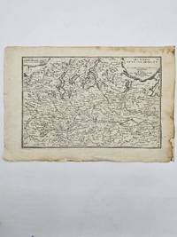
1705356958Paris. 1705. Good old repair to right margin smoke stains to top margin no affecting the image short tears to lower margin. 26.5x29x0.1 cm. Image size: 21x32.2 to neatline. Uncolored engraved map of Duchy of Milan by the prolific French mapmaker. weight: 0.1 lb. unknown
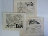
1700002589Paris 1700. Desencadernado / Disbound. Muito Bom/Very Good/Très Bien. 325 x 240 mm. A. Coquart Sculp. Fina gravura em chapa de cobre colorida a aguarela inserida no "Atlas Curieux ou le Monde Cca 1700. Representando três vistas de Lisboa em diferentes cartuxos: Uma vista razante do terreiro do Paço com a representação do antigo paço e do Convento de S. Domingos com uma vista do cais e do terreiro onde se desenrrolam cenas do quotidiano nomeadamente uma cena de equitação. Uma vista da Torre de Belém rodeada de barcos e navios e Uma planta das fortificações da cidade com identificação do castelo e do Palácio Real identificando um pântano "marais" ao norte da fortificação. Apresentada num passpartout de cartão pronta para encaixilhar. <br/> <br/> unknown
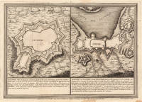
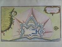
1693bp47Paris 1693. No Binding. Good. copper-plate print. uncoloured. fortification and Church jutting into mediterranean. cartouche with cherub like individuals and a sheep. Our orders are shipped using tracked courier delivery services. Paris unknown
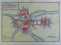
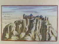
2n1773De Fer Paris um 1700. Maße: 27 cm x 19 cm Blattrand mit kleinen Knickspuren. - Nicolas de Fer war einer der führenden französischen Kartographen und Kartenverleger - unknown
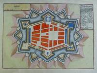
170423542Paris: N. de Fer 1704. Other. In very good condition. 244 by 345mm 9½ by 13½ inches. Copper engraving uncolored as published. N. de Fer unknown
2n1617ca. 1694. Blattgröße: 365 cm x 275 cm. kräftige Abdrucke / saubere Blätter - unknown
2n1776De Fer Paris um 1700. Maße: 285 cm x 205 cm. - Nicolas de Fer war einer der führenden französischen Kartographen und Kartenverleger - unknown
17008374Paris 1700. Copper engraving 22.5 x 33.5 cms engraved by C. Inselin black and white slight soiling bottom right blank verso; the key lists 113 places of interest. This is the first version of the map before the date was amended. Howgego Printed Maps of London 44 1 unknown
2n1785De Fer Paris um 1700. Maße: 28 cm x 165 cm. - Nicolas de Fer war einer der führenden französischen Kartographen und Kartenverleger - unknown
2n1777De Fer Paris um 1700. Maße: 23 cm x 175 cm Blattrand gering fleckig und mit kleinem Einriß. - Nicolas de Fer war einer der führenden französischen Kartographen und Kartenverleger - unknown
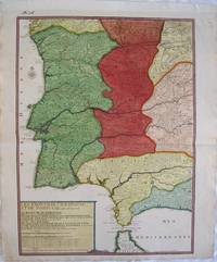
2539Europe: Paris de Fer. N 1705. Copper engraved map of Portugal and part of Spain by Nicholas de Fer from his "Atlas ou Recueil de Cartes Geographiques" Original old full wash colour; verso blank. The map shows the south western part of the Iberian peninsular: Portugal; the Algarve and parts of the kingdoms of Estramadura AndalusiaGrenada Leon and Castille extending down to the straits of Gibraltar. Good dark impression; colours bright; old ink number to upper blank margin; guard attached to upper margin; light diagonal creases towards centre fold other small printers creases/ wrinkles to centrefold; old ink title to verso. Nicholas de Fer 1646 - 1720 was the son of cartographer Antoine de Fer. Nicholas was established as an engraver cartographer and map publisher in Paris. De Fer was a prolific cartographer with over 600 maps and atlases to his credit. De Fer's work though replete with geographical errors earned a large following because of its considerable decorative appeal. In the late 17th century De Fer's fame culminated in his appointment as Geographe de le Dauphin a position that offered him unprecedented access to the most up to date new cartographic information. He would later be appointed Geographe de Roi to the kings of both France and Spain. Pastoureau FER II C 72. Europe Spain & Portugal Portugal Paris de Fer. N 1705 unknown
2037Americas: Paris de Fer Nicolas 1704. Copper engraved map of Martinique from Nicolas de Fer's "Alas Curieux" Original colour; verso blank. Detailed map engraved by P Starckman with long key identifying 63 places of interest Dark impression; upper margin trimmed to plate mark; crease to lower right corner;ink number to upper right corner. Nicolas de Fer 1646-1720 was the son of Antoine de Fer also a map engraver and colourist in his own right who had worked with Nicolas Berey and acted as an editor for Pierre Duval's "Cartes De Geographie ." of 1657. Nicolas began his career with an apprenticeship to the engraver Louis Spirinx in Paris. It soon became clear that his interest lay in the production of current maps recent discoveries and he was particularly interested in the topical production of military maps with town plans and their fortifications an especial interest. De Fer's first map was published in 1669 and was a rather unusual map of the Languedoc Canal with a phonetic title. Antoine died in 1673However it wasn't until 1687 that Nicolas took over the running of the family business. Over the next few years De Fer was able to make the publishing business flourish and in 1690 he was nominated as geographer to the Dauphin – their relationship had reciprocal benefits with De Fer producing in effect royal propaganda concerning the Dauphin's lands with each publication enhancing his own name and reputation as well as that of the Dauphin. When the Duke of Anjou ascended the throne in 1702 De Fer had the dual title of "geographe du roi d'Espagne et du Dauphin". De Fer published a number of atlases including the "Cotes de France" of 1690 containing Tassin's maps and the "Forces de l'Europe ou Introduction a la fortification" also of 1690 that reinforced his abilities and success with the buying public. Subsequent publications included the "Petit et Nouveau Atlas" which appeared in 1697 followed by the "Atlas Curieux". The "Atlas Curieux" was well-known and popular being expanded in successive editions between 1700 and 1705 and was re-edited in 1714 and 1716 under the title "Suite de l'Atlas Curieux". De Fer also produced a number of folio maps that appeared in the "Atlas ou Recueil de cartes" which was published in 1709. Americas Caribbean Martinique Paris de Fer, Nicolas 1704 unknown
2n1788De Fer Paris 1705. Maße: 19 cm x 122 cm. - Nicolas de Fer war einer der führenden französischen Kartographen und Kartenverleger - unknown
JOURN0077NEW. NEW. Enviamos a todo el mundo por USPS. UPS o DHL. 100% garantia en su compra. We ship worldwide. unknown
2020x-8417949151Lippincott Williams & Wilkins 2020. Paperback. New. 5th edition. 301 pages. Spanish language. 7.00x4.25x0.50 inches. Lippincott Williams & Wilkins paperback
ING9788417949150LWW. New. Special order direct from the distributor LWW unknown
2018__1975113284Lippincott Williams & Wilkins 2018. Paperback. New. 5th pck pap/ edition. 301 pages. 7.25x4.25x0.75 inches. Lippincott Williams & Wilkins paperback
1629154466.Gpaperback. Good. Access codes and supplements are not guaranteed with used items. May be an ex-library book. paperback
51830Eds Flammarion In-4-carré 27 cm 192pp. illustr. photographies reliure cart. de l'éditeur avec jaquette Nb-0159 unknown
201310268JRP Ringier 2013. Hardcover. Near Fine/Very Good. Folio in orange cloth. Boards crisp and unworn; interior clean and crisp; light wear to jacket small dampstain to jacket front panel at top. Due to size or weight of book additional charges for international and priority shipping may apply. Folio - over 12 - 15" tall. JRP | Ringier hardcover
0310608813.Gpaperback. Good. Access codes and supplements are not guaranteed with used items. May be an ex-library book. paperback
20122-8467715316Susaeta 2012. Hardcover. New. illustrated edition. 253 pages. Spanish language. 10.75x9.25x1.50 inches. Susaeta hardcover
0265796490.Ghardcover. Good. Access codes and supplements are not guaranteed with used items. May be an ex-library book. hardcover
2009Adhya-9783642044465SPRINGER 2009. Paperback. New. SPRINGER paperback
2009Adhya-9783642044465SPRINGER 2009. Paperback. New. SPRINGER paperback