[JAPANESE WORLD WAR II BOARD GAME].Biblio.com
119 846 résultats
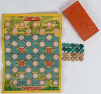
1940216804Japan. Circa 1940. Colour folding game sheet 36.5 x 26cm 10 wooden playing pieces each with embossed images in beige and blue complete original box 15.5 x 7.6 x 2.3cm considerably worn and soiled and corners reinforced the game itself is in very good bright condition. This is a two-player board game where air planes and war ships fight against each other. Fascinatingly the game sheet illustration shows the battle ground is in the Pacific where islands with palm tree are dotted. Consequently the game might be produced at the early stage of the Pacific War. The players attack each other after starting from a naval base and an air base. There are two islands each where they are safely protected from their enemies. The playing pieces are made out of paper with embossed images of war ships and air planes in beige air power and blue sea power colours. . unknown
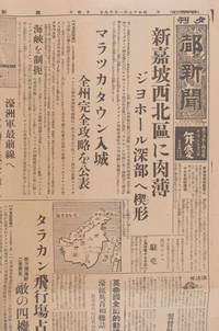
1572159803東京. Tokyo.: 都新聞社.Miyako shinbunsha. 昭和十七 1942. Double sided newsheet browned with a few small holes folded. Good copy. 54 x 40.2cm. WWII Japanese newspaper one sheet printed double side issued by Miyako Shinbunsha on January 18th 1942. Front page features latest military news including Japanese army's advances in Johore State and capture of Malacca town to the northwest of Singapore on January 15th. These is also a report on the capture of Tarakan airfield and on bombing raids launched against Rabaul. It also shows two maps one of Borneo and one of the war zone of southern Malaya Singapore and northern Sumatra. One article highlights the fact that Australian newspapers including Sydney's Daily Mirror have been critical of the failures of British Military strategy in Southeast Asia. Another entitled "Australian Army to the Front Line" describes the deployment of Australian forces to Southeast Asia to oppose Japan's southward advance. <br> <br>There is also an article on page 2 about marriages of Japanese military settlers in Manchuria. Not all of the reports are war related - the newsheet includes reports of sumo results and advertisments for patent medicines. Occasional closed tears at edges and trifle losses otherwise in good condition. Text in Japanese. . 都新聞社.[Miyako shinbunsha]. unknown
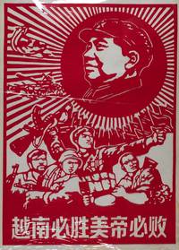
160398No publication details. No date. Late 20th Century. Large Chinese Vietnam War papercut on red paper with paper backing. Lower section features four soldiers in uniform looking fiercely towards the enemy while carrying weapons like machine guns and grenades. Upper right section Mao's head and collar portrait the sun with its bold rays extending behind him red flags flying underneath the beaming sun military aircrafts and a tank also featured next to Mao's portrait. Very good. Text in Chinese reads "Vietnam Must Win and US Imperialism Must be Defeated" sheet measures 70 x 50.3cm. . No publication details. unknown
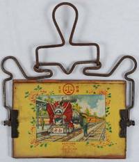
1940224121Shanghai.: 上海裝鏡工業第二联營所. Shanghai jinggongye di'er lianyingsuo. Circa1940s - 1950s. Mirror with attached coloured image on paper under glass on reverse 10.5 x 15cm metal handle 15.5 x 17.5cm. Mirror a little stained and clouded at edges image browned at edges hanger rusty but still very functional. An interesting piece of 1950s propaganda. This portable travel mirror is a useful and decorative example of the sort of mass produced consumer items made in the early 1950s in small local workshops that were organised into collectives. Travel mirrors could be hung up or propped up for use by a moveable handle. On the reverse is a colour socialist-realist illustration of a red flag-draped locomotive a symbol of modern progress patriotism and peace. The colourful image of the train with its 天平商标 logo could be displayed when not in use or replaced with a photo with the mirror behind it. <br> <br>In 1952 when China built its first domestically designed locomotive it was called the "Peace" series which we see written on the front of this engine with the image of a dove. China's involvement in the Korean War to 'resist US aggression and assist Korea' depended on strong logistical supply lines to the front. Trains therefore became symbolic of national unity strength and China's ability to protect regional peace. Many such travel mirrors were bought as gifts and given as morale boosting items to the Chinese troops who could insert family photographs under glass on the backs of their travel mirrors. . 上海裝鏡工業第二联營所. Shanghai jinggongye di'er lianyingsuo. unknown
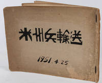
1951218840Japan. 1951. Eight black and white photographs 20.5 x 25.5cm each captioned in Japanese the handmade album is titled and dated in ink 23.5 x 32.8cm 9pp cord ties. One photograph has been removed card leaves and covers are browned surface of upper cover abraded in places some other minor wear but the photographs are in very good condition. A private album containing eight high-quality large-format photographs showing US forces being welcomed to the northern Japanese city of Muroran Hokkaido on 25 April 1951 - at the height of the Korean War. The first two photos show the US forces being welcomed by a local brass band. There is then a shot of US officers and Japanese officials standing under a large sign saying "Welcome Thunderbirds - Muroran City" indicating that the troops being welcomed are from the 45th Infantry Division nicknamed the Thunderbirds one of two US Army National Guard units engaged in the Korean War and recruited largely from the state of Oklahoma. <br> <br>The 45th Infantry Division received their initial training for combat in Korea in the US itself in 1950 and then sailed from New Orleans to Japan in early 1951 arriving at the ports of Otaru and Muroran in Hokkaido April of that year. From there they were sent for further training at Camp Crawford a US military base on the outskirts of the city of Sapporo and at a newly created camp south of Chitose before being transfered to Korea in December 1951. The album also contains two photos of the ships "General C.G. Morton" and "General William Weigel" which were built during World War II and used as a troop transport ship during the Korean War and were presumably among the ships which brought the 45th Infantry Division to Japan. Other images show local officials explaining the geography of the region to US officers as they peruse a large map and a Japanese woman beign presented with a badge by an American officer. <br> <br>Muroran was one of many Japanese ports whose life was transformed by the mass arrival of UN mostly American forces during the Korean War although the town's role in the war is less well documented than the roles of ports like Yokohama Kobe and Sasebo. These pictures give a vivid impression of the Korean war journeys of US troops and of Hokkaido during the Korean War. . unknown
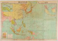
1942177492Japan. 1942. Colour map 21 x 50.5 cm centrefold as issued. Faint dampstain to upper edge centrefold a little browned. Good copy. Map of Southeast Asia including Borneo and the Philippines and New Guinea. Of particular interest is the small inset map of Singapore at lower left. The war situation of the Japanese army in 1941 and 1942 during the Pacific War is clearly shown with one sheet. Text in the inset plan of Singapore says "Occupation of Singapore in February 15 1942". . unknown
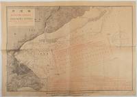
1905219989Japan.: 水路庁 Suirochō. Meiji 38 1905. Chart printed using black and red ink 37.7 x 53cm captions and charts in Japanese and English. A little minor creasing very good. This chart of the Yokohama offing records the positioning of warships during the fleet review held on 23 October 1905. Attended by the Meiji Emperor the review was staged by the Imperial Japanese Navy to celebrate Japan’s victory over the Russian Baltic Fleet at the Battle of Tsushima. It was one of the largest fleet reviews in Japanese history with more than 160 vessels taking part including several British ships. The chart incorporates diagrams and tables in both Japanese and English and clearly indicates the positions of the Emperor’s vessel alongside those of the participating warships. . 水路庁 [Suirochō]. unknown
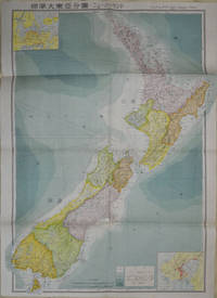
1572154080Tokyo: 統制社Tosei-sha. 昭和18 Showa1943. Folding colour map of New Zealand with inset of Auckland and Wellington top and bottom corners1:2000000 scale little light browning. Original envelope worn with closed tears. 54 x 76.5cm. Good copy. Scale plan of New Zealand printed by Tosei in 1943. The map legend shows infrastructure deemed important to the Land Survey Bureau of the General Staff Headquaters of the Imperial Japanese army such as boundaries powerlines quarries and mines; railroads sea-routes etc. . 統制社(Tosei-sha) unknown
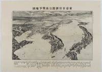
1904216054東京. Tokyo.: 東京日日新聞. Tōkyō Nichinichi Shinbun. Meiji 37 1904. Folding black and white bird's-eye view map 39 x 55cm a little worming. Good copy. This map of the Russo-Japanese War was published on 7 June 1904 by Tokyo Nichinichi Shinbun. The map featuring geographical elements is notably distorted to include Japan Korea China and distant Russia. Place names are visible in various locations and Japan appears disproportionately large in comparison with other regions. Around the time of publication the seizure of Port Arthur was underway depicted with numerous warships positioned outside the port. Distances from Port Arthur to other major cities as well as sea distances from Nagasaki to various locations are listed at the lower edge of the map. . 東京日日新聞. [Tōkyō Nichinichi Shinbun]. unknown
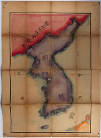
223691Henan. Colour manuscript map of Korea made in Puyang Middle School in 1954 109 x 78cm text in traditional Chinese characters the map which was originally folded has been laid down on heavy gauge paper. Chipped in a number of areas at folds some recent colouring has modified the impact of this loss. While showing signs of use this map is an interesting example of classroom teaching material relating to Korea in 1950s China. The map depicts the principal geographical areas of Korea Japan and the People’s Republic of China. The 38th parallel is clearly marked along with a number of important Korean cities including Hanseong Seoul Kaesong Busan Jinju Incheon and Pyongyang here written as 平垠. Korea is labelled as Chaoxian 朝鮮 the term commonly used in China at the time. <br> <br>Taken together with the naïve style of calligraphy and the note that it was produced at a middle school Puyang Zhongxue 濮陽中學 in Henan Province shortly after the Korean War it is likely that the map was made by a student possibly named Guo Renwen 郭人文 whose name appears at the lower right. The faint yellow numbers 1–5 painted on the map may refer to a legend or explanatory key that is no longer present. . unknown
1718159896Tokyo: Asahi shinbun. Showa 17. January 181942. 4 page broadsheet newspaper folded evenly browned. Maps black and white photographic illustrations very good copy. 54 x 41cm. Main headline: "Closing in on Singapore Vanguard: Rear-guard of Defeated British Army Cut Off; Battle of Annihilation in Johor". Other headlines include: "Occupation of Strategic Territory of Batu Anam; Australian 8th Division Crushed" followed by an account of fighting between Japanese and Australian forces in Malaya; "Main Enemy Position Cut Off: Battle of Annihilation on the Bataan Peninsula Heats Up"; "Steady Advance by Road: Imperial Army's Fierce Attack on West Coast" followed by account of Japanese advances in Malaya with map; "British Cabinet Restructured"; "US Said to Be Sending Troops to Northern Ireland". Front page has photos of Japanese soldiers standing in front of the monument to Jose Rizal in Manila and of a column of Japanese soldiers advancing by bicycle along a road on the Bataan Peninsula. Articles on the inside pages include discussions of plans to increase production of shipping to meet war needs and of a meeting of Latin American countries to discuss the world situation. Several articles on the back page emphasise material and spiritual preparations being made in Japan for a "long war". The back page also includes an interesting article criticizing US and British propaganda and "misreporting" of the war situation. All text in Japanese. . Asahi shinbun. unknown
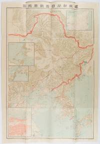
1904216818東京. Tokyo.: 電報新聞社. Denpō Tsūshinsha. Fifth Edition. Meiji 37 1904. Colour folding map with four inset maps 78.2 x 54.5cm folds into light card covers measuring 21 x 14cm. Very good copy. This the fifth edition of this map was published on 7th June 1904 reflecting the high level of public interest in receiving up-to-date information on the war particularly while the siege of Port Arthur continued without a decisive Japanese victory. The map includes four inset maps among them detailed views of Port Arthur and Vladivostok. It also records distances between key ports in Japan Korea and China. . 電報新聞社. [Denpō Tsūshinsha]. unknown
1904214704京都. Kyoto.: 打田平次郎. Uchida Heijirō. Meiji 37 1904. Colour folding sugoroku game sheet 54 x 79cm some mild wear and occasional spotting a prior owner's name and address on reverse good copy. This sugoroku game sheet on the fall of Port Arthur was published on 1 December 1904 before the actual fall took place clearly with an optimistic expectation of victory. The game begins with the Battle of Chemulpo Bay and follows the progress of the war across different locations. Although the illustrations depict both Japanese and Russian troops Japanese victories are frequently emphasised. The game had educational and propagandistic effects helping family members learn place names and battles. . 打田平次郎. [Uchida Heijirō]. unknown
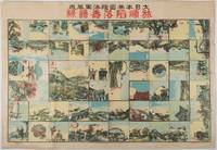
1910214342名古屋. Nagoya.: 澤田文精社. Sawada Bunseisha. 1910. Single sheet folded in two Japanese text and plan of the exhibition reverse blank 12 x 16.5cm light creasing few small closed tears at margins otherwise very good. This small brochure highlights the Port Arthur Sea Battle Exhibition Hall a pavilion featured at the 1910 Kansai Fuken Rengo Kyoshinkai 10th Kansai Prefectural Joint Exposition held at Tsurumai Park in Nagoya from March to June 1910. Attracting over 2.6 million visitors the exhibition showcased diorama models of the battle operated by newly imported electrical machines from the United States. The brochure emphasises the immersive experience suggesting spectators would feel transported to the heart of the conflict. Entrance fees are also listed. Notably Edogawa Ranpo the famed mystery writer visited the exhibition in his youth and was deeply impressed by the displays. . 澤田文精社. [Sawada Bunseisha]. unknown
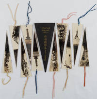
1910221129Japan. Circa 1910. Ten bookmarks with light cord ties each a silver gelatine photograph most showing scenes around Port Arthur but in one case captured Russian soldiers all captioned in Japanese.15.3 x 6.3cm. Presented in a black card envelope titled in gilt. A very good set. These ten book marks feature black and white photographic illustrations of battle grounds and war monuments in Port Arthur to commemorate the Japanese victory over Russia in the Russo-Japanese War. Some photographs show memorial towers for the dead Japanese soldiers. One of the photographs shows General Nogi and General Stossel at the time of surrender negotiation in January 1905. Each book mark has a Japanese caption printed. . unknown
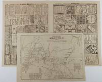
1904216797大阪. Osaka.: 大阪毎日新聞社. Ōsaka Mainichi Shinbunsha. Meiji 37 1904. Two black and white newspaper maps issued in the Ōsaka Mainichi Shinbunsha one pictorial with accompanying text and adverts printed on newsprint folded. 39.5 x 55cm Very good condition. This pictorial map of Port Arthur and Dalian was published on 4 July 1904 by the Osaka Mainichi Shinbun as a supplement. It shows Port Arthur encircled by Japanese naval vessels while Dalian is depicted as being occupied by Japanese troops. On the reverse there is an essay on the war accompanied by illustrations of Russian generals and a list of wounded soldiers who had been transported to the rear.<br><br>A second map detailing developments in the Russo-Japanese War was published by the same newspaper just days later on 8 August 1904. This map provides the dates of various battles along with a chronology of the movements of the Russian Vladivostok fleet and Japanese attacks on Port Arthur. These two maps are rare examples of the kind of information made available to the general public on a day-to-day basis during the war. . 大阪毎日新聞社. [Ōsaka Mainichi Shinbunsha]. unknown
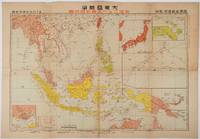
1719176771東京. Tokyo.: 日本放送出版会社. Nihon Hōsō Shuppan Kaisha. Showa 17 1942. Colour folding map scale 1:14500000 55cm x 80cm naval warship photographic illustrations on reverse. The wartime paper is browned and friable but small closed tears along fold lines and edges have been neatly repaired with archival washi on the verso. 79 x 53cm This colour map of Asia and the Pacific was published as a supplement to a magazine Hoso 放送 on January 1942 less than one month after the Pearl Harbor attack by the Japanese Forces. The war had just started but amazingly the map accurately predicted where the fighting would take place throughout the war. An inset map on upper right shows Singapore Borneo Sumatra and Java where battles took place in the area in early 1942. An inset chart on lower left shows various resources and their location including coal tin and iron ore clearly showing that the war was fought over securing resources. On reverse eleven photographic illustrations of war ships from Germany Britain the US and Japan are shown including the Prince of Wales and Enterprise. . 日本放送出版会社. [Nihon Hōsō Shuppan Kaisha]. unknown
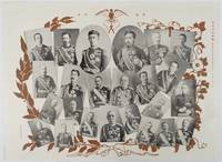
1906218805東京. Tokyo.: 東京日日新聞. Tokyo Nichinichi Shinbun. Meiji 39 1906. Black and white photographic illustrations 39.5 x 54.3cm light creasing where it has been folded very good. This collection of photographic portraits was published by Tokyo Nichinichi Newspaper on 1 January 1906 to commemorate the victory over Russia in the Russo-Japanese War. It features Meiji Emperor and his aristocratic members as well as major military commanders including Admiral Togo General Oyama and General Nogi. . 東京日日新聞. [Tokyo Nichinichi Shinbun]. unknown
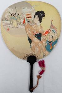
1921216196Japan. Taisho 10 1921. Colour printed paper fan print 23 x 24cm wooden handle 14.3 x 1.3cm with a colourful silk tassel. A little light wear visible on the reverse of the fan. A very good example. This fan depicts a celebratory scene: a woman in a kimono waves a scarf with a star design on it while in her other hand is a rising sun fan; her son clad in a sailor-style outfit holds a Navy flag. To the left behind them a victorious scene most likely from the Russo-Japanese War is depicted. On reverse there is text celebrating a long life of 95 years dated spring 1921. . unknown
1979169136江西.Jiangxi.: 中共江西省办公厅.Zhong gong Jiangxi ban gong ting. 1979. Three editorials from Xinhua News Agency dated between 2 March and 6 March 1979 were published during the Sino-Vietnamese War. The issues were re-printed and distributed by the General Office of Jiangxi Provincial Government shortly after the editorials were published. Issues no. 9 and 10: single sheet printed on both sides pages numbered. Issue no. 14: two sheets printed on both side pages numbered. Staples removed leaving small pin holes edges torn a 5.5cm horizontal closed tear on lower section of Issue 9. Even foxing and some soiling. Text in Chinese. 26.5 x 19cm when folded. An Original upper cover with small pin holes attached to Issue no.9 showing the editorials were gathered and distributed to a mechanical company in Jiujiang District by the General Office of the Jiangxi Provincial Government. . 中共江西省办公厅.[Zhong gong Jiangxi ban gong ting]. unknown
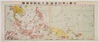
1719219230東京. Tokyo.: 日本放送協会. Nihon Hōsō Shuppan Kyōkai. Showa 17 1942. Colour folding map scale 1: 10000000 54.7cm x 79.5cm chronology of building the Greater East Asia Co-Prosperity Sphere on reverse. Some light browning a little darker at folds and reverse washi repairs to folds on reverse. This colour map of Asia and the Pacific published on 30 January 1942—just one month after Japan's attack on Pearl Harbor—offers a striking glimpse into wartime strategy and propaganda. Remarkably despite being produced at the war's outset it accurately anticipated key battlegrounds that would define the conflict. The main map is supplemented by two inset maps: one in the upper right highlighting Japan the Hawaiian Islands and Honolulu and another in the lower left focusing on Singapore with Darwin marked along the lower edge. <br> <br>The reverse side features a revealing chronological chart titled "Building Great East Asia" documenting Japan's military expansion from the 1931 Manchurian Incident through January 1942 as troops advanced across Southeast Asia. Notably two blank rows were intentionally left at the chart's end anticipating future victories to be recorded as the war progressed—a telling detail that underscores the map's dual role as both strategic document and propaganda tool. An interesting map which combines geographical precision with ideological messaging. . 日本放送協会. [Nihon Hōsō Shuppan Kyōkai]. unknown
1967169746Beijing.: 地图戰報.Di tu zhan bao. September1967. Maps printed in red and black single sheet printed on both sides folded scale not given photographic image of Mao Zedong. Some light browning at edges with tears and losses on left edge still good. Text in Chinese. Sheet measures 26.5 x 38.4cm. Includes a map of Autumn Harvest Uprising and also shows the routes of the military advancing towards Jinggangshan between September and October 1927. On reverse left section a map shows the route along which Chairman Mao led the Fourth Army of the Chinese Red Army marching towards south of Anhui and Jiangxi Provinces in 1929. On reverse right section a map titled "The Long March of The Chinese Workers' and Peasants' Red Army October 1934-October 1935". Quotations of Chairman Mao about the Long March insert on corners of the map. <br> <br>Issue no. 6 of a series of maps with text issued by the Red Guards organisations in the form of Cultural Revolution tabloid-sized newspaper. This issue is designed to celebrate the 40th anniversary of the Autumn Harvest Uprising which was one of the earliest armed uprisings organised by the Chinese Communist Party. . 地图戰報.[Di tu zhan bao]. unknown
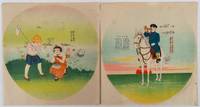
1940216176Japan. 1940. Two coloured fan prints 27.5 x 26cm. Occasional light marks a little light browning. Very good. These two propaganda prints were created to make children's paper fans each carrying patriotic messages and delicately rendered in bright colors.<br><br>The first sheet features a young boy on a white horse blowing a bugle. A Japanese warplane is seen flying in the sky with the rising sun in the background. The caption urges people not to disclose any military secrets even to close friends. Additionally the lyrics of the 1940 nationalistic song "Kokumin Shingunka" are printed on the sheet. <br><br>The second sheet depicts an idyllic scene of children playing by a lake catching dragonflies and fish. The boys are portrayed in more active roles while the girls hold a bucket or a cage. The message on this sheet reads "East Asia's Future is Bright and Children are Thriving." A warplane can be seen in the sky in the far distance subtly tying the peaceful scene to the wartime context. . unknown
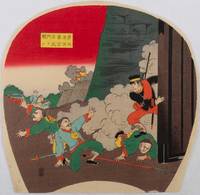
216197Japan. Early 20th Century. Colour woodblock fan print 24.5 x 25cm very good copy. This fan-shaped colour woodblock print features a 1894 battle scene from the Sino-Japanese War in Pyongyang. In order to break into the Chinese fortress a group of Japanese solders climbed over a wall opened the gate and led the Japanese troops in. Among the soldiers Harada Jukichi became well-known as one of the bravest returning home to hero's welcome after the war. However he was overwhelmed with numerous visitors which ended up forcing him into serious debt. In order to pay off this debt he travelled throughout Japan re-enacting the fighting and victorious scenes on stage. This print depicts courageous Harada single handed taking on his Chinese enemies who are falling or fleeing. . unknown
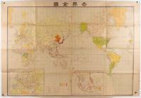
1942177779東京. Tokyo.: 盛文館. Seibunkan. Circa1942. Colour map 75 x 110cm folds to 28 x 19cm. Some light browning somewhat heavier along a few folds. A good copy. This map which was most likely published around 1942 or 1943 depicts the world during the global conflict. Japan is positioned in the centre and its territories are coloured in red. In Southeast Asia Japanese-occupied areas including Singapore the Philippines and the Dutch East Indies are marked with red. Two inset maps display Europe and the Japanese-occupied area to the south as the "Southern Co-Prosperity Sphere." The map is folded to 28 x 19 cm and its cover features the national flags of Japan Nazi Germany Italy the Soviet Union Britain and the United States arranged artistically. . 盛文館. [Seibunkan]. unknown