PtolemyBiblio.com

335 résultats
ria9781108063647_inpPaperback. New. New Book; Fast Shipping from UK; Not signed; Not First Edition; Published 1898–1907 this three-part collection edited by the Danish philologist Johan Ludvig Heiberg 1854–1928 contains the extant astronomical works in Greek of Ptolemy active in second-century Alexandria. Volume 1 appeared i paperback
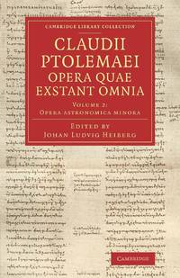
ria9781108063661_inpPaperback. New. New Book; Fast Shipping from UK; Not signed; Not First Edition; Published 1898–1907 this three-part collection edited by the Danish philologist Johan Ludvig Heiberg 1854–1928 contains the extant astronomical works in Greek of Ptolemy active in second-century Alexandria. Volume 2 1907 con paperback
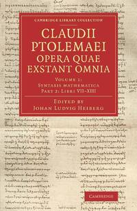
ria9781108063654_inpPaperback. New. New Book; Fast Shipping from UK; Not signed; Not First Edition; Published 1898–1907 this three-part collection edited by the Danish philologist Johan Ludvig Heiberg 1854–1928 contains the extant astronomical works in Greek of Ptolemy active in second-century Alexandria. Volume 1 appeared i paperback
338653662X.Gpaperback. Good. Access codes and supplements are not guaranteed with used items. May be an ex-library book. paperback
1391363671.Ghardcover. Good. Access codes and supplements are not guaranteed with used items. May be an ex-library book. hardcover
1390897001.Gpaperback. Good. Access codes and supplements are not guaranteed with used items. May be an ex-library book. paperback
46446226like new. unknown
1396316329.Ghardcover. Good. Access codes and supplements are not guaranteed with used items. May be an ex-library book. hardcover
B9781108063661Paperback / softback. New. Published 1898-1907 this three-part collection edited by the Danish philologist Johan Ludvig Heiberg 1854-1928 contains the extant astronomical works in Greek of Ptolemy active in second-century Alexandria. Volume 2 1907 contains Ptolemy's shorter astronomical works notably Hypotheseis ton planomenon his planetary hypotheses along with a substantial Latin prolegomena. paperback
B9781108063654Paperback / softback. New. Published 1898-1907 this three-part collection edited by the Danish philologist Johan Ludvig Heiberg 1854-1928 contains the extant astronomical works in Greek of Ptolemy active in second-century Alexandria. Volume 1 appeared in two parts. Part 2 1903 contains Books 7-13 of Ptolemy's major astronomical treatise the Almagest. paperback
B9781108063647Paperback / softback. New. Published 1898-1907 this three-part collection edited by the Danish philologist Johan Ludvig Heiberg 1854-1928 contains the extant astronomical works in Greek of Ptolemy active in second-century Alexandria. Volume 1 appeared in two parts. Part 1 1898 contains Books 1-6 of Ptolemy's major astronomical treatise the Almagest. paperback
1108063667.Gpaperback. Good. Access codes and supplements are not guaranteed with used items. May be an ex-library book. paperback
1108063659.Gpaperback. Good. Access codes and supplements are not guaranteed with used items. May be an ex-library book. paperback
1108063640.Gpaperback. Good. Access codes and supplements are not guaranteed with used items. May be an ex-library book. paperback
1016580363.Ghardcover. Good. Access codes and supplements are not guaranteed with used items. May be an ex-library book. hardcover
1016812361.Gpaperback. Good. Access codes and supplements are not guaranteed with used items. May be an ex-library book. paperback
8053615. PTOLEMY. GEOGRAPHIA UNIVERSALIS VETUS ET NOVA complectens<br /> Claudii Ptolemaei Alexandrini enarrationis libros VIII. Quorum<br /> primus noua translatione Pirckheimheri et accessione commentarioli<br /> illustrior quàm hactenus fuerit redditus est . Succedunt tabulae<br /> Ptolemaicae opera Sebastiani Munsteri nouo paratae modo. His<br /> adiectae sunt plurimae nouae tabulae. Basileae: apud Henricum<br /> Petrum 1540.<br /> <br /> 20 of 48 maps present: 5. Gallia 6. Germaniam Magnam 11. Iazyges<br /> Metanastas Daciam 17. Ionid Trapesus 18 Sarmatia Asiaticam 19.<br /> Colchidem Iberiam 22. Arabia Felix 23. Margianam Bactriana 25.<br /> Ariam Paropanisadas 26. Indiam Gangem Flu 29. Europa Prima 31.<br /> Hispanium 33. Helvetiae 34. Germania 35. Alsatia 36. Teria<br /> Rheni 37. Quartia Rheni 38. Brabantia et Geldria 39. Svevia et<br /> Bavaria 40. Franconia.<br /> <br /> All maps have descriptive letterpress printed within a decorative<br /> frame on reverse.<br /> Most maps have some worming at the center.<br /> Map 5 Gallia cannot be opened fully; at some point it was glued<br /> together along the center fold when a new backingstrip was laid<br /> down.<br /> <br /> Small folio: 2a4a-c6A-N6 - maps - 62A-2B32C8 30.3.cm. unknown
8053615. unknown books
026714864X.Ghardcover. Good. Access codes and supplements are not guaranteed with used items. May be an ex-library book. hardcover
45260156like new. unknown
B9781018753300Hardback. New. hardcover
1023827670.Ghardcover. Good. Access codes and supplements are not guaranteed with used items. May be an ex-library book. hardcover
1287729436.Gpaperback. Good. Access codes and supplements are not guaranteed with used items. May be an ex-library book. paperback
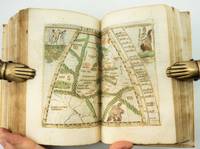
1548ST20876Venice: Giovanni Baptista Pedrezano 1548. First Complete Edition in Italian. Translated by Pietro Andrea Mattioli. Binding size: 175 x 116 mm. 6 7/8 x 4 5/8". ENTIRELY COMPLETE: binder's blank 816 pp. collating as dagger8 A-DD8 DD8 being blank 240 pp. as maps a-h8. <br/> Modern 19th century vellum over flexible boards three raised double bands new pastedowns and free endpapers. Woodcut initials throughout occasional diagrams one full-page decorative woodcut side-borders to title-page fine woodcut portrait of Ptolemy observing the heavens and 60 DOUBLE-PAGE COPPER-ENGRAVED MAPS BY GIACOMO GASTALDI ALL COLORED BY A CONTEMPORARY HAND the land masses enhanced with small depictions of ships mermaids sea monsters strange human figures wild and domestic animals including fish an elephant leopard and chicken and other charming embellishments Pedrezano's large woodcut device on colophon leaf 2D7r and verso of final leaf the maps with landmarks and place names each map guarded by a thin vellum strip taken from a 14th century manuscript executed in a fine scribal hand. Front flyleaf with the early signature of Lelio Capilupi presumably belonging to the book's first or at least early owner and very possibly being that of the Mantuan poet humanist and courtier Lelio Capilupi 1497-1560 known for his "Centones ex Virgilio." Adams P-2234; Alden & Landis 548/31; Burden North America 16 & 17; EDIT16 CNCE 47524; Harrisse BAV 285; JCB3 I:153; Mortimer Italian 404; Nordenskiold 2:214; Phillips Atlases 369; Sabin 66502; Shirley Mapping of the World 87 & 88; Streeter sale 1. Spine and part of the covers with some darkening apparently as an antiquing effect but the binding completely solid and entirely harmless. Intermittent faint dampstain at various places on the page though the vast majority of leaves unaffected map of British Isles with very small repaired hole caused by acidic paint only visible if you look for it bottom margin of three maps and one left margin of another neatly reinforced a handful of margins a bit smudged other trivial imperfections but an extremely attractive copy internally the paper remarkably strong and fresh and with virtually none of the signs of use so often seen with early atlases.<br/> <br/> Because of its innovative size its extensive use of copper engravings instead of woodcuts its introduction of nearly three dozen modern maps and especially its new images of the Americas this is a landmark cartographical publication--and the copy we offer is an extremely rare example of the work enriched with full contemporary hand coloring. It is the first complete printing in Italian following Berlinghieri’s verse paraphrase of 1482 of Ptolemy's universally recognized atlas of the classical world and much more important it is the first version of the work small enough to be practicably carried by hand or in a purse or pocket. In addition although a very small number of earlier atlases exist with copper engravings no previous one is engraved to the extent seen here with five dozen double-page maps presenting dramatically finer detail for example in more refined coastlines and more cleanly realized decorative elements than was possible with images cut from wood. As Nordenskiold notes our 1548 edition was a kind of rediscovery of the virtues of the intaglio cartographic image with no engraved atlas having been printed in the 16th century before ours. In terms of content of central importance here are first engraved maps of parts of North and South America providing legitimacy to Nordenskiold's characterization of our work as "the very first atlas of the New World." There are seven major America-related cartographical achievements in our Pedrezano edition five of them being the modern World map map 59; the other world map "Carta marina" which is the first sea chart depicting the modern world map 60; "Tierra nova" the first separate map of the South American Continent map 54; "Nueva Hispania" the earliest separate map of the Gulf Coast Mexico and the present American Southwest map 55; and "Tierra nueva" the earliest individual map of the east coast of North America from north Florida to Labrador map 56 showing the discoveries of Giovanni da Verrazzano and Jacques Cartier. These last three plus a map of Cuba and one of Hispaniola represent the earliest printed American regional maps. Beyond the American images the 1548 "Geografia" also includes an atypically exo-European eclecticism highlighted by what is apparently the first separate map of the Indian peninsula along with the first separate map devoted to Arabia and the first reference to Singapore on a printed map. The maps were the work of Giacomo Gastaldi ca. 1500 - 1566 Cosmographer to the Venetian Republic and the most prominent Italian cartographer of the period known especially for keeping up to date with the latest geographical discoveries and incorporating them into his maps. While 26 of the 60 maps are based on Ptolemy distinctive here and in other editions within their trapezoidal frames the greater number 34 are the modern work of Gastaldi. The book is consequently one of the very best examples of the integration of the period's Age of Discovery with the groundwork laid by Classical writers. Gastaldi was also responsible for updating and adding modern place names an enormous undertaking as is reflected in the 127-page index here. The history of world exploration owes an immeasurable debt to Claudio Tolomeo ca. 90 - ca. 168 AD who included in his "Geografia" what was known about the geography of the world during the Roman Empire of his lifetime and except for some excavated carved maps Ptolemy's are essentially all we have as a source for the world trodden by the ancients. Manuscripts of his work are known to date as early as ca. 1300 and there were multiple 15th century printings. But all incunabular editions were very large books volumes to be beheld rather than be held and used in any portable context. Waldseemuller's 1513 Strassburg edition was just as weighty. By contrast our edition offered its owner a much more practical format and yet because of its broadening world of 60 maps it was nevertheless the most comprehensive atlas--and the most important one--published between Waldseemuller's and the monumental Ortelius "Theatrum" of 1570. Copies of the 1548 Ptolemy appear on the market from time to time though they typically are beset with condition problems. What seems never to appear--at least so far as we've been able to ascertain--are copies of the book with contemporary coloring. Surely even with a small format atlas issued for functional purposes there must have been copies that were colored on occasion. The Morgan Library does own a copy--apparently once possessed by Marie de Medici--that is colored and it is possible that such copies silently reside in other admittedly sometimes very brief records of institutional holdings but we were unable to find any evidence of such. Likewise and perhaps more telling we were unable to find any copies with period color in auction records which certainly would have prominently announced such an important feature. The Streeter copy and the Wardington copy for example were uncolored. In sum this is a cartographic work of signal importance in especially attractive condition with no small amount of charm in its maps' various real and imagined inhabitants and offered in a colored state that seems virtually never to appear for sale. Giovanni Baptista Pedrezano unknown
GOR012736479Paperback. Very Good. paperback