PtolemyBiblio.com

335 résultats
1998SONG0691002606Princeton University Press 1998-10-19. Revised ed. paperback. Used: Good. 6.25x1.25x9.50. Buy with confidence. Excellent Customer Service & Return policy. Princeton University Press paperback
1998DADAX0691002606Princeton University Press 1998-10-19. Revised ed. paperback. New. 6.25x1.25x9.50. Buy with confidence. Excellent Customer Service & Return policy. Princeton University Press paperback
SONG0674994795Harvard University Press 1940-01-01. hardcover. Used: Good. 4.25x1.00x6.37. Buy with confidence. Excellent Customer Service & Return policy. Harvard University Press hardcover
DADAX0674994795Harvard University Press 1940-01-01. hardcover. New. 4.25x1.00x6.37. Buy with confidence. Excellent Customer Service & Return policy. Harvard University Press hardcover
033223066X.Ghardcover. Good. Access codes and supplements are not guaranteed with used items. May be an ex-library book. hardcover
0365971189.Gpaperback. Good. Access codes and supplements are not guaranteed with used items. May be an ex-library book. paperback
0674994795.Ghardcover. Good. Access codes and supplements are not guaranteed with used items. May be an ex-library book. hardcover
102483560X.Ghardcover. Good. Access codes and supplements are not guaranteed with used items. May be an ex-library book. hardcover
1277303584.Gpaperback. Good. Access codes and supplements are not guaranteed with used items. May be an ex-library book. paperback
2251470042.Gpaperback. Good. Access codes and supplements are not guaranteed with used items. May be an ex-library book. paperback
2014497656.Gpaperback. Good. Access codes and supplements are not guaranteed with used items. May be an ex-library book. paperback
2329075766.Gpaperback. Good. Access codes and supplements are not guaranteed with used items. May be an ex-library book. paperback
1020416408.Ghardcover. Good. Access codes and supplements are not guaranteed with used items. May be an ex-library book. hardcover
2013671539.Gpaperback. Good. Access codes and supplements are not guaranteed with used items. May be an ex-library book. paperback
62323Paris chez Cardin Besongne 1640 - reprint en fac-simile - Loge Astrologique de France 1985 In-12 xix-465pp. un des 300 exemplaires numérotés unknown
62444Venice 1596. FIRST EDITION THUS. Original engraved map of the Arabian Peninsula 16 x 21.5 cm. overall with Latin text to verso. Embellished with sea monster to lower right corner. An excellent copy. This early map engraving is from Claudius Ptolemaeus Ptolemy and Giovanni Antonio Magini's Geographiae universae tum veteris tum novae absolutissimum opus duobus voluminibus distinctum. The work was published in Venice by S. Galignani de Karera's Heirs in 1596. This is the first Magini edition. "The copperplate maps prepared for this edition and engraved by Girolamo Porro are on a smaller scale and somewhat better executed than those in the editions of 1562" Phillips. [Venice, 1596]. unknown
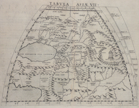
63967Venice 1596. Original engraved map of the Arabian Peninsula 12.5 x 17.5 cm on single leaf 29 x 20.5 cm with Italian text beneath. Verso printed with a map of Central Asia 'Tavola Settima Dell'Asia. Tabula Asiae VII' 12.5 x 17.5 cm. A very good example. This early map engraving is from Claudius Ptolemaeus Ptolemy and Giovanni Antonio Magini's Geographiae universae tum veteris tum novae absolutissimum opus duobus voluminibus distinctum. The work was published in Venice by S. Galignani de Karera's Heirs in 1596. This is the first Magini edition. "The copperplate maps prepared for this edition and engraved by Girolamo Porro are on a smaller scale and somewhat better executed than those in the editions of 1562" Phillips. [Venice, 1596]. unknown
156118808Venedig, Valgrisi, 1561. 3 Teile in 1 Bd. 4 nn. Bll., 358 S., 1 Bl.; 28 Bll., 47 S., 24 Bll. mit einigen Textholzschnitten. 64 doppelblattgroßen Kupferkarten (mit Rückentext). Gr.-8°. Pgmt. der Zeit mit hs. Rückentitel (Gebrssprn.). [5 Warenabbildungen]
[Anno MCCCCLXXXII augusti vero kalendas XVII impressum Ulme per ingeniosum virum Leonardum Hol. (Ulm, Lienhart Holle, 16 luglio 1482)]. Foglio del "Tolomeo di Ulm" (prima edizione, del 16 luglio) recante la carta geografica della penisola indocinese impressa in xilografia a doppia pagina su una facciata e il relativo testo descrittivo, stampato su una pagina dell'altra facciata. Il foglio misura mm. 401x523; l'immagine, misura, al filetto esterno della xilografia, mm. 380x300 (nel punto più corto in larghezza) e mm. 380x372 (nel punto più lungo in larghezza). Coloritura a mano originale. Sulla xilografia sono visibili delle ossidazioni dovute alla presenza al verso del foglio d'una cornice e d'una iniziale a stampa miniate con un colore verde che col tempo ha ossidato la carta. Nel 1482 Lienhart Holle pubblicò ad Hulm una edizione della Geografia di Tolomeo basata sulle carte di Nicolaus Germanus (c. 1420 - c. 1490) che aveva prodotto a Firenze una serie di magnifici atlanti manoscritti su pergamena negli anni 60 e 70 del Quattrocento. Il modello sul quale furono esemplate le carte di Hulm fu l'atlante manoscritto che Nicolaus aveva offerto al papa Paolo II e che pare fosse stato inviato appositamente in Germania (senza essere mai più rispedito a Roma: è conservato allo Schloss Wolfegg). L'edizione di Ulm è il primo atlante pubblicato a Nord delle Alpi e il primo con le carte impresse in xilografia (i due incunaboli precedenti della Geografia di Tolomeo - Bologna 1477 e Roma 1478 - recavano carte incise in rame). L'incisore delle xilografie fu probabilmente Johann Schnitzer di Armsheim (il planisfero reca la sua firma). Una delle mappe più ricercate della penisola indocinese, la terza in assoluto, in ordine di tempo, che sia stata impressa in un atlante a stampa. Per quanto riguarda il Tolomeo stampato ad Ulm cfr. Gof P1084; HC *13539; BMC II 538; IC.9309; Schreiber 5031; Sabin 66472; Nordenskiold Collection II, 199.Sheet of "Ptolemy of Ulm" (first edition, July the 16th, 1482) bearing the geographical map of the Indochinese peninsula printed in double-page woodcut on one side and the relative descriptive text, printed on one page of the other side. The sheet measures mm. 401x523; the image measures, to the external fillet of the woodcut, mm. 380x300 (at the shortest point in width) and mm. 380x372 (at the longest point in width). Original hand coloring. On the woodcut you can see some oxidations due to the presence on the back of the sheet of a frame and of an initial illuminated with a green color that over time has oxidized the paper. In 1482 Lienhart Holle published in Hulm an edition of Ptolemy's Geography based on the maps of Nicolaus Germanus (c. 1420 - c. 1490) who had produced in Florence a series of magnificent handwritten atlases on parchment in the 1460s and 1470s. The model on which Hulm's maps were patterned was the manuscript atlas that Nicolaus had offered to Pope Paul II and which seems to have been specially sent to Germany (without ever being sent back to Rome: it is kept at Schloss Wolfegg). The Ulm edition is the first atlas published north of the Alps and the first with the maps printed in woodcut (the two previous incunabula of Ptolemy's Geography - Bologna 1477 and Rome 1478 - had copper engraved maps). The engraver of the woodcuts was probably Johann Schnitzer of Armsheim (the planisphere bears his signature). One of the most sought after maps of the Indochinese peninsula, the third ever, in order of time, which has been imprinted in a printed atlas.
1901031228Paris: Editore Alfredo Firmin-Didot 1901. 1st Edition . Soft cover. Good. Ii Pp 571-1023. Original Printed Green Wrappers. 26.5 Cm Tall. Volume I Part 2 Only. Text In Greek And Latin Extensively Annotated In Latin. Wear With Minor Losses To Spine Edges Preliminary Pages Detached But Present. <br/> <br/> Editore Alfredo Firmin-Didot paperback
1561LBW02516[Venise, 1561]. 185 x 247 mm.
1561LBW0251d[Venise, 1561]. 183 x 246 mm.
182069190Paris, Merlin, 1820, , 3 parties en un volume, [6]-32-224-VIII-[3] pages, [2] ff. pour le titre pour les 2nde et 3e parties, 1 portrait, 2 pl. depl. gravées sur cuivre, 2 tableaux depl. ht, demi-basane maroquinée verte de l'époque, dos lisse orné de fers romantiques, tranches citron mouchetées, Plusieurs figures gravées dans le texte, dont une vignette au titre figurant le Qasr, deux vues du Mujelibè, des tablettes cunéiformes, un plan des ruines de Babylone, etc... Rare édition originale de la première traduction française de ces traités astronomiques de Ptolémée et de Proclus, donnée par le traducteur français de l'Almageste Nicolas Halma (1755-1828). Ce dernier signe deux dissertations figurant parmi les pièces liminaires : Dissertation III sur les Macédoniens et Dissertation IV sur le calendrier judaïque. La seconde partie de l'ouvrage contient les traités grecs, sur deux colonnes, le texte grec en regard de la traduction française ; et la troisième partie comprend les Mémoires traduits de l'allemand de Ludwig Ideler, sur les connaissances astronomiques des Chaldéens, sur le cycle de Méton et sur l'ère persique. Ouvrage dédicacé au duc de Bordeaux (Henri d'Artois, 1820-1883) ; en regard de la dédicace figure le portrait en médaillon de son père, le duc de Berry, assassiné peu de temps avant sa naissance, avec le vers tiré d'Horace "multis ille bonis flebilis occidit" apposé, à l'origine, sur les médailles frappées en 1793 en Angleterre en hommage à Louis XVI ("Il est tombé pleuré de beaucoup de gens de bien"). Selon Quérard, cet ouvrage, tout comme les diverses traductions de Ptolémée par Halma, aurait été tiré à 300 exemplaires, dont 200 auraient été pris par le gouvernement. De la bibliothèque Charles-René de Contamine, avec son ex-libris armorié au contreplat. Légères rousseurs éparses ; néanmoins, bel exemplaire. Quérard VII, p. 369 Couverture rigide
1552LBW01b4b[Bâle, 1552]. 268 x 333 mm.
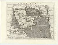
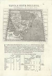
15617550Carte par Ptolémée. Produite sur cuivre pour la première fois par Ruscelli. Nomenclature latine "Tabula Asiae IIII". Descriptif au dos en italien.Venise, chez Valgrise 1561.Carte trapézoïdale sous chemise cartonnée, mais envoyée sans le support. Carte très primitive et rare. Très bon état. Format in-4° (25x19).