Philleo, Calvin WheelerBiblio.com

243 résultats
185553902New York: Dix & Edwards 1855. First edition; 8vo pp. 2 264 8 pages of advertisements 2; the advertisements include reviews for Putnam's Monthly Magazine and for the weekly literary journal Household Words edited by Charles Dickens; original blindstamped brown cloth with gilt decorations and lettering on the spine; near fine. Wright II 1888. Dix & Edwards unknown
183633913N Y: Harper & Brothers. Very Good with no dust jacket. 1836. New edition. Hardcover. 12mo 7" - 7½" tall; 5 359 pages; Written from an American view with comments on the union of Church and State. Publisher's green cloth rubbed an a bit rolled. Contents bright with occasional minor foxing binding crack held firmly by threads at the title page. . Harper & Brothers hardcover
1848153374Albany : Printed By Packard & Van Benthuysen 1848. Second edition revised and improved. Hardback. Fine copy re-bound in pebble cloth. Corners sharp with an overall tight bright and clean impression. Uncommon in such positive condition. ; 382 pages; Description: vii 382 p. ; 19 cm. Subjects: Shakers. Albany : Printed By Packard & Van Benthuysen hardcover
1854012979Edinburgh: Johnstone and Hunter 1854. Book measures 19x12.5.cm. x 293pp ivpp catalogue engraved frontis. Bound in original publishers embossed cloth with gilt title lettering full gilt edges coloured endpapers. Cloth lightly rubbed marked age darkened private library number on spine. Binding in good condition. Internally private library stamp on free endpaper. Pages in good clean condition. A nice copy. . Cloth. Near Very Good. 8vo. Johnstone and Hunter Hardcover
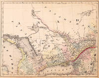
184520539Cassel: Th. Fischer 1845. Other. In very good to excellent condition. A few small marginal mended tears at the blank bottom not affecting the image of the map and a few minor marginal pin holes. 373 by 479mm 14 by 18 inches. Lithograph original color in outline by Smith J. Calvin published 1845 by Th. Fischer Cassel. Image size: 373 by 479mm 14 by 18 inches. From Smith's multi-sheet Special-Karte one of the most detailed and accurate mid-19th-century maps of the United States. John Calvin J. Calvin Smith c.18091890 was an American surveyor geographer and engraver active in New York City from the 1840s. Working with partners including George Sherman under the Sherman & Smith imprint 18401853 and later in association with J.H. Colton Smith produced some of the most accurate and widely used general-purpose maps of the United States of his era. His maps appeared in government publications military surveys and commercial atlases and his multi-sheet Special-Karte der Vereinigten Staaten published in a German-language edition brought American cartographic standards to European audiences. Despite his prolific output and importance to American cartographic history much of Smith's personal biography remains obscure.This decorative map shows the region from West Canada Ottawa River towards East Canada. Detailed information on the map on Lake Ontario the Georgian Bay Nipissing Lake Temiscaming Lake and the Ottawa River. Inside the map are many place names rivers lakes etc. engraved. As well names on Indian tribes are given. In very good to excellent condition. A few small marginal mended tears at the blank bottom not affecting the image of the map and a few minor marginal pin holes. Th. Fischer unknown
1861765741861. WILEY Calvin Henderson et al. Address to the People of North Carolina. Raleigh: n.p. 1861. 1st ed. 15pp. Old waterstain to top half light scattered foxing else very good. Address given at a conference of teachers and other friends of education held in Raleigh." P&W 7965. unknown
1837056827London & Leicester: Hamilton Adams - London & Combe & Co Leicester 1837. Second Edition . Hardcover. Very Good Plus. 8vo. LEICESTER: 1837. Second printing; first printed 1587. Reprinted by Combe and Co in Leicester 1837. First published: at Edinburgh The imprint is false; in fact printed in London at Eliot's Court Press see STC.: 1587. Abridgment and translation of Institutio Christianae Religionis. . Hardback. Contemporary full black Morocco-leather; gilt lettered spine. Gilt lettered spine and gilt ruled raised bands. All edges gilt. Armorial bookplate of Graham Hewett R.A. No internal markings. Tight bright and clean. Minor wear only. VERY GOOD INDEED. xv 332 pages. Previous edition 1587. 8vo. Will be well-packed for posting/shipping. Rosley Books for Antiquarian books CHS Cumberland Everyman GKC Inklings Keswick Literature MacDonald Rarities Theology and History. SCARCE. <br/> <br/> Hamilton, Adams - London & Combe & Co Leicester hardcover
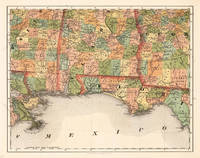
185524693Kassel: Theodor Fischer 1855-60. Other. In excellent condition. 370 by 470mm 14 by 18 inches. 370 by 470mm 14 by 18 inches. Lithograph original color in outline by Smith J. Calvin published 1855-60 by Theodor Fischer Kassel. Image size: 370 by 470mm 14 by 18 inches. From Smith's multi-sheet Special-Karte one of the most detailed and accurate mid-19th-century maps of the United States. John Calvin J. Calvin Smith c.18091890 was an American surveyor geographer and engraver active in New York City from the 1840s. Working with partners including George Sherman under the Sherman & Smith imprint 18401853 and later in association with J.H. Colton Smith produced some of the most accurate and widely used general-purpose maps of the United States of his era. His maps appeared in government publications military surveys and commercial atlases and his multi-sheet Special-Karte der Vereinigten Staaten published in a German-language edition brought American cartographic standards to European audiences. Despite his prolific output and importance to American cartographic history much of Smith's personal biography remains obscure.This antique map of Alabama Florida No: 14 was published in 1855-60 by Theodor Fischer Kassel 370 by 470mm 14 by 18 inches. It is printed as a lithograph original color in outline. The map documents the region with careful attention to rivers settlements roads and political boundaries reflecting the geographical knowledge available at the time of publication and offering an invaluable primary source for historians and collectors of North American antique cartography. In excellent condition. Theodor Fischer unknown
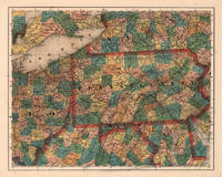
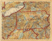
185524687Kassel: Theodor Fischer 1855-60. Other. In excellent condition. 374 by 470mm 14 by 18 inches. 374 by 470mm 14 by 18 inches. Lithograph original color in outline by Smith J. Calvin published 1855-60 by Theodor Fischer Kassel. Image size: 374 by 470mm 14 by 18 inches. From Smith's multi-sheet Special-Karte one of the most detailed and accurate mid-19th-century maps of the United States. John Calvin J. Calvin Smith c.18091890 was an American surveyor geographer and engraver active in New York City from the 1840s. Working with partners including George Sherman under the Sherman & Smith imprint 18401853 and later in association with J.H. Colton Smith produced some of the most accurate and widely used general-purpose maps of the United States of his era. His maps appeared in government publications military surveys and commercial atlases and his multi-sheet Special-Karte der Vereinigten Staaten published in a German-language edition brought American cartographic standards to European audiences. Despite his prolific output and importance to American cartographic history much of Smith's personal biography remains obscure.This antique map of Pennsylvania No:7 was published in 1855-60 by Theodor Fischer Kassel 374 by 470mm 14 by 18 inches. It is printed as a lithograph original color in outline. The map documents the region with careful attention to rivers settlements roads and political boundaries reflecting the geographical knowledge available at the time of publication and offering an invaluable primary source for historians and collectors of North American antique cartography. In excellent condition. Theodor Fischer unknown
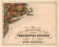
185524688Kassel: Theodor Fischer 1855-60. Other. In excellent condition. 375 by 473mm 14 by 18 inches. 375 by 473mm 14 by 18 inches. Lithograph original color in outline by Smith J. Calvin published 1855-60 by Theodor Fischer Kassel. Image size: 375 by 473mm 14 by 18 inches. From Smith's multi-sheet Special-Karte one of the most detailed and accurate mid-19th-century maps of the United States. John Calvin J. Calvin Smith c.18091890 was an American surveyor geographer and engraver active in New York City from the 1840s. Working with partners including George Sherman under the Sherman & Smith imprint 18401853 and later in association with J.H. Colton Smith produced some of the most accurate and widely used general-purpose maps of the United States of his era. His maps appeared in government publications military surveys and commercial atlases and his multi-sheet Special-Karte der Vereinigten Staaten published in a German-language edition brought American cartographic standards to European audiences. Despite his prolific output and importance to American cartographic history much of Smith's personal biography remains obscure.This antique map of Special-Karte der Vereinigten Staaten von Nord-Amerika No: 8 was published in 1855-60 by Theodor Fischer Kassel 375 by 473mm 14 by 18 inches. It is printed as a lithograph original color in outline. The map documents the region with careful attention to rivers settlements roads and political boundaries reflecting the geographical knowledge available at the time of publication and offering an invaluable primary source for historians and collectors of North American antique cartography. In excellent condition. Theodor Fischer unknown
18489627np 1848. 16pp disbound and stitched minor scattered spotting. Very Good. <br /> <br /> NUC attributes authorship to Adams identified here only as "a Whig of the Free States." He is appalled at his Party's impending nomination of Zachary Taylor for the presidency. Taylor a Louisiana slaveholder had never voted or participated in civil affairs. His military career most recently in the Mexican War which northern Whigs had generally opposed as an unconstitutional land-grab for slavery was his only public activity. <br /> "He is a Military Chieftain-- and he is a Slave owner and in favor of the Extension of Slavery over new territories." Webster deserves the nomination: "Let there be no wavering none of the contemptible expediency doctrine which leads men to declare in one breath that Mr. Webster is their first choice and to say the next moment that they are ready to vote for General Taylor." <br /> FIRST EDITION. Sabin 55816. 3 NUC 0062491. Not in Miles LCP Eberstadt Decker Dumond. unknown
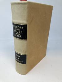
186886215Hartford Connecticut: Hartford Publishing Company 1868. Leather-bound. Very Good. Quarto. Recent re-binding in plush deerskin with contrasting black labels lettered in gilt affixed to spine. Marbled endpapers. New front free endpapers. Sunning to spine. A very few light smudges and tiny blems to deerskin - hardly noticeable. Stowe's thesis is that "the chain of documentary evidence has been broken. The author writes in the preface: ".Each one of the books of the New Testament must be traced up to the Apostles who only had authority to deliver inspired books to the churches. This is what the present volume professes to do. It is a book of authorities and testimonies; it is the tracing and verifying of title deeds." "But there are some deeds in which the chain is broken before we get to the original proprietors; there are some which are forgeries and others which were given by the persons whose names they bear but these persons had no authority to make the sales. All such deeds are invalid and confer no title." "These latter deeds represent the apocryphal books. It is proposed to show that every one of the apocryphal books belongs to one of these three classes to wit: 1. They can not be traced to the apostles; 2. Some of them are proved to be forgeries; 3. And others though genuine were written by persons who had no apostolic authority to give them to the churches." <br /> <br /> Stowe was married to Harriet Beecher Stowe and while the two were part of a group which provided shelter to northward-bound freedom seekers aka escaped slaves or free Blacks "<br /> <br /> ".As references in William Lloyd Garrison's radical abolitionist paper The Liberator document although Stowe privately decried slavery he was no abolitionist. He believed slavery was sanctioned by the Bible and that through Christian education slavery would gradually fade away. He was instead an advocate of colonization of free Blacks in Liberia as a "solution" to slavery. It was only after his wife Harriet Beecher Stowe's Uncle Tom's Cabin was published in 1852 that Stowe began haltingly to change his stance regarding slavery first as a signatory to a petition of New England clergy in opposition to the Kansas-Nebraska Act issued in 1854.Wikipedia. Hartford Publishing Company unknown
185216578Raleigh: Office of the 'Weekly Post.' 1852. 12mo. Contemporary full leather rebacked with original red leather spine label laid down. New endpapers. pp 199 1 blank xi 1 blank 4 publ. advts. Spotted endpapers else scattered spotting and foxing. Numerical accession rubberstamp in bottom margin of A2. About Good. <br /> <br /> Not a form book for lawyers the author explains but rather "a complete list of Forms of the various Instruments which the people themselves should know how to write and which in the course of their business they are constantly making." <br /> FIRST EDITION. Thornton 14855. BEAL 8091. 663 NUC 0305423 4. Not in Sabin Marke Harv. Law Cat. Office of the 'Weekly Post.' unknown
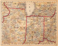
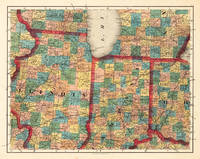
184520544Cassel: Th. Fischer 1845. Other. In very good to excellent condition. A few small marginal mended tears at the blank bottom not affecting the image of the map and a few minor marginal pin holes. 373 by 479mm 14 by 18 inches. 373 by 479mm 14 by 18 inches. Lithograph original color in outline by Smith J. Calvin published 1845 by Th. Fischer Cassel. Image size: 373 by 479mm 14 by 18 inches. From Smith's multi-sheet Special-Karte one of the most detailed and accurate mid-19th-century maps of the United States. John Calvin J. Calvin Smith c.18091890 was an American surveyor geographer and engraver active in New York City from the 1840s. Working with partners including George Sherman under the Sherman & Smith imprint 18401853 and later in association with J.H. Colton Smith produced some of the most accurate and widely used general-purpose maps of the United States of his era. His maps appeared in government publications military surveys and commercial atlases and his multi-sheet Special-Karte der Vereinigten Staaten published in a German-language edition brought American cartographic standards to European audiences. Despite his prolific output and importance to American cartographic history much of Smith's personal biography remains obscure.This decorative map shows Illinois Indiana and a part of Ohio. Further the southern part of Lake Michigan is shown. Inside the map are many place names rivers lakes etc. engraved. The various counties are colored in wash and explicitly detailed named. In very good to excellent condition. A few small marginal mended tears at the blank bottom not affecting the image of the map and a few minor marginal pin holes. Th. Fischer unknown
184519691Cassel: Th. Fischer 1845. Other. In very good condition. A few small marginal mended tears at the blank bottom verso old backed not affecting the image of the map and a few minor marginal pin holes. 373 by 476mm 14 by 18 inches. 373 by 476mm 14 by 18 inches. Lithograph hand-colored in outline by Smith J. Calvin published 1845 by Th. Fischer Cassel. Image size: 373 by 476mm 14 by 18 inches. From Smith's multi-sheet Special-Karte one of the most detailed and accurate mid-19th-century maps of the United States. John Calvin J. Calvin Smith c.18091890 was an American surveyor geographer and engraver active in New York City from the 1840s. Working with partners including George Sherman under the Sherman & Smith imprint 18401853 and later in association with J.H. Colton Smith produced some of the most accurate and widely used general-purpose maps of the United States of his era. His maps appeared in government publications military surveys and commercial atlases and his multi-sheet Special-Karte der Vereinigten Staaten published in a German-language edition brought American cartographic standards to European audiences. Despite his prolific output and importance to American cartographic history much of Smith's personal biography remains obscure.This antique map shows prominent in its centre the state of Pennsylvania with its neighboring states New York Ohio Delaware Maryland and Virginia. Inside the map are many place names rivers lakes mountains railroads etc. Many counties are named and finely hand colored in wash. A detailed map of this part of the Eastern United States by the famous 19th century mapmaker and cartographer Calvin Smith. In very good condition. A few small marginal mended tears at the blank bottom verso old backed not affecting the image of the map and a few minor marginal pin holes. Th. Fischer unknown
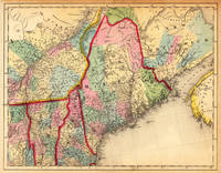
184514251Cassel: Th. Fischer 1845. Other. In very good condition. A few small marginal mended tears at the blank margins verso old backed not affecting the image of the map. 370 by 475mm 14 by 18 inches. 370 by 475mm 14 by 18 inches. Lithograph hand-colored in outline by Smith J. Calvin published 1845 by Th. Fischer Cassel. Image size: 370 by 475mm 14 by 18 inches. From Smith's multi-sheet Special-Karte one of the most detailed and accurate mid-19th-century maps of the United States. John Calvin J. Calvin Smith c.18091890 was an American surveyor geographer and engraver active in New York City from the 1840s. Working with partners including George Sherman under the Sherman & Smith imprint 18401853 and later in association with J.H. Colton Smith produced some of the most accurate and widely used general-purpose maps of the United States of his era. His maps appeared in government publications military surveys and commercial atlases and his multi-sheet Special-Karte der Vereinigten Staaten published in a German-language edition brought American cartographic standards to European audiences. Despite his prolific output and importance to American cartographic history much of Smith's personal biography remains obscure.This antique map shows prominent in its centre the state of Maine with its neighboring states Vermont New Hampshire and New Brunswick. The map extends from Salisbury in the south towards New Brunswick and the neighboring Nova Scotia. Inside the map are many place names rivers lakes mountains railroads etc. Many counties are named and finely hand colored in wash. A detailed map of this part of the Northeastern United States by the famous 19th century mapmaker and cartographer Calvin Smith. In very good condition. A few small marginal mended tears at the blank margins verso old backed not affecting the image of the map. Th. Fischer unknown
184747667New York: Harper & Brothers 1847. First Edition. Original wraps. Good. 152p octavo a good copy in fragile and very chipped printed publisher's wraps. Ex library with all the usual markings. Front wrapper just holding on. Author was from N Carolina. Scarce <br/><br/> Harper & Brothers paperback
1833001855London: Frederic Nestley and A. H. Davis 1833. Contemporary three-quarter calf marble boards. Spine top repaired; spine and corners rubbed; ownership notation on second blank leaf. xii 389pp 2 pp of ads "Imporatant Works Published by Westley and Davis". Very Good. Frederic Nestley and A. H. Davis hardcover
185524685Kassel: Theodor Fischer 1855-60. Other. In excellent condition. 370 by 470mm 14 by 18 inches. 370 by 470mm 14 by 18 inches. Lithograph original color in outline by Smith J. Calvin published 1855-60 by Theodor Fischer Kassel. Image size: 370 by 470mm 14 by 18 inches. From Smith's multi-sheet Special-Karte one of the most detailed and accurate mid-19th-century maps of the United States. John Calvin J. Calvin Smith c.18091890 was an American surveyor geographer and engraver active in New York City from the 1840s. Working with partners including George Sherman under the Sherman & Smith imprint 18401853 and later in association with J.H. Colton Smith produced some of the most accurate and widely used general-purpose maps of the United States of his era. His maps appeared in government publications military surveys and commercial atlases and his multi-sheet Special-Karte der Vereinigten Staaten published in a German-language edition brought American cartographic standards to European audiences. Despite his prolific output and importance to American cartographic history much of Smith's personal biography remains obscure.This antique map of Illinois Indiana No: 6 was published in 1855-60 by Theodor Fischer Kassel 370 by 470mm 14 by 18 inches. It is printed as a lithograph original color in outline. The map documents the region with careful attention to rivers settlements roads and political boundaries reflecting the geographical knowledge available at the time of publication and offering an invaluable primary source for historians and collectors of North American antique cartography. In excellent condition. Theodor Fischer unknown