ORTELIUS, AbrahamBiblio.com

213 résultats
159553045Antwerp. c.1595. Splendid map of the Artois region of north eastern France from Calais to Cambrai. Magnificent strapwork title cartouche at upper right scale with strapwork decorations at lower left. The dedicatory cartouche at left identifies this plate as van den Broecke 74. Published in the famous Theatrum Orbis Terrarum by the master Flemish cartographer Abraham Ortelius. Copper engraving. Fine condition good margins. Later colour. Size: 48 x 36.5 cm. Van den BroeckeOrtelius Atlas Maps 74. unknown
15957611Antwerp 1595. Copper engraving 35.5 x 48.5 cms recent-hand-colour Latin text on verso. First published in a 1592 edition of the Theatrum replacing the earlier Austriae Ducatus plate; Wolfgang Lazius is credited as the source. Van den Broecke 106 Map unknown
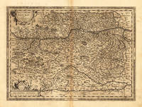
159817608Antwerp: Platin 1598. Other. In excellent condition. 356 by 486mm 14 by 19 inches. Original antique copper engraving published 1598 in a French text edition of the " Theatrum Orbis Terrarum. Uncolored example in a strong impression as published. This is the second plate of the Austria map after Wolfgang Lazius published for the first time in the "Theatrum Orbis Terrarum" after 1595. Here present in the 1598 edition. A highly decorative early map of the duchy of Austria towns are still shown as miniature engraved city views mountains woods rivers and lakes are decorative engraved. In the lower right corner a milage scale with a coat of arms. In the center of the map we find Vienna. The map reaches in the west from Linz towards the Neusiedler lake in the east. In the south with the neighbouring Carintia and Salzburg. Ortelius was born on 14 April 1527 in the city of Antwerp which was then in the Habsburg Netherlands modern-day Belgium. The Orthellius family were originally from Augsburg a Free imperial city of the Holy Roman Empire. In 1535 the family had fallen under suspicion of Protestantism. Following the death of Ortelius's father his uncle Jacobus van Meteren returned from religious exile in England to take care of Ortelius. Abraham remained close to his cousin Emanuel van Meteren who would later moved to London. In 1575 he was appointed geographer to the king of Spain Philip II on the recommendation of Arias Montanus who vouched for his orthodoxy. He travelled extensively in Europe and is specifically known to have traveled throughout the Seventeen Provinces; in southern western northern and eastern Germany e.g. 1560 15751576; France 15591560; England and Ireland 1576; and Italy 1578 and perhaps twice or thrice between 1550 and 1558. Beginning as a map-engraver in 1547 he entered the Antwerp Guild of Saint Luke as an illuminator of maps. He supplemented his income trading in books prints and maps and his journeys included yearly visits to the Frankfurt book and print fair where he met Gerardus Mercator in 1554. In 1560 however when travelling with Mercator to Trier Lorraine and Poitiers he seems to have been attracted largely by Mercator's influence towards the career of a scientific geographer. Wikipedia Broe. 106 Platin unknown
152353327Venice: Daniel Bamberg 1523. Daniel Bamberg unknown
159040297N.p. 1590. Image area 19-1/2" x 12-7/8" in 28" x 23" mat. 1 vols. Imperfectly colored along crease down center small and unobtrusive dampstain in one corner. Still a nice piece. Image area 19-1/2" x 12-7/8" in 28" x 23" mat. 1 vols. Abraham Ortelius 1527-98 was a Flemish geographer of German origin. His major work Theatrum Orbis Terrarum 1570 with later revisions and addendums was the first modern atlas. It was based on contemporary charts and maps and contained a collection of plates engraved by Frans Hagenberg in a uniform size and format. The Theatrum preceded the first atlas of Ortelius' good friend Gerardus Mercator. In fact popular sentimental legend has it that Mercator delayed publication of his own work so that his younger friend's would appear first. Although this simply isn't true Mercator wasn't ready the legendary cartographer did complement Ortelius for the "care and elegance" he had put into the Theatrum. unknown
159040297N.p. 1590. Image area 19-1/2" x 12-7/8" in 28" x 23" mat. 1 vols. Imperfectly colored along crease down center small and unobtrusive dampstain in one corner. Still a nice piece. Image area 19-1/2" x 12-7/8" in 28" x 23" mat. 1 vols. Abraham Ortelius 1527-98 was a Flemish geographer of German origin. His major work Theatrum Orbis Terrarum 1570 with later revisions and addendums was the first modern atlas. It was based on contemporary charts and maps and contained a collection of plates engraved by Frans Hagenberg in a uniform size and format. The Theatrum preceded the first atlas of Ortelius' good friend Gerardus Mercator. In fact popular sentimental legend has it that Mercator delayed publication of his own work so that his younger friend's would appear first. Although this simply isn't true Mercator wasn't ready the legendary cartographer did complement Ortelius for the "care and elegance" he had put into the Theatrum. unknown books
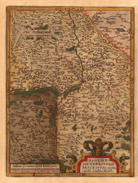
159821963Antwerp: Christopher Platin 1598. Other. A strong impression in excellent condition. 324 by 245mm 12 by 9 inches. Original copper engraving published 1598 in the famous atlas 'Theatrum Orbis Terrarum'. In French text edition. Detailed map of the Basel territory with renaissance title cartouche and scale bars. Villages and towns are shown as miniature views. Ortelius was born on 14 April 1527 in the city of Antwerp which was then in the Habsburg Netherlands modern-day Belgium. The Orthellius family were originally from Augsburg a Free imperial city of the Holy Roman Empire. In 1535 the family had fallen under suspicion of Protestantism. Following the death of Ortelius's father his uncle Jacobus van Meteren returned from religious exile in England to take care of Ortelius. Abraham remained close to his cousin Emanuel van Meteren who would later moved to London. In 1575 he was appointed geographer to the king of Spain Philip II on the recommendation of Arias Montanus who vouched for his orthodoxy. He travelled extensively in Europe and is specifically known to have traveled throughout the Seventeen Provinces; in southern western northern and eastern Germany e.g. 1560 15751576; France 15591560; England and Ireland 1576; and Italy 1578 and perhaps twice or thrice between 1550 and 1558. Beginning as a map-engraver in 1547 he entered the Antwerp Guild of Saint Luke as an illuminator of maps. He supplemented his income trading in books prints and maps and his journeys included yearly visits to the Frankfurt book and print fair where he met Gerardus Mercator in 1554. In 1560 however when travelling with Mercator to Trier Lorraine and Poitiers he seems to have been attracted largely by Mercator's influence towards the career of a scientific geographer. Wikipedia Broe: 114a Christopher Platin unknown
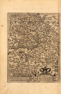
158426177Antwerp: Diesth 1584. Other. Old colored example. In excellent condition. 325 by 277mm 12 by 11 inches. Original copper engraving published 1584 in an early Latin text edition of the 'Theatrum Orbis Terrarum'. Oldcolored example in outline and wash color. Detailed map of the Basel territory with renaissance title cartouche and scale bars. Villages and towns are shown as miniature views. Ortelius was born on 14 April 1527 in the city of Antwerp which was then in the Habsburg Netherlands modern-day Belgium. The Orthellius family were originally from Augsburg a Free imperial city of the Holy Roman Empire. In 1535 the family had fallen under suspicion of Protestantism. Following the death of Ortelius's father his uncle Jacobus van Meteren returned from religious exile in England to take care of Ortelius. Abraham remained close to his cousin Emanuel van Meteren who would later moved to London. In 1575 he was appointed geographer to the king of Spain Philip II on the recommendation of Arias Montanus who vouched for his orthodoxy. He travelled extensively in Europe and is specifically known to have traveled throughout the Seventeen Provinces; in southern western northern and eastern Germany e.g. 1560 15751576; France 15591560; England and Ireland 1576; and Italy 1578 and perhaps twice or thrice between 1550 and 1558. Beginning as a map-engraver in 1547 he entered the Antwerp Guild of Saint Luke as an illuminator of maps. He supplemented his income trading in books prints and maps and his journeys included yearly visits to the Frankfurt book and print fair where he met Gerardus Mercator in 1554. In 1560 however when travelling with Mercator to Trier Lorraine and Poitiers he seems to have been attracted largely by Mercator's influence towards the career of a scientific geographer. Wikipedia Broe. 113 Diesth unknown
15957610Antwerp 1595. Copper engraving 38.5 x 49.5 cms recent-hand-colour Latin text on verso. First published in a 1573 edition of the Theatrum Philip Appian is credited as the source; Van den Broecke notes minor ornamental changes horizontal cross hatching which indicate that our map was printed from the plate in its third state. Map unknown
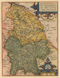
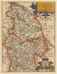
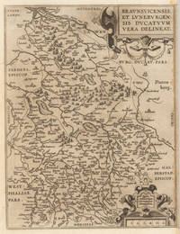
159535925Antwerpen: Platin 1595. In excellent condition. 31 x 235 cm 12.25 x 925 inches. Hand-Colored Original Copperplate Engraving by Abraham Ortelius depicting Braunsvicensis et Luneburgensis Ducatuum Vera Delineat. Published Antwerpen Platin 1595. Sheet: 31 x 235 cm 12.25 x 925 inches. A fine and original hand-colored example of Ortelius's celebrated cartographic work documenting this region of Germany with the precision and decorative artistry characteristic of the 15900s. Abraham Ortelius 1527-1598 was a Flemish cartographer and geographer from Antwerp widely regarded as the creator of the first modern atlas. His landmark publication Theatrum Orbis Terrarum 1570 set the standard for atlas-making for the next century presenting uniform copper-engraved maps with scholarly commentary. By Ortelius's death the Theatrum had appeared in 25 editions in seven languages. In 1575 King Philip II of Spain appointed him Royal Geographer. His maps engraved with extraordinary precision are among the most sought-after in antique cartography held in collections including the Plantin-Moretus Museum in Antwerp the Library of Congress and the British Library.This original copperplate engraving with original hand coloring depicts the region of Braunsvicensis et Luneburgensis Ducatuum Vera Delineat. published in Antwerpen Platin 1595. The map features a decorative Baroque cartouche containing the title inscription. A distance scale is incorporated within the cartouche or alongside it. The map records the political and geographic boundaries of the region as understood in 1595 offering a fascinating window into the history of German territorial organization. Sheet measures 31 x 235 cm 12.25 x 925 inches. In good condition overall with minor signs of age appropriate for a 16th-century engraving. Ready to frame. Broe. 99 Latin text Koeman Ort 28 & 29. Platin unknown
159535923Antwerpen: Platin 1595. In excellent condition. 31 x 235 cm 12.25 x 925 inches. Hand-Colored Original Copperplate Engraving by Abraham Ortelius depicting Braunsvicensis et Luneburgensis Ducatuum Vera Delineat. Published Antwerpen Platin 1595. Sheet: 31 x 235 cm 12.25 x 925 inches. A fine and original hand-colored example of Ortelius's celebrated cartographic work documenting this region of Germany with the precision and decorative artistry characteristic of the 15900s. Abraham Ortelius 1527-1598 was a Flemish cartographer and geographer from Antwerp widely regarded as the creator of the first modern atlas. His landmark publication Theatrum Orbis Terrarum 1570 set the standard for atlas-making for the next century presenting uniform copper-engraved maps with scholarly commentary. By Ortelius's death the Theatrum had appeared in 25 editions in seven languages. In 1575 King Philip II of Spain appointed him Royal Geographer. His maps engraved with extraordinary precision are among the most sought-after in antique cartography held in collections including the Plantin-Moretus Museum in Antwerp the Library of Congress and the British Library.This original copperplate engraving with original hand coloring depicts the region of Braunsvicensis et Luneburgensis Ducatuum Vera Delineat. published in Antwerpen Platin 1595. The map features a decorative Baroque cartouche containing the title inscription. A distance scale is incorporated within the cartouche or alongside it. The map records the political and geographic boundaries of the region as understood in 1595 offering a fascinating window into the history of German territorial organization. Sheet measures 31 x 235 cm 12.25 x 925 inches. In good condition overall with minor signs of age appropriate for a 16th-century engraving. Ready to frame. Broe. 99 Latin text Koeman Ort 28 & 29. Platin unknown
159835926Antwerpen: Platin 1598. In very good condition. 31 x 235 cm 12.25 x 925 inches. Hand-Colored Original Copperplate Engraving by Abraham Ortelius depicting Braunsvicensis et Luneburgensis Ducatuum Vera Delineat. Published Antwerpen Platin 1598. Sheet: 31 x 235 cm 12.25 x 925 inches. A fine and original hand-colored example of Ortelius's celebrated cartographic work documenting this region of Germany with the precision and decorative artistry characteristic of the 15900s. Abraham Ortelius 1527-1598 was a Flemish cartographer and geographer from Antwerp widely regarded as the creator of the first modern atlas. His landmark publication Theatrum Orbis Terrarum 1570 set the standard for atlas-making for the next century presenting uniform copper-engraved maps with scholarly commentary. By Ortelius's death the Theatrum had appeared in 25 editions in seven languages. In 1575 King Philip II of Spain appointed him Royal Geographer. His maps engraved with extraordinary precision are among the most sought-after in antique cartography held in collections including the Plantin-Moretus Museum in Antwerp the Library of Congress and the British Library.This original copperplate engraving with original hand coloring depicts the region of Braunsvicensis et Luneburgensis Ducatuum Vera Delineat. published in Antwerpen Platin 1598. The map features a decorative Baroque cartouche containing the title inscription. A distance scale is incorporated within the cartouche or alongside it. The map records the political and geographic boundaries of the region as understood in 1598 offering a fascinating window into the history of German territorial organization. Sheet measures 31 x 235 cm 12.25 x 925 inches. In good condition overall with minor signs of age appropriate for a 16th-century engraving. Ready to frame. Broe. 99 French text; Koeman Ort 31; Platin unknown
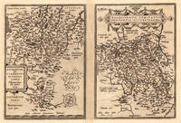
15958222Antwerp Plantin-Moretus 1595. Copper engraving 31 x 47.5 cms modern hand-colour Latin text on verso. Two maps on one sheet the Duchy of Brunswick-Lüneburg and the environs of Nuremberg.Van den Broecke 99a.1/99b.2 Map unknown
157430110Antwerpen: Platin 1574. Other. In very good to exellent condition. 310 by 220mm 12 by 8 inches. Hand-Colored Original Copperplate Engraving by Abraham Ortelius depicting Buchauiae siue Fuldensis Ditonis Tyous. Wolfgango Regr: will auc tore. 1574. Published Antwerpen Platin 1574. Sheet: 310 by 220mm 12 by 8 inches. A fine and original hand-colored example of Ortelius's celebrated cartographic work documenting this region of Germany with the precision and decorative artistry characteristic of the 15700s. Abraham Ortelius 1527-1598 was a Flemish cartographer and geographer from Antwerp widely regarded as the creator of the first modern atlas. His landmark publication Theatrum Orbis Terrarum 1570 set the standard for atlas-making for the next century presenting uniform copper-engraved maps with scholarly commentary. By Ortelius's death the Theatrum had appeared in 25 editions in seven languages. In 1575 King Philip II of Spain appointed him Royal Geographer. His maps engraved with extraordinary precision are among the most sought-after in antique cartography held in collections including the Plantin-Moretus Museum in Antwerp the Library of Congress and the British Library.This original copperplate engraving with original hand coloring depicts the region of Buchauiae siue Fuldensis Ditonis Tyous. Wolfgango Regr: will auc tore. 1574. published in Antwerpen Platin 1574. The map records the political and geographic boundaries of the region as understood in 1574 offering a fascinating window into the history of German territorial organization. Sheet measures 310 by 220mm 12 by 8 inches. In good condition overall with minor signs of age appropriate for a 16th-century engraving. Ready to frame. Platin unknown
15801396356c1580. Condition of map is Good with moderate age toning creasing and a small brown stain along right edge. Matted in metal frame measuring 24.25 in. x 19.75 in. . CW Consignment. Shelved at Rockville PS 1101 #25. Believed to be from Abraham Ortelius's "Theatrum Orbis Terrarum - Parergon - Nomenclator Ptolemaicus" published in Antwerp by Christoph Plantin Press 1579 1584. 1396356. Special Collections - Upstairs. unknown
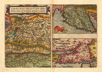
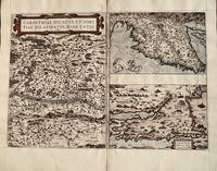
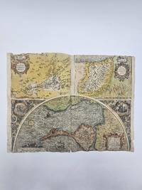
159816878Antwerp: Christopher Platin 1598. Other. A very good example in excellent condition. 332 by 4850mm 13 by 191 inches. Original copper engraving published 1598 in a French edition of the Theatrum Orbis Terrarum. Finely hand-colored in wash and outline. There are three maps on one plate each showing a title cartouche. Villages and towns are shown as miniature views. Ortelius was born on 14 April 1527 in the city of Antwerp which was then in the Habsburg Netherlands modern-day Belgium. The Orthellius family were originally from Augsburg a Free imperial city of the Holy Roman Empire. In 1535 the family had fallen under suspicion of Protestantism. Following the death of Ortelius's father his uncle Jacobus van Meteren returned from religious exile in England to take care of Ortelius. Abraham remained close to his cousin Emanuel van Meteren who would later moved to London. In 1575 he was appointed geographer to the king of Spain Philip II on the recommendation of Arias Montanus who vouched for his orthodoxy. He travelled extensively in Europe and is specifically known to have traveled throughout the Seventeen Provinces; in southern western northern and eastern Germany e.g. 1560 15751576; France 15591560; England and Ireland 1576; and Italy 1578 and perhaps twice or thrice between 1550 and 1558. Beginning as a map-engraver in 1547 he entered the Antwerp Guild of Saint Luke as an illuminator of maps. He supplemented his income trading in books prints and maps and his journeys included yearly visits to the Frankfurt book and print fair where he met Gerardus Mercator in 1554. In 1560 however when travelling with Mercator to Trier Lorraine and Poitiers he seems to have been attracted largely by Mercator's influence towards the career of a scientific geographer. Wikipedia Broe. 143 Christopher Platin unknown
15848Antwerp: Abraham Ortelius 1584. 1584. Three maps on one sheet- Carinthiae measures 13 1/4 x 9 1/2 inches. Top right map 9 1/4 x 6 1/8 bottom right 9 1/4 x 6 inches. Overall with gutters 13 1/4 x 19. Very good with one tiny hole in Austrian map. Ortelius. Map is in very good condition with one tiny circular hole in the large map. Color is not contemporary. Overall the condition of this 440 year old map makes it suitable for framing. Abraham Ortelius unknown
1584356976Abraham Ortelius. 1584. Poor condition numerous old repairs several closed tear affecting the image at the margins and the center fold. some dampstaining. 38.3x50.5 cm. Cadiz map engraved by Georg Hoefnagle. Image size: 38.8x48.7 cm. Latin text on verso Trimmed to the edges of the image at the top and bottom. Original hand coloring. weight: 0.1 lb. Abraham Ortelius. unknown
159511327Antwerp 1595. No binding. Very Good. 375 x 505 mm. in very good condition. Abraham Ortelius' map of two French regions. That on the left is the region of Le Mans with the city at the centre. On the right is Brittany and Normandy. The map was first published in the 'Additamentum' to Ortelius' 'Theatrum Orbis Terrarum' of 1595. This example with Spanish text on the verso is from the 1602 edition of the 'Theatrum'. The Le Mans is derived from a map by Matthaeus Ogerius in 1539. That of Brittany and Normandy from various sources but primarily Gerard Mercator's map of 1585. Van der Broecke cites also Bertrand d'Argentre's 1519-90 map of Brittany from 1588 and Lezin Guyet. This is an example of the first state. Abraham Ortelius 1527-98 developed an interest in cartography geography and history at an early age. He began as a 'kaarten afzetter' or illuminator of maps and would purchase single maps from booksellers and colour them for re-sale mounted on linen suitable for wall-hanging. At twenty he was entered in the Guild of St Luke at Antwerp. Ortelius travelled extensively in Europe and maintained regular correspondence with mapmakers historians and scientists acquiring information which was to form his greatest opus the 'Theatrum Orbis Terrarum'. What made the atlas stand out as the first modern atlas was its uniformity. They were produced in a similar style and none of the ancient Ptolemaic maps were included. The atlas was accompanied a catalogue of the authors whose source Ortelius had drawn upon in compiling the work. Without this list many cartographers of the day would remain unknown to us today. From its first appearance in 1570 the 'Theatrum' was far more comprehensive in scope than any contemporary work. In all over forty different editions were published with text in Latin Dutch German French Spanish English or Italian with the maps being frequently revised or replaced. By 1612 when the final edition was published the atlas contained no less than 128 maps. Provenance: private Jersey collection. Broecke 1996 37; Karrow 1993 1/188 & 189; Koeman 1967-70 Ort 28 no. 127. unknown
158461175<p>hand-coloured copper engraving. verso: Spanish text. EXTREMELY RARE.</p><p>The first European map of China appeared in Abraham Ortelius's atlas " Theatrum Orbis Terrarum" showing the area of Canton Mindanao no Luzon some islands to the North but only CuboCebu is marked and part of Japan – Spanish edition. An extremely important map for the Philippines here in the first state: there is no indication yet of' 'Las Philippinas' as will be shown later in the second state on the long elongated island just north of Borneo in the position and orientation of Palawan but apparently not based on Spanish knowledge.<br />Ortelius was a notable Dutch cartographer and the publication of this atlas in 1570 marked an epoch in the history of cartography. It was the first uniformly sized systematic collection of maps of the countries of the world based only on contemporary knowledge since the days of Ptolemy & in that sense may be called the first modern atlas; although that term itself was not used until 20 years later by Mercator. The Theatrum was re-issued in 42 editions with 5 supplements with text in Latin Dutch German French Spanish Italian & English between the years 1570-1612. The protrusion of a Southern landmass initially called 'Beach' by Marco Polo is shown South of "Java Major" alluding to Australia. Reference: Tooley Mapmakers S.38; Koeman III Ort 29 B; Walter Japan Nr. 11F; Karrow Mapmakers Nr. 1/152; Landmarks of Mapmaking pict. p. 21; Phillips Atlases 396; OAG Japan a cartographic vision pl. 11F; Suárez: Early Mapping… p. 170-1; Karrow Mapmakers p. 479; Lietz Insulae Indiae Orientalis 36th IMCoS Symposium Manila 2018 Gallery of Prints & Ayala Museum p.12.</p><p>Condition: Very good.</p> published in Antwerp.
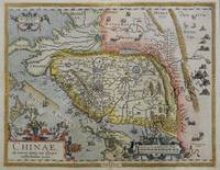
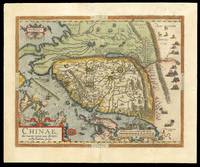
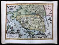
158415641Antwerp: Plantin Press 1584. 450 by 540mm. 17.75 by 21.25 inches. Engraved map with hand colour loss to top right margin skilfully reinstated. The earliest printed map to focus on China and the first to illustrate the Great Wall. It was the first western map of China drawn directly from the findings of the Portuguese mapmaker Luis Jorge de Barbuda or Ludovicus Georgius. Barbuda was a Jesuit and he made a manuscript map of China from information on the area gathered by the Jesuit mission. Arias Montanus passed this map on to Ortelius. He issued this first separately published map of China in 1584 which remained the standard map of China for over fifty years. The map is oriented to the west. Japan is shown on a curved projection borrowing from Portuguese sources. Wind wagons are shown in the north a Chinese invention that also became popular in the Low Countries. The text on the reverse of the map is in Latin and gives an insight into the climate national features inhabitants and economy of China at that time. Abraham Ortelius is one of the most famous of the early mapmakers and publishers. His 'Atlas of the Whole World' 'Theatrum Orbis Terrarum' was first published in 1570 the first uniformly sized systematic collection of maps and hence can be called the first 'Atlas'. These beautiful maps were elegantly engraved by Frans Hogenberg. Plantin Press], unknown
158415208Antwerp: Plantin Press 1584 1595. 440 by 550mm. 17.25 by 21.75 inches. Hand-coloured engraved map with fine original colour. The earliest printed map to focus on China and the first to illustrate the Great Wall. It was the first western map of China drawn directly from the findings of the Portuguese mapmaker Luis Jorge de Barbuda or Ludovicus Georgius. Barbuda was a Jesuit and he made a manuscript map of China from information on the area gathered by the Jesuit mission. Arias Montanus passed this map on to Ortelius. He issued this first separately published map of China in 1584 which remained the standard map of China for over fifty years. The map is oriented to the west. Japan is shown on a curved projection borrowing from Portuguese sources. Wind wagons are shown in the north a Chinese invention that also became popular in the Low Countries. The text on the reverse of the map is in Latin and gives an insight into the climate national features inhabitants and economy of China at that time. Abraham Ortelius is one of the most famous of the early mapmakers and publishers. His 'Atlas of the Whole World' 'Theatrum Orbis Terrarum' was first published in 1570 the first uniformly sized systematic collection of maps and hence can be called the first 'Atlas'. These beautiful maps were elegantly engraved by Frans Hogenberg. Plantin Press], unknown
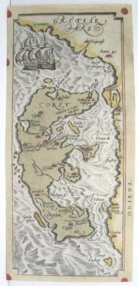
1590M3046Antwerp 1590. Very Good; left and lower margins extended. Size : 233x100 mm 9.125x3.875 Inches Coloring: Original Hand Coloring Category: ; Maps Europe Greece Macedonia unknown
1579200024AG1579. Antwerp Ortelius 1579. Original hand-coloured engraving. Plate Size: 49.3 cm x 35.3 cm. Sheet Size: 53.1 cm x 42 cm. Original map. Very good condition with some signs of browning to the outer margins only. Slight creasing to the top right coner of map. Professionally repaired tear to lower centre fold barely noticeable given the quality of the workmanship. Latin text on reverse. Broecke 14ab.2; Koeman III 95299610:31; Wolff America S. 95; Lowery 65. A pair of stunning maps from the late 16th Century Theatrum Orbis Terrarum showing the northwest Pacific coast of Mexico and the Greater Antilles in the Caribbean. All these regions were first explored and settled by the Spanish in the 1490s and still under Madrid's control when Ortelius produced his renowned cartographic work. Among the settlements shown on the Mexican map are Culiacan and the Spanish settlement of Villa S. Michaelis with its cathedral clearly marked. Reliefs are depicted pictorially with mountains and rivers identified and a large forest/grove also shown. A large but narrow island lies just off the coast. Large decorative cartouche with Ortelius's characteristic ornamental straps lies of the coast with explanatory annotations in Latin text. Smaller title cartouche in the top right corner of map also. The map below illustrates the Greater Antilles including the Cayman Magnus and the Caymanes Cuba 'Aity sive Spaniola' Hispaniola Jamaica the Bahamas 'St. Jois Insula' St. Johns Virgin Islands and the Barbados Islands all in fine detail. Havana is clearly identified along with other major settlements throughout the islands. St. Lucia is just about included lying within the map border. The section of South Florida also shows suggestion of the Florida Keys which was uncommon for this era. To the west Yucatan can be seen breaching the map boundary. A decorative title cartouche beautifully adorned with two birds lies at the lower part of the map. Unlike the waters of the Mexican map above it the seas of this map appear choppy for the two ships depicted. Valuably laden Spanish galleons would have traversed these stretches of water bringing the riches of the New World across the Atlantic to Spain. Making use of a knowledge of Greek Mythology two particularly perilous areas are designated: amid the Bahamas a treacherous stretch of water is labelled 'Carybdis Magna' while off to the west of Hispaniola lies the dangerous 'Scyila Magna.' An interesting cartographic error is evident on both maps: the Tropic of Cancer is mislabeled as the southern 'Tropicus Capricorni'. Abraham Ortelius was a Flemish cartographer and geographer conventionally recognized as the creator of the first modern atlas the Theatrum Orbis Terrarum Theatre of the World. He was one of the most notable figures of the Dutch school of cartography during its golden age approximately 1570s-1670s. unknown
1587239611Antwerp: Abraham Ortelius 1587. unbound. Map. Uncolored engraving. Image measures 14" x 19.5".<br/> <br/> These two maps on one sheet detail areas of western Mexico above and the Greater Antilles below. Ortelius created them from information compiled by other mapmakers such as Mercator Guttierez and Alsons de Sata Cruz. These sources allowed him to include a wealth of detailed information that is mostly if not entirely accurate. Above the map of western Mexico shows the area around Culiacan and the Spanish settlement of Villa S. Michaels which was notable in the period for its silver mines. It begins at the Yucatan and extends through the Cayman Magnus and the Caymanes. The map below illustrates the Greater Antilles including Cuba Hispaniola Jamaica St. Jois Insula St. Johns the Bahamas Virgin Islands and the Windward Islands all in impressive detail. The section of South Florida also shows suggestion of the Florida Keys which was uncommon for these period. A notable error is that the Tropic of Cancer is labelled as the Tropic of Capricorn. A highly decorative note with strapwork and foliage fills the acific Ocean to the left of Mexico and provides information about the upper map. The lower map also has a framed cartouche with birds perched atop it. Two ship illustrations float in the choppy seas around the islands. The map is a first state from the 1587 French edition of Ortelius's "Theatrum Orbis Terrarum." It is in good condition with no chips or tears. Stain at the center seam in the lower margin not affecting the image some overall stains. French text on verso. Abraham Ortelius 1527--1598 a Flemish cartographer and geographer is widely regarded as one of the important and influential cartographers in history. He is known for his "Theatrum Orbis Terrarum" which was the first modern atlas. This map is an uncommon uncolored example of this wonderful map by Ortelius.<br/> <br/> Abraham Ortelius unknown