ORTELIUS, AbrahamBiblio.com
213 résultats
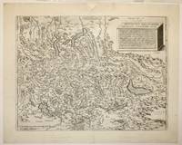
15982511641598. Map. Engraving. Image measures 13.5 x 18 inches. Sheet measures 16.5 x 20.5".<br/> <br/> This 1598 map of Switzerland is centered on Lake Lucerne and include much of Northern Italy. Oriented with south to the top the map extends from Lakes Como and Maggiore down north to Lake Constance. This map marked considerable progress in the mapping of Switzerland including as it does significant cities and locales. Furthermore a plinth rendered in three dimensions in the upper right corner of the map bears an inscription describing the geography of the region in Swiss miles. Given its wealth of information the map served as a productive model for Abraham Ortelius's map of Switzerland as published in his 1570 "Theatrum Orbis Terrarum" considered the first modern atlas of the world. The map is in good condition with repair to top center seam margin some foxing. French text on verso. Aegidius Tschudi 1505-1572 was a prominent member of Swiss society best known for his history of the early Swiss Confederacy Chronicon Helveticum. While his findings were greatly influenced by the prestige of his family his work did contribute to a considerable increase in knowledge of the Confederacy as it began in the 14th century and consequently developed.<br/> <br/> unknown
159816774Antwerp: Platin 1598. Other. A very good example a small older mended clear split in the upper centerfold. 350 by 460mm 13 by 18 inches. Original antique copper engraving published 1598 in a French textedition of the Theatrum Orbis Terrarum. Finely hand-colored in wash and outline. The map is ornated with three cartouches in the lower right corner the title cartouche in the upper right corner we find a small cartouche with privilegium and in the upper left corner a small cartouche with a milage scale. Villages and towns are shown as miniature views moreover the map is ornated with ships sea monsters and animals as well a compass rose in the sea. Ortelius was born on 14 April 1527 in the city of Antwerp which was then in the Habsburg Netherlands modern-day Belgium. The Orthellius family were originally from Augsburg a Free imperial city of the Holy Roman Empire. In 1535 the family had fallen under suspicion of Protestantism. Following the death of Ortelius's father his uncle Jacobus van Meteren returned from religious exile in England to take care of Ortelius. Abraham remained close to his cousin Emanuel van Meteren who would later moved to London. In 1575 he was appointed geographer to the king of Spain Philip II on the recommendation of Arias Montanus who vouched for his orthodoxy. He travelled extensively in Europe and is specifically known to have traveled throughout the Seventeen Provinces; in southern western northern and eastern Germany e.g. 1560 15751576; France 15591560; England and Ireland 1576; and Italy 1578 and perhaps twice or thrice between 1550 and 1558. Beginning as a map-engraver in 1547 he entered the Antwerp Guild of Saint Luke as an illuminator of maps. He supplemented his income trading in books prints and maps and his journeys included yearly visits to the Frankfurt book and print fair where he met Gerardus Mercator in 1554. In 1560 however when travelling with Mercator to Trier Lorraine and Poitiers he seems to have been attracted largely by Mercator's influence towards the career of a scientific geographer. Wikipedia Broe. 28 Platin unknown
1598LBW-1404Anvers 1598 82 x 107 mm.
1592273298Antwerp: Abraham Ortelius 1592. unbound. Map. Uncolored engraving. Sheet measures 16" x 21".<br/> <br/> This beautiful 1588 map by Abraham Ortelius depicts Holland or the Netherlands in exceptional detail. The map covers the regions near the Wadden Sea roughly covering modern day provinces of North Holland South Holland and Utrecht. The map centered on Amsterdam is oriented with north to the left. Topographical and geographical features such as mountains and cities are beautifully rendered in profile.<br> <br> The waters surrounding the region are shown with waves and include several illustrations of ships throughout. This is the first state of the map with later states showing a stippled sea rather than waves. Includes a large strapwork title cartouche scale of miles with a divider in the lower left. The Royal coat of arms is presented in the top left. The map also includes a 16-point compass rose.<br> <br> Ortelius based this map on the work of Jacob van Daventer. Published in the 1588 edition of Ortelius' famous "Theatrum Orbis Terrarum" which is historically considered the first modern atlas. Based on the text on verso only 300 copies of this particular edition were ever printed van der Broecke 79.<br> <br> The map is in good condition with minor wear along the original centerfold. Minor foxing at places. Original plate mark is visible. Latin text on verso.<br> <br> Abraham Ortelius 1527--1598 a Flemish cartographer and geographer is widely regarded as one of the important and influential cartographers in history. He is known for his "Theatrum Orbis Terrarum" which was the first modern atlas. Hard to find in black and white.<br/> <br/> Abraham Ortelius unknown
1592273298Antwerp: Abraham Ortelius 1592. unbound. Map. Uncolored engraving. Sheet measures 16" x 21".<br/><br/> This beautiful 1588 map by Abraham Ortelius depicts Holland or the Netherlands in exceptional detail. The map covers the regions near the Wadden Sea roughly covering modern day provinces of North Holland South Holland and Utrecht. The map centered on Amsterdam is oriented with north to the left. Topographical and geographical features such as mountains and cities are beautifully rendered in profile.<br><br>The waters surrounding the region are shown with waves and include several illustrations of ships throughout. This is the first state of the map with later states showing a stippled sea rather than waves. Includes a large strapwork title cartouche scale of miles with a divider in the lower left. The Royal coat of arms is presented in the top left. The map also includes a 16-point compass rose.<br><br>Ortelius based this map on the work of Jacob van Daventer. Published in the 1588 edition of Ortelius' famous "Theatrum Orbis Terrarum" which is historically considered the first modern atlas. Based on the text on verso only 300 copies of this particular edition were ever printed van der Broecke 79.<br><br>The map is in good condition with minor wear along the original centerfold. Minor foxing at places. Original plate mark is visible. Latin text on verso.<br><br> Abraham Ortelius 1527--1598 a Flemish cartographer and geographer is widely regarded as one of the important and influential cartographers in history. He is known for his "Theatrum Orbis Terrarum" which was the first modern atlas. Hard to find in black and white.<br/><br/> Abraham Ortelius unknown books
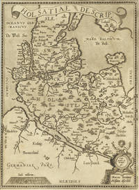
159827467Antwerpen 1598. Other. In excellent condition. 340 by 248mm 13 by 9 inches. Hand-Colored Original Copperplate Engraving by Abraham Ortelius depicting Holsatiae Descrip. Published Antwerpen 1598. Sheet: 340 by 248mm 13 by 9 inches. A fine and original hand-colored example of Ortelius's celebrated cartographic work documenting this region of Germany with the precision and decorative artistry characteristic of the 15900s. Abraham Ortelius 1527-1598 was a Flemish cartographer and geographer from Antwerp widely regarded as the creator of the first modern atlas. His landmark publication Theatrum Orbis Terrarum 1570 set the standard for atlas-making for the next century presenting uniform copper-engraved maps with scholarly commentary. By Ortelius's death the Theatrum had appeared in 25 editions in seven languages. In 1575 King Philip II of Spain appointed him Royal Geographer. His maps engraved with extraordinary precision are among the most sought-after in antique cartography held in collections including the Plantin-Moretus Museum in Antwerp the Library of Congress and the British Library.This original copperplate engraving with original hand coloring depicts the region of Holsatiae Descrip. published in Antwerpen 1598. The map records the political and geographic boundaries of the region as understood in 1598 offering a fascinating window into the history of German territorial organization. Sheet measures 340 by 248mm 13 by 9 inches. In good condition overall with minor signs of age appropriate for a 16th-century engraving. Ready to frame. unknown
1584803Antwerp: Abraham Ortelius 1584. 17 x 22 inches. Excellent condition for its age. This is a map showing the Adriatic Ocean and neighboring villages of Croatia Bosnia HerzegovinaHungary to the north and Slovenia. Nicely colored by hand at a date later than time of publication the map contains a contemporary layout of the Balkans region. Abraham Ortelius unknown
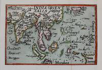
1588M8273Antwerp c. 1588. Very Good backed on acid free tissue paper for long term preservation. Notes: Miniature map of South East Asia published in Antwerp around c. 1588 by Philip Galle. This map comes from a pocket version of Abraham Ortelius’ folio atlas of China published in 1584. It is from the second series of plates in his atlas which were improved upon in terms of spatial dimension by its predecessors. Size : 75x115 mm 2.95x4.53 Inches Coloring: Hand Colored Category: Maps Asia Central India & Sri Lanka / Ceylon; Maps Asia South East; unknown
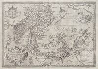
158163816<p>hand-coloured copper engraving. RARE. Stunning well-known map from 'Theatre de L'Univers contenant les cartes de tout le monde'.</p><p>This is the first French edition of his celebrated atlas - the FIRST in the World: 'Theatrum Orbis Terrarum" which was first published in Latin in 1570. The work was published by Christofle Plantin for Ortelius between 1581 and 1582 in Anvers Antwerp Belgium. Shows India and Indonesia Japan and the Philippines still without Luzon and parts of the American and Australian coastlines and the first Western map to show Formosa Taiwan.</p><p>Ortelius was a notable Dutch cartographer and 'the publication of this atlas in 1570 marked an epoch in the history of cartography. It was the first uniformly sized systematic collection of maps of the countries of the world based only on contemporary knowledge since the days of Ptolemy & in that sense may be called the first modern atlas; although that term itself was not used until 20 years later by Mercator. The Theatrum was re-issued in 42 editions with 5 supplements. with text in Latin Dutch German French Spanish Italian & English between the years 1570-1612. The protrusion of a Southern landmass initially called 'Beach' by Marco Polo is shown South of "Java Major" alluding to another "necessary" suspected landmass to keep the round earth balanced: Australia… Reference: Quirino p. 76; Cortazzi Isles of Gold p. 20 & 17; Walter Japan Nr. 11D; Broecke #166; Tooley Maps of Australia Nr. 937; Clancy Terra Australis Map 5.16; Clancy/R. S. 44/45/46; Suarez Southeast Asia; Farbabb. S. 166: Parry South Indian Islands S.; 78 mit Abb:Koeman III 8400:31:vdB 166.1; Ort 29 B Latin ed.; Lietz Insulae Indiae Orientalis 36th IMCoS Symposium Manila 2018 Gallery of Prints & Ayala Museum p.101.</p><p>Condition: centrefold as issued.</p> Anvers (Antwerp), Belgium.
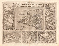
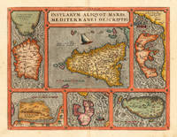
15791111150112Antwerp 1579. Map. Very Good. Antwerp: Theatrum Orbis Terrarum 1579. 47.0 x 35.6 cm. Fully hand-colored copper-plate engraved chart of the Mediterranean islands separated into 6 panels allowing each isle to be set to a different scale. Title is top and center framed. Clean sheet with moderate toning to outer edges. Slight staining to lower left corner. Minor chipping to corners. Light vertical crease along center of sheet from atlas extraction. Colors remain bright and vivid. Lines are crisp and clean.<br><br>Abraham Ortelius was a Flemish cartographer and geographer generally recognised as the creator of the first modern atlas the Theatrum Orbis Terrarum Theatre of the World. He is also believed to be the first person to imagine that the continents were joined together before drifting to their present positions. His publications were known for their detail and accuracy as well as their asthetic beauty.<br><br>The following was extracted from a later edition of Orteliuss Theatrum Orbis Terrarum. A well-preserved map with minimal flaws. Please feel free to view our photographs of this piece. Antwerp unknown
157324542Antwerp: Platin 1573. Other. A very good example printed on excellent German paper. In excellent condition. 365 by 478mm 14 by 18 inches. Original antique copper engraving from the 'Theatrum Orbis Terrarum' by Abraham Ortelius the world's first modern atlas published in Antwerp 1573. Depicting Mediterranean Islands this map is a fine example of 1570s European cartography. Image: 365 by 478mm 14 by 18 inches. An attractive and historically significant 16th-century map for the discerning collector. Abraham Ortelius 15271598 was a Flemish cartographer and geographer born in Antwerp. He is widely regarded as the creator of the first modern atlas the 'Theatrum Orbis Terrarum' Theatre of the World first published in 1570 by Gilles Coppens de Diest in Antwerp. Considered the world's first true atlas it established the modern format of uniform standardized maps bound together in a single volume. Appointed Geographer to King Philip II of Spain in 1575 Ortelius was one of the most influential figures in the history of cartography. His maps are held in the collections of the British Library the Library of Congress and major European institutions. The 'Theatrum' went through more than 30 editions and was translated into multiple languages making Ortelius's maps among the most sought-after in the world of antique cartography.Decorative double page map showing six islands in the Mediterranean Islands Sicily Sardinia Corfu Malta Djerba Elba. Sicily is prominently displayed in the center of the map above the title cartouche.A fine example from Theatrum Orbis Terrarum Antwerp sought after by collectors of antique maps of Italy antique maps of Mediterranean Islands and antique copper engravings for sale. In good condition consistent with age. Light age-toning to the sheet as expected for a 16th-century engraving. Centerfold as published. Broe. 141 Platin unknown
159816886Antwerp: Christopher Platin 1598. Other. A very good example in excellent condition. 360 by 475mm 14 by 18 inches. Original copper engraving published 1598 in a French edition of the Theatrum Orbis Terrarum. Finely hand-colored in wash and outline. Decorative doublepage map showing six islands in the Mediterranean Islands Sicily Sardinia Corfu Malta Djerba Elba. Sicily is prominently displayed in the center of the map above the title cartrouche. Ortelius was born on 14 April 1527 in the city of Antwerp which was then in the Habsburg Netherlands modern-day Belgium. The Orthellius family were originally from Augsburg a Free imperial city of the Holy Roman Empire. In 1535 the family had fallen under suspicion of Protestantism. Following the death of Ortelius's father his uncle Jacobus van Meteren returned from religious exile in England to take care of Ortelius. Abraham remained close to his cousin Emanuel van Meteren who would later moved to London. In 1575 he was appointed geographer to the king of Spain Philip II on the recommendation of Arias Montanus who vouched for his orthodoxy. He travelled extensively in Europe and is specifically known to have traveled throughout the Seventeen Provinces; in southern western northern and eastern Germany e.g. 1560 15751576; France 15591560; England and Ireland 1576; and Italy 1578 and perhaps twice or thrice between 1550 and 1558. Beginning as a map-engraver in 1547 he entered the Antwerp Guild of Saint Luke as an illuminator of maps. He supplemented his income trading in books prints and maps and his journeys included yearly visits to the Frankfurt book and print fair where he met Gerardus Mercator in 1554. In 1560 however when travelling with Mercator to Trier Lorraine and Poitiers he seems to have been attracted largely by Mercator's influence towards the career of a scientific geographer. Wikipedia Broe. 141 Christopher Platin unknown
1584299318Antwerp: Abraham Ortelius 1584. unbound. Map. Engraving. Image measures 14" x 18 3/4". Light staining and toning on right margin but otherwise is good condition.<br/> <br/> A representation of some islands in the Mediterranean Sea. Abraham Ortelius 1527-1598 a Flemish cartographer and geographer is widely regarded as one of the important and influential cartographers in history. He is known for his "Theatrum Orbis Terrarum" which was the first modern atlas. Van den Broecke #141<br/> <br/> Abraham Ortelius unknown
1584299318Antwerp: Abraham Ortelius 1584. unbound. Map. Engraving. Image measures 14" x 18 3/4". Light staining and toning on right margin but otherwise is good condition.<br/><br/> A representation of some islands in the Mediterranean Sea. Abraham Ortelius 1527-1598 a Flemish cartographer and geographer is widely regarded as one of the important and influential cartographers in history. He is known for his "Theatrum Orbis Terrarum" which was the first modern atlas. Van den Broecke #141<br/><br/> Abraham Ortelius unknown books
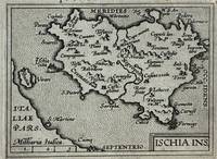
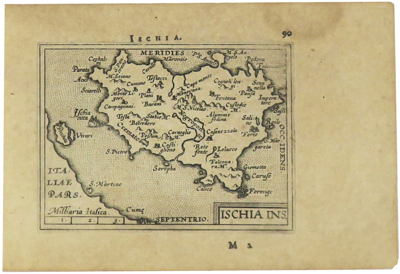
1595223506Antwerp: Philippe Galle 1595. unbound. very good. Miniature map. Uncolored engraving. Image measures 3 1/8" x 4.25".<br/><br/> Great miniature map of Ischia off the coast of Naples detailing the volcanic landscape. From the 1595 pocket edition of Ortelius' "Theatrum Orbis Terrarum" or "Epitome" with text by Pieter Heyns. With Latin text on verso. Small tear and chip to upper right light staining to lower margin.<br/><br/> Philippe Galle unknown books
1595327493Antwerp: Philippe Galle 1595. unbound. Miniature map. Uncolored engraving. Image measures 3 1/8" x 4.25".<br/> <br/> Miniature map of Ischia off the coast of Naples detailing the volcanic landscape. From the 1595 pocket edition of Ortelius' "Theatrum Orbis Terrarum" or "Epitome" with text by Pieter Heyns. With Latin text on verso. Small repair to upper margin.<br> <br> Abraham Ortelius 1527--1598 a Flemish cartographer and geographer is widely regarded as one of the important and influential cartographers in history. He is known for his "Theatrum Orbis Terrarum" which was the first modern atlas.<br/> <br/> Philippe Galle unknown
1598LBW-1405[Anvers, 1598]. 82 x 106 mm.
1573311532Antwerp: Ortelius Abraham 1573. framed. Map. Color engraving. Image measures 14 3/8" x 19.75". In gilt frame with empire French matting 23 x 28 1/2 inches.<br/> <br/> Gorgeous 16th century map of Italy. Elevations are beautifully colored and major towns are noted in red. Part of the Balkans Corsica and northern Sardinia are included along with part of Switzerland. Monaco is noted to the West. It was Ortelius's first map of Italy with a depiction of Neptune embracing and kissing a Neirid merwoman. A Sphinx perches atop the distance scale cartouche. Seven ships complete the composition. Some foxing and toning but otherwise a beautiful example of this uncommon edition. <br> <br> Abraham Ortelius 1527--1598 started his career as a Flemish map colorist eventually becoming a publisher cartographer and geographer. He widely regarded as one of the important and influential cartographers in history. He is known for his "Theatrum Orbis Terrarum" which was the first modern atlas. Van den Broecke 118.<br/> <br/> Ortelius, Abraham unknown
1598LBW-1424[Anvers, 1598]. 82 x 102 mm.
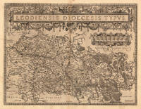
1584675Antwerp: Abraham Ortelius 1584. 19 1/2 x 14 2/4 inches. Very good condition. Ortelius was mentored by Mercator. The friendship yielded a mapmaking enterprise of great success. This map of the diocese of Liege. The main cartouche spreads across and covers the entire 2 pages. There is a secondary mileage cartouche scale. There is a major river through Liege. The Meuse runs thrash the map with primal impact showing the riverine regime as important to a large area. There is a multitude of small towns colored red. This is a very good copy with color not applied at publication. Ortelius oriented the west at the top of the map. Abraham Ortelius unknown
159813893Antwerp 1598. Other. In excellent condition. 380 by 497mm 15 by 19 inches. Original antique copper engraving published 1598 in a French text edition of the " Theatrum Orbis Terrarum. Uncolored copy in a strong impression. The map is ornated a large title cartouche and below a decorative milage scale. This antique map shows Luttich in Belgium. The map is equipped with many small place names rivers woods etc. Ortelius was born on 14 April 1527 in the city of Antwerp which was then in the Habsburg Netherlands modern-day Belgium. The Orthellius family were originally from Augsburg a Free imperial city of the Holy Roman Empire. In 1535 the family had fallen under suspicion of Protestantism. Following the death of Ortelius's father his uncle Jacobus van Meteren returned from religious exile in England to take care of Ortelius. Abraham remained close to his cousin Emanuel van Meteren who would later moved to London. In 1575 he was appointed geographer to the king of Spain Philip II on the recommendation of Arias Montanus who vouched for his orthodoxy. He travelled extensively in Europe and is specifically known to have traveled throughout the Seventeen Provinces; in southern western northern and eastern Germany e.g. 1560 15751576; France 15591560; England and Ireland 1576; and Italy 1578 and perhaps twice or thrice between 1550 and 1558. Beginning as a map-engraver in 1547 he entered the Antwerp Guild of Saint Luke as an illuminator of maps. He supplemented his income trading in books prints and maps and his journeys included yearly visits to the Frankfurt book and print fair where he met Gerardus Mercator in 1554. In 1560 however when travelling with Mercator to Trier Lorraine and Poitiers he seems to have been attracted largely by Mercator's influence towards the career of a scientific geographer. Wikipedia Broe. 64. State 1/3. unknown
1579M8772Antwerp c. 1579. Margins are trimmed closely and laid on 19th century paper. Otherwise very good. . Notes: Map of Baltic region and Poland from the late 16th century with decorative border with sea monsters and tall ships. Size : 80x107 mm 3.15x4.21 Inches Coloring: Black & White Category: Maps Europe Estonia Latvia; Maps Europe Poland Lithuania; unknown
15903400<p>Very Good. c1590. 16th century map with original hand-colored outlines of Luxembourg. Decorative cartouche. Some foxing most apparent to margins. Latin text to verso with colored historiated initial. Otherwise a handsome copy. Please see image. Plate size approximately 19 1/2 x 14 1/2 in. Overall size approx. 21 1/2 x 17 1/2 in 550 x 445 mm.; 1 pages; All shipments through USPS insured Priority Mail. .</p>
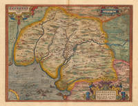
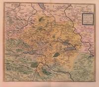
15923013<p>Paper size: 426 x 534 mm. Image size: 367 x 432 mm. 16th century map in original hand-coloring. Hinged to green card stock. Depicts lakes rivers heights forests and towns/cities. Ortelius 94. Van den Broecke 2nd ed. p. 303. ; 426 x 534 mm; All shipments through USPS insured Priority Mail.</p> Abraham Ortelius
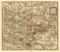
159827386Antwerpen: Moretus 1598. Other. On the sheet are two brown spots visible else in very good condition. 368 by 430mm 14 by 17 inches. Hand-Colored Original Copperplate Engraving by Abraham Ortelius depicting Mansfeldiae Comitatus Descriptio auctore Tilemanno Stella. Sig. Published Antwerpen Moretus 1598. Sheet: 368 by 430mm 14 by 17 inches. A fine and original hand-colored example of Ortelius's celebrated cartographic work documenting this region of Germany with the precision and decorative artistry characteristic of the 15900s. Abraham Ortelius 1527-1598 was a Flemish cartographer and geographer from Antwerp widely regarded as the creator of the first modern atlas. His landmark publication Theatrum Orbis Terrarum 1570 set the standard for atlas-making for the next century presenting uniform copper-engraved maps with scholarly commentary. By Ortelius's death the Theatrum had appeared in 25 editions in seven languages. In 1575 King Philip II of Spain appointed him Royal Geographer. His maps engraved with extraordinary precision are among the most sought-after in antique cartography held in collections including the Plantin-Moretus Museum in Antwerp the Library of Congress and the British Library.This original copperplate engraving with original hand coloring depicts the region of Mansfeldiae Comitatus Descriptio auctore Tilemanno Stella. Sig. published in Antwerpen Moretus 1598. The map features a decorative Baroque cartouche containing the title inscription. A distance scale is incorporated within the cartouche or alongside it. The map records the political and geographic boundaries of the region as understood in 1598 offering a fascinating window into the history of German territorial organization. Sheet measures 368 by 430mm 14 by 17 inches. In good condition overall with minor signs of age appropriate for a 16th-century engraving. Ready to frame. Broe. 94 Koeman 32 Moretus unknown