Petermann, A[ugust]Antiquariat.de

236 résultats
185832039ABGotha, J. Perthes, 1858-1906. 4°, jeder Band zwischen ca. 300 und 500 S. mit zahlr. (oftmals farbigen) Ausklapp-Tafeln und Falt-Karten, die ersten 4 Bände (1858-1863) als schwarze original Leineneinbände mit goldener Deckel- und Rückenbeschriftung sowie reicher Deckelbildprägung, der Band 1868 als schlicher schwarzer Pappband der Zeit, dann (1870-1906) Halbleinen-Einbände der Zeit mit Rückenschildern bzw. goldener Rückenbeschriftung und Musterpapierbezügen, alle Bände in Originalausgabe alle Bände unten mit Rückensignaturschildchen, die Rückenkanten der ganz frühen Bände stellenw. angeplatzt, wenige Bände oben am Rücken etwas angerändert, beim schlichten Pappband von 1868 der Rücken beschädigt und mit Fehlstellen (innen aber bindungsstab
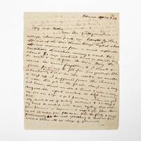
1854369733Palmas Panama 1854. 2pp. single 4to sheet. With: Carte-de-visite photograph of Mayo signed and inscribed to his sister on verso. Folds minor separations. 2pp. single 4to sheet. With: Carte-de-visite photograph of Mayo signed and inscribed to his sister on verso. Seeking a low-level train or canal route to bridge the Atlantic and Pacific Oceans in late 1853 President Franklin Pierce ordered a U.S. Naval exploring expedition to participate in an international attempt affiliated with a venture by the Atlantic and Pacific Junction Company. Although ships from Great Britain New Grenada and the United States were involved the principle overland portion of the expedition through 40 miles of dense jungle would be led by Lieutenant Isaac G. Strain who had previously led exploring expeditions in Brazil Baja California and Chile. With a party of 27 officers and men and including the author of the present letter they entered the jungle on January 20 1854.<br /> <br /> Problems began almost immediately. While puting ashore a boat was swamped and a portion of the party's provisions lost. Next the route Strain had been tasked with following contained no gap in the cordillera as had been previously believed. Led through the jungle by several groups of indigenous people the promise of a few days hike turned into months of wandering in the jungle before being abandoned by the guides. Subsisting on plantains and bananas and drinking river water Stain divided his men with an advance party striking out to seek rescue. On March 9 forty-nine days after starting from Caledonia Bay Strain and his advance party reached Yavisa; it would be another nearly three weeks before the main body was rescued but not before at least five had died of starvation or disease. Sometimes compared with the trials of the crew of the Essex or the members of the Donner Party the men on the Darien expedition endured extreme harship and resorted to unspeakable things. <br /> <br /> This remarkable letter was written by one of the expedition's survivors shortly after his rescue and return to civilization. George Upshur Mayo 1834-1896 was born into a prominent family in Norfolk VA. He attended the Virginia Military Institute served as an assistant engineer on the Strain Expedition was involved in the United States Geodetic Survey and was later a major in the Confederate Army. Here he writes:<br /> <br /> "My dear father From this filthy native village where our party are brought by the officers of the war steamer Virago English whose officers rescued us from a most deplorable condition starvation misery & want for about 70 days without bread or meat living on roots & nuts from the trees. May the rescue be never forgotten & I thank & give praises to God for his goodness. We abandoned & buried 4 or 5 in the woods as unable to keep up. I suffered from the cusano a worm that gets in the flesh also from a very bad knee. Almost unable to travel 3 miles a day. Unfavorable reports reached the U.S. concerning us. We are safe & go to Panama when we get well. My mind is out of sorts by medicine & sickness & my hand too weak to write more legibly. Will write from Panama or Aspinwall a respectable letter there. We are 100 miles from Panama. Had the party 8 days provisions only in the woods yet nothing to shield us from wind & storm & no change of garments. The suffering was intense & the rescue came at the most dreadful & important for our safety. I with 3 others on the river bank washing at sundown when the canoes came in sight. Captain Strain had no pants or underdraws to protect him from the briars & vermin. God be praised for rescue. Love to Annie. . . . In all probability will meet the Cyane at Aspinwall."<br /> <br /> A remarkable first-hand account of a desperate struggle for survival. unknown
1856E0560<p>3 volumes: xvii1537 pages with 90 lithographs plates including the usual expunged bathing plate many in color including 3 "facsimiles" of Japanese woodblock prints 2 folding; 6 maps and charts 2 folding; 79 woodcuts in the text; 2414414-1xi pages with 4 color lithographs of Chinese scenes; 2 uncolored natural history engraved plates; 6 hand-colored lithographs of birds; 10 hand-colored steel-engravings of fish; 5 lithographs of shells 2 hand-colored; 16 diagram plates of winds and currents; 14-page facsimile of Japanese language version of the U.S.-Japan treaty; 17 folding charts on 16 sheets; numerous woodcuts in the text; xliii17051 pages woodcut star charts throughout. Volume III titled "United States Japan Expedition. Observations on the zodiacal light from April 2 1853 to April 22 1855 . by Rev. George Jones A.M. chaplain United States Navy". Quarto 11½ x 8 ¾" bound in the original blind stamped cloth. Volume 1 rebacked with the original cloth spine laid down. Hill 1332; Sabin 30968 Stabbed signature of the author included. First edition of the House Issue.<br /><br />Detailed and profusely illustrated account of Perry's expedition to open Japan to the West; Upon his return to the U.S. his chief duty for the following year was to compile his reports of the expedition aided by Francis Hawks. The first volume has the account of the voyage and lithographs of the travel; the second volume has the natural history reports by D.S. Green and others and includes hand-colored plates of Japanese fishes and shells. In addition to the artist W. Heine from whose drawings a great number of the lithographs were made the daguerreotypist E. Brown Jr. went on the expedition taking what were undoubtedly the earliest photographic images of Japan many of them reproduced lithographically in this work. This copy with the nude bathing plate which was not included on the list of plates and not issued in all copies. <br /><br />In advance of his voyage to the Far East Commodore Perry read widely amongst available books about Tokugawa Japan. His research even included consultation with the increasingly well-known Japanologist Philipp Franz von Siebold who had lived on the Dutch island of Dejima for eight years before retiring to Leiden in the Netherlands. In 1852 Perry embarked from Norfolk Virginia for Japan in command of a squadron in search of a Japanese trade treaty. Aboard a black-hulled steam frigate he ported Mississippi Plymouth Saratoga and Susquehanna at Uraga Harbor near Edo modern Tokyo on July 8 1853. His actions at this crucial juncture were informed by a careful study of Japan's previous contacts with Western ships and what could be known about the Japanese hierarchical culture. He was met by representatives of the Tokugawa Shogunate who told him to proceed to Nagasaki where there was limited trade with the Netherlands and which was the only Japanese port open to foreigners at that time. Perry refused to leave and demanded permission to present a letter from President Millard Fillmore threatening force if he was denied. Perry ordered his ships to attack several buildings around the harbor to demonstrate US naval power. The Commodore was fully prepared for more hostilities if his negotiations with the Japanese failed and threatened to use unrestrained fire if the Japanese refused to negotiate. He sent two white flags to them telling them to hoist the flags when they wished a bombardment from his fleet to cease and to surrender. Perry's ships were equipped with new Paixhans shell guns capable of wreaking great destruction with every shell. The Japanese military forces could not resist Perry's modern weaponry; the term "Black Ships" in Japan would later come to symbolize a threat imposed by Western technology. Perry returned in February 1854 with twice as many ships finding that the delegates had prepared a treaty embodying virtually all the demands in Fillmore's letter. Perry signed the Convention of Kanagawa on March 31 1854 and departed mistakenly believing the agreement had been made with imperial representatives. The agreement was made with the Shogun the de facto ruler of Japan. On his way to Japan Perry anchored off Keelung in Formosa modern day Taiwan for ten days. Perry and crew members landed on Formosa and investigated the potential of mining the coal deposits in that area. He emphasized in his reports that Formosa provided a convenient mid-way trade location. Formosa was also very defensible. It could serve as a base for exploration as Cuba had done for the Spanish in the Americas. Occupying Formosa could help the US to counter European monopolization of the major trade routes. President Franklin Pierce declined the suggestion remarking such a remote possession would be an unnecessary drain of resources and that he would be unlikely to receive the consent of Congress. When Perry returned to the United States in 1855 Congress voted to grant him a reward of $20000 in appreciation of his work in Japan. Perry used part of this money to prepare and publish a report on the expedition in three volumes titled Narrative of the Expedition of an American Squadron to the China Seas and Japan. He was also advanced to the grade of rear-admiral on the retired list when his health began to fail as a reward for his services in the Far East.<br /><br /><strong>Condition: </strong>Wear and fading to cloth large map repair at with archival tape several others with stub tears and splitting to folds; light foxing spine ends rubbed with a few with chips corners bumped and rubbed through. Accompanied with encapsulated and graded signature of the author else good to very good. Due to the size and weight additional postage will be required.</p> A O P Nicholson hardcover
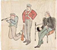
185334749Edo 1853. Watercolour and ink drawing on Japanese paper. A contemporary Japanese watercolour of Commodore Perry and members of his expedition produced at the moment of the American squadron’s arrival in Japan and the opening of sustained diplomatic contact between Japan and the United States.<br/> <br/> This lively drawing belongs to the immediate visual culture generated by Commodore Matthew C. Perry's arrival in Japan in 1853. Perry entered Edo Bay in July 1853 to deliver President Fillmore's request for a treaty and returned the following year leading to the Treaty of Kanagawa on 31 March 1854. The event prompted wide Japanese interest in the appearance dress equipment and conduct of the visiting Americans and images of the "Black Ships" and their crews circulated in manuscript painted and printed form. The composition presents three American figures isolated against the paper ground arranged almost as a study of types. At right Commodore Perry is shown seated in a chair wearing a dark naval coat and holding his hat. At center stands an armed crewman or marine in a red jacket holding a musket upright; at left another crewman kneels while looking through a telescope or spyglass. The emphasis falls on uniform posture weaponry and optical instrument details that would have marked the Americans as visually and technologically unfamiliar to Japanese observers. The drawing is especially interesting as a Japanese interpretation of the expedition distinct from the official American pictorial record produced by artists such as Wilhelm Heine. The Japanese manuscript images such as the present work preserve a different perspective shaped by local observation report and curiosity. unknown
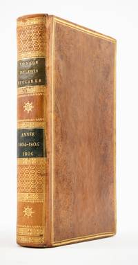
1810ST20849Paris: Chez Arthus-Bertrand 1810. First Edition in French. 205 x 128 mm. 8 x 5". xviii 443 1 pp.Translated into French by A. J. N. Lallemant. <br/> Contemporary flamed sheep covers with thick and thin gilt rule border smooth spine divided into panels by metope and pentaglyph roll panels either with rows of interlocking gilt circles or a gilt compass ornament two black morocco labels marbled endpapers. Folding engraved map by J. B. Tardieu. Wagner-Camp-Becker 6:3; Howes G-77; Sabin 26742; Graff Collection 1519; Wheat Trans-Mississippi 300. Very small loss to head of rear joint boards faintly abraded but the binding entirely solid and pleasing; a handful of leaves with small marginal tears or paper flaws one slightly larger but not affecting text approximately one-third of volume very mildly browned other trivial imperfections but still an excellent copy extremely clean and fresh internally.<br/> <br/> Issued three years after the original English text this is the initial printing in French—and the first in any foreign language—of an important firsthand account of the Lewis and Clark voyage of discovery written by a key figure both during and after the company’s undertaking; it is also and crucially the first edition to include a map of the expedition. Tardieu's map the first to mention the names Lewis and Clark noted important landmarks on the journey including the formidable Rocky Mountains the Columbia River and Fort Clatsop on the Pacific Coast where the expedition spent the winter of 1805-06. Our French edition also adds two letters of Clark not appearing in other editions of Gass—one to William Henry Harrison 2 April 1805 from Fort Mandan and one to Clark’s brother 23 September 1806 on the day the six-month return journey came to an end. Wheat observes that this work held special interest for the French as it provided much information about lands that had until the Louisiana Purchase been part of their domain. A carpenter by training Patrick Gass 1771-1870 was in charge of constructing winter accommodations for the party and his knowledge of building informs his observations here about forts and native architecture. This account was based on journals he kept during the explorations and it was an immediate success upon its first publication in Pittsburgh in 1807. The American public was hungry for information about the Western frontier and their curiosity was shared by Europeans particularly those considering emigration to the New World. Wagner-Camp observes that Gass "became one of the best-known members of the expedition for several reasons: his key role as sergeant brought his name up frequently in the journals of Lewis and Clark; his account was the first to be published; he was the first to have a biography written about him; and finally he outlived the other members of the Corps of Discovery by decades" dying at the age of 98. . Chez Arthus-Bertrand unknown
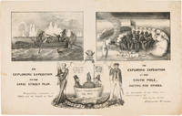
1838WRCAM55549New York: H.R. Robinson 1838. Lithograph 12 1/2 x 20 inches. Light foxing and soiling. Two short closed tears in the right edge and left edge of the sheet. Very good. A very rare print satirizing the recently undertaken United States Exploring Expedition commanded by Charles Wilkes. The Expedition departed in August 1838 and Robinson's eagerness to satirize it and the politicians who supported it is ample evidence that the endeavor was not universally popular. The print is made up of three humorous vignettes. "The upper left is Charles Wilkes in a rowboat with an oarsman and two members of the scientific corps who make observations with a transit or telescope and draw fauna. The upper right image depicts a group of sailors and Charles Wilkes huddled together on the snow surrounded by a ring of polar bears and an upturned rowboat foxes penguins and a campfire. They are flying an inverted U.S. flag to signal distress. At the bottom between the two titles is an inset of the three Navy Commissioners Isaac Chaucey Charles Morris and Alexander S. Wadsworth at sea in a bowl. They are framed by a shield surmounted by a jester and flanked on the left by a man in naval uniform James Kirke Paulding Secretary of the Navy and a sailor with a sad expression on the right" - Harry T. Peters Collection at the Smithsonian Institution online catalogue. The print is "Respectfully inscribed to the Secretaries of the Navy and Army and the Board of Navy Commissioners by their humble servant Robinson Crusoe." <br> <br> Not in Reilly's catalogue of American political prints in the Library of Congress though OCLC does locate a copy at the Library of Congress. That is one of two copies listed on OCLC the other copy is at the American Antiquarian Society. There are also copies in the Peters collection at the Smithsonian and at the Australian National Maritime Museum. OCLC 299947747 752795742. Herman J. Viola ed. MAGNIFICENT VOYAGERS THE U.S. EXPLORING EXPEDITION 1838-1842 Washington 1985 p.13. H.R. Robinson unknown books
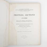
1872373132New York: Jules Bien 1872. First edition. Limited to 100 copies. 65 lithographed plates many folding preceded by 4pp. text. 4to. Original green cloth boards upper cover lettered in gilt rebacked endpapers renewed. Dampstaining. First edition. Limited to 100 copies. 65 lithographed plates many folding preceded by 4pp. text. 4to. This book was prepared to illustrate the work of the Hayden survey. It contains numerous panoramic illustrations many on folding sheets depicting sites in Wyoming Utah Colorado and Montana. This report contains the bulk of Henry Wood Elliott's art work for the Hayden Survey see preceding entry most of which was published nowhere else. These images are important because of their scientific contribution to several fields historical significance documentation of the Hayden expedition and their beauty and attention to detail. Elliott's illustrations were among the early images of many locations in the new territories of the West.<br /> <br /> From an edition of 100 copies issued in advance of the text. The Prefatory Note states p. 3: "A small edition of one hundred copies of the Profiles and Sections are issued in advance of the text for the purpose of placing them in the hands of the principal geologists in this country and in Europe. The first issue of two thousand copies in colors will be published with descriptions in about one year." We find no evidence that a subsequent edition in color was ever printed and it is stated of the present work in the Checklist of United States Public Documents 1789-1909 Washington: Government Printing Office 1909: "Originally intended to illustrate v. 4 of quarto series of reports but never thus used." <br /> <br /> The Hayden Survey was the most important of the four major government surveys of the American West undertaken after the Civil War the others being Powell King and Wheeler. Collectively these surveys filled in the map of the United States using accurate scientific methods to chart the land and investigate not only its geology but natural resources wildlife and plants as well. Schmeckebier Catalogue and Index of the Publications of the Hayden King Powell and Wheeler Surveys p. 32 #3 Jules Bien unknown
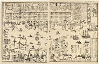
1855WRCAM46844Tokyo 1855. 24 1/2 x 16 inches. Matted. Old fold lines some minor wear and soiling. Near fine. Large wood block print comprised of two sheets showing the disposition of the Japanese soldiers and ships in preparation for the arrival of Commodore Perry's American fleet seen sailing into Tokyo harbor at the right side of the image. The top third of the print is comprised of text in Japanese characters. Three large American ships dominate the right side of the print while several smaller boats dot the rest of the harbor. The whole is dotted with Japanese characters denoting various people and places around the harbor. <br> <br> Perry first arrived in Japan on July 8 1853 with a fleet of four ships flying his pennant on the steam frigate Susquehanna. This first visit lasted ten days and culminated on July 14 with Perry's presentation of a letter from the President of the United States to the Japanese commissioners. Perry then absented himself for seven months returning on February 11 1854 for a stay of over four months. He negotiated a treaty opening Japan to trade with the western world providing for a U.S. consul in Japan and protecting visiting ships and crews. Perry's visit to Japan remains one of the most important events in the diplomatic history between western and eastern nations. <br> <br> A handsome print showing the Japanese side of this important historic event. unknown books
1853347471853. 31; 31; 61pp. plus a loose sheet. Original paper wrappers stitched. Contemporary manuscript annotations in red ink in one volume Scattered worming heavy in places. Some dampstaining and dust soiling. About very good.<br/> <br/> Separate Accounts of the Arrival of Commodore Perry<br/> <br/> Three fascinating Japanese manuscript accounts of the arrival of Commodore Perry to Japan in 1853. Then first Uraga Kurotone Ni Kansaru or "The Black Ship Arriving in Uraga" comprises the official government report of events when Perry steamed into Uraga Bay. This volume contains contemporary edits to the text in red ink. The second account of Perry's arrival Edo Urgga Bikoku Fune Torai Ikken or "Arrival of the Ships at Uraga" contains a double-page manuscript sketch of the coastline of Uraga Bay together with the disposition of Perry's ships. The final volume consists of a third manuscript entitled GASSHUKKO SHOKAN WAGE UTSUSHI a copy of the report on the Perry arrival prepared by Abe Masahiro Chief Senior Councillor in the Toguwara Shogunate which includes translations of the letters from Fillmore and Perry delivered by Perry on July 8 1853. Also with a single manuscript sheet that provides a description of Perry's ship. Vital contemporary manuscript accounts of this monumental transformation in Japanese foreign relations from significant Japanese participants in events. unknown
1853347471853. 31; 31; 61pp. plus a loose sheet. Original paper wrappers stitched. Contemporary manuscript annotations in red ink in one volume Scattered worming heavy in places. Some dampstaining and dust soiling. About very good.<br/> <br/>Separate Accounts of the Arrival of Commodore Perry<br/> <br/>Three fascinating Japanese manuscript accounts of the arrival of Commodore Perry to Japan in 1853. Then first Uraga Kurotone Ni Kansaru or "The Black Ship Arriving in Uraga" comprises the official government report of events when Perry steamed into Uraga Bay. This volume contains contemporary edits to the text in red ink. The second account of Perry's arrival Edo Urgga Bikoku Fune Torai Ikken or "Arrival of the Ships at Uraga" contains a double-page manuscript sketch of the coastline of Uraga Bay together with the disposition of Perry's ships. The final volume consists of a third manuscript entitled GASSHUKKO SHOKAN WAGE UTSUSHI a copy of the report on the Perry arrival prepared by Abe Masahiro Chief Senior Councillor in the Toguwara Shogunate which includes translations of the letters from Fillmore and Perry delivered by Perry on July 8 1853. Also with a single manuscript sheet that provides a description of Perry's ship. Vital contemporary manuscript accounts of this monumental transformation in Japanese foreign relations from significant Japanese participants in events. unknown books
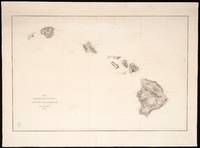
1850423<p><strong>Chart and Capt. Charles Wilkes Calling Card Details</strong>:<br />Lot of 15 black and white independently issued engraved charts on heavy paper bearing a printed oval stamp with Navy anchor and "U.S.Ex.Ex." and "Price thirteen cents" on each chart with occasional period manuscript notation on verso<br />engravers: G.W. Boynton J. Knight George G. Smith 2 and unsigned<br />dimensions: 26 1/2" x 19 1/2" approx. sheet size<br />condition: professionally conserved good condition working charts have manuscript notations</p><p>Capt. Charles Wilkes calling card:<br />as found with manuscript ink inscription<br />dimensions: 3 1/2" x 2 1/8"</p><p><strong>Please see </strong><u><strong>Part II</strong></u><strong>. for a list of the fifteen 15 U.S. Ex.Ex. chart titles and individual chart descriptions.</strong></p><p><strong>I. Brief History and Description of the U.S. Exploring Expedition</strong>:</p><p>Like a Homeric odyssey the United States Exploring Expedition 1838-1842 its six vessels2/ 346 man crew3/ of scientists artists naval officers and other personnel commanded by then U.S. Navy Lieut. Charles Wilkes 1798-1877 set out on a four year journey that touched six continents covered 87 780 miles and set a circuitous course en route to mapping and exploring the islands of the South Pacific and the Pacific Ocean the earth's largest body of water. The outcome of the squadron's journey was yet unknown. The U.S. Ex.Ex. as it came to be known was America's first exploring expedition funded by Congress.4/ Congress recognized that American commercial interests in the lucrative Pacific trade faced both opportunities and perils in this region due to incomplete knowledge especially the lack of surveys and maps to identify and chart a course to the Pacific Ocean islands their safe harbors coastlines inner terrain resources such as fresh water and hazardous coral reefs. Congress also responded to whaling interests in New England who had for a decade been a powerful advocate for Congress to finance improved charting of this dangerous sailing region. Congressional authorization in 1836 for this exploring expedition also spoke to America's identity as a new world power with the skill hunger for knowledge and ambition to demonstrate that America was on a par with older European nations' scientific explorations. 5/</p><p>On offer is a remarkable lot of fifteen U.S. Ex.Ex. navigation charts of the South Pacific islands America's first surveying and charting of the South Pacific. The charts were published after the expedition returned its mission fulfilled. The charts on offer in this lot sold separately to be distinguished from those bound into the two volume <strong><em>Atlas of Charts</em></strong> 1850 1858 from the same plates being the expedition's signal American contribution to the mapping of the Pacific Ocean and South Seas. These full size engraved charts on heavy paper were and are intended to be used for navigation. These charts are not to be confused with the small illustrations bound into the other U.S. Ex.Ex. <em>Volumes I -XXII</em> or even with those illustrating Wilkes' five-volume <em>Narrative</em> or its bound atlas of five larger folded maps on thin paper.</p><p>This rare to market 15-chart lot consists of 13 unique titles and two duplicate titles that are representative of the historic mapping highlights of the U.S.Ex.Ex.: accurate surveys of the volcanic Fiji Group6/; islands newly identified by Western surveys new surveys of safe harbors harbor profiles island profiles7/; an expansive survey of the heavily traveled Sandwich Islands for the chart <em>Map of the Hawaiian Group or Sandwich Islands</em> <em>1841 </em>representing Hawaii's three active volcanoes and volcanic landscape and the features of the other islands in this chain8/; <em>Island of</em> <em>Upolu Samoan Group 1839</em> the controversial chart that triggered the U.S. Ex.Ex. squadron courts martial; and <em>Tawara</em> the 1841 survey chart still unique by WWII and thus used in WWII by the American Navy and Marines to take strategic Tawara and establish an air base for the WWII Pacific air campaign.9/ Please see a more detailed description of each chart below in <u>Part II. Description of Charts</u>.</p><p>These nautical charts are part of a larger context. The U.S. Ex.Ex. squadron collected and prior to its return sent ahead crates of animal and plant specimens and artifacts. In 1842 the squadron arrived home to New York City with even more <em>flora</em> and <em>fauna</em>. This trove with accompanying notes journals art work and other materials by 1858 became the foundation of the Smithsonian Institution. 10/ The U.S. Exploring Expedition true to its mandate and name returned with discoveries in the natural sciences mammals and birds botany mollusks and shells corals ethnography and philology geology hydrography and physics observations on astronomy geography and meteorology. These scientific discoveries complement the survey and mapping mission at the heart of the 1836 Congressional authorization for the exploring expedition.</p><p>Charles Wilkes prepared the squadron specifically for mapping. He traveled to Europe in 1836 to purchase the finest available surveying instruments for the U.S.Ex.Ex. survey and charting mission. As importantly he purchased European books and atlases of the Pacific including Dumon d'Urville's <em>Voyage</em> and <em>Atlas</em> folio of 69 plates Cook's reports of his three voyages Vancouver's <em>Voyage of Discovery</em> and <em>Atlas</em> with 10 plates. 11/ He also purchased existing hydrographic charts. Wilkes drafted a surveying handbook for his naval crew to follow strictly. The U.S.Ex.Ex. surveyed 280 Pacific islands and both discovered and mapped a new continent. At Wilkes' direction ships twice sailed south to the Antarctic and upon survey and observation determined that the Antarctic's icy body was in fact a continent and not just an ice shelf. 12/ Yet the official reception of Charles Wilkes and the squadron was tarnished by court martial trials 13/ recriminations among officers and mixed signals from the public and Capitol Hill.</p><p>A publishing odyssey of the U.S.Ex.Ex. findings ensued from 1844 to 1872 also commanded and championed by Charles Wilkes.14/ Congress established a Library Committee to which Wilkes reported over this twenty-eight year span as he brought to fruition in manuscript twenty-four illustrated reports of both the U.S.Ex.Ex. scientists and the hydrographic work of the squadron's naval officers. Our subject the set of large navigation charts sold separately15/ along with the large bound folio <em>Atlas of Charts Vol.I. and Vol. II</em> of 106 navigational charts fulfilled Congress' 1836 mandate for a "<em>surveying expedition</em>" of the "<em>Pacific ocean and South seas." </em>to supply navigators whalers and trading ships with reliable nautical charts.</p><p>Wilkes himself is the author of several of these reports beginning with Vols. I.-V his illustrated <em>Narrative</em> accompanied by its <em>Atlas </em>of five folded maps one colored. 16/ The entire published body of work became twenty-one published volumes. Congress had authorized an official edition of 100 copies of each volume although that goal was not met due to lack of funding.17/ As Wilkes' scope of work grew Congress met his repeated requests for additional funding with scepticism if not outright hostility. The outbreak of the U.S. Civil War ultimately caused the Congressional Library Committee to suspend its work and afterwards only two thirds of the intended edition of 100 published and distributed. The numbered volumes appear frequently in the trade. The full scale separately sold 1850 issue of nautical charts are rare to market and scarce in collections.18/</p><p>This massive and complex bibliographic output requires an expert guide. The indispensable bibliographic guide to the U.S. Ex.Ex. reports atlases and nautical charts is by Daniel C. Haskell New York Public Library Bibliographer published by the NYPL in 1942 in recognition of the one hundredth anniversary of the squadron's return. 19/ Haskell is cited here as the definitive source on editions issues and related matters except as otherwise noted. Haskell's extraordinary book collates all of the texts atlases legislation correspondence and third party commentary pertaining to the United States Exploring Expedition. He also lists extant holdings. The Smithsonian Institution amplified Haskell's work in 2004 with an equally extraordinary undertaking to digitize the entire U.S. Ex.Ex. bibliography and provide extensive educational materials about the exploration the specimens the U.S. Ex.Ex. brought back now in its and national collections and the knowledge the expedition fostered. 20/The Smithsonian digital library also includes in chart form a summary of Haskell's bibliography. Yet research questions remain regarding the separately sold nautical charts.21/</p><p><u><strong>The U.S. Ex.Ex. Nautical Charts on Offer</strong></u><strong>:</strong><u><strong> Themes and Highlights</strong></u></p><p>Each of the charts in this set on offer belongs to an island group - a chain or archipelago - formed as a result of distinct volcanic activity. This set of fifteen charts is thus a teaching tool both for America's first mapping of the South Pacific islands and to illustrate the correct hypothesis of the U.S.Ex.Ex. "Scientifics" that the South Pacific islands were not "scattered" as often described but rather each belonged to a distinct island chain with surrounding reefs that were produced by geologic forces and shifting tectonic plates below the ocean that gave rise to volcanoes. The ocean floor beneath the oldest volcanoes experienced subsidence or sinking to create what appears on these rare nautical charts as numerous patterns of amoeba- shaped atolls lagoons and islands ringed by coral reefs. The U.S.Ex.Ex. mapped both these island chains and the relationship among the chains of the South Pacific islands documented in the <em>Atlas of Charts</em> Vol.I and sold separately.</p><p>Several graphic features distinguish the charts in this lot as individually sold nautical charts: i each nautical chart includes a <u>printed</u> oval stamp containing within its oval frame the U.S. Navy's insignia anchor and the text "US Ex.Ex." and outside the frame the words "Price 13 Cents"; ii the charts are unnumbered as are the charts in <em>Atlas of Charts</em> Vol. I. 1850 issue and possibly certain of the charts printed prior to <em>Atlas of Charts</em> Vol. II 1858 issue as the <em>Map of the Hawaiian Group </em>navigation chart on offer is unnumbered yet this title is bound into Vol.II of the <em>Atlas of Charts</em>1858 that Haskell notes is numbered; iii none of these charts show any indication of being bound and in fact have pencil notations that are typical of charts used for navigation. In manuscript the name "<em>BGosnold</em>"22/ appears twice on the backs of charts a Massachusetts family name in the maritime region where these charts were purchased and the name of an 1832 whaler out of New Bedford.</p><p>Every aspect of publishing the U.S. Ex.Ex. reports and charts from inception to publication was overseen by Joseph Drayton one of the two artists on the expedition who Wilkes chose because he was familiar with Drayton's range of professional skills and the excellence of his work. The technical and aesthetic standards set by Drayton and Wilkes for U.S. Ex.Ex. publications - text illustrations and nautical charts - de facto became the standards of excellence for America's subsequent illustrated government reports.23/ Drayton selected the printer engravers paper manufacturers and binders. He drew or reviewed and prepared for engraving many of the manuscript maps 24/ and reviewed the engraved plates. Drayton and other U.S. Ex.Ex. officers reviewed printer's proofs of these charts made manuscript corrections and had the copper plates corrected. Hampered in printing the engraved nautical charts by the poor quality of printing paper Drayton continued to seek good paper that would withstand the numerous steps of wetting inking and press without distorting the surveys. 25/Drayton died in 1856 before completion of the mammoth publishing project. 26/ The U.S. Ex.Ex. reports atlases and charts were received with critical acclaim. Within a decade they were distributed by the French and British hydrographic offices in their chart series with survey attribution to Charles Wilkes. These U.S.Ex.Ex. South Pacific charts are of more than historic interest today.</p><p><u>Conclusion</u>:<br />The nautical charts on offer are art American history and science. Then as now these maps are also baseline studies of human settlement patterns in the Pacific islands of Pacific island ecology and records of how the Pacific islands themselves were altered by natural geological forces. These maps deserve further attention today with reference to current altered environmental conditions such as sea water rise shoreline changes damage to these islands by foreign commercial or military uses as well as other circumstances.</p><p>An overarching theme of the U.S.Ex.Ex. <em>Atlas of Charts</em> Vol. I and Vol.II to which these charts on offer belong is American innovation artistry and scientific excellence in naval surveying and map making. A second theme is political: America's presence as a new world power in scientific exploration and discovery. A third and final theme is less tangible yet perhaps the most graspable namely the American quest for knowledge and its preservation by public institutions as a legacy to future generations.</p><p><strong>II. <u>Lot of 15 Charts on Offer: Alphabetical by Island Group</u></strong><u><br />Fiji Archipelago: </u> <strong><em><br />Whippy Harbour South Side of Viti Levu By The U.S.Ex.Ex. 1840.; Suva Harbour South Side of Viti Levu By The U.S.Ex.Ex. 1840.; Granby Harbour South Side of Viti Levu By The U.S.Ex.Ex. 1840.; Ndronga Harbor South Side of Viti Levu</em></strong> <strong>By The U.S. Ex.Ex. 1840</strong>. one sheet four maps of different views of Viti Levu largest island of the Fiji nation<br />26 ½ x 19 ½ inches<br />no engraver's name<br />paper toned edge repair<br />maps show anchorage topography villages areas "bare at low water" and boat passage</p><p><strong><em>Island of Yendua Feejee Group By The U.S.Ex.Ex. 1840; Nucumurry Harbour West End of Vanua Levu By The U.S.Ex.Ex. 1840; Wallea Bay</em></strong> <strong><em>North Side of Vanua Levu</em></strong> <strong>By The U.S. Ex.Ex. 1840</strong>. one sheet three island maps<br />Eng by Sherman & Smith N.Y.<br />26 ½ x 19 ½ inches<br />lower edge damage repaired<br />pencil inscription on rev. "<em>Navigation Islands Feejee."</em><br />volcanic mountainous terrain shown with curved lines observatory location noted harbor bottom soils described reefs outlined</p><p><strong><em>Port Safety Island of Kea East End of Vanua Levu By The U.S.Ex.Ex. 1840.; Fawn Harbour South Side of Vanua Levu By The U.S.Ex.Ex. 1840.; Kombelau Harbour South Side of Vanua Levu By The U.S.Ex.Ex. 1840.; Baino Harbour South Side of Vanua Levu</em></strong> <strong>By The U.S. Ex.Ex. 1940</strong>. one sheet four views<br />Engr. by Sherman & Smith N.Y.<br />26 ¾ x 19 ½ inches<br />repaired tear in left margin edges reinforced paper toned.<br />mountainous topography drawn with concentric lines coral reefs detailed harbor and lagoon soil bottoms identified and numerous harbor soundings in fathoms</p><p><strong><em>Harbour of Muthuata North Side of Vanua Levu By the U.S. Ex.Ex. 1840.</em></strong><strong><em><br />Tibethe & Vicuna Harbour's on the North Side of Vanua Levu</em></strong> <strong>by the U.S. Ex.Ex. 1840</strong>. one sheet two maps two islands of Vanua Levu<br />26 ½ x 19 ½ inches<br />detached paper chip reattached.<br />town of Muthuata and villages identified two rivers shown steep terrain drawn with contour lines rocky atolls drawn extensive triangular patterned depth soundings</p><p><u>Hawaiian Group</u><strong><em><br />Map of Hawaiian Group or Sandwich Islands</em></strong> <strong>By The U.S. Ex.Ex. 1841</strong>.<br />Engr by Sherman & Smith N.Y.<br />Survey of all Sandwich Islands with perimeter and topographic features: Hawaii Maui Kahoolawe Lanai Molokai Oahu Kauai Niihau; three volcanoes on Hawaii-Mauna Kea Mauna Loa Mauna Hualalai other mountains town names labeled no missions or churches.<br />manuscript pencil charting and calculations compass rose on face of map<br />surface abrasion and vertical wrinkles and puckering repaired tear in body of map near Kauai Island repaired tear in lower margin a working map possibly printed on poor paper<br />dimensions: 19 ½ x 27 inches</p><p><u>Kingsmill Group</u>Gilbert Islands<strong><em><br />Taputeouea or Drummond's Island Kingsmill Group</em></strong><strong> By The U.S. Ex.Ex.1841</strong>.<strong><em><br />Peacock's Anchorage at Drummond's Island Kingsmill Group </em></strong><strong>By The U.S. Ex. Ex. 1841</strong>. one sheet two island maps seaman John Anderson disappeared and was presumed killed by villagers on Drummond's island when a small crew went ashore. The crew returned to the <em>Peacock</em> to report and a Naval crew of 87 returned with force and burned the village.<br />Engraved by G.W.Boynton Boston<br />26 ½ x 19 1/2 inches<br />paper toned<br />town of Utiroa labeled location where Flying Fish struck marked with "x"<em><br />Peacock's</em> Anchorage "very foul rocky bottom" and a village noted</p><p><strong><em>Hudsons Island By The U.S.Ex.Ex. 1841 Maraki or Matthews Island Kingsmill Group By The U.S.Ex.Ex. 1841; Maiana or Hall's Island Kingsmill Group By The U.S.Ex.Ex. 1841 Apamama or Hopper's Island Kingsmill Group By The U.S.Ex.Ex. 1841 Kuria and Nanuki Islands Kingsmill Group</em></strong> <strong><em>By The U.S.Ex.Ex. 1841</em></strong>. one sheet five maps six islands<br />Eng. by Sherman & Smith N.Y.<br />26 ½ x 19 ½ inches<br />harbor profile Hudson's I. Maraki I. Apamama I. Maiana harbor profile Kuria with boat landing noted and Nanouki or Henderville Is. Knoll on small island</p><p><strong><em>Hudsons Island </em></strong><strong>By The U.S. Ex.Ex. 1841</strong>.<strong><em>; Maraki or Mathews Island Kingsmill Group </em>By The U.S. Ex.Ex. 1841</strong>.<strong><em>; Maiana or Halls Island Kingsmill Group </em>By The U.S. Ex.Ex. 1841</strong>.<strong><em>; Apamama or Hopper's Island Kingsmill Group </em>By The U.S. Ex.Ex. 1841<em>; Kuria and Nanouki Islands Kingsmill Group</em></strong> <strong>by the U.S. Ex.Ex. 1841</strong>.one sheet five maps six islands<br />Eng. by Sherman & Smith N.Y.<br />26 ½ x 19 ½ inches<br />harbor profile Hudson's I. Maraki I. Apamama I. Maiana harbor profile Kuria with boat landing noted and Nanouki or Henderville Is. Knoll on small island<br />manuscript ink signature:<strong><em> "B. Gosnold" </em></strong>on reverse<br />small loss lower right corner and on bottom edge</p><p><strong><em>Api</em></strong><strong><em>á</em></strong><strong><em> or Charlotte Island Kingsmill Group By The U.S.Ex.Ex. 1841; Tarawa or Knox Island Kingsmill Group</em></strong> <strong>By the U.S. Ex.Ex. 1841</strong> one sheet two islands each with its own map<br />Eng. by Sherman & Smith N.Y.<br />26 ½ x 19 inches<br />Island profile Knox I. and printed note where the <em>Peacock</em> touched. <em>Flying Fish</em> anchorage<br />Apiá chart shows passage through the reef to Lagoon site where <em>Flying Fish</em> struck on low ebb. Note "coral bottom from 2 to 10 fathoms."</p><p><u>Paumotu Group</u><strong><em><br />Metia Island Paumotu Group By The U.S.Ex.Ex. 1841; Taweree or St. Simeon or Resolution Island Paumotu Group By The U.S.Ex.Ex. 1841; Takurea or Wolconsky Island Paumotu Group and Seagull Islands Paumotu Group</em></strong> <strong>By The U.S. Ex.Ex. 1841</strong>. one sheet 4 island maps <br />Engraved by Sherman & Smith N.Y.<br />26 ½ x 19 ½ inches<br />Metia island profile village shown island profile at 6 miles other islands not settled ink notation on back<br />repaired tear to right margin. Reinforced top edge.</p><p><strong><em>Metia Island Paumotu Group </em></strong><strong>By The U.S. Ex.Ex. 1841</strong><strong><em>; Taweree or St. Simeon or Resolution Island Paumotu Group </em></strong><strong>By The U.S. Ex.Ex. 1841</strong><strong><em>; Takurea or Wolconsky Island Paumotu Group </em></strong><strong>By The U.S. Ex.Ex. 1841</strong><strong><em> and Seagull Islands Paumotu Group</em></strong> <strong>by the U.S. Ex.Ex. 1841</strong>. one sheet4 island maps<br />Engraved by Sherman & Smith N.Y.<br />26 ½ x 19 ½ inches<br />Metia island profile village shown island profile at 6 miles other islands not settled<br />paper toned</p><p><strong><em>Kawahe or Vincennes Island Paumotu Group By The U.S.Ex.Ex. 1839; Raraka Island Paumotu Group</em></strong> <strong>by the U.S. Ex. Ex.1839</strong><br />Eng by Sherman & Smith N.Y.<br />20 x 27 inches<br />bottom edge repair<br />entrance to Lagoon on Kawahe island profile Raraka Island 5 miles distant. Village noted. Entrance to Lagoon on Raraka.<br />ink notation on reverse</p><p><u>Samoan Group</u><strong><em><br />Island of Upolu Samoan Group</em></strong> <strong>by the U.S. Ex. Ex. 1839.</strong><br />Engraved by J. Knight Philadelphia<br />27 x 19 ¼ inches<br />Mapping of mountains and volcanoes. Bird's eye-like view of palm groves mountains and terrain. Island profile with detailed labeling of features and town viewed at 10 miles. "Good Boat harbour" noted. Entire perimeter of island labeled with "boat openings"<u>.</u></p><p><u>Tuamotu Archipelago</u><strong><em><br />King Georges Group</em></strong> <strong>By the U.S. Ex. Ex. 1839</strong> and<br /><strong><em>Aratica or Carlshoff Island</em></strong> <strong>by the U.S. Ex.Ex. 1839</strong> <br />Engraved by Sherman & Smith N.Y.<br />26 ½ x 19 ½ inches one sheet 2 maps two islands<br />harbor profile at 4 miles of Aratica Island location labeled "fresh water" entrance "deep water" on Tiokea I.</p><p><strong><em>Ahii and Manhii or Peacock and Wilsons Islands</em></strong> <strong>By The U.S. Ex. Ex. 1839</strong><br />Engraved by Sherman & Smith N.Y.<br />26 ½" x 19 ½" one sheet two maps<br />harbor profile of each island 3 miles distant. entrance for small vessels labeled on Ahii entrance for vessels labeled on Manhii.<br />paper curls on map surface flattened and reattached to underlayer lighter than background after conservation</p><p><u>Notes</u>:<br />1. The Act of Congress limited the edition size of each volume in the U.S.Ex.Ex. reports to 100. Fewer than 100 copies of some volumes were printed. For the official issue of <em>Hydrography</em> <em>Atlas of Charts</em> <em>Vol.I</em>. Haskell states that for the 1850 issue of Vol.I 100 copies were printed consisting of 55 unnumbered charts of which 30 copies were destroyed by fire.<strong><em> Haskell notes that in this issue charts were also sold individually. </em></strong>An 1858 issue of Vol. I was printed in thirty copies to replace the burned copies. These charts were numbered and the Vol. I table of contents reset. For Vol.II Haskell states that 100 copies were printed and all charts were numbered. A table of contents lists the chart titles in each issue of each volume.<br />2. The squadron consisted of the <em>Vincennes</em> <em>Peacock</em> <em>Porpoise</em> storeship <em>Relief</em> <em>Sea</em> <em>Gull</em> and <em>Flying Fish</em>. The <em>Sea Gull</em> was lost at sea in 1839 near the Cape of Good Hope and all crew members died. In 1839 the slow <em>Relief</em> was sent home.<br />3. The crews of the six vessels were recorded by Midshipman William Reynolds cited in Stanton p.279-280. His accounts included the initial crew of 346 diminished renewed with accounts for those discharged those who deserted or died with a cumulative record of 524 men who had participated and recorded that 181 original crew returned to New York. Depending on the source authors thus quote the crew size variously.<br />4. Act of Congress dated May 14 1836 appropriating $150000 to send out a surveying and exploring expedition to the "<em>Pacific ocean and South seas."</em> including "<em>other means in the control of the Navy Department not exceeding $150000.".</em> The full scope of the expedition included the South Pacific the American Northwest Oregon and the mouth of the Columbia River San Francisco areas in South America Antarctica Australia New Zealand Singapore and other islands near China.<br />5. The August 26 1842 Act provided authority and funding for publishing the reports of the expedition's discoveries under the Joint Committee on the Library. The Act specified that the U.S. Ex.Ex. reports would be illustrated and modeled on the French government's 1829 publication of the <em>Astrolabe</em> expedition to the Pacific.Congress published a notice in the <em>National Intelligencer</em> March 23 1844 requesting proposals and selected C.onger Sherman of Philadelphia the low bidder as printer.<br />6. The U.S.Ex.Ex. Fiji charts were a source of pride and scientific accomplishment.<em> Magnificent Voyagers</em> p. 178 notes that Wilkes exhibited them - possibly in manuscript.<br />7. Stanton states at p. 245 that at the conclusion of surveying Tawara and the other small Pacific islands the U.S.Ex.Ex. surveys had corrected the positions of ten islands on existing charts and had completed their work "<em>with sufficient accuracy to answer all the purposes of Navigation</em>."<br />8. See below <em>Ulukau. Hawaiian Electronic Library</em>.<br />9. Tawara was the site of a WWII battle with thousands of casualties. The island was deemed strategic by the U.S. Command for establishing the first air base in the Gilbert chain to support American forces in the Pacific campaign against Japan. The next Gilbert island airfield was on Apamama another U.S.Ex.Ex. chart on offer.<br />10. For a staggering description of the whole see the Smithsonian Libraries digital Collection article <em>From the Ends of the Earth The United States Exploring Expedition Collections</em>. www.sil.si.edu/DigitalCollections/usexex/learn/Walsh-01.htm.<br />11. <em>Magnificent Voyagers</em> p. 167.<br />12. Wilkes' report of the 1839-1840 discovery of a new continent Antarctica was not universally accepted when announced notwithstanding that the discovery was documented with surveys reports and a nautical chart.<br />13. The court martial arose over allegations that one survey of Upolu Island in the Samoan Island group was erroneous. The island was surveyed twice early and late in the expedition by two different U.S.Ex.Ex. naval officers with an 8 mile discrepancy between their two surveys. The <em>Island of Upolu</em> chart is on offer.<br />14. Congressional funding acts expressly pertaining to printing charts texts and plates ensued in 1843 1844 1845 1847 1848 1850 twice 1854 1856 1859 1861 1862 1866 1872 twice. The June 1844 act states: "<em>For the publication under the direction of the Secr. of the Navy and of the Secretary of the Treasury of such maps of the ex.ex as in their judgment will be serviceable to the navy and the commerce of the country. $2000." </em>The March 3 1845 act includes the language<em> "For completing the publication of the work on the Ex.Ex. including the printing of an extra number of charts." </em>The language of the Congressional Acts on several occasions also specifically provides funding to replace charts lost in fires either at the publisher bindery or in government hands.<br />15. The separately sold charts on heavy paper to be used for navigation bearing a printed price stamp are from the plates used for the <em>Atlas of Charts</em> Vol. I. 1850 and Vol. II 1858 to accompany <em>Vol. XXIII Hydrography</em> 1861 by Charles Wilkes distributed separately in 1873.</p><p>Haskell cites correspondence dated 1844 from Wilkes to the Library Committee and Tappan that the <em>Atlas of Charts</em> was ready for inspection. However the <em>Atlas of Charts</em> was not printed until 1850. The separately sold charts sale dates are treated variously in the literature reviewed. Haskell seems to date first sale to 1850. Viola cites a 1845 report by Wilkes that the copper plates for large charts were 1/3 finished and elsewhere states certain charts were published as early as that year.<br />16. Wilkes' five volume <em>Narrative </em> 1844 official edition was accompanied by an atlas that contained five folded charts measuring 13.4 x 9.65 inches 34 x 24.5 cm: U.S. Ex.Ex. <em>track Chart of the World</em> <em>Chart of the Antarctic Continent</em> <em>Chart of the Viti Group or Feejee Islands</em> <em>Map of the Oregon Territory </em>and <em>Map of part of the island of Hawaii Sandwich Islands</em> <em>shewing craters and eruption of May and June 1840</em>. These charts are on thin paper and bound in. The <em>Narrative</em> was published in an official issue distributed in 1845 and other unofficial issues. These folded bound atlas maps on thin paper are not to be confused with the separately sold large navigation charts on heavy paper from the plates of the <em>Atlas of Charts</em> Vol.I 1850and Vol.II.1858 to accompany Vol.XXIII <em>Hydrography 1861.</em><br />17. Congress specified in 1845 that 100 copies of each volume produced for the U.S.Ex.Ex. be distributed according to an official distribution list - to each American state and territory and to foreign governments. France Great Britain and Russia each were to receive two sets. Other countries were also named. The Naval Lyceum and the three commanders of the principal ships Wilkes Hudson and Ringgold each were allocated one set. Unallocated sets were reserved for future distribution.</p><p>In 1845 when the extent of the U.S.Ex.Ex. materials was not yet known Wilkes and others estimated a set of fifteen volumes. To account for the growth in the number of volumes as the scope of the U.S.Ex.Ex. collections became apparent and to replace plates pages and books lost to fire Congressional appropriations were sought and with great effort obtained almost annually until 1872. Ultimately twenty-four manuscript volumes were put forward by Wilkes not all of which were funded and only two-thirds of that set printed sometimes in fewer than 100 copies. The volumes were not published sequentially.<br />18. Few separately sold charts come to market. A complete set of such separately issued charts has not been located during this stage of research. See the New Bedford Whaling Museum collection. Harvard University. Rumsey. More typical are assembled or original whole editions of the bound <em>Atlas of Charts</em> Vol.I and Vol.II.<br />19. Daniel C. Haskell <strong>The United States Exploring Expedition 1838-1842 and Its Publications</strong> <strong>A Bibliography</strong> New York Public Library New York 1842.</p><p>Haskell's <em>Bibliography</em> documents what was published distinguishing the date of actual publication from the publication date in the text and the official and unofficial issues or editions printed and number of volumes printed. How many charts were sold separately is not stated.</p><p>Haskell identifies the separately published unnumbered nautical charts as associated exclusively with the 1850 issue of <em>Atlas</em> <em>VOL.I.</em> to accompany <em>VOL. XXIII</em> <em>Hydrography</em>. In fact one chart on offer the <em>Map of the</em> <em>Hawaiian Group or Sandwich Islands</em> is unnumbered yet identified in the index of the 1858 <em>Atlas Vol.II</em> that Haskell describes as only containing numbered charts. This small but intriguing fact illustrates that the separately sold charts are hard to classify as to publication date if only with reference to the 1850 and 1858 <em>Hydrography</em> atlases. Haskell dates the printing of the <em>Atlas</em> of large folio charts on correspondence of Drayton to Wilkes in 1850 stating ".<em>Vol.I Atlas is now printed</em>."<br />20. Smithsonian Libraries <strong>The United States Exploring Expedition 1838-1842</strong> digital edition https://www.sil.si.edu/Digital Collections/usexex/learn/Overstreet-0.<br />21. Ehrenberg in <em>Magnificent Voyagers</em> at p. 174 states that navigational charts were printed between 1843 and 1856. When all plates for the U.S.ExEx large scale charts were finished or whether plates were used for printing as they became available or were only used in 1850 and 1858 and whether such plates were revised in the course of their being used is documented variously but not consistently.<br />22. "<em>Gosnold</em>" is a historic Massachusetts family name from the 17th century. <em>Bartholomew Gosnold</em> is the name of a bark built in Falmouth Massachusetts in 1832 and sailed from New Bedford Massachusetts from 1847-1851 and again later. see ShipIndex.org for further details.<br />23. The finely drawn illustrations for the U.S.Ex.Ex. reports by artists Drayton and Agate marry art and accuracy. Their artwork predates photography as the scientific mode of presenting natural science culture and other disciplines of the U.S.Ex.Ex. That Drayton also had control over the production of the art prints was essential to the fineness of the art prints. Wilkes also insisted that the engravers be of the highest level of skill. The books of art prints are also termed "atlases" of the reports.<br />24.The nautical charts were drawn by James Alden William May Frederick D. Stuart Robt. E. Johnson and the artist Joseph Drayton. <em>Magnificent Voyagers</em> p. 167. Wilkes ruled that no surveyor draftman or artist was permitted to put his name on any of the mapping work. Final drawings were prepared by Stuart and Drayton prior to shipping the manuscript maps to the engraver to create the copper plates. These plates were used to pull proofs that were then corrected by Wilkes and Stuart with Drayton making small corrections on the plates and larger corrections made by the plate engraver. In 1866 the charts' copper plates were transferred to the U.S. Navy Hydrography Office and updated as new surveys were performed. Stanton p.365.<br />25. Drayton ultimately sourced quality paper from Milton Massachusetts paper mills located either at Milton Upper or Lower Falls the site of the first paper mill in New England. See Library of Congress and <em>Magnificent Voyagers</em> p.173.<br />26. Drayton's legacy is a body of art and scientific literature about the world that were hitherto unknown and beyond the capacity of a single institution to manage. Drayton's art work guides generations in the ongoing appreciation of the U.S.Ex.Ex.</p><p><strong><u>References</u></strong>:<u><br />Primary</u>:<br />Daniel C. Haskell <strong>The United States Exploring Expedition 1838-1842 and Its Publications</strong> <strong>A Bibliography</strong><br />New York Public Library New York 1842.<br />Smithsonian Digital Library:<em><br />From the Ends of the Earth The United States Exploring Expedition Collections</em>. www.sil.si.edu/DigitalCollections/usexex/learn/Walsh-01.htm.<br />Smithsonian Libraries <strong>The United States Exploring Expedition 1838-1842</strong> digital edition https://www.sil.si.edu/Digital Collections/usexex/learn/Overstreet-0.<br />https://www.sil.si.edu/DigitalCollections/usexex/learn/Overstreet-02.pdf<br />Smithsonian Collections video of specimens collected see https://www.c-span.org/video/300321-1/us-exploring-expedition-1838-42-part-2<br />Stanton William <strong>The Great United States Exploring Expedition of 1838-1842</strong><br />University of California Press Berkeley and London 1975<strong><br />Ulukau</strong> the Hawaiian Electronic Library Early Mapping of Hawaii please see:<br />http://www.ulukau.org/elib/cgi-bin/librarye=d-0map01-000Sec--11haw-50-20-frameset-book--1-010escapewin&a=d&d=D0&toc=0<br />Viola Herman J. and Margolis Carolyn Editors<strong> Magnificent Voyagers The U.S. Exploring Expedition 1838-1842</strong> Smithsonian Institution Press Washington D.C. 1985</p><p><u>Other References</u>:<br />D.Graham Burnett "<em>Chapter 5 Hydrographic Discipline Among the Navigators Charting an Empire of Commerce and Science in the Nineteenth Century Pacific</em>" from James R. Akerman Editor <strong>Cartography and the Mastery of Empire The Imperial Map</strong> The University of Chicago Press Chicago and London 2009<br />Fiji Islands and U.S.Ex.Ex. first contact please see<br />https://scholarspace.manoa.hawaii.edu/bitstream/10125/15538/1/OP31-12-49.pdf</p> By Authority of the U.S. Congress