MOREAU DE JONNES (Alexandre)Livre Rare Book

3 551 résultats
196728Paris, Guillaumin, 1893 gr. in-8, XXIII-469 pp., demi-chagrin brun, dos à nerfs orné (rel. de l'époque). Bon exemplaire.
190629885Paris, Vuibert & Nony, 1906. Kl. 2°. Title printed in red and black, 392 illustrations, 498 p., half calf binding with gilt spine and edges. - French text. Very good and clean condition.
New York, Printed for the Author, by A. Cunningham, Stereotyper, 1872. 4to.mayor; XVIII-206 pp. Con 32 ilustraciones entre el texto, más 257 páginas de Tablas, y una excelente lámina aparte con el retrato del Capitán Thoms, litografiada por J. Cameron. Encuadernación en piel marbreada, de la época, ligeramente fatigada. Planos desencajados de lomera.
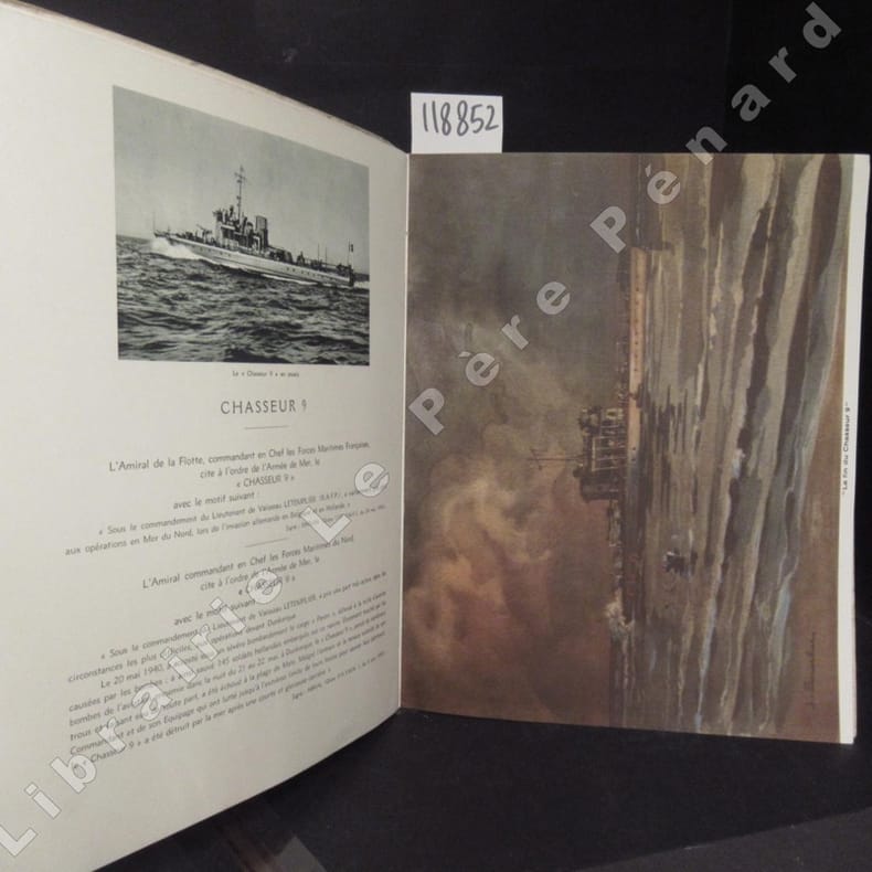
118852sd Sans mention d'édition / Héliogravure Maurice Lescuyer, 16 Rue des Remparts-d'Ainay, Lyon / Visa N° 69. Section des Informations Maritimes. Secrétariat d'Etat à la Marine - Sans date (Approx. 1950) - Grand in-4, broché avec décor sur la première de couverture - 50 pages - Illustrations et reproductions photographiques en N&B in et hors texte (2 grandes illustrations de Jacques Touchet en couleurs hors texte) - Exemplaire numéroté N° 400 / 500
DADAX4431544747Springer 2014-03-27. 2014. hardcover. New. 6.14x0.88x9.21. Buy with confidence. Excellent Customer Service & Return policy. Springer hardcover
98245Paris, Editions du Galion d’Or 1927, 235x185mm, frontispice, 162pages, broché. Petits accrocs entre le haut du dos et la couverture supérieure et ocouverture inféireure presque détachée, autrement bel exemplaire, intérieur propre. Edition originale sur papier vergé d’Auvergne à la forme, numérotée n.° 213 / 500.
50035Paris Imprimerie Nationale 1977 in 4 (30,5 x 21,5) 2 volumes reliures toilées bleues ornée de l'éditeur, etui toilé assorti, dos et plats supérieurs titrés et otnés sur les plats supérieurs d'une vignette en couleurs contrecollée, 516 pages [1], et 579 pages [1], avec de nombreuses illustrations en noir et blanc et en couleurs, et 3 cartes dépliantes volantes insérées dans un soufflet sur le plat intérieur du tome 2. Collection ''Voyages et Découvertes''. Journaux de navigation établis et documentés par Etienne Taillemite. Bel exemplaire ( Photographies sur demande / We can send pictures of this book on simple request ) Poids du colis: 6 kgs
280 pages. Index. Bibliography. Archival black and white photos abound, plus several in colour. Includes maps, timetables and scale drawings. "This is the dramatic story of the CPR's British Columbia sternwheelers and steam tugs through the races, boiling rapids, moonlit cruises, and gold rushes to their passing." - from dust jacket. Light wear to clean and unmarked book. Average wear and closed tears to back panel of dust jacket which is now preserved in glossy new archival-grade Brodart cover. Sound copy of this wonderful piece of B.C. history. Book
192759226Washington D.C.: Government Printing Office Hydrographic Office U.S. Navy 1927-1928. Two vols. 8vo. 8 viii 424; 6 v 1 446 pp. With 4 large folding colour maps 1 double-sided elevation maps showing harbor entrances numerous photo plates. Beige publisher’s cloth black lettering front cover & spine darkening to spine fore-edges minor shelfwear dustsoiling still VG set. Third & Seventh editions revised & updated of these coast pilot guides to Central America and Mexico in the 1920’s. Prior to modern GPS systems and satellite navigation these regularly updated and revised navigation handbooks provided key sailing instructions often drawing not only from Mexican and West Indies sources but also governmental publications in the Panama Canal sailing reports from U.S. Navy vessels and those from merchant ships. The first large map delineates not only the requisite coast pilots for sailing in American waters but also the charts to be ordered from the Hydrographic Office. Government Printing Office, Hydrographic Office, U.S. Navy, hardcover
18880009730New York 1888. First edition. Map. Fine. 15 x 11 inches / 36 x 26 cm 3 folds matted glazed and framed. Very Scarcce <br/><br/>This map was removed from an Annual Report. The black-and-white map shows the boundaries of Illinois in outline presenting the Illinois River improved passage from Chicago to Grafton where it pours into the Mississippi River. It also shows the Rock River traversing to the Quad Cities. Toward the east is the Illinois & Michigan Canal the DesPlaines River the Little Calumet River and the Little Kankakee River and Calumet Harbor. The map is attributed to Thomas H. Handburg. The University of Illinois-Urbana has a photocopy of it from the photocopy in the National Archives. I have not identified to which Annual Report this belonged Nor can I find another map attribued to Thomas H. Handburg. unknown
Very Good Turkish, Ottoman (1500-1928) Original color map. Elephant folio. (59x75 cm). In Ottoman script. [OTTOMAN MILITARY MAP of PATAGONIA and FALKLAND ISLANDS: ROUTE of DRESDEN] Alman kruvazörü Dresden'in takîbi ve tahrîbi. SMS Dresden cruiser's routes between 1913-1915 (World War 1) on the Patagonian shelf; western shores of South America, Patagonia and Falkland Islands. Dresden spent much of her career overseas. After commissioning, she visited the United States in 1909 during the Hudson-Fulton Celebration, before returning to Germany to serve in the reconnaissance force of the High Seas Fleet for three years. In 1913, she was assigned to the Mediterranean Division. She was then sent to the Caribbean to protect German nationals during the Mexican Revolution. In mid-1914, she carried the former dictator Victoriano Huerta to Jamaica, where the British had granted him asylum. She was due to return to Germany in July 1914, but was prevented by the outbreak of World War I from doing so. At the onset of hostilities, Dresden operated as a commerce raider in South American waters in the Atlantic, then moved to the Pacific Ocean in September and joined Maximilian von Spee's East Asia Squadron. Dresden saw action in the Battle of Coronel in November, where she engaged the British cruiser HMS Glasgow, and at the Battle of the Falkland Islands in December, where she was the only German warship to escape destruction. She eluded her British pursuers for several more months, until she put into Robinson Crusoe Island in March 1915. Her engines were worn out and she had almost no coal left for her boilers, so the ship's captain contacted the local Chilean authorities to have Dresden interned. She was trapped by British cruisers, including her old opponent Glasgow. The British violated Chilean neutrality and opened fire on the ship in the Battle of Más a Tierra. The Germans scuttled Dresden and the majority of the crew escaped to be interned in Chile for the duration of the war. The wreck remains in the harbor; several artifacts, including her bell and compass, have been returned to Germany.
180755849Philadelphia: Published by B.B. Hopkins and Co. and sold by W.P. Farrand No. 170 Printed by T. & G. Palmer 1807. 8vo. xxiii 1 270; 271-275 1 40 16 15-16 17-220 4 pp. including binders instructions and publisher’s advertisement. With 7 copper-engraved plates & maps 6 engraved by Benjamin Tanner. Contemporary polished brown calf red & gilt morocco spine label chipping to head of spine minor edgewear occasional interior foxing & toning still a VG- copy from the library of John L. Gow 1797-1866 noted Pennsylvania attorney w/ ownership label and markings on front pastedown. First American edition of this classic navigation handbook which was first published in 1804 and here contained substantial corrections to the tables of the latitudes and longitudes of places on the American coast and in the West Indies as well as an improved system of finding the longitude by P. Delamar of Philadelphia. Mackay 1760-1809 was noted Scottish mathematician and astronomer taught navigation and instructed in methods of how to find longitude. Shoemaker 12965. Published by B.B. Hopkins and Co., and sold by W.P. Farrand, No. 170, Printed by T. & G. Palmer, unknown
194539135Chatham: Shepherd Printing n. d. ca 1945. 1945. CANADA. 18" x 24" sheet one side opens to a half-sheet color map and numerous advertisements for lodging including the Joe Gawa Hotel one of Ontario's newest and finest hotels. The other side has 12 panels of promotional text regarding the various cruise packages of the beautiful Muskoka Lakes time tables and schedules and views of the inland waterways steamships R. M. S. Sagamo and the R. M. S. Cherokee. Some minor to light wear to the folds else a very good copy. Shepherd Printing, n. d. (ca 1945). unknown
195540503City Not Stated: Peninsular & Oriental Steam Navigation Company P & O 1955. Each card: Folded small octavo 14 x 21 cm very good condition colour drawing front cover corner tips some cards little scuffed card 1 is slightly shorter at the top presumed as issued no text missing minor edgewear. Each card: 4 pp. A set of 11 of 12 in set menu cards designed by the artist Strom Gould. Card No. 1 Red-Crowned Pigeon & Purple-Crowned Pigeon. Card No 2 Fairy Wrens. Card No. 3 Gouldian Finch. Card No. 4 Pink Cockatoo. Card No. 5 Count Raggi's Bird Of Paradise. Card No. 6 Rainbow Bird. Card No. 7 Regent Bower-Bird. Card No. 8 Scarlet Honey-Eater. Card No. 9 Red-Capped Robin. Card No. 10 Laughing Kookaburra. Card No. 11 Rainbow Lorikeet Red-Winged Parrakeet & Green Leek Parrakeet. MISSING: Card No. 12 Kingfisher. The artist also known as Charles Sidebotham Gould was born in Letchworth England on 2/8/1910 and came to Australia in 1937. He was employed as the Sydney Morning Herald's first art director and he also drew its first comic strip in 1944. He died in 1992. No date but about 1955. Peninsular & Oriental Steam Navigation Company (P & O) unknown
Very Good English Original bdg. HC. 4to. (30 x 22 cm). In English. 2 volumes set: (1338, 975 p.; 1339 -2650 pp., 976-1901 pp.), many plans, reports. Guide to port entry. 1997 / 98 Edition. 2 volumes set. Vol. 1: Albania to Kuwait. Vol. 2: Latvia to Zaire. A very heavy and oversize set.
20182-4431567801Springer 2018. Paperback. New. reprint edition. 260 pages. 9.25x6.10x0.59 inches. Springer paperback
187355613Washington Government Printing Office 1873. Royal8vo. Orig. full calf. Gilt boders and gilt lettering on covers. Gilt spine. Lithographed frontispiece in colour. XVI107203268 pp. 3 lithographed colourplates one large folded. unknown
187355613Washington, Government Printing Office, 1873. Royal8vo. Orig. full calf. Gilt boders and gilt lettering on covers. Gilt spine. Lithographed frontispiece in colour. XVI,107,203,26,8 pp., 3 lithographed colourplates (one large folded).
197250749Grenoble Editions des Quatre 1972 Grand in-4, veau bleu nuit, encadrement de filets froid sur les plats, dos sans nerfs orn petits fers dors; doublures et gardes de tabis vert, tranches dores (reliure de l'diteur).Belle dition reproduisant en fac-simil (au format) l'dition originale de ce trait publie par Moutard en 1781 et illustre d'un grand en-tte et de 9 planches hors texte. Tirage limit 570 exemplaires numrots. Un des 50 premiers exemplaires, seuls tre prsents dans une reliure de l'diteur. Etat neuf.
181828428Tours NANTES 1818 une page, format : 20,5 x 16,2 cm, sur papier vergé crème ligné à en-tête et texte pré-imprimé en noir et manuscrit à l'encre brune, signature manuscrite :BRICAULD, MAIRIE DE TOURS : DEMANDE D'AUTORISATION DE DÉCHARGER AU PORT DE : LA FOIRE LE ROI PAR LE SIEUR VANDANGEAU SUR BATEAU "ACCÉLÉRÉ" DE NANTES, SAVOIR - 1 SAC DE SUCRE, 1 CAISSE IDEM, 2 SACS IDEM, 2 BARILS IDEM, 1 SAC DE RIZ, 1 BALLOT D'ÉPICERIES, 4 BALLES DE PAPIER, 1 PANIER DE PLUMES, FAIT A TOURS, LE 19 JUIN 1818,
194814441Le Havre Marcel Etaix 1948 Quatre volumes in-8 demi veau raciné, dos lisse, titre et tomaison dorés, 137, 315, 210 et 310 pages. Bel ensemble.
1829vj784Dezauche, géographe Broché 1829 In-8 (13.5x21.5 cm), broché, couverture papier artisanale, fenêtre de titre au dos, 222 pages, 7 feuillets non paginés de tables (3 tables e, 7 feuillets), suivi de 32 pages de 'Notes supplémentaires au manuel de gréement' (1837) et une planche dépliante de tableau, 2e édition corrigée et augmentée ; déchirures aux coiffes, mors fendus sur les trois quarts de la longueur, coins pliés, état correct. Livraison a domicile (La Poste) ou en Mondial Relay sur simple demande.
1930822DGca. 1930. Farbiges Aquarell. 18 x 10 cm. + Wichtig: Für unsere Kunden in der EU erfolgt der Versand alle 14 Tage verzollt ab Deutschland / Postbank-Konto in Deutschland vorhanden +, A
1852NATW3326Berlin, Nicolai 1836 / 1852. 528; 316 S., Ppbde. d. Zeit, Kanten u. Rücken berieben, Exlibris auf Spiegel d. 2. Bandes. Enthält u.a "Von einigen Thatsachen, die sich auf Christoph Columbus und Amerigo Vespucci beziehen", weiters ein umfangreiches Namen- und Sachverzeichnis.