6 260 résultats
1982RO80124264HACHETTE - GUIDES BLEUS. 1982. In-12. Broché. Bon état, Couv. convenable, Dos satisfaisant, Intérieur frais. 190 pages. Nombreuses photos et quelques cartes, en noir et blanc, dans le texte.. . . . Classification Dewey : 996-Autres régions du pacifique
199462187Woodland WA: Irish Press 38606 NW Goose Hill Rd. 1994. 4to. v 1 368 pp. With photos illustrated plates maps. Green publisher’s buckram gilt lettering on spine signed & numbered by the author on limitation page from the library of Tom Koenninger 1932-2010 former editor managing editor journalist for The Columbian newspaper and board member on the Vancouver National Historic Trust. First edition signed No. 60 of 65 copies printed of this work compiled from the original ship’s logs logbooks manuscripts letters memoirs and accounts books of Captain Robert Gray’s ship Columbia; Hudson’s Bay Co. records and other documents recording the explorations of Captain Benjamin Bonneville 1832-1835; notes on Pacific Northwest Native American Indigenous Peoples including descriptions of native plants medicine food & housing; Fort Vancouver Cowlitz Farm Hudson’s Bay Company values Whitman murders Native American treaties with Stevens and much more. Irish Press, 38606 NW Goose Hill Rd., hardcover
"The GTP ran from Winnipeg via Edmonton and the Yellowhead Pass to Prince Rupert and was built to challenge the primacy of the Canadian Pacific Railway. The 1,500-km British Columbia line, built at great cost over some of the country's most rugged terrain, was completed in 1914, but traffic fell far short of company expectations and this contributed to the collapse of the GTP in 1919. This failure is examined here, with focus on the problems of the BC line. Leonard argues that 'a thousand blunders' by company managers were primarily responsible for one of the greatest failures in Canadian entrepreneurial history. Richly detailed and thoroughly documented, this study makes an important contribution to the fields of railway and business history, as well as to the study of the history of northern British Columbia." - half-title. Book clean, bright and unmarked with negligible wear. Very light wear to dust jacket which is sunned at backstrip and now preserved in glossy new archival-grade Brodart. pp. x, 344. Extensive footnotes, bibliography and index. Numerous maps, tables and black and white illustraitons. A high quality copy. Book
0331939053.Ghardcover. Good. Access codes and supplements are not guaranteed with used items. May be an ex-library book. hardcover
39650Np. Le Pacifique Canadien. Canadian Pacific Railway. 1921. Soft cover. sm4to. 24.5cm c.66 pages with 18 colour plates mainly by C.W. Simpson John Johnstone. printed on a fine grain art paper printed wraps very good to fine rare. n12 Eight of the colour plates are from painting by C.W. Simpson. Np. Le Pacifique Canadien. (Canadian Pacific Railway). 1921 unknown
1997100144180Peeters Publishers 1997 99 pages 16 002x1 27x23 876cm. 1997. Broché. 99 pages.
1527940357.Gpaperback. Good. Access codes and supplements are not guaranteed with used items. May be an ex-library book. paperback
Back hinge started. Spine a bit slanted. Gilt lettering and gilt spine lettering a bit faded ; Ex-Lib; 8vo; 309 pages
Light wear to spine ends. Gilt spine lettering a bit faded. Bookplate; B&W Photographs; 8vo; 309 pages
The second book of the adventuresome author's exploits covers his journeys to the South Pacific and his outspoken reminiscences thereof. ; Ex-Library; B&W Photographs; 8vo; 328 pages
1331825989.Gpaperback. Good. Access codes and supplements are not guaranteed with used items. May be an ex-library book. paperback
1528376277.Ghardcover. Good. Access codes and supplements are not guaranteed with used items. May be an ex-library book. hardcover
xiii, 64 p. illus., ports., two foldout charts, plan. 25 cm. Hardcover Very good condition, owners name on endpaper fair
4to [30.5 x 23.5 cm]; xxix, [ii, errata, directions leaf], 360, 47 pp, 22 plates and maps including 6 folding maps and charts, tables, with the half title page (often lacking). contemporary leather backed marbled boards, gilt spine title lettering, joints rubbed, corners worn round, some light staining to about 5 plates at rear, mostly marginal, generally clean and unmarked, very good, a tall copy with wide margins. A picture of Two ships, the King George commanded by Portlock and the Queen Charlotte, commanded by George Dixon, visited the Falkland Islands, made a long stay at Hawaii, then proceeded to survey the American coast, to more accurately map the coast and to establish a British presence in the region's fur trade. National Maritime Museum 140: 'Dixon discovered Queen Charlotte Island, named after his ship'. Buck 35. Sabin 20364. Howes D365. Wickershaam 6574. Lada-Mocarski 43. Hill 352: 'This expedition set out to establish a trade in furs in North America. Dixon visited Hawaii three times in the course of the voyage. . .discovered Queen Charlotte Islands, Port Mulgrave, Norfolk Bay, Dixon Entrance and Archipelago while continuing down the coast and trading with the Indians.. . . Dixon's contribution to the work also includes the valuable maps. The accounts of this expedition relate to the geography, ethnology, and natural history of the American coast from Nootka Sound northward'. The fine plates including many views, birds, portrait, etc. One of the detailed appendices is on the natural history encountered. Dixon had earlier sailed with Cook on the Resolution
4to [29 x 24.5 cm]; [ii], xxiii, [i, errata], 388, 13, [i, directions] pp, engraved frontis portrait, plus 32 engraved plates, maps and charts including 20 folding. orig full tree calf, rebacked with orig gilt decorated spine, gilt title lettering on orig red spine leather label, wear at corners & spine ends, armorial bookplate of Robert Austen, marbled endpapers, interior clean, crisp & fine with only slight foxing. Taylor 401. Cox i, 301. Hill p. 108: 'Forrest sailed from Balembangan, in the 'Tartar', a native prahu of about ten tons burden, with two English officers and eighteen Malays, towards the Moluccas. He pushed further east than any of his company predecessors, eventually reaching Geelvink Bay in New Guinea. The voyage was one of examination and enquiry . . . the tact with which he conducted his intercourse with the natives, and the amount of work done in a small boat, deservedly won him credit as a navigator'. They explored the Gilolo Passage between New Guinea and the Moluccas, then sailed to Mindanao, examining the Sulu Archipelago, Mandiolo, Batchian and Waygiou, and reaching the Malay peninsula A vocabulary of the Magindano tongue is added at the end of the book. There is much on the native people, their customs, manners, activities. The book is famous for its fine engraved plates and maps.
8vo [21 x 14.5 cm]; xxxi, [i], 212 pp, frontis, 2 double-page plates, double page map, 2 facsimiles of title pages from original edition, table. original cloth, rubbed at edges, signature on endpaper, very good. A picture of this book is available upon request by email. Hill p 38; Sabin 9108, Borba de Moreaes p 133. The Voyage describes the loss of the Wager, a transport in Anson's squadron which was wrecked in the Golfo de Penas on the Chilean coast. Following the wreck, a mutinous split occurred, resulting in this voyage of one of the factions to Rio de Janeiro in the long boat. An account of the sufferings of the officers left behind was later published by John Byron. There were later editions published in 1752 and 1757. The introduction by Arthur D. Howden Smith provides an historical perspective. The first edition was 1743 with several printings in the eighteenth century. This is the third edition, and not reprinted since 1757.
367p., illus. Hardcover Very good condition tattered d.j. fair
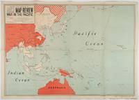
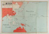
1944222858Cairo.: Printing and Stationery Services M.E.F. Late1944. Colour map of the Pacific theatre. 66 x 93.5cm folding into eight panels. Occasional foxing though principally within the margins image itself largely unaffected. A curiously scarce map of the Pacific showing the furthest advance of Japanese forces and Allied progress in reclaiming lost territories. Although particular care has been devoted to marking out naval bases a few creative liberties have been taken in the way of the true extent of the Japanese advance across the Pacific particularly in the Aleutians. . Printing and Stationery Services, M.E.F. unknown
1944222584Cairo.: Printing and Stationery Services M.E.F. Late1944. Colour map of the Pacific theatre. 66 x 93.5cm folding into eight panels. Some light foxing to the margins a few repairs at folding points a few light creases but a bright and very good copy. A curiously scarce map of the Pacific showing the furthest advance of Japanese forces and Allied progress in reclaiming lost territories. Although particular care has been devoted to marking out naval bases a few creative liberties have been taken in the way of the true extent of the Japanese advance across the Pacific particularly in the Aleutians. . Printing and Stationery Services, M.E.F. unknown
(Codice VI/0221) In 8º (27 cm) 80 pp. Auction catalogue, 217 items, many colour illustrations. Original softcover, fine. ~~~ SPEDIZIONE IN ITALIA SEMPRE TRACCIATA
(Codice VI/0222) In 8º (27 cm) 316 pp. Auction catalogue, 595 items, many colour illustrations, 1 folding plate. Original softcover, fine. ~~~ SPEDIZIONE IN ITALIA SEMPRE TRACCIATA
240 pages. Features: The Energy of Bobby Kennedy, Jr.; Stella McCartney on Design & Ethics; Roberto Saviano on Life After Gomorrah; David de Rothschild's Anti-Plastic Pacific Adventure; Jacques Cousteau's Underwater House; Deep Ecology; Philippe Parreno's Post-Apocalypse; Sustainable Sushi; The Missing Link Between Fashion & Fish. Unmarked with above-average but not excessive wear. A worthy reading copy. Book
1331916429.Gpaperback. Good. Access codes and supplements are not guaranteed with used items. May be an ex-library book. paperback
0666229503.Ghardcover. Good. Access codes and supplements are not guaranteed with used items. May be an ex-library book. hardcover